Texas Spring-2015
Moderator: S2k Moderators
Forum rules

The posts in this forum are NOT official forecast and should not be used as such. They are just the opinion of the poster and may or may not be backed by sound meteorological data. They are NOT endorsed by any professional institution or STORM2K.

-
weatherdude1108
- Category 5

- Posts: 4228
- Joined: Tue Dec 13, 2011 1:04 pm
- Location: Northwest Austin/Cedar Park, TX

-
Nikki

- S2K Supporter

- Posts: 291
- Joined: Mon Jun 21, 2010 3:38 pm
- Location: Santa Fe, TX (yes I typed that right TEXAS not New Mexico, I am about 20 miles from Galveston, TX)
Re:
Tireman4 wrote:Just wait until next week...Tee Hee
Why?
0 likes
My name is Nicole and this is what I go by in Storm2k chat! Come chat with us! We have fun in there too!!
A teacher's purpose is not to create students in her own image, but to develop students who can create their own image. ~Author Unknown
Alicia, Allison, Rita, Ike
A teacher's purpose is not to create students in her own image, but to develop students who can create their own image. ~Author Unknown
Alicia, Allison, Rita, Ike
-
BrokenGlassRepublicn
- Category 1

- Posts: 483
- Joined: Sun Nov 20, 2011 8:07 pm
- Location: Richardson, Texas
-
Ralph's Weather
- S2K Supporter
- Posts: 3371
- Age: 38
- Joined: Fri Dec 13, 2013 11:55 am
- Location: Lindale, TX
- Contact:
Storms also along I-20 and just south of I -20 in East Texas.
0 likes
Follow on Facebook at Ralph's Weather.
Re: Texas Spring-2015
Nearly all guidance is still showing 2+ inch PW values coming from the Caribbean thru the Gulf of Mexico and into SE TX Friday night-Sunday afternoon. Global models mostly keep the heavy rain along the immediate coastal area (2-4+ inches) and less coverage further inland (1/2-1 inch).
Now that we are less than 72 hours out we can start seeing what signals the short term mesoscale models are indicating. For example, we are now in range of the NAM-12km and it is painting a wet picture for SE TX this weekend with nearly all of the area recieving between 1 and 2 inches with isolated totals of 4+ inches where training cells setup. Of course we won't know where this heaviest rain falls until the event begins to unfold, but is appearing more likely somewhere along the upper texas coast could see a heavy rain event this weekend.
Below is accumulated precipitation thru 7PM CST Saturday (which is likely only halfway thru the rain event).
0 likes
-
weatherdude1108
- Category 5
- Posts: 4228
- Joined: Tue Dec 13, 2011 1:04 pm
- Location: Northwest Austin/Cedar Park, TX
Re: Texas Spring-2015
fendie wrote:Nearly all guidance is still showing 2+ inch PW values coming from the Caribbean thru the Gulf of Mexico and into SE TX Friday night-Sunday afternoon. Global models mostly keep the heavy rain along the immediate coastal area (2-4+ inches) and less coverage further inland (1/2-1 inch).
Now that we are less than 72 hours out we can start seeing what signals the short term mesoscale models are indicating. For example, we are now in range of the NAM-12km and it is painting a wet picture for SE TX this weekend with nearly all of the area recieving between 1 and 2 inches with isolated totals of 4+ inches where training cells setup. Of course we won't know where this heaviest rain falls until the event begins to unfold, but is appearing more likely somewhere along the upper texas coast could see a heavy rain event this weekend.
Below is accumulated precipitation thru 7PM CST Saturday (which is likely only halfway thru the rain event).
If you can edge that a tad further west into central Texas, I would greatly appreciate it.
0 likes
-
TeamPlayersBlue

- Category 5
- Posts: 3531
- Joined: Tue Feb 02, 2010 1:44 am
- Location: Denver/Applewood, CO
Ive seen things like this turn into a system, we should keep our eyes peeled. Any idea what the upper level winds look like? Favorable or not?
0 likes
Personal Forecast Disclaimer:
The posts in this forum are NOT official forecast and should not be used as such. They are just the opinion of the poster and may or may not be backed by sound meteorological data. They are NOT endorsed by any professional institution or storm2k.org. For official information, please refer to the NHC and NWS products.
The posts in this forum are NOT official forecast and should not be used as such. They are just the opinion of the poster and may or may not be backed by sound meteorological data. They are NOT endorsed by any professional institution or storm2k.org. For official information, please refer to the NHC and NWS products.

Re: Texas Spring-2015
It will be interesting to see how this all plays out. The models are split with regards to next week. Would like to see the rain last longer. The top soil layer has become dry around here, although dig down a little and you will find its still relatively moist, it's time to maintain that with more rain.
These past 11 days were needed to decrease the flood threat and the good thing is temps have been nice for this time of year.
These past 11 days were needed to decrease the flood threat and the good thing is temps have been nice for this time of year.
0 likes
Resident Rain Miser
I am a weather hobbyist living 3.5 miles south of Downtown Austin and in no way or fashion should anything I say concerning forecasts be taken seriously. Please check your local NWS for accurate weather forecasting and conditions.
I am a weather hobbyist living 3.5 miles south of Downtown Austin and in no way or fashion should anything I say concerning forecasts be taken seriously. Please check your local NWS for accurate weather forecasting and conditions.
-
weatherdude1108
- Category 5
- Posts: 4228
- Joined: Tue Dec 13, 2011 1:04 pm
- Location: Northwest Austin/Cedar Park, TX
Re: Texas Spring-2015
JDawg512 wrote:It will be interesting to see how this all plays out. The models are split with regards to next week. Would like to see the rain last longer. The top soil layer has become dry around here, although dig down a little and you will find its still relatively moist, it's time to maintain that with more rain.
These past 11 days were needed to decrease the flood threat and the good thing is temps have been nice for this time of year.
Ditto that.
0 likes
-
weatherdude1108
- Category 5
- Posts: 4228
- Joined: Tue Dec 13, 2011 1:04 pm
- Location: Northwest Austin/Cedar Park, TX
This is encouraging.


0 likes
The preceding post is NOT an official forecast, and should not be used as such. It is only the opinion of the poster and may or may not be backed by sound meteorological data. It is NOT endorsed by any professional institution including storm2k.org. For Official Information please refer to the NHC and NWS products.

-SOI burst coming, southeast ridge and Carlos has formed south of Mexico. All good signs of rain coming. Nothing like April and May as the seasons have change and summer is a climo dry period but any rain is important in keeping the feedback away from heat. Heat ridges have not been able to form across the central conus thus far.
0 likes
The above post and any post by Ntxw is NOT an official forecast and should not be used as such. It is just the opinion of the poster and may or may not be backed by sound meteorological data. It is NOT endorsed by any professional institution including Storm2k. For official information, please refer to NWS products.
Help support Storm2K!
-
aggiecutter
- Category 5
- Posts: 1755
- Joined: Thu Oct 14, 2004 9:22 pm
- Location: Texarkana
Re: Texas Spring-2015
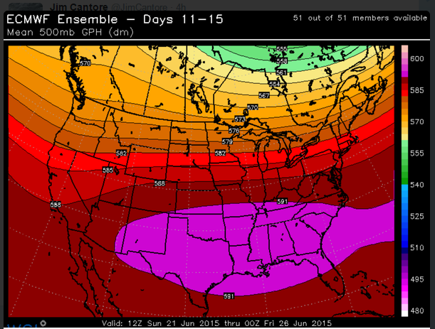
At the end of the month, the heat will be on:
And some El-Nino information:
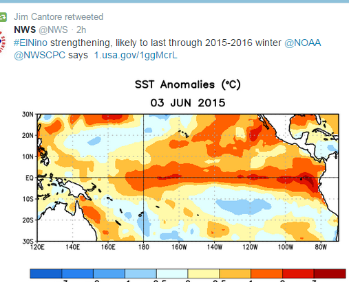

And some El-Nino information:

0 likes
-
high_lander
- Tropical Low

- Posts: 34
- Joined: Tue Jan 01, 2013 7:02 pm
- Location: Little Elm, TX
Re: Texas Spring-2015
Does that mean the snowy fun we had this last Winter will continue this Winter?
0 likes
-
Texas Snowman

- Storm2k Moderator

- Posts: 6197
- Joined: Fri Jan 25, 2008 11:29 am
- Location: Denison, Texas
Re: Texas Spring-2015
Another brilliant Fort Worth NWS forecast discussion from Mr. Cavanaugh this morning.
The snippet I focused on is the portion discussing rain - potentially, flooding rains - next week:
"SATURDAY...DEEP SOUTHERLY FLOW IS EXPECTED OVER THE REGION...WHICH
SHOULD ALLOW PRECIPITABLE WATER (PWAT) VALUES TO CLIMB THROUGHOUT
THE WEEKEND. ON SATURDAY...EVEN THOUGH MOISTURE IS EXPECTED TO
DEEPEN...WITH THE SOUTHERN CALIFORNIA SHORTWAVE TROUGH MOVING OFF
TO THE NORTHEAST...AND UPPER LEVEL RIDGING TO THE EAST AND
SOUTHWEST...THERE IS NO OBVIOUS LARGE SCALE LIFT OR SUBSIDENCE IN
PLACE OVER THE CWA ON SATURDAY. AS A RESULT...IT IS CERTAINLY
POSSIBLE THAT SATURDAY JUST REMAINS DRY FOR MUCH OF NORTH AND
CENTRAL TEXAS. MAINTAINED A 20 TO 30 POP ACROSS THE AREA BECAUSE
ALMOST ALL MODEL GUIDANCE ADVERTISES SPURIOUS QPF RANDOMLY OVER
THE AREA ON SATURDAY. IT IS CERTAINLY POSSIBLE THAT SOME DYNAMIC
REMNANTS FROM FRIDAY NIGHTS CONVECTION WILL BE IN PLACE AND
LOCALLY ENHANCE THUNDERSTORM CHANCES...HOWEVER WE WILL NOT KNOW
THAT UNTIL SATURDAY MORNING. AIR MASS THUNDERSTORMS MAY SIMPLY
DEVELOP RANDOMLY ACROSS THE CWA SATURDAY WITH NO STRONG CAP OR
SUBSIDENCE SUPPRESSING CONVECTION. THE COVERAGE WOULD PROBABLY
REMAIN ISOLATED TO SCATTERED IN NATURE THOUGH WITHOUT ANY OBVIOUS
FOCUS.
SUNDAY...A SECOND SHORTWAVE TROUGH IS EXPECTED TO FILL IN BEHIND
THE SOUTHERN CALIFORNIA SHORTWAVE TROUGH AND SPREAD SOME LARGE
SCALE LIFT OVER THE REGION SUNDAY AFTERNOON. THIS LIFT IS NOT
EXPECTED TO BE OVERLY STRONG...HOWEVER THERE IS AT LEAST SOME
ORGANIZED LIFT THAT MODELS PLACE OVER THE AREA...SO THINK THAT THE
COVERAGE OF STORMS WILL BE GREATER SUNDAY AFTERNOON VERSUS
SATURDAY AFTERNOON AS A RESULT. DO NOT EXPECT ANY ORGANIZED SEVERE
STORMS THIS WEEKEND...HOWEVER IT`S DIFFICULT TO EVER RULE OUT A
DAMAGING MICROBURST AS THUNDERSTORMS GROW QUICKLY AND COLLAPSE.
THE OTHER THING TO WATCH FOR ON SUNDAY IS THE REMNANTS OF THE
BROAD UPPER TROUGH THAT IS CURRENTLY CENTERED NEAR NEW ORLEANS.
THE GFS AND CANADIAN INDICATE THAT THIS FEATURE MAY MOVE NORTH
OVER FAR SOUTH TEXAS AND ENHANCE THE TRANSPORT OF TROPICAL
MOISTURE NORTHWARD OVER THE EASTERN HALF OF NORTH TEXAS SUNDAY
AFTERNOON. THE CANADIAN GOES A STEP FURTHER AND ACTUALLY ALLOWS
THIS REMNANT CIRCULATION TO STEER A VERY WEAK TROPICAL DISTURBANCE
NORTH UP THE I-35 CORRIDOR SUNDAY AFTERNOON. THIS LOOKS A BIT TOO
AMBITIOUS...HOWEVER THE GENERAL PATTERN WARRANTS WATCHING THIS
WEEKEND. IF THE REMNANTS OF THE NEW ORLEANS UPPER TROUGH REMAIN
COHERENT AND LIFT NORTH ON SUNDAY...AN ADDITIONAL SLUG OF TROPICAL
MOISTURE MAY RESULT IN A SHORT TERM FLASH FLOOD THREAT SUNDAY
AFTERNOON AND EVENING. DO NOT HAVE THIS IN THE GRIDS AT THIS TIME
AS THE GFS/CANADIAN/ECMWF TECHNICALLY ALL TREAT THE EVOLUTION OF
THESE REMNANTS DIFFERENTLY. WILL WATCH THIS SITUATION CLOSELY AS
WE MOVE INTO THE WEEKEND THOUGH...AND MAY HAVE TO PREPARE FOR A
LOCALIZED FLASH FLOOD THREAT SUNDAY AFTERNOON/EVENING IF SOME
SOLUTION SIMILAR TO THE GFS OR CANADIAN VERIFIES.
NEXT WEEK...THERE ARE REALLY TWO COMPETING LARGE SCALE MODEL
SOLUTIONS FOR NEXT WEEK...ONE OF WHICH IS MORE OR LESS DRY FOR
THE CWA...AND THE OTHER WHICH MAY SUPPORT A COUPLE OF DAYS OF
WIDESPREAD HEAVY RAINFALL AND POSSIBLE FLOODING.
THE DRY SOLUTION...THE ECMWF MORE OR LESS BACKS THIS SOLUTION. THE
10/12Z RUN WAS DRIER THAN THE 11/00Z RUN...BUT THE GENERAL PATTERN
IS DRIER THAN THE GFS. THIS SOLUTION INDICATES THAT THE
SOUTHEASTERN CONUS UPPER RIDGE STRENGTHENS THROUGHOUT THE WEEK
WHILE EXPANDING WESTWARD. BY WEDNESDAY THE ECMWF HAS THE LARGE
CENTER OF THIS RIDGE PUSHING AS FAR WEST AS THE TX/LA BORDER. THIS
ESSENTIALLY PLACES THE CWA UNDER SUBSIDENCE AND SENDS DEEP
TROPICAL MOISTURE TO THE WEST AND NORTH OF THE CWA.
THE WET SOLUTION...THE 11/00Z GFS BACKS THIS SOLUTION. THE GFS HAS
A RIDGE IN ESSENTIALLY THE SAME PLACE AS THE ECMWF...BUT THE GFS
IS A BIT WEAKER WITH THE UPPER RIDGE AND MORE IMPORTANTLY...DOES
NOT PUSH THE CENTER OF THE RIDGE AXIS AS FAR WEST AS THE ECMWF.
THE GFS KEEPS THIS WESTERN EDGE OVER MISSISSIPPI. IF THIS SOLUTION
VERIFIES...IT ACTUALLY SENDS A STREAM OF DEEP TROPICAL MOISTURE UP
FROM THE GULF OF MEXICO NORTH OVER THE CWA FOR TUESDAY THROUGH
THURSDAY. THIS COUPLED WITH A PERSISTENT SHEARED OUT TROUGH AXIS
HANGING IN PLACE OVER THE TEXAS PANHANDLE RESULTS IN LARGE SCALE
CONVERGENCE AND WEAK BUT PERSISTENT LIFT OVER THE CWA. IF THIS
VERIFIES...IT APPEARS TO BE A LARGE SCALE PATTERN THAT IS
FAVORABLE FOR WIDESPREAD HEAVY RAINFALL AND FLOODING. THE GFS
ADVERTISES PWATS OF 2.25 TO 2.5 INCHES OVER THE CWA IN THIS
REGIME...WHICH IS OVER 2 STANDARD DEVIATIONS ABOVE NORMAL.
AT THIS TIME...IT IS SIMPLY TOO HARD TO SAY WHICH SOLUTION WILL
VERIFY. THERE IS NO OBSERVATIONAL EVIDENCE THAT CURRENTLY SUGGESTS
ONE MODEL IS MORE LIKELY TO VERIFY THAN THE OTHER...SO JUST
BLANKETED CHANCE POPS OVER THE REGION FOR TUESDAY INTO WEDNESDAY
IN THE EXTENDED FORECAST. THIS IS OBVIOUSLY A PATTERN TO KEEP A
CLOSE EYE ON AFTER WE GET THROUGH THIS WEEKEND.
CAVANAUGH"
0 likes
The above post and any post by Texas Snowman is NOT an official forecast and should not be used as such. It is just the opinion of the poster and may or may not be backed by sound meteorological data. It is NOT endorsed by any professional institution including storm2k.org. For official information, please refer to NWS products.
-
Texas Snowman
- Storm2k Moderator
- Posts: 6197
- Joined: Fri Jan 25, 2008 11:29 am
- Location: Denison, Texas
Re: Texas Spring-2015
high_lander wrote:Does that mean the snowy fun we had this last Winter will continue this Winter?
Found a very interesting article out of San Angelo NWS discussing this idea - does El Nino cause snowier winters for North Texas?
At least in the San Angelo and Abilene areas, the answer seems to be yes.
http://www.srh.noaa.gov/images/sjt/hydro/ENSOsnow.pdf
0 likes
The above post and any post by Texas Snowman is NOT an official forecast and should not be used as such. It is just the opinion of the poster and may or may not be backed by sound meteorological data. It is NOT endorsed by any professional institution including storm2k.org. For official information, please refer to NWS products.
-
Lagreeneyes03
- Category 2

- Posts: 610
- Joined: Mon Dec 09, 2013 10:53 am
- Location: Luxurious Lake Grapevine
-
gboudx

- S2K Supporter
- Posts: 4090
- Joined: Thu Sep 04, 2003 1:39 pm
- Location: Rockwall, Tx but from Harvey, La
Re:
Lagreeneyes03 wrote:Did it actually hit 100 in DFW yesterday? According to Accuweather, yesterday's high WAS 100. Loving it!
Maybe that was the Heat Index or some reading west of Ft. Worth. It did not hit 100 at either DFW or Love Field yesterday.
Edit: Ft Worth Meachem Airport reported 100. I don't know why, but that airport always seems to have the hottest readings.
0 likes
Return to “USA & Caribbean Weather”
Who is online
Users browsing this forum: Haddox12, South Texas Storms and 97 guests