Texas Spring-2015
Moderator: S2k Moderators
Forum rules

The posts in this forum are NOT official forecast and should not be used as such. They are just the opinion of the poster and may or may not be backed by sound meteorological data. They are NOT endorsed by any professional institution or STORM2K.
-
WeatherNewbie
- Tropical Storm

- Posts: 235
- Joined: Mon Mar 22, 2010 3:42 pm
- Location: Richardson, Texas
Looks like they just punched through the cap west of Fort Worth.
0 likes
The above post is NOT an official forecast and should not be used as such. It is just the opinion of the poster and may or may not be backed by sound meteorological data. It is NOT endorsed by any professional institution including storm2k.org. For official information, please refer to NWS products.

Cell in NE Parker/NW Tarrant appears to be quickly acquiring supercellular characteristics. From my work at 820 and 35W I can see inflow into the storm and a lowering well off in the distance. I can't tell if it's rotating or not but it's definitely in the right place to be a wall cloud. Warning states tennis ball sized hail. If there is some kind of boundary laying around this could be a nasty storm for the northern burbs.
0 likes
-
TheProfessor

- Professional-Met

- Posts: 3506
- Age: 29
- Joined: Tue Dec 03, 2013 10:56 am
- Location: Wichita, Kansas
-
TheProfessor
- Professional-Met
- Posts: 3506
- Age: 29
- Joined: Tue Dec 03, 2013 10:56 am
- Location: Wichita, Kansas
-
Ralph's Weather
- S2K Supporter

- Posts: 3371
- Age: 38
- Joined: Fri Dec 13, 2013 11:55 am
- Location: Lindale, TX
- Contact:
Just missed a severe storm at my place in Hideaway a bit ago.
0 likes
Follow on Facebook at Ralph's Weather.

Re: Texas Spring-2015
I could see the storms in Canton / Wills Point last night as the sun started going down, 30 miles east of me. Updraft was impressive, just starting to get the infamous anvil shape as I lost daylight and could not see it any more.
0 likes
The above post and any post by dhweather is NOT an official forecast and should not be used as such. It is just the opinion of the poster and may or may not be backed by sound meteorological data. It is NOT endorsed by any professional institution including storm2k.org. For official information, please refer to NWS products.
-
South Texas Storms

- Professional-Met
- Posts: 4259
- Joined: Thu Jun 24, 2010 12:28 am
- Location: Houston, TX
Re: Texas Spring-2015
The long range models have been consistently indicating that a wet weather pattern will arrive for much of the first half of April across Texas (especially the eastern half of the state). April could turn out to be quite a wet month if the models verify. I really hope so!
0 likes
-
Tireman4

- S2K Supporter
- Posts: 5903
- Age: 60
- Joined: Fri Jun 30, 2006 1:08 pm
- Location: Humble, Texas
- Contact:
Re: Texas Spring-2015
South Texas Storms wrote:The long range models have been consistently indicating that a wet weather pattern will arrive for much of the first half of April across Texas (especially the eastern half of the state). April could turn out to be quite a wet month if the models verify. I really hope so!
Cooler Summer..more humid..but cooler...
0 likes
-
weatherdude1108
- Category 5

- Posts: 4228
- Joined: Tue Dec 13, 2011 1:04 pm
- Location: Northwest Austin/Cedar Park, TX
Re: Texas Spring-2015
Tireman4 wrote:South Texas Storms wrote:The long range models have been consistently indicating that a wet weather pattern will arrive for much of the first half of April across Texas (especially the eastern half of the state). April could turn out to be quite a wet month if the models verify. I really hope so!
Cooler Summer..more humid..but cooler...
I am all FOR a wet and cooler April (and Spring for that matter).
It has been miserable here lately with green coating everything from cars to patio furniture, causing itchy eyes, throat, etc. in a lot of people. I am fine so far, but with the constant breeze and lime-green coatings, kind of a drag. Had all that rain in the Winter, then the Oak trees, etc. went crazy with their stuff, as the rain "faucet" has shut off for the last couple weeks.
0 likes
Re: Texas Spring-2015
South Texas Storms wrote:The long range models have been consistently indicating that a wet weather pattern will arrive for much of the first half of April across Texas (especially the eastern half of the state). April could turn out to be quite a wet month if the models verify. I really hope so!
That would be REALLY nice. As noted, washing the pollen out would be super handy right now, I'm dying!!!
0 likes
The above post and any post by dhweather is NOT an official forecast and should not be used as such. It is just the opinion of the poster and may or may not be backed by sound meteorological data. It is NOT endorsed by any professional institution including storm2k.org. For official information, please refer to NWS products.
Re: Texas Spring-2015
From this mornings FWD AFD
AS FOR THE WORK WEEK....AN UPPER LOW CURRENTLY NORTHWEST OF
SEATTLE WILL DIG ALONG THE WEST COAST THROUGH MONDAY...THEN MOVE
EAST ACROSS THE CENTRAL ROCKIES AND FINALLY INTO THE MIDWEST ON
FRIDAY. THIS WILL KEEP NORTH/CENTRAL TEXAS UNDER PERSISTENT
SOUTHWESTERLY FLOW ALOFT AND SOUTHERLY LOW LEVEL FLOW. FORECAST
SOUNDINGS INDICATE THAT WE WILL BECOME AND REMAIN CAPPED FOR MUCH
OF NEXT WEEK...BUT WE COULD HAVE SOME SHOWERS/THUNDERSTORMS IN THE
AFTERNOON/EVENING HOURS WHERE THE CAP IS THE WEAKEST . WEDNESDAY
IS THE ONE DAY THAT THE CAP WEAKENS AS A FEW SMALL UPPER
DISTURBANCES MOVE OVER THE REGION. ANY THUNDERSTORM THAT DEVELOPS
NEXT WEEK WILL BE CAPABLE OF BECOMING STRONG TO SEVERE. LARGE HAIL
WILL THE MAIN THREAT DUE TO VERY HIGH CAPES VALUES.
This is just a broken record.
0 likes
The above post and any post by dhweather is NOT an official forecast and should not be used as such. It is just the opinion of the poster and may or may not be backed by sound meteorological data. It is NOT endorsed by any professional institution including storm2k.org. For official information, please refer to NWS products.

Before we worry about cap and cinh next week enjoy the 0.50 to 1 inch cool rains tomorrow. As for next week things will be very unstable but the cap will be strong. If one of two things happen; either the temperature needs to get really hot or we get sufficient lift. Likely biggest outbreak of the year up to the north from OKC to Nebraska closer to lift.
0 likes
The above post and any post by Ntxw is NOT an official forecast and should not be used as such. It is just the opinion of the poster and may or may not be backed by sound meteorological data. It is NOT endorsed by any professional institution including Storm2k. For official information, please refer to NWS products.
Help support Storm2K!
-
somethingfunny

- ChatStaff

- Posts: 3926
- Age: 37
- Joined: Thu May 31, 2007 10:30 pm
- Location: McKinney, Texas
I got a nice half inch of rain this morning. 
This whole week bears some watching, but Wednesday and particularly Thursday seem the most likely to produce severe storms in Texas.
This whole week bears some watching, but Wednesday and particularly Thursday seem the most likely to produce severe storms in Texas.
0 likes
I am not a meteorologist, and any posts made by me are not official forecasts or to be interpreted as being intelligent. These posts are just my opinions and are probably silly opinions.
-
Ralph's Weather
- S2K Supporter
- Posts: 3371
- Age: 38
- Joined: Fri Dec 13, 2013 11:55 am
- Location: Lindale, TX
- Contact:
Got well over an inch yesterday with temps hovering near 50 all day.
0 likes
Follow on Facebook at Ralph's Weather.
Heads up on the sky this week. We are more capped than folks up north but that just means if any storms breaks the cap will be violent quickly on any given day. Wed night into Thurs is best for widespread thunderstorms. Very wet pattern setting up next two weeks.
Next weekend has potential for a bigger event for us as the low will be much further south ejecting out into the state. But that is a ways out.
Next weekend has potential for a bigger event for us as the low will be much further south ejecting out into the state. But that is a ways out.
0 likes
The above post and any post by Ntxw is NOT an official forecast and should not be used as such. It is just the opinion of the poster and may or may not be backed by sound meteorological data. It is NOT endorsed by any professional institution including Storm2k. For official information, please refer to NWS products.
Help support Storm2K!
Help support Storm2K!
A little off topic on spring, but over the past 7 months it has become official. We can call fall and winter of 2014-2015 an El Nino year (weak and ongoing). After four years hiatus it has returned on the fifth year.
Blues are La Nina's, Reds are El Nino's everything else is neutral.

Blues are La Nina's, Reds are El Nino's everything else is neutral.
0 likes
The above post and any post by Ntxw is NOT an official forecast and should not be used as such. It is just the opinion of the poster and may or may not be backed by sound meteorological data. It is NOT endorsed by any professional institution including Storm2k. For official information, please refer to NWS products.
Help support Storm2K!
Help support Storm2K!
-
aggiecutter
- Category 5
- Posts: 1755
- Joined: Thu Oct 14, 2004 9:22 pm
- Location: Texarkana
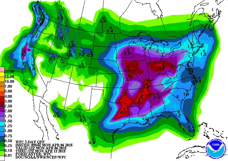
Re: Texas Spring-2015
Looks like a little rain is on the way for the eastern half of the state:

0 likes
-
Portastorm

- Storm2k Moderator

- Posts: 9955
- Age: 63
- Joined: Fri Jul 11, 2003 9:16 am
- Location: Round Rock, TX
- Contact:
Re: Texas Spring-2015
I'll tell you what worries me about the data chart Ntxw posted above ... I did a little research and the last summers which reflected similar ENSO values were 1953 and 1969. Both summers were hot and dry for Texas.
I would have figured ... El Nino ... active Southern jet ... severe weather, rains ... but apparently not. At least in those Nino summers.
I would have figured ... El Nino ... active Southern jet ... severe weather, rains ... but apparently not. At least in those Nino summers.
0 likes
Any forecasts under my name are to be taken with a grain of salt. Get your best forecasts from the National Weather Service and National Hurricane Center.
-
weatherdude1108
- Category 5
- Posts: 4228
- Joined: Tue Dec 13, 2011 1:04 pm
- Location: Northwest Austin/Cedar Park, TX
Rainstorm chances increasing hopefully.
FXUS64 KEWX 062021
AFDEWX
AREA FORECAST DISCUSSION
NATIONAL WEATHER SERVICE AUSTIN/SAN ANTONIO TX
321 PM CDT MON APR 6 2015
.SHORT TERM (TONIGHT THROUGH TUESDAY NIGHT)...
THE AFTERNOON VISIBLE SATELLITE IMAGERY STILL SHOWS PLENTY OF CLOUD
COVER IN PLACE ACROSS SOUTH CENTRAL TEXAS. THIS WILL LIMIT THE
OVERALL INSTABILITY AND LIKELY ALLOW THE MID-LEVEL CAPPING
INVERSION TO KEEP CONVECTION FROM DEVELOPING ACROSS MOST AREAS
THROUGH EARLY THIS EVENING. THE ONE EXCEPTION WILL BE OUT WEST
ACROSS THE SOUTHERN EDWARDS PLATEAU AND RIO GRANDE PLAINS. SPC
MESOANALYSIS SHOWS A NARROW AXIS OF SURFACE-BASED CAPE ALONG WITH
A LOCALIZED MIN IN CONVECTIVE INHIBITION. THE HRRR CONTINUES TO
SUGGEST THE POTENTIAL FOR SHOWERS AND THUNDERSTORMS TO DEVELOP
NEAR THE SERRANIAS DEL BURRO MOUNTAINS...THEN MOVE EAST INTO THE
RIO GRANDE PLAINS. IF CONVECTION DOES MANAGE TO DEVELOP...A STRONG
STORM OR TWO REMAINS POSSIBLE WITH HAIL AND GUSTY WINDS BEING THE
MAIN THREATS. WARM AND DRY CONDITIONS ARE EXPECTED ON TUESDAY AS
SOUTHWESTERLY FLOW ALOFT REMAINS INTACT.
&&
.LONG TERM (WEDNESDAY THROUGH MONDAY)...
ON WEDNESDAY...SOUTHWEST FLOW ALOFT WILL CONTINUE ACROSS THE REGION. AN
INCREASE IN MID-LEVEL SHORTWAVE ACTIVITY COULD LEAD TO AN UPTICK IN
PRECIPITATION CHANCES ACROSS MOST AREAS LATE WEDNESDAY INTO EARLY
THURSDAY. A FEW STRONG TO SEVERE STORMS REMAIN POSSIBLE ACROSS THE
SOUTHERN EDWARDS PLATEAU AND NORTHWEST HILL COUNTRY DURING THE LATE
AFTERNOON AND EVENING HOURS. FOR THE REMAINDER OF THE WORK WEEK AND
UPCOMING WEEKEND..SOUTHWEST FLOW ALOFT CONTINUES AND BECOMES
INCREASINGLY ACTIVE. WE/LL CONTINUE TO MENTION A LOW CHANCE FOR SHOWERS
AND THUNDERSTORMS ACROSS MOST AREAS. THE MEDIUM RANGE MODELS SHOW A
STRONGER UPPER LEVEL TROUGH MOVING IN FROM THE WEST THIS WEEKEND.
THERE ARE SOME TIMING DIFFERENCES AND WILL AWAIT ADDITIONAL MODEL
RUNS BEFORE ADJUSTING THE CURRENT FORECAST.
0 likes
The preceding post is NOT an official forecast, and should not be used as such. It is only the opinion of the poster and may or may not be backed by sound meteorological data. It is NOT endorsed by any professional institution including storm2k.org. For Official Information please refer to the NHC and NWS products.
Re: Texas Spring-2015
Portastorm wrote:I'll tell you what worries me about the data chart Ntxw posted above ... I did a little research and the last summers which reflected similar ENSO values were 1953 and 1969. Both summers were hot and dry for Texas.
I would have figured ... El Nino ... active Southern jet ... severe weather, rains ... but apparently not. At least in those Nino summers.
I never noticed that perhaps something to think about. One good thing though is this Nino is coupled with a raging +PDO Nino as opposed to those two events which were predominantly -PDO during their reign. This Nino so far has delivered (wetter than normal winter) since it began so good run so far, lets keep it up.
0 likes
The above post and any post by Ntxw is NOT an official forecast and should not be used as such. It is just the opinion of the poster and may or may not be backed by sound meteorological data. It is NOT endorsed by any professional institution including Storm2k. For official information, please refer to NWS products.
Help support Storm2K!
Help support Storm2K!
Return to “USA & Caribbean Weather”
Who is online
Users browsing this forum: No registered users and 125 guests