I uploaded a video of what the Southerly winds were like up here. Have any of you recorded what the Northerly winds are like down there. I've read comments here regarding how bad they are but have not seen any pics/videos of them.
Here's mine of the Northerly winds now https://www.youtube.com/watch?v=d3b1c2dsvvo (taken a day or two after we had the winds from the South). Its starts off while we are at the South edge of our protected valley and then we leave the city (we weren't silly enough to head out the other direction). This side tends not to get much moisture and is ranch land mainly...the division between ranch land and crop land is about right at our city limits.
Texas Spring 2013
Moderator: S2k Moderators
Forum rules

The posts in this forum are NOT official forecast and should not be used as such. They are just the opinion of the poster and may or may not be backed by sound meteorological data. They are NOT endorsed by any professional institution or STORM2K.
-
vbhoutex

- Storm2k Executive

- Posts: 29149
- Age: 74
- Joined: Wed Oct 09, 2002 11:31 pm
- Location: Cypress, TX
- Contact:
Re: Texas Spring 2013
Spring? What's that?  We won't be out of the 50's today with N winds gusting to 36mph. Feels like temp is 52f. Low this morning was 47f, with a low of 35f expected tomorrow and the next day. THIS IS NOT SPRING!!!!
We won't be out of the 50's today with N winds gusting to 36mph. Feels like temp is 52f. Low this morning was 47f, with a low of 35f expected tomorrow and the next day. THIS IS NOT SPRING!!!!
0 likes
Skywarn, C.E.R.T.
Please click below to donate to STORM2K to help with the expenses of keeping the site going:

Please click below to donate to STORM2K to help with the expenses of keeping the site going:
-
weatherdude1108
- Category 5

- Posts: 4228
- Joined: Tue Dec 13, 2011 1:04 pm
- Location: Northwest Austin/Cedar Park, TX
Well, how about that? 
URGENT - WEATHER MESSAGE
NATIONAL WEATHER SERVICE AUSTIN/SAN ANTONIO TX
349 PM CDT SUN MAR 24 2013
...FREEZE WARNING IN EFFECT FOR THE HILL COUNTRY AND LOW LYING
AREAS ALONG THE ESCARPMENT FROM 3 AM TO 10 AM CDT MONDAY...
.A COLD SURFACE HIGH PRESSURE WITH WELL BELOW AVERAGE TEMPERATURES
WILL SETTLE INTO SOUTH CENTRAL TEXAS TONIGHT. NEARLY EFFICIENT
RADIATIONAL COOLING DUE TO MOSTLY CLEAR SKIES...RAPIDLY DECREASING
NOCTURNAL WINDS AND LOW DEWPOINTS WINDS...IS EXPECTED TONIGHT.
FREEZING TEMPERATURES ARE EXPECTED IN MUCH OF THE HILL COUNTRY
WITH A FEW SPOTS HAVING A HARD FREEZE. ALONG THE ESCARPMENT AND
ALONG THE I-35 AND HIGHWAY 90 CORRIDORS...SOME LOW LYING SPOTS
WILL BE NEAR OR SLIGHTLY BELOW FREEZING.
TXZ171>173-184>192-203>206-250900-
/O.NEW.KEWX.FZ.W.0001.130325T0800Z-130325T1500Z/
LLANO-BURNET-WILLIAMSON-EDWARDS-REAL-KERR-BANDERA-GILLESPIE-
KENDALL-BLANCO-HAYS-TRAVIS-UVALDE-MEDINA-BEXAR-COMAL-
INCLUDING THE CITIES OF...LLANO...BURNET...GEORGETOWN...
ROCKSPRINGS...LEAKEY...KERRVILLE...BANDERA...FREDERICKSBURG...
BOERNE...BLANCO...SAN MARCOS...AUSTIN...UVALDE...HONDO...
SAN ANTONIO...NEW BRAUNFELS
349 PM CDT SUN MAR 24 2013
...FREEZE WARNING IN EFFECT FROM 3 AM TO 10 AM CDT MONDAY...
THE NATIONAL WEATHER SERVICE IN AUSTIN/SAN ANTONIO HAS ISSUED A
FREEZE WARNING...WHICH IS IN EFFECT FROM 3 AM TO 10 AM CDT
MONDAY.
* TEMPERATURE...LOWS 26 TO 31 DEGREES
* IMPACTS...THE COLD TEMPERATURES WILL CAUSE DAMAGE TO TENDER
PLANTS AND VEGETATION THAT MAY HAVE BEEN PLANTED DURING THE
EARLIER WARM WEATHER.
PRECAUTIONARY/PREPAREDNESS ACTIONS...
A FREEZE WARNING MEANS SUB-FREEZING TEMPERATURES ARE IMMINENT OR
HIGHLY LIKELY. THESE CONDITIONS WILL KILL CROPS AND OTHER
SENSITIVE VEGETATION.
0 likes
The preceding post is NOT an official forecast, and should not be used as such. It is only the opinion of the poster and may or may not be backed by sound meteorological data. It is NOT endorsed by any professional institution including storm2k.org. For Official Information please refer to the NHC and NWS products.
-
SaskatchewanScreamer
Re: Texas Spring 2013
vbhoutex wrote:Spring? What's that?
This winter truly was one of the old bugger's masterpieces.
0 likes

Cold here for late March this morning. A couple more chiller mornings before a good change at the end of this week. Nws FW did an amazing job this morning explaining the changes. HPC paints an inch+ of rain for the northeast quarter of Texas. The pattern is more typical of what we would expect with spring, squall lines forming off the high plains and Oklahoma effecting north Texas. Central Texas might struggle until the main system comes by though. Hard to pinpoint which day will be the wettest but on and off showers/rain might be expected end of this week for a few days.
0 likes
The above post and any post by Ntxw is NOT an official forecast and should not be used as such. It is just the opinion of the poster and may or may not be backed by sound meteorological data. It is NOT endorsed by any professional institution including Storm2k. For official information, please refer to NWS products.
Help support Storm2K!
-
Rgv20

- S2K Supporter

- Posts: 2466
- Age: 39
- Joined: Wed Jan 05, 2011 5:42 pm
- Location: Edinburg/McAllen Tx
From a High of 104 on Saturday to a Monday Morning Low of 49.....The difference was definitely felt! lol
0 likes
The following post is NOT an official forecast and should not be used as such. It is just the opinion of the poster and may or may not be backed by sound meteorological data. It is NOT endorsed by any professional institution including storm2k.org For Official Information please refer to the NHC and NWS products.
-
horselattitudesfarm

- Category 1

- Posts: 315
- Joined: Thu Jul 16, 2009 5:55 pm
- Location: Asheville, NC (formerly from Dallas, TX)
Re:
SaskatchewanScreamer wrote:I uploaded a video of what the Southerly winds were like up here. Have any of you recorded what the Northerly winds are like down there. I've read comments here regarding how bad they are but have not seen any pics/videos of them.
Here's mine of the Northerly winds now https://www.youtube.com/watch?v=d3b1c2dsvvo (taken a day or two after we had the winds from the South). Its starts off while we are at the South edge of our protected valley and then we leave the city (we weren't silly enough to head out the other direction). This side tends not to get much moisture and is ranch land mainly...the division between ranch land and crop land is about right at our city limits.
They're the same as southerly winds, except the dust blows from the other direction
0 likes
-
horselattitudesfarm
- Category 1
- Posts: 315
- Joined: Thu Jul 16, 2009 5:55 pm
- Location: Asheville, NC (formerly from Dallas, TX)
Another fun read from Gary McManus from Oklahoma. I post it because Oklahoma weather affects our weather here in North Texas and seems to be similar to what we are getting lately, and also because it might entertain some of you. It appears that the magical meteorological demarcation line of the Red River seems to have broken down as we are all now in the same boat, or maybe 2 different lifeboats from the same sinking ship. Oh, wait, there is no water to float the boats on at the lakes around here. 
(You can register to get the newsletter using the address at the bottom)
MESONET TICKER ... MESONET TICKER ... MESONET TICKER ... MESONET TICKER ...
March 25, 2013 March 25, 2013 March 25, 2013 March 25, 2013
"A doozy of a dud
Spring break was broke, at least from my point of view. It was cold, gray, and cold. The gray would have been okay had it actually rained enough to matter, given our drought situation, but the 3-4 days of precipitation turned out to be 3-4 days of a cold drizzle for many locations. Heck, I'll go back seven days to try and make it look better!
http://ticker.mesonet.org/archive/20130 ... .168hr.png
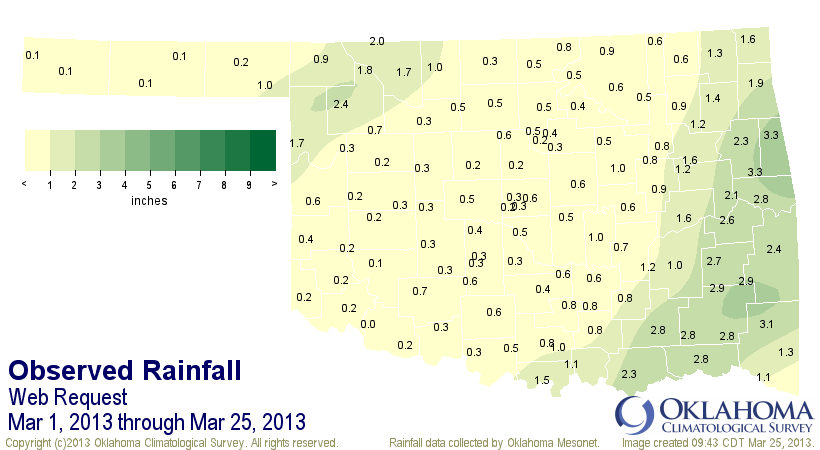
A pitiful showing by Mother Nature last week to be sure, unless you live on those places under the green regime. Some localized areas in southeastern Oklahoma received more than ain inch, it appears, but most of the state got the lesser end of the stick. Don't look now, but we're on another of those streaks we don't like to see. It has now been close to a month (closer if that month is February) since parts of the state have seen at least a quarter-inch of liquid precip in a day.
http://ticker.mesonet.org/archive/20130 ... erinch.png
Kenton is having a mighty "guffaw" at that type of whining, since they'll be up to 101 days after today. The tenth of an inch map looks a bit better for some areas, but again, Kenton will be at 101 consecutive days after today.
http://ticker.mesonet.org/archive/20130 ... thinch.png
So after our wonderfully wet February (for most), March has landed with a thud thus far. At least for folks not living in Ellis, Woodward and Woods counties.
The rain and snow this weekend brought the statewide average for the month to
0.95 inches, 1.53 inches below normal, and now ranked as the 18th driest March
1-25 on record.
http://ticker.mesonet.org/archive/20130 ... 5-tots.png
http://ticker.mesonet.org/archive/20130 ... 25-pct.png
That's the story of the drought over the last 2.5 years ... one step forward and two steps back. One saving grace has been the below normal temperatures.
That has both kept the vegetation at bay, easing the stress on the replenished soil moisture we received over the previous two months, but also kept the evaporation down. That also helps to keep that soil moisture in place while the rains have been absent, and also slows the evaporation from some of the state's beleaguered reservoirs.
With a March 1-24 statewide average temperature from the Mesonet estimated at
46.6 degrees, that drops the month to 2.3 degrees below normal. Average highs have been 58.8 degrees (normal of 61.5) and average lows have been 34.4 degrees (normal of 36.2).
Attention now turns to later this week for our next storm system, with hopes it won't crash and burn like the last. This one will come with some heat and a chance of storms, so with a bit more convective precipitation, maybe we can push those amounts up a bit. The latest 7-day rain forecast from the WPC (formerly known as HPC) is pinging us with a half-inch to over 2 inches across the state from the late-week storm.
http://ticker.mesonet.org/archive/20130 ... y-rain.gif
That type of rain would go a long way in saving our dud of a March thus far. The first problem is getting it to pan out, of course. Maybe this is the start of many more forward steps with fewer backwards steps?
Hey, it's a drought! This is how they work. "
Gary McManus
Associate State Climatologist
Oklahoma Climatological Survey
(405) 325-2253
gmcmanus@mesonet.org
March 25 in Mesonet History*:
Record Maximum 93 F at WOOD in 1998
Record Minimum 18 F at BOIS in 2010
Record Rainfall 2.59" at CAMA in 1995
* - Mesonet History = since 1994
(You can register to get the newsletter using the address at the bottom)
MESONET TICKER ... MESONET TICKER ... MESONET TICKER ... MESONET TICKER ...
March 25, 2013 March 25, 2013 March 25, 2013 March 25, 2013
"A doozy of a dud
Spring break was broke, at least from my point of view. It was cold, gray, and cold. The gray would have been okay had it actually rained enough to matter, given our drought situation, but the 3-4 days of precipitation turned out to be 3-4 days of a cold drizzle for many locations. Heck, I'll go back seven days to try and make it look better!
http://ticker.mesonet.org/archive/20130 ... .168hr.png
A pitiful showing by Mother Nature last week to be sure, unless you live on those places under the green regime. Some localized areas in southeastern Oklahoma received more than ain inch, it appears, but most of the state got the lesser end of the stick. Don't look now, but we're on another of those streaks we don't like to see. It has now been close to a month (closer if that month is February) since parts of the state have seen at least a quarter-inch of liquid precip in a day.
http://ticker.mesonet.org/archive/20130 ... erinch.png
Kenton is having a mighty "guffaw" at that type of whining, since they'll be up to 101 days after today. The tenth of an inch map looks a bit better for some areas, but again, Kenton will be at 101 consecutive days after today.
http://ticker.mesonet.org/archive/20130 ... thinch.png
So after our wonderfully wet February (for most), March has landed with a thud thus far. At least for folks not living in Ellis, Woodward and Woods counties.
The rain and snow this weekend brought the statewide average for the month to
0.95 inches, 1.53 inches below normal, and now ranked as the 18th driest March
1-25 on record.
http://ticker.mesonet.org/archive/20130 ... 5-tots.png
http://ticker.mesonet.org/archive/20130 ... 25-pct.png
That's the story of the drought over the last 2.5 years ... one step forward and two steps back. One saving grace has been the below normal temperatures.
That has both kept the vegetation at bay, easing the stress on the replenished soil moisture we received over the previous two months, but also kept the evaporation down. That also helps to keep that soil moisture in place while the rains have been absent, and also slows the evaporation from some of the state's beleaguered reservoirs.
With a March 1-24 statewide average temperature from the Mesonet estimated at
46.6 degrees, that drops the month to 2.3 degrees below normal. Average highs have been 58.8 degrees (normal of 61.5) and average lows have been 34.4 degrees (normal of 36.2).
Attention now turns to later this week for our next storm system, with hopes it won't crash and burn like the last. This one will come with some heat and a chance of storms, so with a bit more convective precipitation, maybe we can push those amounts up a bit. The latest 7-day rain forecast from the WPC (formerly known as HPC) is pinging us with a half-inch to over 2 inches across the state from the late-week storm.
http://ticker.mesonet.org/archive/20130 ... y-rain.gif
That type of rain would go a long way in saving our dud of a March thus far. The first problem is getting it to pan out, of course. Maybe this is the start of many more forward steps with fewer backwards steps?
Hey, it's a drought! This is how they work. "
Gary McManus
Associate State Climatologist
Oklahoma Climatological Survey
(405) 325-2253
gmcmanus@mesonet.org
March 25 in Mesonet History*:
Record Maximum 93 F at WOOD in 1998
Record Minimum 18 F at BOIS in 2010
Record Rainfall 2.59" at CAMA in 1995
* - Mesonet History = since 1994
0 likes
-
weatherdude1108
- Category 5
- Posts: 4228
- Joined: Tue Dec 13, 2011 1:04 pm
- Location: Northwest Austin/Cedar Park, TX
Not sure if this should go in the Winter or Spring thread, so I'll put it in Spring since Winter temps are winding down for the season. Our last blast of Winter is not going down without a fight though! Maybe we'll get some more storm action (in the form of rain) next week(?) 

AREA FORECAST DISCUSSION
NATIONAL WEATHER SERVICE AUSTIN/SAN ANTONIO TX
350 PM CDT MON MAR 25 2013
.SHORT TERM (TONIGHT THROUGH TUESDAY NIGHT)...
COLD SURFACE HIGH PRESSURE WITH WELL BELOW AVERAGE TEMPERATURES
WILL SETTLE INTO SOUTH CENTRAL TEXAS TONIGHT. NEARLY EFFICIENT
RADIATIONAL COOLING DUE TO MOSTLY CLEAR SKIES...LIGHT WINDS AND
LOW DEWPOINTS...IS EXPECTED TONIGHT. FREEZING TEMPERATURES ARE
EXPECTED IN MUCH OF THE HILL COUNTRY WITH SOME SPOTS HAVING A
HARD FREEZE. ALONG THE ESCARPMENT AND BETWEEN THE I-35 AND I-10
CORRIDORS EAST OF SAN ANTONIO...SOME LOW LYING SPOTS WILL BE
SLIGHTLY BELOW FREEZING. ELSEWHERE..IT WILL BE JUST ABOVE
FREEZING. HAVE ISSUED A FREEZE WARNING FOR THE HILL COUNTRY AND
PARTS OF SOUTH CENTRAL TEXAS FOR EARLY TUESDAY MORNING. THE FOUR
CLIMATE SITES MAY APPROACH RECORD LOWS FOR TUESDAY THE 26TH. THE
RECORDS ARE IN THE CLIMATE SECTION BELOW. SURFACE HIGH MOVES OFF
TO THE EAST ON TUESDAY WITH SOUTHERLY WINDS RETURNING. TUESDAY AND
TUESDAY NIGHT REMAIN WELL BELOW AVERAGE AS LOWER LEVEL MOISTURE IS
SLOW TO RETURN.
&&
.LONG TERM (WEDNESDAY THROUGH MONDAY)...
AS THE SURFACE HIGH CONTINUES TO MOVE OFF TO THE EAST WEDNESDAY
SOUTHERLY LOWER LEVEL FLOW BRINGS A WARMING TREND WITH INCREASING
MOISTURE WEDNESDAY THROUGH FRIDAY. WEAK DISTURBANCES IN THE ZONAL
FLOW ALOFT WILL BRING SLIGHT CHANCES OF SHOWERS THURSDAY INTO
FRIDAY. TEMPERATURES RISE TO NEAR AVERAGE BY FRIDAY. DEEPER
MOISTURE WITH ADDITIONAL UPPER LEVEL DISTURBANCES IN THE ZONAL
FLOW ALOFT WILL LEAD TO LOW CHANCES OF SHOWERS AND THUNDERSTORMS
THIS WEEKEND INTO EARLY NEXT WEEK. TEMPERATURES WILL BE SLIGHTLY
ABOVE AVERAGE NEXT WEEKEND INTO EARLY NEXT WEEK.
OUTLOOK FOR NEXT TUESDAY SHOWS AN UPPER LEVEL TROUGH AND PACIFIC
FRONT MOVING ACROSS THE PLAINS WITH A CHANCES OF SHOWERS AND
THUNDERSTORMS. IT IS TOO EARLY TO TELL...HOWEVER SOME STRONG
STORMS MAY BECOME POSSIBLE.
Maybe we'll get some more storm action (in the form of rain) next week(?) AREA FORECAST DISCUSSION
NATIONAL WEATHER SERVICE AUSTIN/SAN ANTONIO TX
350 PM CDT MON MAR 25 2013
.SHORT TERM (TONIGHT THROUGH TUESDAY NIGHT)...
COLD SURFACE HIGH PRESSURE WITH WELL BELOW AVERAGE TEMPERATURES
WILL SETTLE INTO SOUTH CENTRAL TEXAS TONIGHT. NEARLY EFFICIENT
RADIATIONAL COOLING DUE TO MOSTLY CLEAR SKIES...LIGHT WINDS AND
LOW DEWPOINTS...IS EXPECTED TONIGHT. FREEZING TEMPERATURES ARE
EXPECTED IN MUCH OF THE HILL COUNTRY WITH SOME SPOTS HAVING A
HARD FREEZE. ALONG THE ESCARPMENT AND BETWEEN THE I-35 AND I-10
CORRIDORS EAST OF SAN ANTONIO...SOME LOW LYING SPOTS WILL BE
SLIGHTLY BELOW FREEZING. ELSEWHERE..IT WILL BE JUST ABOVE
FREEZING. HAVE ISSUED A FREEZE WARNING FOR THE HILL COUNTRY AND
PARTS OF SOUTH CENTRAL TEXAS FOR EARLY TUESDAY MORNING. THE FOUR
CLIMATE SITES MAY APPROACH RECORD LOWS FOR TUESDAY THE 26TH. THE
RECORDS ARE IN THE CLIMATE SECTION BELOW. SURFACE HIGH MOVES OFF
TO THE EAST ON TUESDAY WITH SOUTHERLY WINDS RETURNING. TUESDAY AND
TUESDAY NIGHT REMAIN WELL BELOW AVERAGE AS LOWER LEVEL MOISTURE IS
SLOW TO RETURN.
&&
.LONG TERM (WEDNESDAY THROUGH MONDAY)...
AS THE SURFACE HIGH CONTINUES TO MOVE OFF TO THE EAST WEDNESDAY
SOUTHERLY LOWER LEVEL FLOW BRINGS A WARMING TREND WITH INCREASING
MOISTURE WEDNESDAY THROUGH FRIDAY. WEAK DISTURBANCES IN THE ZONAL
FLOW ALOFT WILL BRING SLIGHT CHANCES OF SHOWERS THURSDAY INTO
FRIDAY. TEMPERATURES RISE TO NEAR AVERAGE BY FRIDAY. DEEPER
MOISTURE WITH ADDITIONAL UPPER LEVEL DISTURBANCES IN THE ZONAL
FLOW ALOFT WILL LEAD TO LOW CHANCES OF SHOWERS AND THUNDERSTORMS
THIS WEEKEND INTO EARLY NEXT WEEK. TEMPERATURES WILL BE SLIGHTLY
ABOVE AVERAGE NEXT WEEKEND INTO EARLY NEXT WEEK.
OUTLOOK FOR NEXT TUESDAY SHOWS AN UPPER LEVEL TROUGH AND PACIFIC
FRONT MOVING ACROSS THE PLAINS WITH A CHANCES OF SHOWERS AND
THUNDERSTORMS. IT IS TOO EARLY TO TELL...HOWEVER SOME STRONG
STORMS MAY BECOME POSSIBLE.
0 likes
The preceding post is NOT an official forecast, and should not be used as such. It is only the opinion of the poster and may or may not be backed by sound meteorological data. It is NOT endorsed by any professional institution including storm2k.org. For Official Information please refer to the NHC and NWS products.

0 likes
The above post and any post by Ntxw is NOT an official forecast and should not be used as such. It is just the opinion of the poster and may or may not be backed by sound meteorological data. It is NOT endorsed by any professional institution including Storm2k. For official information, please refer to NWS products.
Help support Storm2K!
Help support Storm2K!
-
South Texas Storms

- Professional-Met

- Posts: 4259
- Joined: Thu Jun 24, 2010 12:28 am
- Location: Houston, TX
Re: Texas Spring 2013
Yeah Ntxw, the next 1 to 2 weeks looks pretty wet across Texas. Today's 12z Euro run is showing rainfall totals over 1 inch for a large part of the state throughout the next 10 days. I really hope it verifies!
It looks like we will have a few chances of rain this weekend as little disturbances ahead of the main system kick out across our area. Like you said, the main system could give mostly the northern half of Texas some heavy rain and severe weather in about 8 days.
0 likes
-
Portastorm

- Storm2k Moderator

- Posts: 9955
- Age: 63
- Joined: Fri Jul 11, 2003 9:16 am
- Location: Round Rock, TX
- Contact:
Re: Texas Spring 2013
If only we could have had this set-up two months ... AO in the depths, Texas temps averaging 15-20 degrees below normal with another major blast of cold air scheduled for next week. 
0 likes
Any forecasts under my name are to be taken with a grain of salt. Get your best forecasts from the National Weather Service and National Hurricane Center.
-
vbhoutex
- Storm2k Executive
- Posts: 29149
- Age: 74
- Joined: Wed Oct 09, 2002 11:31 pm
- Location: Cypress, TX
- Contact:
Re: Texas Spring 2013
Portastorm wrote:If only we could have had this set-up two months ... AO in the depths, Texas temps averaging 15-20 degrees below normal with another major blast of cold air scheduled for next week.
I like the way you think!! Too bad it is a fantasy!
0 likes
Skywarn, C.E.R.T.
Please click below to donate to STORM2K to help with the expenses of keeping the site going:
Please click below to donate to STORM2K to help with the expenses of keeping the site going:
-
South Texas Storms
- Professional-Met
- Posts: 4259
- Joined: Thu Jun 24, 2010 12:28 am
- Location: Houston, TX
Re: Texas Spring 2013
vbhoutex wrote:Portastorm wrote:If only we could have had this set-up two months ... AO in the depths, Texas temps averaging 15-20 degrees below normal with another major blast of cold air scheduled for next week.
I like the way you think!! Too bad it is a fantasy!Even with the mention of rain in the forecast I am not liking the trend I still see, at least here in SE TX since it shows maybe 1/2" here in the next 7 days. Right now it looks like I will close out the month with just over a half inch for the month unless the 20%-30% chance this weekend produces a surprise.
I would be very happy with .50 inch! In drought we need to be thankful for every drop of rain we get. .50 inch of rain would be very appreciated in my backyard!
0 likes
-
vbhoutex
- Storm2k Executive
- Posts: 29149
- Age: 74
- Joined: Wed Oct 09, 2002 11:31 pm
- Location: Cypress, TX
- Contact:
Re: Texas Spring 2013
South Texas Storms wrote:vbhoutex wrote:Portastorm wrote:If only we could have had this set-up two months ... AO in the depths, Texas temps averaging 15-20 degrees below normal with another major blast of cold air scheduled for next week.
I like the way you think!! Too bad it is a fantasy!
I would be very happy with .50 inch! In drought we need to be thankful for every drop of rain we get. .50 inch of rain would be very appreciated in my backyard!
I'd be appreciative of a drop, much less 0.50"!! I will believe it when I see it with the current trend of a basically continuous cap over our area. Does not bode well for Spring(if we have one) or Summer. Saw this same basic pattern in 2011.
0 likes
Skywarn, C.E.R.T.
Please click below to donate to STORM2K to help with the expenses of keeping the site going:
Please click below to donate to STORM2K to help with the expenses of keeping the site going:

Re: Texas Spring 2013
Shock and awe, from the FWD AFD:
WITH WEST/SOUTHWEST LOW LEVEL FLOW OFF THE SURFACE...WARM
TEMPERATURES IN THE 700-800 MB LAYER WILL BE ADVECTED OVER THE
AREA. THIS LAYER OF WARM AIR WILL SERVE AS A CAP AND PREVENT
PRECIPITATION FROM DEVELOPING OVER THE REGION WITHOUT SUBSTANTIAL
LIFT. HAVE REMOVED POPS ON THURSDAY DUE TO THE INVERSION. THERE IS A
SMALL CHANCE OF A FEW SHOWERS UNDERNEATH THE CAP THURSDAY...BUT
MOISTURE DEPTH IS LACKING AND WITH ONLY A MODEST 20 KNOTS OF
FLOW...THINK THE CHANCES WILL BE TOO LOW TO WARRANT 20 POPS.
.....
FOR THE WEEKEND...THE UPPER LOW THAT IS CURRENTLY OVER ALASKA WILL
DEEPEN AND MOVE SOUTHEAST INTO THE NORTHERN PLAINS BY SUNDAY. THIS
WILL BRING A COLD FRONT INTO NORTH TEXAS SUNDAY MORNING. AHEAD OF
THE FRONT...A FEW SHOWERS AND THUNDERSTORMS WILL BE
POSSIBLE...MAINLY IN THE EASTERN ZONES...WHERE THE CAP IS WEAKEST
AND MOISTURE IS BEST
Cap Cap Cap Cap Cap. I hate you Cap.
0 likes
-
weatherdude1108
- Category 5
- Posts: 4228
- Joined: Tue Dec 13, 2011 1:04 pm
- Location: Northwest Austin/Cedar Park, TX
Ugh.
Guess that's what we get for living so close to the Chihuahuan Desert.
http://www.white-sands-new-mexico.com/i ... desert.gif
0 likes
The preceding post is NOT an official forecast, and should not be used as such. It is only the opinion of the poster and may or may not be backed by sound meteorological data. It is NOT endorsed by any professional institution including storm2k.org. For Official Information please refer to the NHC and NWS products.
-
South Texas Storms
- Professional-Met
- Posts: 4259
- Joined: Thu Jun 24, 2010 12:28 am
- Location: Houston, TX
Re: Texas Spring 2013
I freakin hate the cap too but we weren't expected to get much rain this weekend all along. Our best chance for heavy rain in quite some time is still expected to arrive in about 7 to 8 days.
0 likes
-
wxman57

- Moderator-Pro Met

- Posts: 23175
- Age: 68
- Joined: Sat Jun 21, 2003 8:06 pm
- Location: Houston, TX (southwest)
Re:
SaskatchewanScreamer wrote:I uploaded a video of what the Southerly winds were like up here. Have any of you recorded what the Northerly winds are like down there. I've read comments here regarding how bad they are but have not seen any pics/videos of them.
Here's mine of the Northerly winds now https://www.youtube.com/watch?v=d3b1c2dsvvo (taken a day or two after we had the winds from the South). Its starts off while we are at the South edge of our protected valley and then we leave the city (we weren't silly enough to head out the other direction). This side tends not to get much moisture and is ranch land mainly...the division between ranch land and crop land is about right at our city limits.
Here's my video of the gusty northerly winds we had in Houston last weekend. Highs only in the upper 50s (near 15C). It's taken from my front porch. Winter (early spring) in Houston is a bit different from winter in Moose Jaw...
http://home.comcast.net/~cgh57/wind.mov
0 likes
-
SaskatchewanScreamer
Re: Re:
wxman57 wrote:SaskatchewanScreamer wrote:I uploaded a video of what the Southerly winds were like up here. Have any of you recorded what the Northerly winds are like down there. I've read comments here regarding how bad they are but have not seen any pics/videos of them.
Here's mine of the Northerly winds now https://www.youtube.com/watch?v=d3b1c2dsvvo (taken a day or two after we had the winds from the South). Its starts off while we are at the South edge of our protected valley and then we leave the city (we weren't silly enough to head out the other direction). This side tends not to get much moisture and is ranch land mainly...the division between ranch land and crop land is about right at our city limits.
Here's my video of the gusty northerly winds we had in Houston last weekend. Highs only in the upper 50s (near 15C). It's taken from my front porch. Winter (early spring) in Houston is a bit different from winter in Moose Jaw...
http://home.comcast.net/~cgh57/wind.mov
 True winter suffering to be seen there!!!!!!!!!!!!!!!!!!!!!
That is in no way......shape......or.......form WINTER!!! You fellows have had your brain cells fried for waaaaaaaaaaaaaaaaaaaaaay tooooooooooooo loooooooooooooooooooooong if you can say with a straight face that that video up
You need different names for your
 seasons!
Last edited by SaskatchewanScreamer on Wed Mar 27, 2013 8:41 pm, edited 1 time in total.
0 likes
Return to “USA & Caribbean Weather”
Who is online
Users browsing this forum: No registered users and 143 guests