Hypercane_Kyle wrote:Here in Cape Canaveral, we got an absolutely insane amount of rain yesterday. Lots of flooding.
Well thank you very little
Moderator: S2k Moderators

Hypercane_Kyle wrote:Here in Cape Canaveral, we got an absolutely insane amount of rain yesterday. Lots of flooding.
psyclone wrote:Dodged another 80% and 70% rain odds...at least the rain chances are gone now. Strong front is about a week out and right on schedule as normal to somewhat below normal temps are showing on the CPC outlooks. We might get some sustained low dewpoint, refreshing air. That will drive a stake through hurricane season for us if that happens and things are tilting that way.
Ianswfl wrote:psyclone wrote:Dodged another 80% and 70% rain odds...at least the rain chances are gone now. Strong front is about a week out and right on schedule as normal to somewhat below normal temps are showing on the CPC outlooks. We might get some sustained low dewpoint, refreshing air. That will drive a stake through hurricane season for us if that happens and things are tilting that way.
Well, you have storms like Eta and hurricane kate that hit after cold fronts. What says we don't get something like a Kate, Eta, or Nicole in November even after we've had some fronts?
If something forms in the Carribean it could get pushed up our way still. However it would be not as strong since no more 90 degree waters.
Would you say Kate was like a once in 150 year storm?
Remember ft. Myers get hit by a tropical storm on December 1st. Was thought to be a min hurricane but hurdat revised it
psyclone wrote:Ianswfl wrote:psyclone wrote:Dodged another 80% and 70% rain odds...at least the rain chances are gone now. Strong front is about a week out and right on schedule as normal to somewhat below normal temps are showing on the CPC outlooks. We might get some sustained low dewpoint, refreshing air. That will drive a stake through hurricane season for us if that happens and things are tilting that way.
Well, you have storms like Eta and hurricane kate that hit after cold fronts. What says we don't get something like a Kate, Eta, or Nicole in November even after we've had some fronts?
If something forms in the Carribean it could get pushed up our way still. However it would be not as strong since no more 90 degree waters.
Would you say Kate was like a once in 150 year storm?
Remember ft. Myers get hit by a tropical storm on December 1st. Was thought to be a min hurricane but hurdat revised it
Kate was highly anomalous. That's why it's so memorable. When you have to reach back decades for an example...it means it usually doesn't happen. If we get persistent dry air flooding the field...which appears to be an increasing possibility...it's curtains for cane season. Time will tell...but most years we sneak through and if the pattern becomes hostile...that's another big thumb on the scale of that outcome.
psyclone wrote:I'm bullish on lots of winter squall lines...although the 2015 Nino did not deliver to the extent expected. This winter season could be much more interesting than usual. Time will tell but we need extra water in west central FL after this failed rainy season


Ianswfl wrote:Front looks like it will be weaker and stall! Just makes it past me but seems to stall over south FL with hardly change in temps for Miami. Will keep the waters from cooling as bad.
FlaWeatherDude wrote:Ianswfl wrote:Front looks like it will be weaker and stall! Just makes it past me but seems to stall over south FL with hardly change in temps for Miami. Will keep the waters from cooling as bad.
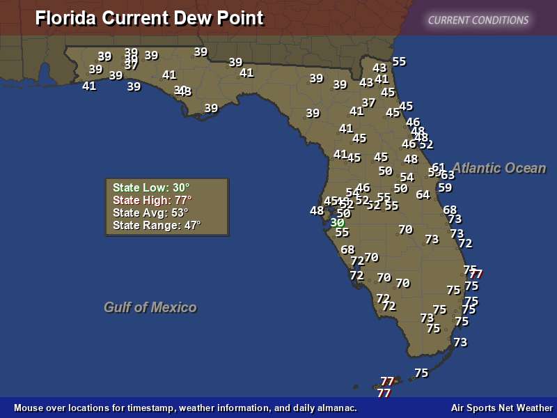
Yeah looks like the 60 degree dewpoint isotope will barely make it much south of Fort Myers/Lake Oklachobee with refreshing dewpoints(30's-50's) staying across all of Central and North Florida.
I think 99E will merge with a S/W late week that'll carve a deeper trough by the weekend. This should drive a stronger front through south Florida by next Sunday baring any changes.
Ianswfl wrote:FlaWeatherDude wrote:Ianswfl wrote:Front looks like it will be weaker and stall! Just makes it past me but seems to stall over south FL with hardly change in temps for Miami. Will keep the waters from cooling as bad.
Yeah looks like the 60 degree dewpoint isotope will barely make it much south of Fort Myers/Lake Oklachobee with refreshing dewpoints(30's-50's) staying across all of Central and North Florida.
I think 99E will merge with a S/W late week that'll carve a deeper trough by the weekend. This should drive a stronger front through south Florida by next Sunday baring any changes.
Do you think maybe we get something sub tropical on it? Simulated euro Satellite looks like something sub tropical forms along it. Hybrid, sloppy system.
FlaWeatherDude wrote:Ianswfl wrote:FlaWeatherDude wrote:
Yeah looks like the 60 degree dewpoint isotope will barely make it much south of Fort Myers/Lake Oklachobee with refreshing dewpoints(30's-50's) staying across all of Central and North Florida.
I think 99E will merge with a S/W late week that'll carve a deeper trough by the weekend. This should drive a stronger front through south Florida by next Sunday baring any changes.
Do you think maybe we get something sub tropical on it? Simulated euro Satellite looks like something sub tropical forms along it. Hybrid, sloppy system.
Not enough to be classified as a subtropical storm but definately will send juice our way Wed-Fri next week!


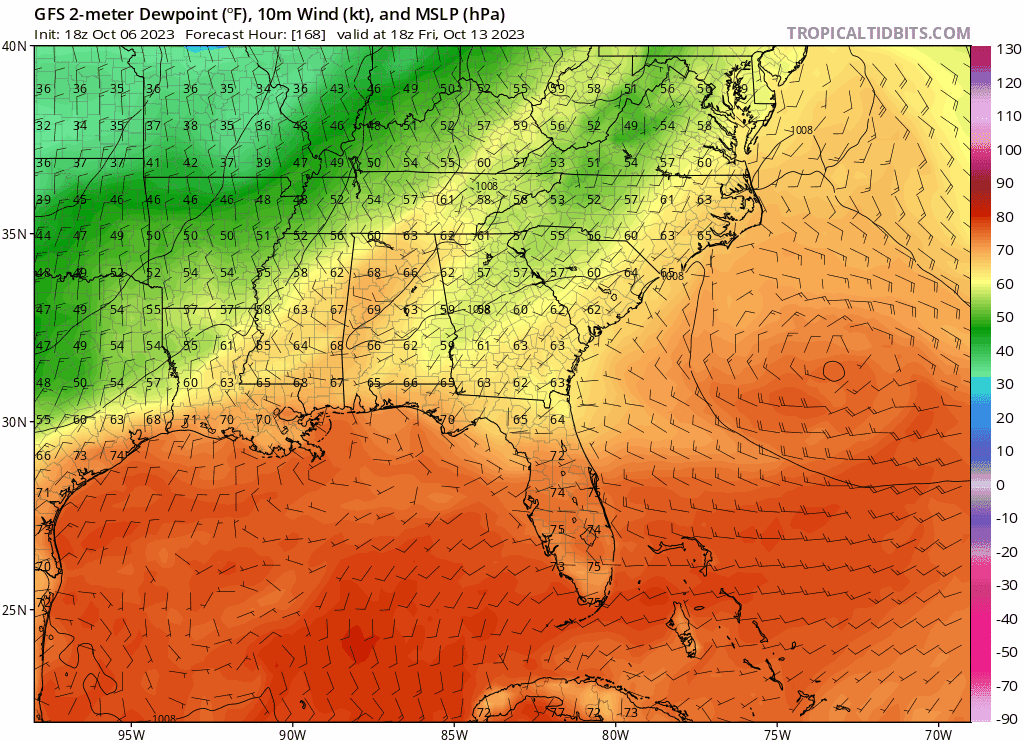
gatorcane wrote:Looks like the front next weekend means business. Here is the GFS dewpoint animation. The Euro also shows the front clearing Florida. That said, still long-range:
https://i.postimg.cc/vBdNBFRN/gfs-Td2m-seus-fh168-234.gif
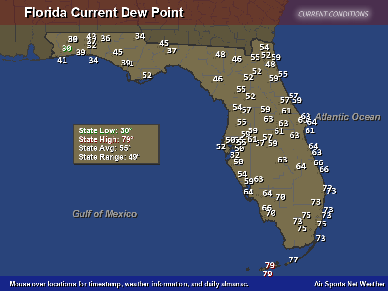
Plenty of moisture and SW flow for sofla, the very wet 2023 continues.gatorcane wrote:Lower dew points have invaded down into the Central Florida peninsula.
Return to “USA & Caribbean Weather”
Users browsing this forum: No registered users and 44 guests