Page 84 of 85
Re: Texas Fall-2014
Posted: Tue Nov 25, 2014 2:09 pm
by CaptinCrunch
srainhoutx wrote:It was an epic November with regard to super Typhoon Nuri transitioning to an exratropical Super Storm that basically changed the entire November pattern on a planetary scale particularly the Northern Hemisphere. The October Eurasia snow led the way with the teleconnection indices responding and Nuri flipped the building cold over Eurasia/Siberia and delivered a record breaking extreme shot of cold air in mid-November across much of the Lower 48. Enjoy the warmup while it lasts. It was sort of fitting to end the Fall discussions with an epic Arctic Outbreak that actually continues today into tomorrow and Thanksgiving to our E as the pattern of a deep Central/Eastern trough pattern finally relaxes. Happy Thanksgiving Everyone!
srainhoutx you are correct about Nuri, it did change the global weather pattern and in the process gave North America I brief taste of Winter. Now that the global weather pattern has recovered things are looking about normal for early December. With El Nino coming along nicely and the cold pool sitting across upper Canada it's only a matter of time before the next arctic plunge drives south and we are talking about winter precip across north Texas. Happy Thanksgiving to all.....

Posted: Tue Nov 25, 2014 4:56 pm
by weatherdude1108
Looking forward to an ideal day of travel (weatherwise) tomorrow to southeast Texas. Not looking forward to dodging several million of my closest compadres en route, but very much looking forward to being thankful for the food and treats.

Happy Thanksgiving everyone!!
Posted: Tue Nov 25, 2014 8:32 pm
by gatorcane
A look at the cold air building over Canada...


Posted: Tue Nov 25, 2014 9:12 pm
by Texas Snowman

Good weather to ride a bicycle in!

Bring it on - we ain't skeered!!!
Posted: Tue Nov 25, 2014 9:53 pm
by Nairobi
Interesting study about the effects of recurving typhoons on the extratropical flow pattern in the northern Pacific:
Although prior studies have established that the extratropical flow pattern often amplifies downstream of recurving tropical cyclones (TCs), the extratropical flow response to recurving TCs has not to the authors' knowledge been systematically examined from a climatological perspective. In this study, a climatology of the extratropical flow response to recurving western North Pacific TCs is constructed from 292 cases of TC recurvature during 1979–2009. The extratropical flow response to TC recurvature is evaluated based on a time-lagged composite time series of an index of the North Pacific meridional flow surrounding TC recurvature. Similar time series are constructed for recurving TCs stratified by characteristics of the large-scale flow pattern, the TC, and the phasing between the TC and the extratropical flow to assess factors influencing the extratropical flow response to TC recurvature. Results reveal that following TC recurvature, significantly amplified flow develops over the North Pacific and persists for ~4 days. The tendency for significantly amplified North Pacific flow to develop following TC recurvature is sensitive to the strength of the TC–extratropical flow interaction (the phasing between the TC and the extratropical flow), which is based on the negative potential vorticity advection by the divergent outflow of the TC. In contrast, the tendency for significantly amplified North Pacific flow to develop following TC recurvature is relatively insensitive to the intensity or size of the recurving TC, or whether it subsequently reintensifies after becoming extratropical.
Source:
http://journals.ametsoc.org/doi/abs/10. ... 12-00257.1
Posted: Tue Nov 25, 2014 10:07 pm
by Nairobi
Not all recurving typhoons have a big impact on the downstream flow:
Albeit recurving and undergoing ET, the downstream impact of Typhoon Jangmi in September 2008 ... was weak. In this study, we explore the physical processes inhibiting the reintensification of Jangmi and governing the forecast uncertainty during ET. The focus is on the relative contribution of the TC and the midlatitude flow. ... Jangmi is located south of and in phase with a midlatitude trough. Jangmi does not couple with the region favourable for reintensification ahead of the trough and subsequently decays. Instead, a weak frontal wave-like cyclone develops. The role of the phasing of Typhoon Jangmi and the midlatitude Rossby wave pattern is tested in sensitivity experiments with the COSMO model in which Jangmi has been relocated. The simulations reveal two contrasting groups of scenarios. The first group reflects the weak actual ET and subsequent decay accompanied by a broad ridge over the Pacific. The second group is characterized by a strong ET with extratropical reintensification, the triggering of a pronounced Rossby wave train and downstream cyclogenesis. The displacement of Jangmi's initial position in the two contrasting groups is less than 1.25° (130 km). In the frame moving with the environmental background flow a critical bifurcation point for the track of Jangmi exists. The relative position to this bifurcation point determines whether Jangmi decays or reintensifies and triggers a Rossby wave train. A simple discrimination parameter is derived that allows for classifying the scenarios....
Source:
http://onlinelibrary.wiley.com/doi/10.1 ... ated=false
Re:
Posted: Wed Nov 26, 2014 8:49 am
by wxman57
Texas Snowman wrote::uarrow: Good weather to ride a bicycle in!
Bring it on - we ain't skeered!!!
I'm having some success in keeping that nasty cold way up north. Should be close to 70 here today. Cool, but sunny. Heading out on the bikes late this morning when it warms up a bit.
Posted: Wed Nov 26, 2014 6:28 pm
by Texas Snowman
You do that Mr. Wxman 57. Go ahead, enjoy these days of warmth.
Kind of like the turkey that is enjoying the Wednesday before Thanksgiving!
Seriously, hope you and those dear to you have a wonderful Thanksgiving Day holiday!!!
Re: Re:
Posted: Thu Nov 27, 2014 9:36 am
by Tireman4
wxman57 wrote:Texas Snowman wrote::uarrow: Good weather to ride a bicycle in!
Bring it on - we ain't skeered!!!
I'm having some success in keeping that nasty cold way up north. Should be close to 70 here today. Cool, but sunny. Heading out on the bikes late this morning when it warms up a bit.
Happy Thanksgiving Wxman 57. I will get both biking and running in..

. The cold air will come sir. And come it shall.
Posted: Thu Nov 27, 2014 9:50 am
by KatDaddy
Happy Thanksgiving! Perfect SE TX weather but a little chilly for for me.

Posted: Thu Nov 27, 2014 9:59 am
by texas1836
Yes!!! Giving thanks to all of you who teach us so much. Happy Thanksgiving!!!!
Posted: Thu Nov 27, 2014 10:11 am
by TeamPlayersBlue
Happy Thanksgiving!!!!
Posted: Thu Nov 27, 2014 7:59 pm
by Nairobi
ECMWF not predicting even one freeze for Austin during the next 9 days.
http://m.yr.no/place/United_States/Texa ... /long.htmlEven Whitehorse in the Yukon fails to get colder than -6.
Posted: Thu Nov 27, 2014 11:08 pm
by SaskatchewanScreamer
Heads up you foolish Texans! My pets are at my back door! Time for you to be skeered NEARS!!!! Sing Loud boys......I'm thinking of you!
https://www.youtube.com/watch?v=RcDLcQk ... freload=10Now boys when a Low is formed here IN Saskatchewan I expect you to....
BE SURE TO CALL OUT *MY* NAME!!!!
https://www.youtube.com/watch?v=dBV4gmw ... ZCVR-cdQzg
Re: Texas Fall-2014
Posted: Fri Nov 28, 2014 8:43 am
by srainhoutx
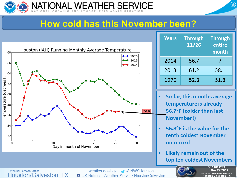
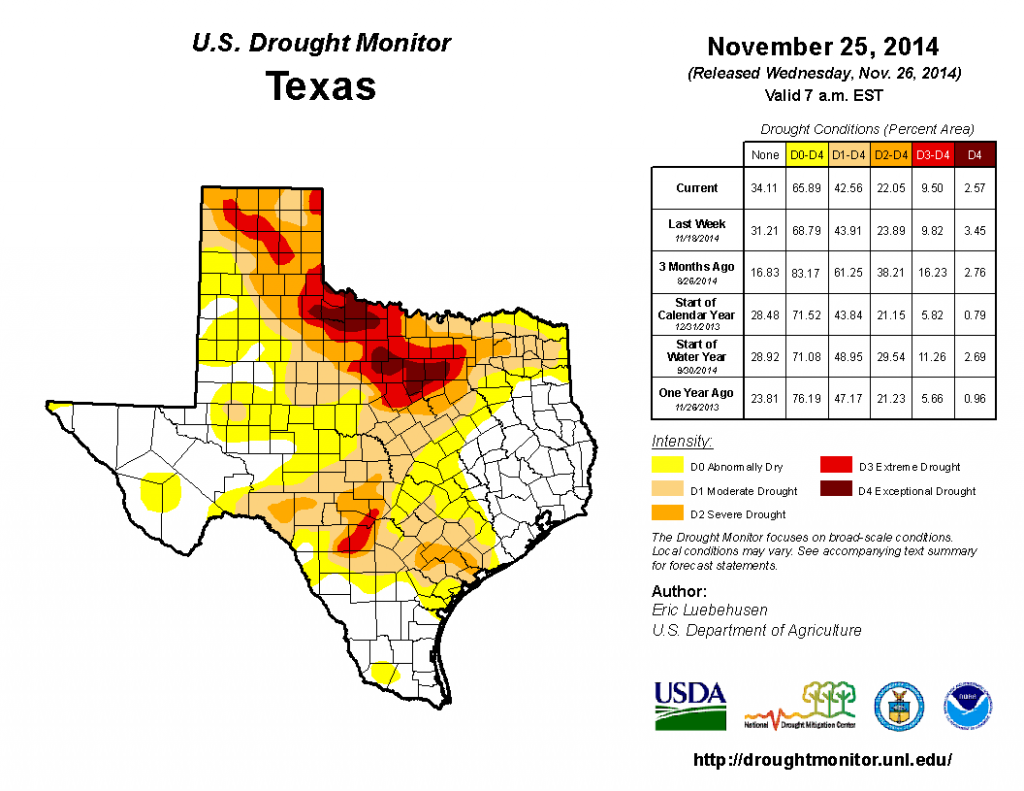
Another chilly morning across our Region with temperatures still running below normal for this time of year. The departures for the month of November will provide for a colder November than last year and end the month well below normal. This will mean that November 2014 will rank just above one of the coldest November on record (1976) and we have seen significant changes to the drought index where only N Texas is experiencing extreme drought conditions and slightly more than 34% of Texas is no longer in a drought category. That is a tremendous improvement in our multi year drought situation and Central Texas has seen a huge improvement which is very welcomed.
Posted: Fri Nov 28, 2014 8:49 am
by Ntxw
Hope everyone had a great Thanksgiving. The models have been trying to bottle up the cold air in the central plains, well now it looks like the EPO is going to drill it right on through come Sunday night and Monday at the low levels anyway to start December. Highs will struggle to warm mid 40s Monday.
Re: Texas Fall-2014
Posted: Fri Nov 28, 2014 1:32 pm
by orangeblood
The biggest question to me re: this winter is when/where is that winter Aleutian Low locking in. Most of the analogs have this low above normal with big implications downstream on where the North American ridge will set up shop. Bastardi just mentioned a new typhoon about to form in the southwest pacific will be the catalyst once it recurves, around December 10th time frame. This might get winter started for a prolonged period of time, something to watch
Posted: Fri Nov 28, 2014 7:30 pm
by BigB0882
Even though the next week to 10 days don't show anything exciting as far as cold or winter weather, it sure will be nice and comfortable! I will take low to mid 70s and sunny every day if we can't have any fun otherwise. I just hope we have a cold snap for Christmas, I do not like 70s on Christmas day!
I will be going on a cruise from Dec 18-22 so if I had to bet, a huge winter storm will hit all of TX and LA on those days since I will be gone. Just how my luck works.

Posted: Sat Nov 29, 2014 12:50 am
by Nairobi
ECMWF still showing no freezes for Austin or Dallas through December 8. Tuesday will have the coolest afternoon (high near 52 in Austin) with very quick warming thereafter.
GFS is similar but a bit warmer for Austin. No forecast freezes through December 14.
Where is this supposed typhoon supposed to be? Southwest Pacific is near Australia. The only currently forecast typhoon in the northwest Pacific is not supposed to recurve.
The drought relief has had almost zero benefit to the Highland Lakes.
Posted: Sat Nov 29, 2014 3:05 am
by somethingfunny
I have a tough time believing no freeze will occur at Dallas Tuesday morning, though cloud cover might keep the urban area just above.
Typhoons only occur in the Northwest Pacific, so.... the Southwest Pacific in the context of a typhoon would be the Philippine Sea and South China Sea, where we have Sinlaku and some more prognosticated for next week. We usually need strong recurve rather than low-riders to kink up the jet stream, though last year Haiyan was so powerful that it roughed up the global pattern even as a weakening extratropical thing curving up overland through central China and brought us a wave of powerful cold snaps culminating in an awful ice storm. Sinlaku is nowhere near powerful enough to have any real effect on our weather over here but let's see what comes down the WPAC pike next week and the week after.
This past week and this weekend has been classic "Chamber of Commerce weather", the sort of weather we love to show off to our families visiting from out of town.