Texas Fall 2013

U.S. & Caribbean Weather Discussions and Severe Weather Events

Moderator: S2k Moderators

Forum rules

The posts in this forum are NOT official forecast and should not be used as such. They are just the opinion of the poster and may or may not be backed by sound meteorological data. They are NOT endorsed by any professional institution or STORM2K.

Help Support Storm2K
Message
Author
orangeblood
S2K Supporter
S2K Supporter
Posts: 3334
Joined: Tue Dec 15, 2009 6:14 pm
Location: Fort Worth, TX

Re: Texas Fall 2013

#1421 Postby orangeblood » Wed Nov 27, 2013 4:15 pm

Todays 12Z European Model goes to the extreme option, bringing some 55 deg F below normal temps across parts of Colorado next Friday. Lower levels winds coming straight out of the Arctic all the way to the Texas Coast, pretty unbelievable model run.

Image

Lower Level wind/Temps

Image
0 likes   

User avatar
Rgv20
S2K Supporter
S2K Supporter
Posts: 2456
Age: 37
Joined: Wed Jan 05, 2011 5:42 pm
Location: Edinburg/McAllen Tx

#1422 Postby Rgv20 » Wed Nov 27, 2013 4:24 pm

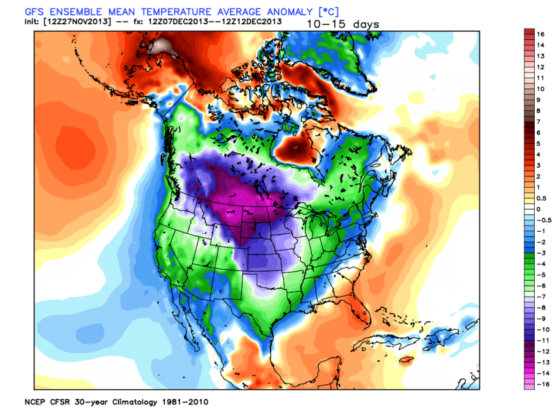
12zGFS Ensembles Means are pretty impressive with the negative temperature anomalies in the 10-15 day...Interesting days ahead for model watching!

Image
0 likes   
The following post is NOT an official forecast and should not be used as such. It is just the opinion of the poster and may or may not be backed by sound meteorological data. It is NOT endorsed by any professional institution including storm2k.org For Official Information please refer to the NHC and NWS products.

BigB0882
S2K Supporter
S2K Supporter
Posts: 2219
Joined: Thu Jul 03, 2003 12:08 am
Location: Baton Rouge, LA
Contact:

#1423 Postby BigB0882 » Wed Nov 27, 2013 5:12 pm

I'm going to need the models to shunt that Eastward just a little!! SELA is just missing out on the cold, it looks like.
0 likes   

User avatar
somethingfunny
ChatStaff
ChatStaff
Posts: 3926
Age: 35
Joined: Thu May 31, 2007 10:30 pm
Location: McKinney, Texas

Re: Texas Fall 2013

#1424 Postby somethingfunny » Wed Nov 27, 2013 7:08 pm

NWS Fort Worth wrote:A NEW ARCTIC HIGH HAS BEGUN TO DEVELOP ACROSS INTERIOR ALASKA AND
YUKON TERRITORY. IN THE MIDDAY DARKNESS...ARCTIC VILLAGE IN ALASKA
(PARC) IS CURRENTLY AT -35F. THIS FRIGID AIR WILL INTENSIFY AND
DEEPEN THE REMAINDER OF THE WEEK...EVENTUALLY SPILLING DOWN THE
HIGH TERRAIN EAST OF THE NORTHERN ROCKIES. THE LEADING FRONT WILL
CROSS SOUTH OF THE 49TH PARALLEL ON MONDAY AND CONTINUE BARRELING
SOUTH. THIS EARLY IN THE SEASON...THERE ARE TYPICALLY LONG
INTERLUDES BETWEEN ARCTIC INTRUSIONS. EVEN IF THESE THAWS ARE
BRIEF...THERE USUALLY IS NOT ENOUGH SNOWPACK TO PREVENT
CONSIDERABLE MODERATION OF THE SUBSEQUENT ARCTIC AIR MASS.
HOWEVER...THIS NEXT ARCTIC INTRUSION WILL ENCOUNTER THE MOST
EXPANSIVE SNOW COVER ACROSS THE LOWER 48 THIS EARLY IN THE SEASON
IN MORE THAN A DECADE. THE FRONT WOULD LIKELY ARRIVE IN NORTH
TEXAS NEAR THE END OF THE CURRENT 7-DAY FORECAST. POSTFRONTAL
TEMPERATURES WILL BE INTRODUCED WITH THE THURSDAY MORNING FORECAST
PACKAGE. AT THIS TIME...GUIDANCE IS RATHER UNIMPRESSED...BUT OUR
INCLINATION IS THAT THIS NEXT ARCTIC BLAST WILL BE STRONGER THAN
PROGGED.

25
0 likes   
I am not a meteorologist, and any posts made by me are not official forecasts or to be interpreted as being intelligent. These posts are just my opinions and are probably silly opinions.

Ntxw
Storm2k Moderator
Storm2k Moderator
Posts: 21565
Joined: Wed Oct 21, 2009 6:34 pm
Location: DFW, Texas

Re:

#1425 Postby Ntxw » Wed Nov 27, 2013 7:31 pm

BigB0882 wrote:I'm going to need the models to shunt that Eastward just a little!! SELA is just missing out on the cold, it looks like.


You won't miss the cold, it's just that the southeast is being fought back by the SE ridge thanks to -PNA. Cold will likely bleed from the plains but won't be as potent to the east as long as the ridge is there, if it is weaker the colder you will be.

What the models have changed to is instead of pushing the ridge back up to the north (arctic, retrogression) it is progressing it towards the NW coast. This makes much more sense given the pattern we have seen and the + Gulf of Alaska anomalies. That is a much colder scenario vs the prior.
0 likes   
The above post and any post by Ntxw is NOT an official forecast and should not be used as such. It is just the opinion of the poster and may or may not be backed by sound meteorological data. It is NOT endorsed by any professional institution including Storm2k. For official information, please refer to NWS products.

  Help support Storm2K!
Help Support Storm2K

Ntxw
Storm2k Moderator
Storm2k Moderator
Posts: 21565
Joined: Wed Oct 21, 2009 6:34 pm
Location: DFW, Texas

Re: Texas Fall 2013

#1426 Postby Ntxw » Wed Nov 27, 2013 7:41 pm

An important feature to watch. There is a flare of thunderstorms across the international dateline that will/is linking up to the westerlies. This is a feature to watch as it will be system #1 associated with the incoming Arctic front.

Image
0 likes   
The above post and any post by Ntxw is NOT an official forecast and should not be used as such. It is just the opinion of the poster and may or may not be backed by sound meteorological data. It is NOT endorsed by any professional institution including Storm2k. For official information, please refer to NWS products.


  Help support Storm2K!

Help Support Storm2K


User avatar
Rgv20
S2K Supporter
S2K Supporter
Posts: 2456
Age: 37
Joined: Wed Jan 05, 2011 5:42 pm
Location: Edinburg/McAllen Tx

#1427 Postby Rgv20 » Wed Nov 27, 2013 7:42 pm

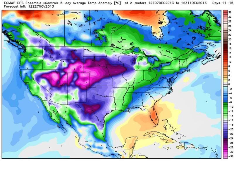
Joe Bastardi posted this graphic on twitter....12zECMWF Ensemble Control Run 11-15 Temperature Anomalies :eek: :cold:

Image
0 likes   
The following post is NOT an official forecast and should not be used as such. It is just the opinion of the poster and may or may not be backed by sound meteorological data. It is NOT endorsed by any professional institution including storm2k.org For Official Information please refer to the NHC and NWS products.

BigB0882
S2K Supporter
S2K Supporter
Posts: 2219
Joined: Thu Jul 03, 2003 12:08 am
Location: Baton Rouge, LA
Contact:

#1428 Postby BigB0882 » Wed Nov 27, 2013 7:49 pm

Can someone explain temperature anomalies? For example, that graph shows Baton Rouge around the -10 range. Does that means temperatures will be about 10 degrees below normal? So if our high is typically 65 then a high of about 55?

What were the temperature anomalies for this latest event? I would say that our highs were much more than 10 degrees below normal, more like 20 but I don't remember seeing these graphs before hand. I know often time the temps are a lot colder than progged so that map could be very telling if it is being conservative.
0 likes   

orangeblood
S2K Supporter
S2K Supporter
Posts: 3334
Joined: Tue Dec 15, 2009 6:14 pm
Location: Fort Worth, TX

Re: Texas Fall 2013

#1429 Postby orangeblood » Wed Nov 27, 2013 8:01 pm

:uarrow: :uarrow: :uarrow: That's about as cold a 5 stay stretch as you'll ever find on a model run. To give you an idea of what kind of precip is associated with this Euro Control Run, just to wet Portastorm's appetite

Image
Last edited by orangeblood on Wed Nov 27, 2013 9:07 pm, edited 1 time in total.
0 likes   

User avatar
Texas Snowman
Storm2k Moderator
Storm2k Moderator
Posts: 6085
Joined: Fri Jan 25, 2008 11:29 am
Location: Denison, Texas

Re: Texas Fall 2013

#1430 Postby Texas Snowman » Wed Nov 27, 2013 8:09 pm

orangeblood wrote::uarrow: :uarrow: :uarrow: That's about as cold a 5 stay stretch as you'll ever find on a model run. To give you an idea of what kind of precip is associated with this Euro Control Run, just for to wet Portastorm's appetite

http://models.weatherbell.com/ecmwf/201 ... nus_54.png


Wxman57 is going to love December! :D
0 likes   
The above post and any post by Texas Snowman is NOT an official forecast and should not be used as such. It is just the opinion of the poster and may or may not be backed by sound meteorological data. It is NOT endorsed by any professional institution including storm2k.org. For official information, please refer to NWS products.

Ntxw
Storm2k Moderator
Storm2k Moderator
Posts: 21565
Joined: Wed Oct 21, 2009 6:34 pm
Location: DFW, Texas

Re:

#1431 Postby Ntxw » Wed Nov 27, 2013 8:10 pm

BigB0882 wrote:Can someone explain temperature anomalies? For example, that graph shows Baton Rouge around the -10 range. Does that means temperatures will be about 10 degrees below normal? So if our high is typically 65 then a high of about 55?

What were the temperature anomalies for this latest event? I would say that our highs were much more than 10 degrees below normal, more like 20 but I don't remember seeing these graphs before hand. I know often time the temps are a lot colder than progged so that map could be very telling if it is being conservative.


Baton Rouge's most recent cold snap was between -12 to -14 over 3/4 days averaging about -13. If you look at the maps it's about the same span on the charts.
0 likes   
The above post and any post by Ntxw is NOT an official forecast and should not be used as such. It is just the opinion of the poster and may or may not be backed by sound meteorological data. It is NOT endorsed by any professional institution including Storm2k. For official information, please refer to NWS products.


  Help support Storm2K!

Help Support Storm2K


User avatar
TeamPlayersBlue
Category 5
Category 5
Posts: 3310
Joined: Tue Feb 02, 2010 1:44 am
Location: Denver/Applewood, CO

#1432 Postby TeamPlayersBlue » Wed Nov 27, 2013 8:35 pm

Those maps are in CELCIUS though
0 likes   
Personal Forecast Disclaimer:
The posts in this forum are NOT official forecast and should not be used as such. They are just the opinion of the poster and may or may not be backed by sound meteorological data. They are NOT endorsed by any professional institution or storm2k.org. For official information, please refer to the NHC and NWS products.

BigB0882
S2K Supporter
S2K Supporter
Posts: 2219
Joined: Thu Jul 03, 2003 12:08 am
Location: Baton Rouge, LA
Contact:

Re:

#1433 Postby BigB0882 » Wed Nov 27, 2013 9:15 pm

TeamPlayersBlue wrote:Those maps are in CELCIUS though


Oh, the anomalies are in Celsius? That makes a huge difference. So -10 would be equal to about 18 F difference. No wonder people see this as being so cold. And again, aren't the models often conservative on the cold temps?
0 likes   

Ntxw
Storm2k Moderator
Storm2k Moderator
Posts: 21565
Joined: Wed Oct 21, 2009 6:34 pm
Location: DFW, Texas

#1434 Postby Ntxw » Wed Nov 27, 2013 9:27 pm

Folks the latest EPO continues to plunge to almost -2SD's. All guidance including ensembles are remarkably similar heading it into 4-5SD's below. The Pacific Ocean is going hog-wild and will be dealing us the big hand.
Last edited by Ntxw on Wed Nov 27, 2013 9:28 pm, edited 1 time in total.
0 likes   
The above post and any post by Ntxw is NOT an official forecast and should not be used as such. It is just the opinion of the poster and may or may not be backed by sound meteorological data. It is NOT endorsed by any professional institution including Storm2k. For official information, please refer to NWS products.


  Help support Storm2K!

Help Support Storm2K


orangeblood
S2K Supporter
S2K Supporter
Posts: 3334
Joined: Tue Dec 15, 2009 6:14 pm
Location: Fort Worth, TX

Re:

#1435 Postby orangeblood » Wed Nov 27, 2013 9:27 pm

TeamPlayersBlue wrote:Those maps are in CELCIUS though


Yes, so some of those purples are 50 plus degrees F below normal :double:
0 likes   

BigB0882
S2K Supporter
S2K Supporter
Posts: 2219
Joined: Thu Jul 03, 2003 12:08 am
Location: Baton Rouge, LA
Contact:

#1436 Postby BigB0882 » Wed Nov 27, 2013 9:38 pm

Now I just need the models to begin moving that cold East a little in future runs. I want the COLD. We have had no winter for too many years in a row. I will settle for a record cold Fall!

What is crazy is the snow cover will be great so if this sets up again then the next cold batch could be even more potent.

Of course, if this even happens. I have been fooled too many times over the last few winters. lol
0 likes   

User avatar
Portastorm
Storm2k Moderator
Storm2k Moderator
Posts: 9787
Age: 62
Joined: Fri Jul 11, 2003 9:16 am
Location: South Austin, TX
Contact:

Re:

#1437 Postby Portastorm » Wed Nov 27, 2013 10:28 pm

Ntxw wrote:Folks the latest EPO continues to plunge to almost -2SD's. All guidance including ensembles are remarkably similar heading it into 4-5SD's below. The Pacific Ocean is going hog-wild and will be dealing us the big hand.


Indeed. That is what will drive this pattern in the next 30 days. The Pacific rules the roost as you, Ntxw, and orangeblood have been wisely pointing out to us for weeks. Here's hoping for several wintry weather episodes before the pattern relaxes probably in early January.

Man, I do love those Euro ensembles which orangeblood posted a few posts back. They've got me rummaging through my closet for the kicking shoes! :wink:
0 likes   
Any forecasts under my name are to be taken with a grain of salt. Get your best forecasts from the National Weather Service and National Hurricane Center.

I'm a certified Advanced SKYWARN-trained spotter and am active on Twitter at @TravisCOSW, a social media partner of the NWS Austin-San Antonio office.

Ntxw
Storm2k Moderator
Storm2k Moderator
Posts: 21565
Joined: Wed Oct 21, 2009 6:34 pm
Location: DFW, Texas

Re: Re:

#1438 Postby Ntxw » Wed Nov 27, 2013 10:47 pm

Portastorm wrote:Indeed. That is what will drive this pattern in the next 30 days. The Pacific rules the roost as you, Ntxw, and orangeblood have been wisely pointing out to us for weeks. Here's hoping for several wintry weather episodes before the pattern relaxes probably in early January.

Man, I do love those Euro ensembles which orangeblood posted a few posts back. They've got me rummaging through my closet for the kicking shoes! :wink:


Definitely, last year and this year has turned my understanding of indices a complete 180! It's striking that 2012/13 featured a predominant -AO yet because of the +EPO we were flushed with the PAC jet and a semi Alaskan vortex. This year a predominant +AO yet a great Pacific was able to mask it, everyone else was warm but not us in NA. Don't even get me started with 2011/12...

I think we need a better understanding of the EPO and how there are different variations such as in a previous post about retrograding -EPO and progressing one. There are big differences!
0 likes   
The above post and any post by Ntxw is NOT an official forecast and should not be used as such. It is just the opinion of the poster and may or may not be backed by sound meteorological data. It is NOT endorsed by any professional institution including Storm2k. For official information, please refer to NWS products.


  Help support Storm2K!

Help Support Storm2K


Snowman67
Category 2
Category 2
Posts: 604
Joined: Thu Dec 31, 2009 12:44 pm
Location: Tomball, TX

#1439 Postby Snowman67 » Thu Nov 28, 2013 12:32 am

The forecast discussion of the Bismark, ND NWS office gives some insight as to the origin of the upcoming cold air intrusion into the U.S.

"ONE THING THAT IS MORE CERTAIN IS THE INTRUSION OF COLD AIR. A
VERY COLD AIRMASS IS SETTING UP ACROSS EASTERN SIBERIA AND IS
PROGGED TO ENTER EASTERN ALASKA AND FROM THERE MAKE A BEELINE
TOWARD THE CENTRAL CONTINENTAL USA. THIS COULD POTENTIALLY BE THE
COLDEST AIR WE HAVE SEEN YET WITH 850MB TEMPS AROUND -25."
0 likes   
Any forecast I make is based on my opinion only. Please refer to the NWS or NHC for official forecasts.

User avatar
Portastorm
Storm2k Moderator
Storm2k Moderator
Posts: 9787
Age: 62
Joined: Fri Jul 11, 2003 9:16 am
Location: South Austin, TX
Contact:

Re: Texas Fall 2013

#1440 Postby Portastorm » Thu Nov 28, 2013 7:33 am

At 6 am Central time on Thanksgiving morning, here's an impressive map. Surface temps. Looks like at least 80% of the CONUS is at or below freezing. As I write this, it's 31 degrees at the Portastorm Weather Center.

Image

Uploaded with ImageShack.us
0 likes   
Any forecasts under my name are to be taken with a grain of salt. Get your best forecasts from the National Weather Service and National Hurricane Center.

I'm a certified Advanced SKYWARN-trained spotter and am active on Twitter at @TravisCOSW, a social media partner of the NWS Austin-San Antonio office.


Return to “USA & Caribbean Weather”

Who is online

Users browsing this forum: No registered users and 54 guests