Texas Fall-2015

U.S. & Caribbean Weather Discussions and Severe Weather Events

Moderator: S2k Moderators

Forum rules

The posts in this forum are NOT official forecast and should not be used as such. They are just the opinion of the poster and may or may not be backed by sound meteorological data. They are NOT endorsed by any professional institution or STORM2K.

Help Support Storm2K
Message
Author
User avatar
Portastorm
Storm2k Moderator
Storm2k Moderator
Posts: 9914
Age: 63
Joined: Fri Jul 11, 2003 9:16 am
Location: Round Rock, TX
Contact:

Re:

#141 Postby Portastorm » Wed Sep 09, 2015 9:17 am

weatherdude1108 wrote:6:30am - Watching the complex of rain enter the Colorado River basin north of Buchanan. Good spot to be!
:wink:
I am hoping it makes its way further down here to replenish my rain barrel and help my soil cracks and plants. Today is my watering day, but I didn't turn on the sprinklers, in excited anticipation of this event. I just hope I'm not wrong in turning off sprinklers this time (based on the historical infamous Austin bubble dome).


The "bubble dome" appears to be working in earnest this morning. :cry:
0 likes   
Any forecasts under my name are to be taken with a grain of salt. Get your best forecasts from the National Weather Service and National Hurricane Center.

aggiecutter
Category 5
Category 5
Posts: 1753
Joined: Thu Oct 14, 2004 9:22 pm
Location: Texarkana

Re: Texas Fall-2015

#142 Postby aggiecutter » Wed Sep 09, 2015 10:21 am

NWS forecast for Texarkana this weekend:

Saturday Mostly sunny, with a high near 79.
Saturday Night Mostly clear, with a low around 55.
Sunday Sunny, with a high near 79.
Sunday Night Mostly clear, with a low around 57.
0 likes   

weatherdude1108
Category 5
Category 5
Posts: 4228
Joined: Tue Dec 13, 2011 1:04 pm
Location: Northwest Austin/Cedar Park, TX

Re: Re:

#143 Postby weatherdude1108 » Wed Sep 09, 2015 10:23 am

Portastorm wrote:
weatherdude1108 wrote:6:30am - Watching the complex of rain enter the Colorado River basin north of Buchanan. Good spot to be!
:wink:
I am hoping it makes its way further down here to replenish my rain barrel and help my soil cracks and plants. Today is my watering day, but I didn't turn on the sprinklers, in excited anticipation of this event. I just hope I'm not wrong in turning off sprinklers this time (based on the historical infamous Austin bubble dome).


The "bubble dome" appears to be working in earnest this morning. :cry:


I really don't understand. :(
0 likes   

texas1836
Tropical Storm
Tropical Storm
Posts: 223
Age: 55
Joined: Fri Aug 17, 2012 10:10 am
Location: Ruidoso, New Mexico

#144 Postby texas1836 » Wed Sep 09, 2015 10:41 am

What we need for an early cool down is another Bering Sea Super Storm, like we had last November. Maybe even 4, in a row, slowly churning across Canada and the US.
0 likes   

User avatar
TheProfessor
Professional-Met
Professional-Met
Posts: 3506
Age: 28
Joined: Tue Dec 03, 2013 10:56 am
Location: Wichita, Kansas

#145 Postby TheProfessor » Wed Sep 09, 2015 11:01 am

They test the tornado sirens every week here on campus at OSU, even when rain is in the forecast. I'm still getting used to it lol.
0 likes   
An alumnus of The Ohio State University.

Your local National Weather Service office is your best source for weather information.

Ralph's Weather
S2K Supporter
S2K Supporter
Posts: 3269
Age: 38
Joined: Fri Dec 13, 2013 11:55 am
Location: Lindale, TX
Contact:

Re: Texas Fall-2015

#146 Postby Ralph's Weather » Wed Sep 09, 2015 11:43 am

aggiecutter wrote:NWS forecast for Texarkana this weekend:

Saturday Mostly sunny, with a high near 79.
Saturday Night Mostly clear, with a low around 55.
Sunday Sunny, with a high near 79.
Sunday Night Mostly clear, with a low around 57.


It sure is refreshing to see. I am hoping for sub 55 here Sunday morning.
0 likes   
Follow on Facebook at Ralph's Weather.

Brent
S2K Supporter
S2K Supporter
Posts: 38087
Age: 36
Joined: Sun May 16, 2004 10:30 pm
Location: Tulsa Oklahoma
Contact:

Re: Texas Fall-2015

#147 Postby Brent » Wed Sep 09, 2015 12:19 pm

On the edge of the metroplex! :ggreen:

Saturday
Mostly sunny, with a high near 81. North northeast wind around 10 mph.
Saturday Night
Mostly clear, with a low around 59. North northeast wind 5 to 10 mph.

Sunday
Mostly sunny, with a high near 82. East northeast wind around 5 mph becoming southeast in the afternoon.

Around 0.70" this morning... but then I see KDAL had over 2.5" :roll: :P
0 likes   
#neversummer

User avatar
wxman57
Moderator-Pro Met
Moderator-Pro Met
Posts: 22976
Age: 67
Joined: Sat Jun 21, 2003 8:06 pm
Location: Houston, TX (southwest)

Re: Texas Fall-2015

#148 Postby wxman57 » Wed Sep 09, 2015 1:04 pm

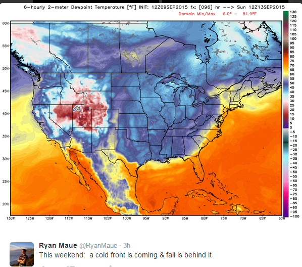
12Z GFS is a few degrees warmer for Houston with this weekend's frontal passage. Rainy next week across Houston.

Image
0 likes   

aggiecutter
Category 5
Category 5
Posts: 1753
Joined: Thu Oct 14, 2004 9:22 pm
Location: Texarkana

Re: Texas Fall-2015

#149 Postby aggiecutter » Wed Sep 09, 2015 4:22 pm

Image
0 likes   

fendie
S2K Supporter
S2K Supporter
Posts: 151
Joined: Sun Aug 26, 2012 10:33 am
Location: Austin, TX

#150 Postby fendie » Wed Sep 09, 2015 6:13 pm

Nice afternoon area forecast discussion out of the Houston/Galveston NWS office...


Area forecast discussion
National Weather Service Houston/Galveston Texas
339 PM CDT Wednesday Sep 9 2015

...

Extended forecast...
amplified pattern briefly becomes more zonal Sunday into Monday
with another strong trough over the north rockies developing on
Tuesday. After cool days on Sunday and Monday...moisture return
will occur in earnest as cyclogenesis occurs late Monday into
Tuesday drawing up significant moisture from the Bay of Campeche.
This will increase thunderstorm chances Tuesday into Wednesday as
precipitation water values increase above 2 inches during this time.

The 12z European model (ecmwf) is back trending towards some type of tropical
cyclone development Monday into Tuesday where the GFS has a weak
surface low if anything. This system then tracks northward into
the northwest Gulf by the middle of next week rather slowly. The GFS
shows quite a bit more SW shear over the northwest Gulf during this time
where the European model (ecmwf) has weaker west-southwest shear. The European model (ecmwf) has been changing
its timing of when development occurs be it on day 5 one run or
day 6-7 on the next. The trends with the European model (ecmwf) have been
inconsistent from run to run but have a tropical signal
nonetheless that warrants at least monitoring. At this point all
we can really say is that there are a lot of question Marks for
the day 6/7 forecast. We have to remember that this is just one
deterministic model run with little ensemble support. It does look
like a good chance for thunderstorms with locally heavy rainfall
Tuesday into Wednesday. Highest rainfall totals will be along the
coast. Strong winds with the system over the Gulf will elevate
tide levels and surf along the coast. Outside of this it is too
early in the forecast process to discuss any details in the
forecast or impacts.

39

&&
0 likes   

User avatar
Rgv20
S2K Supporter
S2K Supporter
Posts: 2466
Age: 38
Joined: Wed Jan 05, 2011 5:42 pm
Location: Edinburg/McAllen Tx

#151 Postby Rgv20 » Wed Sep 09, 2015 7:23 pm

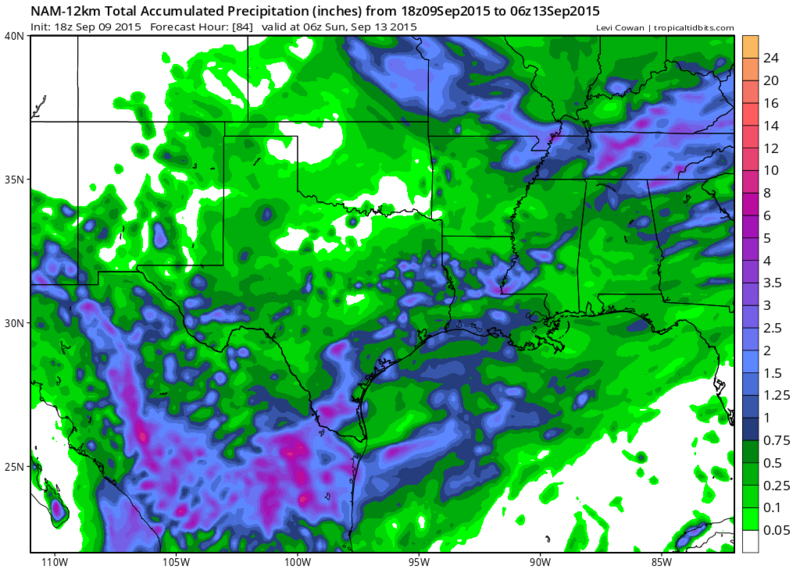
18zNAM showing some healthy rain totals of 2+ inches for a wide area of South Texas thru Saturday night! :P Come on Rain!

Image
0 likes   
The following post is NOT an official forecast and should not be used as such. It is just the opinion of the poster and may or may not be backed by sound meteorological data. It is NOT endorsed by any professional institution including storm2k.org For Official Information please refer to the NHC and NWS products.

weatherdude1108
Category 5
Category 5
Posts: 4228
Joined: Tue Dec 13, 2011 1:04 pm
Location: Northwest Austin/Cedar Park, TX

Re:

#152 Postby weatherdude1108 » Wed Sep 09, 2015 7:25 pm

Rgv20 wrote:18zNAM showing some healthy rain totals of 2+ inches for a wide area of South Texas thru Saturday night! :P Come on Rain!

Image


Notice the small donut hole over Austin.lol
0 likes   
The preceding post is NOT an official forecast, and should not be used as such. It is only the opinion of the poster and may or may not be backed by sound meteorological data. It is NOT endorsed by any professional institution including storm2k.org. For Official Information please refer to the NHC and NWS products.

User avatar
Rgv20
S2K Supporter
S2K Supporter
Posts: 2466
Age: 38
Joined: Wed Jan 05, 2011 5:42 pm
Location: Edinburg/McAllen Tx

#153 Postby Rgv20 » Wed Sep 09, 2015 7:28 pm

:uarrow: Porta's Rain Shield is Strong!! lol
0 likes   
The following post is NOT an official forecast and should not be used as such. It is just the opinion of the poster and may or may not be backed by sound meteorological data. It is NOT endorsed by any professional institution including storm2k.org For Official Information please refer to the NHC and NWS products.

User avatar
Tireman4
S2K Supporter
S2K Supporter
Posts: 5853
Age: 59
Joined: Fri Jun 30, 2006 1:08 pm
Location: Humble, Texas
Contact:

#154 Postby Tireman4 » Wed Sep 09, 2015 7:33 pm

Porta will win...the Indians will the playoffs..the Browns will have a quarterback..
0 likes   

User avatar
JDawg512
Category 5
Category 5
Posts: 1075
Age: 45
Joined: Mon Aug 26, 2013 8:56 pm
Location: Austin
Contact:

Re: Texas Fall-2015

#155 Postby JDawg512 » Wed Sep 09, 2015 8:24 pm

There's definitely no donut hole over Austin tonight as a cluster of thunderstorms is developing right over the city. Movement is slow. I got several excellent pictures of the storm forming over my house and to the north and west. Will need to monitor closely because these are dumping a good amount of rain over the same areas.
0 likes   
Resident Rain Miser

I am a weather hobbyist living 3.5 miles south of Downtown Austin and in no way or fashion should anything I say concerning forecasts be taken seriously. Please check your local NWS for accurate weather forecasting and conditions.

weatherdude1108
Category 5
Category 5
Posts: 4228
Joined: Tue Dec 13, 2011 1:04 pm
Location: Northwest Austin/Cedar Park, TX

Re: Texas Fall-2015

#156 Postby weatherdude1108 » Wed Sep 09, 2015 9:24 pm

JDawg512 wrote:There's definitely no donut hole over Austin tonight as a cluster of thunderstorms is developing right over the city. Movement is slow. I got several excellent pictures of the storm forming over my house and to the north and west. Will need to monitor closely because these are dumping a good amount of rain over the same areas.


We drove through a massive downpour tonight on way back to house. As soon as I got to my house and surrounding area, the streets were barely damp, and even DRY under the trees. :roll: Sprinkling now.

I should have watered today.
0 likes   

Shoshana
Category 5
Category 5
Posts: 1414
Joined: Thu Sep 09, 2004 7:50 pm
Location: NE Austin

Re: Texas Fall-2015

#157 Postby Shoshana » Wed Sep 09, 2015 10:21 pm

So far what I can see from the patio, we've had 2+" so far this evening. And it's still raining pretty hard. At least we still have electricity - a bunch of people (3200+) near Howard are dark.
0 likes   

weatherdude1108
Category 5
Category 5
Posts: 4228
Joined: Tue Dec 13, 2011 1:04 pm
Location: Northwest Austin/Cedar Park, TX

#158 Postby weatherdude1108 » Wed Sep 09, 2015 10:51 pm

It rained steadily for about 10 minutes. Not even a third of an inch. I turned my sprinkler system on before bed to run through one cycle to supplement my third of an inch before my watering day is officially over for a week, and hopefully not needed for months (Niño). But glad for my fellow Austinites who benefitted tonight from parked storms. :wink:
0 likes   

User avatar
TheProfessor
Professional-Met
Professional-Met
Posts: 3506
Age: 28
Joined: Tue Dec 03, 2013 10:56 am
Location: Wichita, Kansas

#159 Postby TheProfessor » Thu Sep 10, 2015 10:02 am

There's this little bit of soap on the wall in the shower and it's super annoying because I don't want to touch so I tried to wash it away but everything time I tried the water would just go right around it, I tried to hit it with different angles and it was like the water hit a shield just before It got to the soap. I named the soap spot Austin. :lol:
0 likes   
An alumnus of The Ohio State University.

Your local National Weather Service office is your best source for weather information.

User avatar
Portastorm
Storm2k Moderator
Storm2k Moderator
Posts: 9914
Age: 63
Joined: Fri Jul 11, 2003 9:16 am
Location: Round Rock, TX
Contact:

Re:

#160 Postby Portastorm » Thu Sep 10, 2015 10:44 am

TheProfessor wrote:There's this little bit of soap on the wall in the shower and it's super annoying because I don't want to touch so I tried to wash it away but everything time I tried the water would just go right around it, I tried to hit it with different angles and it was like the water hit a shield just before It got to the soap. I named the soap spot Austin. :lol:


Oh, aren't you funny?! Don't you have some studying to do youngster? :lol:

For the record, the Portastorm Weather Center reported .24" of rainfall last evening. So there!
0 likes   
Any forecasts under my name are to be taken with a grain of salt. Get your best forecasts from the National Weather Service and National Hurricane Center.


Return to “USA & Caribbean Weather”

Who is online

Users browsing this forum: No registered users and 11 guests