Texas Fall 2012

U.S. & Caribbean Weather Discussions and Severe Weather Events

Moderator: S2k Moderators

Forum rules

The posts in this forum are NOT official forecast and should not be used as such. They are just the opinion of the poster and may or may not be backed by sound meteorological data. They are NOT endorsed by any professional institution or STORM2K.

Help Support Storm2K
Message
Author
User avatar
Rgv20
S2K Supporter
S2K Supporter
Posts: 2466
Age: 38
Joined: Wed Jan 05, 2011 5:42 pm
Location: Edinburg/McAllen Tx

Re:

#141 Postby Rgv20 » Fri Oct 19, 2012 10:40 pm

Ntxw wrote:Should watch the EPAC closely, GFS has been trying to throw Rosa-to-be into the mix of fun and games late month.


12&18zGFS is eye candy right now :lol:


12zGFS on October 30th has a 997mb low near Laredo which looks to be the remnant energy of Rosa to be..
Image

18zGFS on Halloween day has a 993mb low just East of Brownsville which also looks to be energy from Rosa to be..
Image
0 likes   
The following post is NOT an official forecast and should not be used as such. It is just the opinion of the poster and may or may not be backed by sound meteorological data. It is NOT endorsed by any professional institution including storm2k.org For Official Information please refer to the NHC and NWS products.

User avatar
Ntxw
Storm2k Moderator
Storm2k Moderator
Posts: 22784
Joined: Wed Oct 21, 2009 6:34 pm
Location: DFW, Texas

#142 Postby Ntxw » Fri Oct 19, 2012 11:41 pm

0z GFS follows in line with the ideas. The kind of blocking that's been shown for many many runs is absolutely ridiculous. It's going to create (if verified) such a large dome of cold air over North America and stick it there. It won't be transient even if we get half of the blocking down. The upcoming pattern is better than anything we have seen ALL of last year let alone for Oct/Nov.

http://mag.ncep.noaa.gov/NCOMAGWEB/appc ... mageSize=M

If we look at current 500mb charts, changes are taking place over Alaska and western Canada. High pressure is building and cold pool emerging over British Columbia and the Yukon. The storm currently over the lakes will begin to pump up the ridge into Greenland (-NAO).

Image
0 likes   
The above post and any post by Ntxw is NOT an official forecast and should not be used as such. It is just the opinion of the poster and may or may not be backed by sound meteorological data. It is NOT endorsed by any professional institution including Storm2k. For official information, please refer to NWS products.

  Help support Storm2K!
Help Support Storm2K

User avatar
Portastorm
Storm2k Moderator
Storm2k Moderator
Posts: 9914
Age: 63
Joined: Fri Jul 11, 2003 9:16 am
Location: Round Rock, TX
Contact:

Re: Texas Fall 2012

#143 Postby Portastorm » Sat Oct 20, 2012 10:54 am

While it is a harsh term, especially for our family friendly Storm 2K forum, this is what is called model stuff. :wink:

I'd rather we saw this kind of set up in December ... but I guess beggars can't be choosers.
0 likes   
Any forecasts under my name are to be taken with a grain of salt. Get your best forecasts from the National Weather Service and National Hurricane Center.

User avatar
Ntxw
Storm2k Moderator
Storm2k Moderator
Posts: 22784
Joined: Wed Oct 21, 2009 6:34 pm
Location: DFW, Texas

#144 Postby Ntxw » Sat Oct 20, 2012 12:45 pm

12z GFS is even more robust, sending the 850 0c line into central Texas.

Source region, below 0 temps are coming in with the building high over Alaska.

Image
0 likes   
The above post and any post by Ntxw is NOT an official forecast and should not be used as such. It is just the opinion of the poster and may or may not be backed by sound meteorological data. It is NOT endorsed by any professional institution including Storm2k. For official information, please refer to NWS products.


  Help support Storm2K!

Help Support Storm2K


User avatar
Tireman4
S2K Supporter
S2K Supporter
Posts: 5853
Age: 59
Joined: Fri Jun 30, 2006 1:08 pm
Location: Humble, Texas
Contact:

#145 Postby Tireman4 » Sat Oct 20, 2012 12:59 pm

Please come down Mr Front. Bring your goodness of cold with you. This upcoming week will be just lovely. Not. I have a race, which I am debating about running it ( due to injuries), October 27 at 7 am. Here is a question. I do wonder will be in the process of coming through at that time or after? Humm...
0 likes   

User avatar
iorange55
Category 5
Category 5
Posts: 2388
Joined: Thu Nov 13, 2008 9:47 pm
Location: Big D

Re: Texas Fall 2012

#146 Postby iorange55 » Sat Oct 20, 2012 1:49 pm

Wow, you're right, Ntxw. The 12z GFS looks like a model run you might see in December or January; not late October.
0 likes   

User avatar
Ntxw
Storm2k Moderator
Storm2k Moderator
Posts: 22784
Joined: Wed Oct 21, 2009 6:34 pm
Location: DFW, Texas

#147 Postby Ntxw » Sat Oct 20, 2012 4:12 pm

CPC just flipped their tune 180 and went colder.

Image
Image
0 likes   
The above post and any post by Ntxw is NOT an official forecast and should not be used as such. It is just the opinion of the poster and may or may not be backed by sound meteorological data. It is NOT endorsed by any professional institution including Storm2k. For official information, please refer to NWS products.


  Help support Storm2K!

Help Support Storm2K


User avatar
Portastorm
Storm2k Moderator
Storm2k Moderator
Posts: 9914
Age: 63
Joined: Fri Jul 11, 2003 9:16 am
Location: Round Rock, TX
Contact:

Re: Texas Fall 2012

#148 Postby Portastorm » Sat Oct 20, 2012 4:29 pm

Hmm ... Wxman57 better take stock of his cold-weather riding gear. :wink: :lol:
0 likes   
Any forecasts under my name are to be taken with a grain of salt. Get your best forecasts from the National Weather Service and National Hurricane Center.

User avatar
Rgv20
S2K Supporter
S2K Supporter
Posts: 2466
Age: 38
Joined: Wed Jan 05, 2011 5:42 pm
Location: Edinburg/McAllen Tx

#149 Postby Rgv20 » Sat Oct 20, 2012 7:13 pm

If the GFS were to verify it looks like the whole state of Texas will be in for a cool weekend! GFS Ensembles Mean has below normal temperatures in the range of 12-18 degrees Fahrenheit. :D ECMWF has the front a bit later and not as strong as the GFS tho..

12zGFS Ensembles Temperature Anomalies for Saturday
Image


12zGFS Ensembles Temperature Anomalies for Sunday
Image
0 likes   
The following post is NOT an official forecast and should not be used as such. It is just the opinion of the poster and may or may not be backed by sound meteorological data. It is NOT endorsed by any professional institution including storm2k.org For Official Information please refer to the NHC and NWS products.

weatherdude1108
Category 5
Category 5
Posts: 4228
Joined: Tue Dec 13, 2011 1:04 pm
Location: Northwest Austin/Cedar Park, TX

#150 Postby weatherdude1108 » Sun Oct 21, 2012 7:32 am

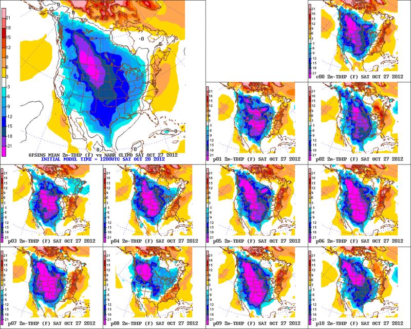
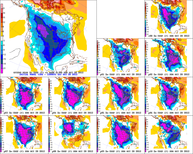
One of the models had a possible freeze next weekend for central Texas.
:eek: :cold:

.PREV DISCUSSION... /ISSUED 405 AM CDT SUN OCT 21 2012/

DISCUSSION...
HUMID AND ABOVE NORMAL TEMPERATURES WILL CONTINUE FOR A FEW MORE
DAYS BEFORE A MUCH COOLER PATTERN SETTLES OVER SOUTH CENTRAL TX LATE
FRIDAY INTO THE WEEKEND.

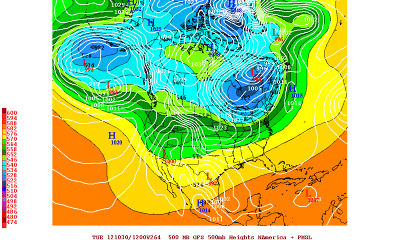
A PROGRESSIVE ZONAL PATTERN ALOFT WITH AN UPSTREAM DISTURBANCE
PASSING NORTH OF SOUTH CENTRAL TEXAS OVER THE NEXT COUPLE DAYS
WILL REINFORCE DEEP LOW LEVEL MOISTURE AND STABLE AIR ALOFT. THE
BREEZY SOUTH LOW LEVEL WINDS FEEDING INTO THIS PATTERN ALOFT WILL
PROMOTE A FEW MORNING SHOWERS...BUT NO SIGNIFICANT RAINFALL
AMOUNTS ARE EXPECTED. DAYTIME GUSTY WINDS WILL BE STRONGEST
TODAY...THEN TAPERING OFF SOME AS THE DISTURBANCE PASSES TO THE
NORTH MONDAY. RAIN CHANCES FROM THE DISTURBANCE CONTINUE TO BE
SHOWN MAINLY NORTH OF THE AREA...BUT A FEW THUNDERSTORMS COULD
FORM BRIEFLY OVER THE HILL COUNTRY BEFORE LIFTING NE.

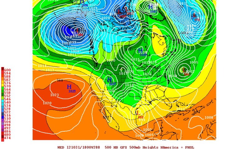
MEDIUM RANGE MODELS ARE GAINING MOMENTUM ON FORECASTING A SIGNIFICANT
FRONT AND MUCH COOLER AIR FOR THIS WEEKEND. THE GFS AND ECMWF ARE
CONVERGING TOWARD A DELAYED SOLUTION WITH THE STRENGTH AND TIMING
OF THE GFS FRONT LOOKING MORE REASONABLE FOR THIS FORECAST CYCLE.
THE DGEX WENT FROM A MODERATE PATTERN YESTERDAY TO A STRONG FRONT
AND POSSIBLE FREEZE FOR THIS WEEKEND
..
.SO THE SLIGHTLY LESS COOL
TEMPERATURES OF THE GFS IS PREFERRED OVER THE MILDER ECMWF. A
BRIEF PERIOD OF LIGHT OVERUNNING COULD GENERATE LIGHT SHOWERS
LATE FRIDAY...BUT THE DRY AIR PUSH FROM THE NORTH SHOULD LOWER
RAIN CHANCES ONCE THE FRONTAL INVERSION IS SUFFICIENTLY DEEP. POPS
COVER A BROADER RANGE OF TIME FROM EARLY FRIDAY TO EARLY SATURDAY
TO ACCOUNT FOR TIMING UNCERTAINTIES.
0 likes   
The preceding post is NOT an official forecast, and should not be used as such. It is only the opinion of the poster and may or may not be backed by sound meteorological data. It is NOT endorsed by any professional institution including storm2k.org. For Official Information please refer to the NHC and NWS products.

User avatar
Ntxw
Storm2k Moderator
Storm2k Moderator
Posts: 22784
Joined: Wed Oct 21, 2009 6:34 pm
Location: DFW, Texas

#151 Postby Ntxw » Sun Oct 21, 2012 1:29 pm

So we're all wondering what the models say today? Well certainly the typical battles we see! The cold front is now a when though, blue norther coming this next weekend towards Halloween. Widespread frost and freezes likely for North, Central, and the typical cold spots in SE Texas. We'll have to watch the front moving sooner timing since this air mass is very dense and deep. It might even try to snow in the high plains of the panhandle and west Texas since a lot of lagging vorticity will remain at the base of the trough.

GFS went from very cold to cold
Euro and Canadian have flopped from slightly cold to very cold.

Image
0 likes   
The above post and any post by Ntxw is NOT an official forecast and should not be used as such. It is just the opinion of the poster and may or may not be backed by sound meteorological data. It is NOT endorsed by any professional institution including Storm2k. For official information, please refer to NWS products.


  Help support Storm2K!

Help Support Storm2K


User avatar
vbhoutex
Storm2k Executive
Storm2k Executive
Posts: 29112
Age: 73
Joined: Wed Oct 09, 2002 11:31 pm
Location: Cypress, TX
Contact:

Re:

#152 Postby vbhoutex » Sun Oct 21, 2012 1:58 pm

Rgv20 wrote:If the GFS were to verify it looks like the whole state of Texas will be in for a cool weekend! GFS Ensembles Mean has below normal temperatures in the range of 12-18 degrees Fahrenheit. :D ECMWF has the front a bit later and not as strong as the GFS tho..

12zGFS Ensembles Temperature Anomalies for Saturday
http://i61.photobucket.com/albums/h62/c ... -13/D7.gif


12zGFS Ensembles Temperature Anomalies for Sunday
http://i61.photobucket.com/albums/h62/c ... -13/D8.gif

If I am reading those maps right it appears to me that we could have some 30's in the Northern Houston metro area with low to mid 40's all over the region. :cold: :froze:
0 likes   
Skywarn, C.E.R.T.
Please click below to donate to STORM2K to help with the expenses of keeping the site going:
Image

User avatar
Ntxw
Storm2k Moderator
Storm2k Moderator
Posts: 22784
Joined: Wed Oct 21, 2009 6:34 pm
Location: DFW, Texas

#153 Postby Ntxw » Sun Oct 21, 2012 5:25 pm

FW discussions this afternoon on the warm week and changes at the end of the period


BIG CHANGES ARE ON THE WAY BY THE END OF THE WEEK. A VERY COLD
AIRMASS WILL BE DEVELOPING AND INTENSIFYING OVER ALASKA AND
WESTERN CANADA DURING THE NEXT FEW DAYS. MODEL GUIDANCE IS IN
AGREEMENT THAT THE LARGE TROUGH OVER THE WESTERN CONTINENT WILL
BEGIN TO MOVE EAST BY THURSDAY WHICH WILL ALLOW THE COLD AIR TO
POUR SOUTHWARD INTO THE PLAINS. MODELS BEGIN TO DIVERGE WITH HOW
DEEP THE TROUGH DIGS AND HOW FAST IT MOVES EAST. THE GFS IS THE
WEAKEST WITH THE UPPER TROUGH AND THEREFORE IS THE SLOWEST AND
WARMEST WITH THE FRONT. THE CANADIAN IS THE MOST AGGRESSIVE AND
SHOWS 850MB TEMPS OF -8C BY THE WEEKEND...WHICH WOULD CERTAINLY BE
RECORD COLD AND WIDESPREAD FREEZING CONDITIONS. THE ECMWF/UKMET
ARE IN BETWEEN THE TWO EXTREMES AND THUS WILL BE FOLLOWED FOR
TIMING AND STRENGTH. EXPECT THE FRONT TO ARRIVE ON FRIDAY...WHICH
MAKES HIGHS FRIDAY DIFFICULT AS TEMPS WOULD END UP FALLING DURING
THE DAY.
EXPECT A CHANCE OF RAIN MAINLY BEHIND THE FRONT...BUT
OVERALL NOT EXPECTING A WIDESPREAD OR GOOD RAIN EVENT AT THIS
TIME. LIGHT RAIN AND CLOUDS MAY LINGER INTO SATURDAY BEFORE SKIES
CLEAR. LOWS FRIDAY NIGHT WILL BE IN THE 40S. HIGHS SATURDAY ARE
DEPENDENT ON THE DEGREE OF POST-FRONTAL RAIN...AND MAY END UP
STRUGGLING TO REACH THE MID 50S. AS SKIES CLEAR...SOME LOCATIONS
MAY FLIRT WITH FREEZING SATURDAY NIGHT AND/OR SUNDAY NIGHT AS THE
SURFACE HIGH BUILDING IN.
0 likes   
The above post and any post by Ntxw is NOT an official forecast and should not be used as such. It is just the opinion of the poster and may or may not be backed by sound meteorological data. It is NOT endorsed by any professional institution including Storm2k. For official information, please refer to NWS products.


  Help support Storm2K!

Help Support Storm2K


User avatar
weatherrabbit_tx
Category 1
Category 1
Posts: 270
Joined: Wed Dec 21, 2005 3:13 pm
Location: Kingwood,Tx
Contact:

Re: Re:

#154 Postby weatherrabbit_tx » Sun Oct 21, 2012 8:04 pm

vbhoutex wrote:
Rgv20 wrote:If the GFS were to verify it looks like the whole state of Texas will be in for a cool weekend! GFS Ensembles Mean has below normal temperatures in the range of 12-18 degrees Fahrenheit. :D ECMWF has the front a bit later and not as strong as the GFS tho..

12zGFS Ensembles Temperature Anomalies for Saturday
http://i61.photobucket.com/albums/h62/c ... -13/D7.gif


12zGFS Ensembles Temperature Anomalies for Sunday
http://i61.photobucket.com/albums/h62/c ... -13/D8.gif

If I am reading those maps right it appears to me that we could have some 30's in the Northern Houston metro area with low to mid 40's all over the region :cold: :froze:


sweet! me likey!! :D
0 likes   
Felice '70, Delia '73, Elena '79, Danielle '80, Allison '89, Frances '98, Allison '01, Fay '02, Grace '03, Erin '07, Edouard '08, Bill '15 >>TS. Fern '71,Alica'83,Chantal '89, Claudette '03, Rita '05, Ike '08, Arthur '14, Harvey '17 >>Hurricanes.

User avatar
TeamPlayersBlue
Category 5
Category 5
Posts: 3445
Joined: Tue Feb 02, 2010 1:44 am
Location: Denver/Applewood, CO

#155 Postby TeamPlayersBlue » Mon Oct 22, 2012 9:12 am

Well the next few weeks got even a little more interesting with the emergence of Sandy for the East Coast. Also, remember the squirrel i told you about that i hadnt seen yet? Been busy as a bee all weekend. Running all over the roof this morning. He's back!
0 likes   
Personal Forecast Disclaimer:
The posts in this forum are NOT official forecast and should not be used as such. They are just the opinion of the poster and may or may not be backed by sound meteorological data. They are NOT endorsed by any professional institution or storm2k.org. For official information, please refer to the NHC and NWS products.

User avatar
Portastorm
Storm2k Moderator
Storm2k Moderator
Posts: 9914
Age: 63
Joined: Fri Jul 11, 2003 9:16 am
Location: Round Rock, TX
Contact:

Re: Texas Fall 2012

#156 Postby Portastorm » Mon Oct 22, 2012 9:59 am

The Portastorm Weather Center is going out on a limb ... some four days prior to frontal passage ... to say that the currently forecasted temps for this weekend for the Austin area will bust. PWC mets say look for temps to be colder. Doesn't get out of 50s on Saturday. Word! :cheesy:

Models have trouble forecasting shallow cold airmasses for south central Texas this far out.
0 likes   
Any forecasts under my name are to be taken with a grain of salt. Get your best forecasts from the National Weather Service and National Hurricane Center.

User avatar
Terri
Tropical Low
Tropical Low
Posts: 43
Joined: Sun Aug 12, 2012 11:54 am
Location: Williamson County - NW of Georgetown, Tx

Re: Texas Fall 2012

#157 Postby Terri » Mon Oct 22, 2012 10:26 am

:uarrow: Well good. It is disgustingly hot and humid right now.
0 likes   
Terri
Rural Williamson County, Tx

weatherdude1108
Category 5
Category 5
Posts: 4228
Joined: Tue Dec 13, 2011 1:04 pm
Location: Northwest Austin/Cedar Park, TX

#158 Postby weatherdude1108 » Mon Oct 22, 2012 11:17 am

:uarrow:
No kidding! :roll: It feels like late Spring out there. Maybe we need a temporary Spring thread until the 50s get here. :P
0 likes   

User avatar
Ntxw
Storm2k Moderator
Storm2k Moderator
Posts: 22784
Joined: Wed Oct 21, 2009 6:34 pm
Location: DFW, Texas

#159 Postby Ntxw » Mon Oct 22, 2012 12:17 pm

Looks like the front will arrive sometime Thurs night for DFW. Temps should fall or hold steady most of Friday into the 40s with light rain getting into the 30s by Sat morning and struggle to get over 50. Sunday should remain unseasonably cool. If the Canadian and Euro are correct Sunday could be a large expanse of frost and freezes especially outside of the immediate Urban areas.

For Austin and Houston much of the same story. Frontal passage Friday midday or afternoon with falling temps into the 40s by night and remain cloudy all day with drizzle possible Sat into the mid 50s. 30s Sunday morning in the cold spots frost and freezes here too possible especially hill country if models are off. Will be a quick moving front unlike the last big one.

Rain could be in the picture on Halloween night for many of us so keep an eye.

Edit: Tireman4 asked about the 27th for a race event? If so expect damp and brisk/chilly conditions.
0 likes   
The above post and any post by Ntxw is NOT an official forecast and should not be used as such. It is just the opinion of the poster and may or may not be backed by sound meteorological data. It is NOT endorsed by any professional institution including Storm2k. For official information, please refer to NWS products.


  Help support Storm2K!

Help Support Storm2K


User avatar
TeamPlayersBlue
Category 5
Category 5
Posts: 3445
Joined: Tue Feb 02, 2010 1:44 am
Location: Denver/Applewood, CO

#160 Postby TeamPlayersBlue » Mon Oct 22, 2012 5:16 pm

Dont want to get off topic too much but im sure you guys have seen the perfect storm scenario the Euro has been drawing up the last few days. Holy Moly.
0 likes   
Personal Forecast Disclaimer:
The posts in this forum are NOT official forecast and should not be used as such. They are just the opinion of the poster and may or may not be backed by sound meteorological data. They are NOT endorsed by any professional institution or storm2k.org. For official information, please refer to the NHC and NWS products.


Return to “USA & Caribbean Weather”

Who is online

Users browsing this forum: Google Adsense [Bot] and 18 guests