C/S TX Weather: Seasonal with some rains

U.S. & Caribbean Weather Discussions and Severe Weather Events

Moderator: S2k Moderators

Forum rules

The posts in this forum are NOT official forecast and should not be used as such. They are just the opinion of the poster and may or may not be backed by sound meteorological data. They are NOT endorsed by any professional institution or STORM2K.

Help Support Storm2K
Message
Author
User avatar
Rgv20
S2K Supporter
S2K Supporter
Posts: 2466
Age: 38
Joined: Wed Jan 05, 2011 5:42 pm
Location: Edinburg/McAllen Tx

#1241 Postby Rgv20 » Sun Sep 18, 2011 3:00 pm

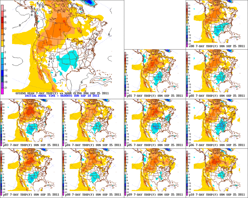
It looks like we are going to at least have normal temperatures thru the next 7 days! In fact GFS Ensembles Temperature Departures shows a good portion of North and Central Texas having below normal temperatures thru the next 7 days. By Thursday and Friday it looks like Dallas is going to have some trouble reaching 80F!! I think I have to move to the Texas Winter Thread! :lol:

6zGFS Ensembles Temperature Departures thru 7 days.
Image

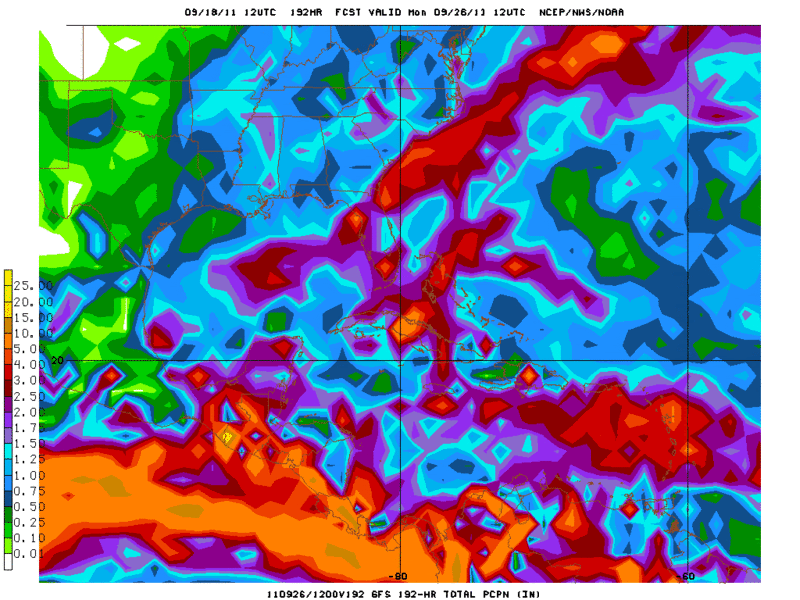
As far as rain goes the 12zGFS total precipitation thru 8 days does not show a whole lot but at least their is some green on Texas. The 12zECMWF has basically the same Rainfall amounts as the GFS thru 8 days.
Image
0 likes   
The following post is NOT an official forecast and should not be used as such. It is just the opinion of the poster and may or may not be backed by sound meteorological data. It is NOT endorsed by any professional institution including storm2k.org For Official Information please refer to the NHC and NWS products.

Shoshana
Category 5
Category 5
Posts: 1414
Joined: Thu Sep 09, 2004 7:50 pm
Location: NE Austin

#1242 Postby Shoshana » Sun Sep 18, 2011 5:59 pm

Ohhh. thunder! No rain tho.
0 likes   

Shoshana
Category 5
Category 5
Posts: 1414
Joined: Thu Sep 09, 2004 7:50 pm
Location: NE Austin

#1243 Postby Shoshana » Tue Sep 20, 2011 12:53 am

Never did get any rain. At all. Still don't have a rain gauge but the doggie pool stayed dry.
0 likes   

User avatar
South Texas Storms
Professional-Met
Professional-Met
Posts: 4224
Joined: Thu Jun 24, 2010 12:28 am
Location: Houston, TX

Re: C/S TX Weather: Extreme Fire Danger!

#1244 Postby South Texas Storms » Tue Sep 20, 2011 8:19 pm

Wow, it looks like my house in SA was in the bulls-eye for rainfall across most of Texas. My dad said we got about 5 inches of rain from this event and even some pea size hail with the storms on Sunday evening. PRAISE THE LORD!!!! :D :D :D :D
Hopefully more widespread rain is on the way soon for all of Texas!
0 likes   

User avatar
Ntxw
Storm2k Moderator
Storm2k Moderator
Posts: 22784
Joined: Wed Oct 21, 2009 6:34 pm
Location: DFW, Texas

#1245 Postby Ntxw » Wed Sep 21, 2011 10:33 am

Don't see significant statewide in the 7 days. Hilary in the EPAC could be of interest down the road. Lets pray she streams lots of moisture into Texas to at least spark storms...
0 likes   
The above post and any post by Ntxw is NOT an official forecast and should not be used as such. It is just the opinion of the poster and may or may not be backed by sound meteorological data. It is NOT endorsed by any professional institution including Storm2k. For official information, please refer to NWS products.

  Help support Storm2K!
Help Support Storm2K

User avatar
horselattitudesfarm
Category 1
Category 1
Posts: 315
Joined: Thu Jul 16, 2009 5:55 pm
Location: Asheville, NC (formerly from Dallas, TX)

Re: C/S TX Weather: Extreme Fire Danger!

#1246 Postby horselattitudesfarm » Thu Sep 22, 2011 9:11 pm

Latest forecast discussion:

"THERE IS STILL QUITE A BIT OF DISCREPANCY BETWEEN THE MODELS
HEADED INTO NEXT WEEK. THE UNCERTAINTY COMES FROM THE HANDLING OF
A PIECE OF ENERGY WHICH BREAKS OFF FROM A WEST COAST TROF AND
MOVES INTO THE 4-CORNERS REGION BY TUESDAY. THE GFS HAS OFFERED A
COUPLE OF SOLUTIONS FOR THIS FEATURE OVER THE LAST FEW RUNS. ONE
CUTS THIS DISTURBANCE OFF OVER TEXAS FOR A COUPLE OF DAYS BRINGING
BENEFICIAL RAINFALL WHILE THE OTHER INTERACTS IT WITH A TROPICAL
SYSTEM IN THE EASTERN PACIFIC WHICH WOULD RESULT IN CONTINUED DRY
CONDITIONS ACROSS TEXAS. GIVEN SOME SUPPORT FROM THE ECMWF...WILL LEAN
TOWARD A DRIER SOLUTION WITH THE UPPER LOW REMAINING WELL WEST OF
NORTH TEXAS. THIS SYSTEM WILL OF COURSE CONTINUE TO BE MONITORED
GIVEN THE POTENTIAL SIGNIFICANT RAINFALL CHANCES ASSOCIATED WITH
IT."

Which will it be?! Feelin' lucky?....should we bet?
0 likes   

User avatar
vbhoutex
Storm2k Executive
Storm2k Executive
Posts: 29112
Age: 73
Joined: Wed Oct 09, 2002 11:31 pm
Location: Cypress, TX
Contact:

Re: C/S TX Weather: Extreme Fire Danger!

#1247 Postby vbhoutex » Fri Sep 23, 2011 8:27 pm

This is the latest from Jeff Lindner. It affects portions of C/S TX also.

Fire Weather Watch has been issued for Sunday.

Elevated to near critical fire weather conditions will be felt on Sunday across the region.

Red Flag Warnings may be required.

Potential growing for wind driven wildfires on Sunday as strong SW winds of 15-25mph develop across the region and combine with afternoon RH values of 20-30%. While rains last weekend have resulted in some modest green up of surface grasses, overall fuels remain extremely dry and KBDI values continue above 700 or in the extremely dangerous range. While fire starts may be harder given the slight green up, if a fire develops strong winds will result in explosive and rapid growth. Fires over the past few months have shown rapid spread in pine forest plantation where (although green) the pines have become extremely flammable due to the drought conditions.

Worst conditions are expected along and north of a line from Columbus to Spring to Trinity especially in the area along a SE line from Austin to Columbus where rains did not fall last weekend.

Residents across the region should be aware of the fire weather conditions and have a wildfire plan in place and ready to use. You may only have minutes to gather your things and leave should a wildfire approach your area.

Extended:

Watching closely the extended range as another frontal boundary may head for the western Gulf mid next week and potentially interact with now powerful Hurricane Hillary in the eastern Pacific Ocean. This is a classic heavy rainfall pattern for Texas….if all the pieces can fall into the correct place. Still much uncertainty on where and how much of the moisture from this hurricane could be drawn NE across TX, but at this point there is at least some hope.
0 likes   
Skywarn, C.E.R.T.
Please click below to donate to STORM2K to help with the expenses of keeping the site going:
Image

Shoshana
Category 5
Category 5
Posts: 1414
Joined: Thu Sep 09, 2004 7:50 pm
Location: NE Austin

#1248 Postby Shoshana » Sun Sep 25, 2011 4:15 pm

(Mabry) Sun Day 86 100+ (New All Time Record)

Day 26 105+

27 in a row 100+ current record 2011!

(Bergstrom) Sun Day 72 100+ (New All Time Record)
0 likes   

Shoshana
Category 5
Category 5
Posts: 1414
Joined: Thu Sep 09, 2004 7:50 pm
Location: NE Austin

#1249 Postby Shoshana » Mon Sep 26, 2011 4:17 pm

(Mabry) Mon Day 87 100+ (New All Time Record)

Day 26 105+

27 in a row 100+ current record 2011!

(Bergstrom) Mon Day 72 100+ (New All Time Record)
0 likes   

Shoshana
Category 5
Category 5
Posts: 1414
Joined: Thu Sep 09, 2004 7:50 pm
Location: NE Austin

#1250 Postby Shoshana » Tue Sep 27, 2011 5:21 pm

Lookin kinda dark out! Saw lots of lightning but no rain yesterday/last night but I put my new rain gauge out anyway...


(Mabry) Tues Day 88 100+ (New All Time Record)

Day 26 105+

27 in a row 100+ current record 2011!

(Bergstrom) Mon Day 72 100+
0 likes   

SaskatchewanScreamer

#1251 Postby SaskatchewanScreamer » Tue Sep 27, 2011 6:40 pm

I hope some of you are keeping a special journal of this drought. Pictures/bills/temps/newspaper clippings etc included so you can show your grandchildren what your generation went through.
0 likes   

Shoshana
Category 5
Category 5
Posts: 1414
Joined: Thu Sep 09, 2004 7:50 pm
Location: NE Austin

#1252 Postby Shoshana » Tue Sep 27, 2011 7:31 pm

Seriously - I cannot believe that 2 days in a row I've watched storm clouds go right around our house.

grumble. No rain.
0 likes   

User avatar
gboudx
S2K Supporter
S2K Supporter
Posts: 4080
Joined: Thu Sep 04, 2003 1:39 pm
Location: Rockwall, Tx but from Harvey, La

Re:

#1253 Postby gboudx » Wed Sep 28, 2011 9:36 am

SaskatchewanScreamer wrote:I hope some of you are keeping a special journal of this drought. Pictures/bills/temps/newspaper clippings etc included so you can show your grandchildren what your generation went through.


Our grandchildren will probably be able to upload that info straight to their brain wirelessly. :)
0 likes   

SaskatchewanScreamer

Re: Re:

#1254 Postby SaskatchewanScreamer » Wed Sep 28, 2011 10:10 am

gboudx wrote:
SaskatchewanScreamer wrote:I hope some of you are keeping a special journal of this drought. Pictures/bills/temps/newspaper clippings etc included so you can show your grandchildren what your generation went through.


Our grandchildren will probably be able to upload that info straight to their brain wirelessly. :)


LOL how true but it won't be your story (plus real artifacts that one can touch are, at least to me, much more fascinating). Grandma and Grandpa took this pic/took the time to write their impressions in the journal/took the time to cut articles from their home town newspaper out and paste them in their book.

Their journal tells what they personally were focused on/worried about during trying times.
0 likes   

User avatar
Tireman4
S2K Supporter
S2K Supporter
Posts: 5853
Age: 59
Joined: Fri Jun 30, 2006 1:08 pm
Location: Humble, Texas
Contact:

Re: Re:

#1255 Postby Tireman4 » Wed Sep 28, 2011 11:27 am

SaskatchewanScreamer wrote:
gboudx wrote:
SaskatchewanScreamer wrote:I hope some of you are keeping a special journal of this drought. Pictures/bills/temps/newspaper clippings etc included so you can show your grandchildren what your generation went through.


Our grandchildren will probably be able to upload that info straight to their brain wirelessly. :)


LOL how true but it won't be your story (plus real artifacts that one can touch are, at least to me, much more fascinating). Grandma and Grandpa took this pic/took the time to write their impressions in the journal/took the time to cut articles from their home town newspaper out and paste them in their book.

Their journal tells what they personally were focused on/worried about during trying times.


Or for historians that might be researching it...
0 likes   

Shoshana
Category 5
Category 5
Posts: 1414
Joined: Thu Sep 09, 2004 7:50 pm
Location: NE Austin

#1256 Postby Shoshana » Wed Sep 28, 2011 11:29 pm

(Mabry) Wed Day 89 100+ (New All Time Record)

Day 26 105+

27 in a row 100+ current record 2011!

(Bergstrom) Wed Day 73 100+ (New All Time Record)
0 likes   

User avatar
Portastorm
Storm2k Moderator
Storm2k Moderator
Posts: 9914
Age: 63
Joined: Fri Jul 11, 2003 9:16 am
Location: Round Rock, TX
Contact:

Re: C/S TX Weather: Extreme Fire Danger!

#1257 Postby Portastorm » Thu Sep 29, 2011 12:57 pm

Unfortunately the fire danger looks to return with a vengeance tomorrow (Friday) after frontal passage. A Red Flag Warning has been issued for winds 20-30 mph out of the north-northeast and very dry humidity.

I hope we can escape any additional calamity like we did the other day when we had our last frontal passage.
0 likes   
Any forecasts under my name are to be taken with a grain of salt. Get your best forecasts from the National Weather Service and National Hurricane Center.

Shoshana
Category 5
Category 5
Posts: 1414
Joined: Thu Sep 09, 2004 7:50 pm
Location: NE Austin

#1258 Postby Shoshana » Thu Sep 29, 2011 2:48 pm

(Mabry) Thur Day 90 100+ (New All Time Record) New Daily High Record

Day 26 105+

27 in a row 100+ current record 2011!

(Bergstrom) Wed Day 73 100+ (New All Time Record) New Daily High Record
0 likes   

User avatar
somethingfunny
ChatStaff
ChatStaff
Posts: 3926
Age: 37
Joined: Thu May 31, 2007 10:30 pm
Location: McKinney, Texas

#1259 Postby somethingfunny » Thu Sep 29, 2011 3:46 pm

US National Weather Service Fort Worth Texas
Both DFW and Waco have hit 100 degrees today! Isolated to scattered showers and thunderstorms are developing across parts of north Texas, and the cold front will arrive in the next few hours. Quiet and pleasant weather is expected behind the front for the next 7 days.
1 · Like · · Share · 32 seconds ago

:(

Day 71 for DFW and Day 90 for Waco.
0 likes   
I am not a meteorologist, and any posts made by me are not official forecasts or to be interpreted as being intelligent. These posts are just my opinions and are probably silly opinions.

User avatar
Ntxw
Storm2k Moderator
Storm2k Moderator
Posts: 22784
Joined: Wed Oct 21, 2009 6:34 pm
Location: DFW, Texas

#1260 Postby Ntxw » Thu Sep 29, 2011 4:14 pm

I am hoping so bad for the scenario euro has about a week out. We need a pacific TC development early next week so that the predicted western trough can pull moisture due northeast into Texas. If only...

Image

Uploaded with ImageShack.us
0 likes   
The above post and any post by Ntxw is NOT an official forecast and should not be used as such. It is just the opinion of the poster and may or may not be backed by sound meteorological data. It is NOT endorsed by any professional institution including Storm2k. For official information, please refer to NWS products.


  Help support Storm2K!

Help Support Storm2K


Return to “USA & Caribbean Weather”

Who is online

Users browsing this forum: Brent, Brushcountry and 23 guests