I'm seeing HOPE. HIGHS in the 80s sometime next week for central Texas???
We've had more LOWS in the 80s this Summer than any other time since I have lived here. Ponder is still pretty consistent with his other Fall post of Mid-September.
https://youtu.be/7PgtSSxcNZA?si=t1nFNBLfCDBAD9UC
Texas Fall 2023
Moderator: S2k Moderators
Forum rules

The posts in this forum are NOT official forecast and should not be used as such. They are just the opinion of the poster and may or may not be backed by sound meteorological data. They are NOT endorsed by any professional institution or STORM2K.
-
weatherdude1108
- Category 5

- Posts: 4228
- Joined: Tue Dec 13, 2011 1:04 pm
- Location: Northwest Austin/Cedar Park, TX
Re: Texas Fall 2023
3 likes
The preceding post is NOT an official forecast, and should not be used as such. It is only the opinion of the poster and may or may not be backed by sound meteorological data. It is NOT endorsed by any professional institution including storm2k.org. For Official Information please refer to the NHC and NWS products.
-
Iceresistance

- Category 5
- Posts: 9590
- Age: 22
- Joined: Sat Oct 10, 2020 9:45 am
- Location: Tecumseh, OK/Norman, OK
Re: Texas Fall 2023
weatherdude1108 wrote:I'm seeing HOPE. HIGHS in the 80s sometime next week for central Texas???
We've had more LOWS in the 80s this Summer than any other time since I have lived here. Ponder is still pretty consistent with his other Fall post of Mid-September.
[youtube]https://youtu.be/7PgtSSxcNZA[/youtube]
Fixed the YT video for you
1 likes
Bill 2015 & Beta 2020
Winter 2020-2021
All observations are in Tecumseh, OK unless otherwise noted.
Winter posts are focused mainly for Oklahoma & Texas.
Take any of my forecasts with a grain of salt, refer to the NWS, SPC, and NHC for official information
Never say Never with weather! Because ANYTHING is possible!
Winter 2020-2021
All observations are in Tecumseh, OK unless otherwise noted.
Winter posts are focused mainly for Oklahoma & Texas.
Take any of my forecasts with a grain of salt, refer to the NWS, SPC, and NHC for official information
Never say Never with weather! Because ANYTHING is possible!
-
weatherdude1108
- Category 5
- Posts: 4228
- Joined: Tue Dec 13, 2011 1:04 pm
- Location: Northwest Austin/Cedar Park, TX
Re: Texas Fall 2023
Iceresistance wrote:weatherdude1108 wrote:I'm seeing HOPE. HIGHS in the 80s sometime next week for central Texas???
We've had more LOWS in the 80s this Summer than any other time since I have lived here. Ponder is still pretty consistent with his other Fall post of Mid-September.
https://youtu.be/7PgtSSxcNZA
Fixed the YT video for you
Thanks! I was wondering why I couldn't get it to work(?). It worked when I posted the last video. Thanks for your help!
1 likes
The preceding post is NOT an official forecast, and should not be used as such. It is only the opinion of the poster and may or may not be backed by sound meteorological data. It is NOT endorsed by any professional institution including storm2k.org. For Official Information please refer to the NHC and NWS products.
-
weatherdude1108
- Category 5
- Posts: 4228
- Joined: Tue Dec 13, 2011 1:04 pm
- Location: Northwest Austin/Cedar Park, TX
Re: Texas Fall 2023

2 likes
The preceding post is NOT an official forecast, and should not be used as such. It is only the opinion of the poster and may or may not be backed by sound meteorological data. It is NOT endorsed by any professional institution including storm2k.org. For Official Information please refer to the NHC and NWS products.
-
Portastorm

- Storm2k Moderator

- Posts: 9955
- Age: 63
- Joined: Fri Jul 11, 2003 9:16 am
- Location: Round Rock, TX
- Contact:
Re: Texas Fall 2023
Considering we've only had a tenth of an inch of precip literally in more than two months ... should that verify above ... would be like winning the lottery!
4 likes
Any forecasts under my name are to be taken with a grain of salt. Get your best forecasts from the National Weather Service and National Hurricane Center.
-
bubba hotep

- S2K Supporter

- Posts: 6014
- Joined: Wed Dec 28, 2016 1:00 am
- Location: Collin County Texas


-
weatherdude1108
- Category 5
- Posts: 4228
- Joined: Tue Dec 13, 2011 1:04 pm
- Location: Northwest Austin/Cedar Park, TX
Re: Texas Fall 2023


2 likes
The preceding post is NOT an official forecast, and should not be used as such. It is only the opinion of the poster and may or may not be backed by sound meteorological data. It is NOT endorsed by any professional institution including storm2k.org. For Official Information please refer to the NHC and NWS products.
-
weatherdude1108
- Category 5
- Posts: 4228
- Joined: Tue Dec 13, 2011 1:04 pm
- Location: Northwest Austin/Cedar Park, TX
Re: Texas Fall 2023
Portastorm wrote::uarrow:
Considering we've only had a tenth of an inch of precip literally in more than two months ... should that verify above ... would be like winning the lottery!
Yeah, I know right? Hasn't it been like four months since we got 1"? Or even 0.5"? Don't know the stats. I lost count of the number of days of heat/drought!
This pattern really started around Mid-June with the sun blasting the wet ground from Spring and early Summer rains of the moisture and creating those record number of Excessive Heat Warnings. We had a break with a week of normal 90s in early July, then the blast inferno kicked back in with merciless vengenance, and dewpoints gradually lowering and temps rising into the "feels like Arizona" territory of record 105+'s, creating the infamous self-perpetuating hot and dry feedback loop.
Then my Texas Summer S.A.D. kicked in as I kept reading the hopeless long-range models, with heat records from as far back as the 1920s that kept dropping.


Wouldn't notice it stepping outside right now, but based on the subtle differences in how it feels in the mornings and the models, I feel like a needed change is coming.


3 likes
The preceding post is NOT an official forecast, and should not be used as such. It is only the opinion of the poster and may or may not be backed by sound meteorological data. It is NOT endorsed by any professional institution including storm2k.org. For Official Information please refer to the NHC and NWS products.
-
South Texas Storms

- Professional-Met

- Posts: 4258
- Joined: Thu Jun 24, 2010 12:28 am
- Location: Houston, TX
Re: Texas Fall 2023
Confidence is increasing that this will finally be our last week seeing widespread 100 degree temperatures. I'm hopeful we'll see our first Fall cold front arrive sometime next week. If it reaches us like most models now show, rain chances and cooler temperatures should finally return! I'm so ready for it!
5 likes
-
weatherdude1108
- Category 5
- Posts: 4228
- Joined: Tue Dec 13, 2011 1:04 pm
- Location: Northwest Austin/Cedar Park, TX
Re: Texas Fall 2023
EWX says mid-60s for lows next Wednesday!
Their word, "fantastic". Area Forecast Discussion
National Weather Service Austin/San Antonio TX
252 PM CDT Tue Sep 5 2023
...New SHORT TERM, LONG TERM, FIRE WEATHER...
.SHORT TERM...
(Tonight through Wednesday night)
Issued at 230 PM CDT Tue Sep 5 2023
Weak cyclonic flow aloft along with daytime heating and the
seabreeze may be enough to kick off some isolated convection this
afternoon over portions of the coastal plains and Highway 77
corridor. Chances are low and will maintain 20% Pops in the forecast
in case a shower or storm manages to develop. Otherwise, hot
temperatures continue this afternoon and early evening with heat
index values peaking in the 104 to near 107 degree range this
afternoon. A Special Weather Statement for the elevated heat index
values remains in effect for portions of the Rio Grande plains and
counties along and east of the I-35 corridor through early evening.
It will be warm overnight with continued southeast and some patchy
morning cloud cover keeping lows generally in the 70s to lower 80s.
The weak area of cyclonic flow in the mid and upper levels continue
to drop into south Texas tomorrow. Any weak lift along with daytime
heating and adequate moisture may allow for some afternoon
convection to develop near the coastal plains. Some of the hi-res
models are also hinting at the possibility of convection developing
just north of our region tomorrow afternoon. If convection manages
to develop over northwest Texas along a cold front, then we may see
an outflow boundary drop southward toward portions of the Hill
Country tomorrow. If this occurs, we may need to add a low chance
for showers and storms to portions of the Hill country and nearby I-
35 corridor.
&&
.LONG TERM...
(Thursday through Tuesday)
Issued at 230 PM CDT Tue Sep 5 2023
The long term forecast begins with a warming trend and good
possibilities for heat headlines starting on Thursday through at
least Saturday across most areas of south central Texas. Thursday`s
highs are expected to range from the mid 90s across the southern
Edwards Plateau and up to 106 degrees along Interstate 35 and the
coastal plains. Heat index values could reach up to 111. Even hotter
conditions are forecast for Friday with highs in the upper 90s across
the southern Edwards Plateau and from 100 to 108 across the rest of
the local area with heat indices as high as 112.
Continued hot and humid on Saturday with highs in the upper 90s and
up to 106 with mostly sunny skies through mid afternoon. Clouds
could start developing mid to late afternoon into early evening as
an upper level short wave pushes down from central Texas into the
Hill Country. Can`t rule out a few showers and thunderstorms across
the Hill Country and areas along and east of a Fredericksburg, New
Braunfels to Cuero line. Otherwise, dry and hot.
By Sunday, the subtropical high weakens a bit and allows a few weak
disturbances to push down from central Texas to our local area along
the eastern periphery of the high. This scenario brings another
round of showers and thunderstorms for areas along and east of a
Fredericksburg, San Antonio and Karnes City line. Rainfall amounts
are likely limited with only a few places getting one tenth of an
inch or so.
Are you ready for cooler weather? We are guessing the answer is
affirmative. On that note, Monday`s highs are expected to be around
the mid to upper 90s with a few locations reaching the 100 degree
mark in addition to slight to low end chances for showers and
thunderstorms mainly across the Hill Country, I-35 corridor and the
coastal plains. A cold front is forecast to push across the local
area on Tuesday with chances for showers and thunderstorms across
most of south central Texas. Tuesday`s highs across some parts of
the Hill Country and southern Edwards Plateau to only reach the
upper 80s while the rest of the local area stays in the low to mid
90s. Overnight lows will feel fantastic Wednesday morning as
temperatures drop to the mid 60s.
1 likes
The preceding post is NOT an official forecast, and should not be used as such. It is only the opinion of the poster and may or may not be backed by sound meteorological data. It is NOT endorsed by any professional institution including storm2k.org. For Official Information please refer to the NHC and NWS products.

Re: Texas Fall 2023
I don't want to jinx it...but models have cooler air!! Maybe Fall-ish feel. Like several have mentioned...cannot wait.
4 likes
The above post and any post by Ntxw is NOT an official forecast and should not be used as such. It is just the opinion of the poster and may or may not be backed by sound meteorological data. It is NOT endorsed by any professional institution including Storm2k. For official information, please refer to NWS products.
Help support Storm2K!
-
Iceresistance
- Category 5
- Posts: 9590
- Age: 22
- Joined: Sat Oct 10, 2020 9:45 am
- Location: Tecumseh, OK/Norman, OK
Re: Texas Fall 2023
1 likes
Bill 2015 & Beta 2020
Winter 2020-2021
All observations are in Tecumseh, OK unless otherwise noted.
Winter posts are focused mainly for Oklahoma & Texas.
Take any of my forecasts with a grain of salt, refer to the NWS, SPC, and NHC for official information
Never say Never with weather! Because ANYTHING is possible!
Winter 2020-2021
All observations are in Tecumseh, OK unless otherwise noted.
Winter posts are focused mainly for Oklahoma & Texas.
Take any of my forecasts with a grain of salt, refer to the NWS, SPC, and NHC for official information
Never say Never with weather! Because ANYTHING is possible!
-
rwfromkansas
- Category 5
- Posts: 3038
- Joined: Sat Aug 27, 2005 12:47 am
- Location: North Fort Worth
Re: Texas Fall 2023
We want to walk into this quietly so not to scare the heat ridge buster away. The cold front is real skiddish. We need to act like we are sneaking in without our parents knowing we went to a party.
In all seriousness, it’s getting exciting a bit since everybody is on board, Evan Andrews, NWS, Ponder (not a degreed met but did a great job with this).
Make it so.
Of course, I will go to San Diego next week where they will be hot instead. Lol. Of course, their hot is 83. Big whoop.
In all seriousness, it’s getting exciting a bit since everybody is on board, Evan Andrews, NWS, Ponder (not a degreed met but did a great job with this).
Make it so.
Of course, I will go to San Diego next week where they will be hot instead. Lol. Of course, their hot is 83. Big whoop.
3 likes
-
ElectricStorm

- Category 5
- Posts: 5147
- Age: 25
- Joined: Tue Aug 13, 2019 11:23 pm
- Location: Norman, OK
Re: Texas Fall 2023
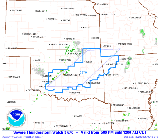
Severe thunderstorm watch is up here in the marginal risk with storms just to my west. Hopefully will get something decent
1 likes
B.S Meteorology, University of Oklahoma '25
Please refer to the NHC, NWS, or SPC for official information.
Please refer to the NHC, NWS, or SPC for official information.
-
Iceresistance
- Category 5
- Posts: 9590
- Age: 22
- Joined: Sat Oct 10, 2020 9:45 am
- Location: Tecumseh, OK/Norman, OK
Re: Texas Fall 2023
Storms getting closer...
2 likes
Bill 2015 & Beta 2020
Winter 2020-2021
All observations are in Tecumseh, OK unless otherwise noted.
Winter posts are focused mainly for Oklahoma & Texas.
Take any of my forecasts with a grain of salt, refer to the NWS, SPC, and NHC for official information
Never say Never with weather! Because ANYTHING is possible!
Winter 2020-2021
All observations are in Tecumseh, OK unless otherwise noted.
Winter posts are focused mainly for Oklahoma & Texas.
Take any of my forecasts with a grain of salt, refer to the NWS, SPC, and NHC for official information
Never say Never with weather! Because ANYTHING is possible!
-
tajmahal
- Tropical Storm

- Posts: 168
- Age: 68
- Joined: Tue Jan 10, 2012 10:09 am
- Location: Austin, TX area & eastern Africa
Re: Texas Fall 2023
Today's high temperature at Austin Camp Mabry was 104°, which tied for the 12th hottest September temperature on record. Today's average temperature of 91.5° tied for the seventh hottest on record for September. Today's low temperature of 79° tied for the sixth warmest on record for September.
But it could have been worse today, like the 112° on this date in 2000.
But it could have been worse today, like the 112° on this date in 2000.
1 likes
-
tajmahal
- Tropical Storm
- Posts: 168
- Age: 68
- Joined: Tue Jan 10, 2012 10:09 am
- Location: Austin, TX area & eastern Africa
Re: Texas Fall 2023
weatherdude1108 wrote:I'm seeing HOPE. HIGHS in the 80s sometime next week for central Texas???
We've had more LOWS in the 80s this Summer than any other time since I have lived here. Ponder is still pretty consistent with his other Fall post of Mid-September.
https://youtu.be/7PgtSSxcNZA?si=t1nFNBLfCDBAD9UC
Austin Camp Mabry so far this year has had 15 days with 80° or warmer low temperatures. The previous record was 10 days in 2020.
0 likes
-
Brent
- S2K Supporter
- Posts: 38753
- Age: 37
- Joined: Sun May 16, 2004 10:30 pm
- Location: Tulsa Oklahoma
- Contact:
Re: Texas Fall 2023
Well I missed the rain by a few miles but still nice to see the beginnings of something besides heat and humidity
0 likes
#neversummer

Re: Texas Fall 2023
tajmahal wrote:Ptarmigan wrote:El Nino effect in the summer can go either way.
Or have no effect at all.
Very true. The correlation of El Nino and summer is weak.
0 likes