
Texas Fall-2015
Moderator: S2k Moderators
Forum rules

The posts in this forum are NOT official forecast and should not be used as such. They are just the opinion of the poster and may or may not be backed by sound meteorological data. They are NOT endorsed by any professional institution or STORM2K.
-
Brent
- S2K Supporter

- Posts: 38759
- Age: 37
- Joined: Sun May 16, 2004 10:30 pm
- Location: Tulsa Oklahoma
- Contact:
Re: Texas Fall-2015
Also from the 12z GFS... rain continues well into Monday for most of the state due to a slow moving low along the Texas coast and then there's another rain event(this one would be quite chilly) around Halloween.
0 likes
#neversummer

Re: Re:
gboudx wrote:Texas Snowman wrote::uarrow: Texas and Kansas State are scheduled to play at 11 a.m. on Saturday in Austin. Wonder what effect all of this will have on the game/crowd?
Maybe they have to cancel the game if there is bad flooding in the ATX area. My LSU Tigers had their 1st game cancelled but that was because of persistent lightning which was pushing game time to start near midnight. Officials decided to cancel. Recently South Carolina had to move their "home" game with LSU to Tiger Stadium in Baton Rouge due to the flooding over there. It may depend on if both teams can manage a reschedule. But chances are, the game is played in a downpour. Too much money at stake for UT to miss a home game.
And that cancelling might have cost Fournette a chance to eclipse 2000 yards. Off topic, but dude is a beast, a generational freak, Bo, Heschel, Fournette.
back to your regularly scheduled flooding talks.
0 likes
The above post and any post by dhweather is NOT an official forecast and should not be used as such. It is just the opinion of the poster and may or may not be backed by sound meteorological data. It is NOT endorsed by any professional institution including storm2k.org. For official information, please refer to NWS products.

Re:
1900hurricane wrote:Formula 1 is also in Austin this weekend. Could be a huge issue.
I have a co-worker who is making the trip to Austin for the race this weekend, what a shame, made the plans for race months ago.
BTW, I see that the GFS is not backing down with the torrential episode, wow!
0 likes
-
Portastorm

- Storm2k Moderator

- Posts: 9955
- Age: 63
- Joined: Fri Jul 11, 2003 9:16 am
- Location: Round Rock, TX
- Contact:
Re: Texas Fall-2015
Some thoughts from ATX on previous posts:
* F1 will race in rain. Light to moderate showers are no big deals to these guys. It impacts the type of tires they use and strategies but otherwise they will race. What would cause delays would be lightning and/or very heavy rainfall. Based on what we are seeing, I think those are distinct possibilities Saturday morning into afternoon for the qualifying runs. Sunday should be okay. I don't buy into the GFS moving that coastal low inland. Rains should be tapering off on Sunday.
** The UT-K State game. Now that could be bad. I would expect very blustery conditions with heavy rain off and on, probably lightning causing delays, and downright miserableness for all at DKR Stadium. If the kickoff is delayed into late afternoon it wouldn't surprise me at all.
*** I'm thinking you Metroplexers and areas southwest of you into west central Texas will see the rainfall maxima for this event. Probably 3-4" down here. The "fly in the ointment" as srainhoutx would say is the coastal low. If it develops and moves northeast along the coast it will probably steal moisture and diminish projected rainfall amounts. If not, some of those 10"+ predictions for certain areas may indeed verify.
0 likes
Any forecasts under my name are to be taken with a grain of salt. Get your best forecasts from the National Weather Service and National Hurricane Center.
-
weatherdude1108
- Category 5

- Posts: 4228
- Joined: Tue Dec 13, 2011 1:04 pm
- Location: Northwest Austin/Cedar Park, TX
Re: Texas Fall-2015
Portastorm wrote:Some thoughts from ATX on previous posts:
* F1 will race in rain. Light to moderate showers are no big deals to these guys. It impacts the type of tires they use and strategies but otherwise they will race. What would cause delays would be lightning and/or very heavy rainfall. Based on what we are seeing, I think those are distinct possibilities Saturday morning into afternoon for the qualifying runs. Sunday should be okay. I don't buy into the GFS moving that coastal low inland. Rains should be tapering off on Sunday.
** The UT-K State game. Now that could be bad. I would expect very blustery conditions with heavy rain off and on, probably lightning causing delays, and downright miserableness for all at DKR Stadium. If the kickoff is delayed into late afternoon it wouldn't surprise me at all.
*** I'm thinking you Metroplexers and areas southwest of you into west central Texas will see the rainfall maxima for this event. Probably 3-4" down here. The "fly in the ointment" as srainhoutx would say is the coastal low. If it develops and moves northeast along the coast it will probably steal moisture and diminish projected rainfall amounts. If not, some of those 10"+ predictions for certain areas may indeed verify.
Yeah, I'm wondering about the coastal low. That would be one of the things that busts this high QPF prediction. But there is also a ton of moisture associated with Patricia.
EWX issued a FFW.
FLOOD WATCH
NATIONAL WEATHER SERVICE AUSTIN/SAN ANTONIO TX
1202 PM CDT THU OCT 22 2015
...HEAVY RAIN WILL LEAD TO FLASH FLOODING ACROSS SOUTH CENTRAL
TEXAS FRIDAY AND SATURDAY...
.A COMBINATION OF DEEP LOW LEVEL MOISTURE FROM THE GULF OF
MEXICO...MID-LEVEL MOISTURE FROM THE PACIFIC...AN UPPER LEVEL
TROUGH...AND A SURFACE COLD FRONT WILL BRING HEAVY RAINFALL TO
SOUTH CENTRAL TEXAS. LOCALLY HEAVY RAIN WILL BEGIN TONIGHT AND
CONTINUE THROUGH SUNDAY MORNING. THE TIMING AND LOCATION OF THE
HEAVIEST RAIN ARE STILL UNCERTAIN AT THIS TIME. THE BEST LOCATION
FOR HEAVY RAIN LOOKS TO BE ACROSS THE EASTERN HALF OF SOUTH
CENTRAL TEXAS AND THE BEST TIME LOOKS LIKE FRIDAY NIGHT AND
SATURDAY. SOME AREAS OF LOCALLY HEAVY RAIN ARE POSSIBLE TONIGHT
AND COULD LEAD TO FLASH FLOODING BY FRIDAY MORNING. THE BEST
CHANCES TONIGHT SHOULD BE NORTH OF A LINE FROM ROCKSPRINGS TO
KERRVILLE TO BURNET AS AN UPPER DISTURBANCE MOVES ACROSS. AS THE
TROPICAL MOISTURE MOVES IN FROM THE SOUTHWEST...THE FOCUS WILL
SHIFT TO THE EASTERN HALF OF THE AREA FRIDAY AND SATURDAY.
RAINFALL TOTALS FOR THE EVENT ARE EXPECTED TO BE 4 TO 8 INCHES
WITH ISOLATED AMOUNTS OF 10 TO 12 INCHES POSSIBLE. SLOW
MOVING...TRAINING STORMS COULD LEAD TO 2 TO 3 INCHES OF RAIN IN A
SHORT PERIOD OF TIME IN SPOTS.
TXZ171>173-183>194-202>209-217>225-228-231230-
/O.NEW.KEWX.FF.A.0018.151023T1200Z-151025T1200Z/
/00000.0.ER.000000T0000Z.000000T0000Z.000000T0000Z.OO/
LLANO-BURNET-WILLIAMSON-VAL VERDE-EDWARDS-REAL-KERR-BANDERA-
GILLESPIE-KENDALL-BLANCO-HAYS-TRAVIS-BASTROP-LEE-KINNEY-UVALDE-
MEDINA-BEXAR-COMAL-GUADALUPE-CALDWELL-FAYETTE-MAVERICK-ZAVALA-
FRIO-ATASCOSA-WILSON-KARNES-GONZALES-DE WITT-LAVACA-DIMMIT-
INCLUDING THE CITIES OF...LLANO...BURNET...GEORGETOWN...DEL RIO...
ROCKSPRINGS...LEAKEY...KERRVILLE...BANDERA...FREDERICKSBURG...
BOERNE...BLANCO...SAN MARCOS...AUSTIN...BASTROP...GIDDINGS...
BRACKETTVILLE...UVALDE...HONDO...SAN ANTONIO...NEW BRAUNFELS...
SEGUIN...LOCKHART...LA GRANGE...EAGLE PASS...CRYSTAL CITY...
PEARSALL...PLEASANTON...FLORESVILLE...KARNES CITY...GONZALES...
CUERO...HALLETTSVILLE...CARRIZO SPRINGS
1202 PM CDT THU OCT 22 2015
...FLASH FLOOD WATCH IN EFFECT FROM FRIDAY MORNING THROUGH SUNDAY
MORNING...
THE NATIONAL WEATHER SERVICE IN AUSTIN/SAN ANTONIO HAS ISSUED A
* FLASH FLOOD WATCH FOR A PORTION OF SOUTH CENTRAL TEXAS...
INCLUDING THE FOLLOWING COUNTIES...ATASCOSA...BANDERA...BASTROP...
BEXAR...BLANCO...BURNET...CALDWELL...COMAL...DE WITT...
DIMMIT...EDWARDS...FAYETTE...FRIO...GILLESPIE...GONZALES...
GUADALUPE...HAYS...KARNES...KENDALL...KERR...KINNEY...LAVACA...
LEE...LLANO...MAVERICK...MEDINA...REAL...TRAVIS...UVALDE... VAL
VERDE...WILLIAMSON...WILSON AND ZAVALA.
* FROM FRIDAY MORNING THROUGH SUNDAY MORNING
* FOR HEAVY RAINFALL OF 4 TO 8 INCHES WITH ISOLATED TOTALS OF 10
TO 12 INCHES.
* HEAVY RAIN WILL LEAD TO FLASH FLOODING OF ROADS...LOW LYING
AREAS...CREEKS...AND STREAMS. THERE IS ALSO A THREAT FOR SOME
MINOR TO MODERATE RIVER FLOODING.
PRECAUTIONARY/PREPAREDNESS ACTIONS...
A FLASH FLOOD WATCH MEANS FLASH FLOODING IS POSSIBLE IN OR NEAR
THE WATCH AREA. IF YOU ARE IN THE WATCH AREA...PLAN NOW FOR WHAT
YOU WILL DO IF FLASH FLOODING DEVELOPS. STAY INFORMED AND BE
READY TO ACT IF YOU SEE FLOODING OR IF A FLASH FLOOD WARNING IS
ISSUED.
0 likes
The preceding post is NOT an official forecast, and should not be used as such. It is only the opinion of the poster and may or may not be backed by sound meteorological data. It is NOT endorsed by any professional institution including storm2k.org. For Official Information please refer to the NHC and NWS products.

-
Portastorm
- Storm2k Moderator
- Posts: 9955
- Age: 63
- Joined: Fri Jul 11, 2003 9:16 am
- Location: Round Rock, TX
- Contact:
Re:
JayDT wrote:How is the Euro looking? I just saw a comment Larry Cosgrove posted a few minutes ago about the Euro, and he says "European model blasts Texas", especially eastern half of the state.
It's really not that different from the 0z run. A large swath of heavy rain (anywhere from 4-12") north to south in the middle half of the state, namely the I-35 corridor. It does provide some heavy rainfall totals in the coastal plains into the Houston area later in the weekend.
0 likes
Any forecasts under my name are to be taken with a grain of salt. Get your best forecasts from the National Weather Service and National Hurricane Center.
Re: Re:
Portastorm wrote:JayDT wrote:How is the Euro looking? I just saw a comment Larry Cosgrove posted a few minutes ago about the Euro, and he says "European model blasts Texas", especially eastern half of the state.
It's really not that different from the 0z run. A large swath of heavy rain (anywhere from 4-12") north to south in the middle half of the state, namely the I-35 corridor. It does provide some heavy rainfall totals in the coastal plains into the Houston area later in the weekend.
Ohh ok. I thought there had been a big change on it. So pretty much the area to look at for the biggest totals is gonna be along and around the I-35 corridor?
0 likes
-
CaptinCrunch

- S2K Supporter
- Posts: 8780
- Age: 58
- Joined: Mon Nov 03, 2003 4:33 pm
- Location: Kennedale, TX (Tarrant Co.)
Re: Texas Fall-2015
Afternoon AFD NWS FTW

.UPDATE...
MINOR UPDATE TO TRIM DOWN POPS INTO CHANCE CATEGORY EAST OF A
SHERMAN...DALLAS...CAMERON LINE. ACTIVITY ACROSS THIS AREA IS NOT
AS EXPANSIVE AS MANY HIGH RESOLUTION MODELS INDICATED IT WOULD BE
BY MIDDAY INTO EARLY AFTERNOON. LIKELY TO CATEGORICAL POPS WILL
CONTINUE WITH CONVECTION CONTAINING POCKETS OF HEAVIER RAIN NORTHWEST
OF A COMANCHE...MINERAL WELLS...GAINESVILLE LINE THROUGH THIS
AFTERNOON AND EARLY EVENING.
IF ISOLATED SMALL STREAM OR FLASH FLOODING WERE TO OCCUR TODAY...
IT WOULD BE ACROSS THOSE FAR NORTHWEST COUNTIES. THIS WOULD IMPACT
UPPER BRAZOS AND WEST ELM FORK OF THE TRINITY WITH POSSIBLE MINOR
RISES. BEING THAT WE`VE BEEN SO DRY UP TO THIS POINT THE PAST FEW
MONTHS...MUCH OF THIS AREA CAN TAKE THE RAIN AS LONG AS RATES REMAIN
REASONABLE WITH HEAVIER POCKETS OF RAIN CONTINUING TO MOVE READILY
NORTH. TRAINING MAY POSE A PROBLEM AS WELL...AS THIS AREA WILL NOT
MOVE MUCH FURTHER EAST THE REMAINDER OF THE DAY.
TODAY/S HIGH TEMPERATURES WERE LOWERED ACROSS THE W/NW COUNTIES
WITH THE CURRENT RAINFALL AND CLOUD COVER...WITH WARMEST
TEMPERATURES EXPECTED ACROSS THE FAR EASTERN COUNTIES WHERE PEEKS
OF SUN ARE STILL EXPECTED THIS AFTERNOON.
0 likes
-
vbhoutex

- Storm2k Executive

- Posts: 29149
- Age: 74
- Joined: Wed Oct 09, 2002 11:31 pm
- Location: Cypress, TX
- Contact:
Re: Texas Fall-2015
Latest from Jeff Lindner for SE TX area:
NOT liking the possibilities for our area or for the rest of Texas, even though we all need rain.
High tide coastal flooding occurring late this morning.
Increase in winds overnight and early this morning has forced more water against the coast with the morning high tide having produced coastal flooding in portions of Harris County and on the Bolivar Peninsula. Expect tidal conditions to remain similar Friday and Saturday with an increase on Sunday.
Now intense (category 4) hurricane Patricia is expected to strike the Mexican west coast and turn NNE to NE with upper level energy moving into TX Sunday. Forecast models are attempting to deepen a surface low along the TX coast in response to the strong upper level energy from Patricia on Sunday. This will only serve to enhance already high rainfall totals and increase coastal winds.
Concern is growing that coastal tides will increase another 1.0-1.5 ft on Sunday which will place us into flood warning levels at many locations along the coast…including Bolivar, west end of Galveston Island, Clear Lake/Kemah/Seabrook. There is still a lot of uncertainty on how this will play out, but persons should be aware of the potential for coastal flooding and impassable roadways near the coast this weekend.
Will be taking a close look at things this evening with respect to this weekend.
NOT liking the possibilities for our area or for the rest of Texas, even though we all need rain.
0 likes
Skywarn, C.E.R.T.
Please click below to donate to STORM2K to help with the expenses of keeping the site going:

Please click below to donate to STORM2K to help with the expenses of keeping the site going:
-
weatherdude1108
- Category 5
- Posts: 4228
- Joined: Tue Dec 13, 2011 1:04 pm
- Location: Northwest Austin/Cedar Park, TX
Our local weatherman showed a big swath of 5"-10" rains for the area. He even showed a 25.5" bullseye around Waco. He said he has never seen that much rain on a model before. He said that means it is picking up on something.
I'm not buying 25.5". I think I agree with Porta on 3-4" (if that). But I'm not sure. Depends on what happens with the coastal low. I just need a good soaking rain right now for the dry ground.
With all the hype, I'll bet we're lucky if we get one inch out of this whole thing.

I'm not buying 25.5". I think I agree with Porta on 3-4" (if that). But I'm not sure. Depends on what happens with the coastal low. I just need a good soaking rain right now for the dry ground.
With all the hype, I'll bet we're lucky if we get one inch out of this whole thing.
0 likes
The preceding post is NOT an official forecast, and should not be used as such. It is only the opinion of the poster and may or may not be backed by sound meteorological data. It is NOT endorsed by any professional institution including storm2k.org. For Official Information please refer to the NHC and NWS products.
-
Portastorm
- Storm2k Moderator
- Posts: 9955
- Age: 63
- Joined: Fri Jul 11, 2003 9:16 am
- Location: Round Rock, TX
- Contact:
Re:
weatherdude1108 wrote:Our local weatherman showed a big swath of 5"-10" rains for the area. He even showed a 25.5" bullseye around Waco. He said he has never seen that much rain on a model before. He said that means it is picking up on something.
I'm not buying 25.5". I think I agree with Porta on 3-4" (if that). But I'm not sure. Depends on what happens with the coastal low. I just need a good soaking rain right now for the dry ground.
With all the hype, I'll bet we're lucky if we get one inch out of this whole thing.
With all due respect, if a person is forecasting weather and cannot explain what the "something" is which the model may be picking up on ... then I personally wouldn't trust what they say.
The "players on the field" have been clearly defined. The questions now revolve around how fast does the front/trough move? Does a coastal low develop? Where does it move and how much inland moisture will it take with it, if any? Hurricane Patricia's direction and moisture flow? As it is, the 12z Euro is already wrong for the amount of rainfall it showed happening today in the AUS metro area. We are heading into a situation driven by mesoscale interactions.
0 likes
Any forecasts under my name are to be taken with a grain of salt. Get your best forecasts from the National Weather Service and National Hurricane Center.
-
weatherdude1108
- Category 5
- Posts: 4228
- Joined: Tue Dec 13, 2011 1:04 pm
- Location: Northwest Austin/Cedar Park, TX
Re: Re:
Portastorm wrote:weatherdude1108 wrote:Our local weatherman showed a big swath of 5"-10" rains for the area. He even showed a 25.5" bullseye around Waco. He said he has never seen that much rain on a model before. He said that means it is picking up on something.
I'm not buying 25.5". I think I agree with Porta on 3-4" (if that). But I'm not sure. Depends on what happens with the coastal low. I just need a good soaking rain right now for the dry ground.
With all the hype, I'll bet we're lucky if we get one inch out of this whole thing.
With all due respect, if a person is forecasting weather and cannot explain what the "something" is which the model may be picking up on ... then I personally wouldn't trust what they say.
The "players on the field" have been clearly defined. The questions now revolve around how fast does the front/trough move? Does a coastal low develop? Where does it move and how much inland moisture will it take with it, if any? Hurricane Patricia's direction and moisture flow? As it is, the 12z Euro is already wrong for the amount of rainfall it showed happening today in the AUS metro area. We are heading into a situation driven by mesoscale interactions.
After checking the link, I got that wrong. He said (paraphrasing) he wouldn't hold his breath and the bullseye can be off by 50-100 miles, and anytime you see something like that, "it does mean we need to take this situation very seriously."
Sorry about that.
The "picking up on something" was my silly novice interpretation, and not what he actually said.
http://kxan.com/2014/02/25/daily-forecast-2/
0 likes
The preceding post is NOT an official forecast, and should not be used as such. It is only the opinion of the poster and may or may not be backed by sound meteorological data. It is NOT endorsed by any professional institution including storm2k.org. For Official Information please refer to the NHC and NWS products.
-
weatherdude1108
- Category 5
- Posts: 4228
- Joined: Tue Dec 13, 2011 1:04 pm
- Location: Northwest Austin/Cedar Park, TX
Not nearly as long an EWX discussion as those of recent. I guess we'll see how the mesoscale interactions play out as Portastorm noted.
AREA FORECAST DISCUSSION
NATIONAL WEATHER SERVICE AUSTIN/SAN ANTONIO TX
254 PM CDT THU OCT 22 2015
.SHORT TERM (TODAY THROUGH SUNDAY)... UPPER AIR ANALYSIS THIS
MORNING SHOWED A LOW CENTERED OVER THE FOUR CORNERS REGION AND THE
FLOW ACROSS TEXAS WAS FROM THE SOUTHWEST. THIS FLOW IS BRINGING
MID- LEVEL MOISTURE UP ACROSS MEXICO FROM THE PACIFIC. AT THE
SURFACE...A FRONTAL BOUNDARY WAS DRAPED ACROSS WEST TEXAS FROM THE
NORTHERN PANHANDLE TO THE BIG BEND. CLOSER TO HOME WINDS WERE FROM
THE SOUTHEAST AND DEW POINT TEMPERATURES WERE GENERALLY IN THE
LOWER 70S WHICH IS 1-3 DEGREES HIGHER THAN 24 HOURS AGO. HURRICANE
PATRICIA IS OFF THE PACIFIC COAST OF MEXICO MOVING TOWARD THE
WEST-NORTHWEST. THIS COMBINATION OF DEEP LOW LEVEL MOISTURE FROM
THE GULF OF MEXICO...MID-LEVEL MOISTURE FROM THE PACIFIC...AN
UPPER LEVEL TROUGH...AND A SURFACE COLD FRONT WILL BRING HEAVY
RAINFALL TO SOUTH CENTRAL TEXAS. LOCALLY HEAVY RAIN WILL BEGIN
TONIGHT AND CONTINUE THROUGH SUNDAY MORNING. SOME AREAS OF LOCALLY
HEAVY RAIN ARE POSSIBLE TONIGHT AND COULD LEAD TO FLASH FLOODING
BY FRIDAY MORNING. THE BEST CHANCES TONIGHT SHOULD BE NORTH OF A
LINE FROM ROCKSPRINGS TO KERRVILLE TO BURNET AS THE UPPER
DISTURBANCE MOVES ACROSS. AS THE TROPICAL MOISTURE MOVES IN FROM
THE SOUTHWEST...THE FOCUS WILL SHIFT TO THE EASTERN HALF OF THE
AREA FRIDAY AND SATURDAY. RAINFALL TOTALS FOR THE EVENT ARE
EXPECTED TO BE 4 TO 8 INCHES WITH ISOLATED AMOUNTS OF 10 TO 12
INCHES POSSIBLE. SLOW MOVING...TRAINING STORMS COULD LEAD TO 2 TO
3 INCHES OF RAIN IN A SHORT PERIOD OF TIME IN SPOTS.
&&
.LONG TERM (SUNDAY NIGHT THROUGH WEDNESDAY)...
THE UPPER TROUGH WILL MOVE TO THE EAST. SOME SHOWERS AND
THUNDERSTORMS WILL LINGER OVER THE EAST MONDAY AND TUESDAY AS IT
MOVES AWAY. SOME WEAK RIDGING WILL BRING DRIER WEATHER FOR THE
MIDDLE OF THE WEEK.
0 likes
The preceding post is NOT an official forecast, and should not be used as such. It is only the opinion of the poster and may or may not be backed by sound meteorological data. It is NOT endorsed by any professional institution including storm2k.org. For Official Information please refer to the NHC and NWS products.

Lets not jump to conclusions too fast. Pegged heaviest rains is Friday and Saturday. Any you get now consider it bonus. Lets wait on the bust calls until Sunday.
0 likes
The above post and any post by Ntxw is NOT an official forecast and should not be used as such. It is just the opinion of the poster and may or may not be backed by sound meteorological data. It is NOT endorsed by any professional institution including Storm2k. For official information, please refer to NWS products.
Help support Storm2K!
Re: Texas Fall-2015

0 likes
The above post and any post by dhweather is NOT an official forecast and should not be used as such. It is just the opinion of the poster and may or may not be backed by sound meteorological data. It is NOT endorsed by any professional institution including storm2k.org. For official information, please refer to NWS products.
Re: Texas Fall-2015
18Z 4KM NAM - very wet

0 likes
The above post and any post by dhweather is NOT an official forecast and should not be used as such. It is just the opinion of the poster and may or may not be backed by sound meteorological data. It is NOT endorsed by any professional institution including storm2k.org. For official information, please refer to NWS products.
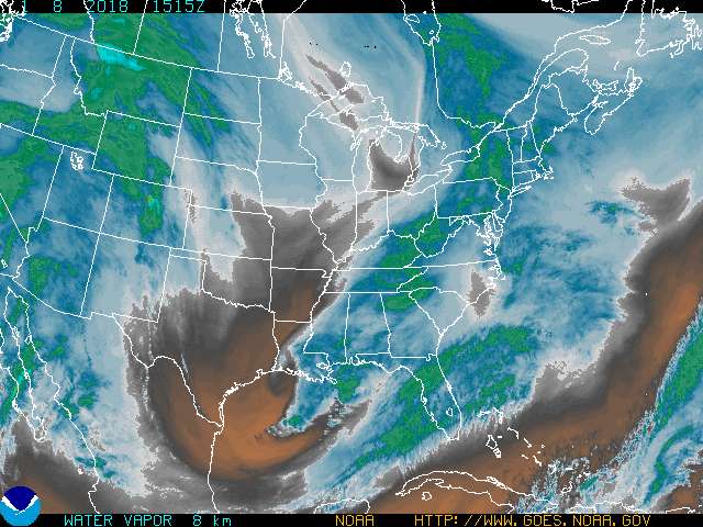
Re: Texas Fall-2015
I would never expect major rains coming based solely on this WV image, great deal of dry air to our south & particularly southwest
0 likes
The above post and any post by dhweather is NOT an official forecast and should not be used as such. It is just the opinion of the poster and may or may not be backed by sound meteorological data. It is NOT endorsed by any professional institution including storm2k.org. For official information, please refer to NWS products.

Re: Texas Fall-2015
Im thinking the coast of texas should be under the gun more due to the track of patricia? But i may be wrong it looks like the models bring this over the Victoria area whatever is left
0 likes
Re: Texas Fall-2015
18Z RGEM might be closest to what we can realistically expect, 4-6" with isolated 8+" totals. That's still a lot of water in a relatively short time. Flash flooding will still be an issue.
As Porta noted, there are mesoscale features we simply cannot forecast for certain, such as a coastal low.

As Porta noted, there are mesoscale features we simply cannot forecast for certain, such as a coastal low.
0 likes
The above post and any post by dhweather is NOT an official forecast and should not be used as such. It is just the opinion of the poster and may or may not be backed by sound meteorological data. It is NOT endorsed by any professional institution including storm2k.org. For official information, please refer to NWS products.
Return to “USA & Caribbean Weather”
Who is online
Users browsing this forum: cstrunk, South Texas Storms and 163 guests