rwfromkansas wrote:What looked like the first stretch of real 90s for DFW has evaporated in the humidity to just upper 90s now. And really just one day.
FWIW, last summer started off similarly. It will only "evaporate" for so long until it doesn't.
That said, today's high overachieved by several degrees above the forecast thanks to an unexpected scattering of clouds this afternoon. I imagine there's the possibility of the same happening Tuesday & Wednesday as well.
Re: Texas Spring 2024
Posted: Sun May 05, 2024 8:08 pm
by rwfromkansas
snownado wrote:
rwfromkansas wrote:What looked like the first stretch of real 90s for DFW has evaporated in the humidity to just upper 90s now. And really just one day.
FWIW, last summer started off similarly. It will only "evaporate" for so long until it doesn't.
That said, today's high overachieved by several degrees above the forecast thanks to an unexpected scattering of clouds this afternoon. I imagine there's the possibility of the same happening Tuesday & Wednesday as well.
I do remember the hopes of a cool summer last year for the same reason. But once the heat ridge took hold, it cooked us so much the rain didn’t matter. The cooling effect of moisture only lasts so long….
Re: Texas Spring 2024
Posted: Sun May 05, 2024 8:38 pm
by snownado
rwfromkansas wrote:
snownado wrote:
rwfromkansas wrote:What looked like the first stretch of real 90s for DFW has evaporated in the humidity to just upper 90s now. And really just one day.
FWIW, last summer started off similarly. It will only "evaporate" for so long until it doesn't.
That said, today's high overachieved by several degrees above the forecast thanks to an unexpected scattering of clouds this afternoon. I imagine there's the possibility of the same happening Tuesday & Wednesday as well.
I do remember the hopes of a cool summer last year for the same reason. But once the heat ridge took hold, it cooked us so much the rain didn’t matter. The cooling effect of moisture only lasts so long….
Although the week after that is looking "cool" with one last final PV split, as Larry Cosgrove's been hitting home, early indications are the heat ridge will finally begin to settle in by the week of 5/20.
Re: Texas Spring 2024
Posted: Sun May 05, 2024 9:19 pm
by Brent
Over 5 inches of rain here this month already and who even knows what happens tomorrow night yet
Can't wait for the humidity in June
Re: Texas Spring 2024
Posted: Sun May 05, 2024 9:19 pm
by ElectricStorm
0z HRRR is a major problem for northern OK. Also tries to fire more cells further south than the 18z did. Not a fan...
Re: Texas Spring 2024
Posted: Sun May 05, 2024 10:26 pm
by txtwister78
ElectricStorm wrote:0z HRRR is a major problem for northern OK. Also tries to fire more cells further south than the 18z did. Not a fan...
Interesting forecast ahead tomorrow for Oklahoma. Despite the SPC graphic showing a moderate risk across that region, my guess is the threat there ends up being more conditional however due to some capping/cloud cover that will need to be overcome. In addition, this seems like another system that will cut north through the mid to upper Midwest rather than ejecting out across the Plains from the Rockies. The LLJ may end up being pushed further north across Kansas into southern Nebraska as the vort max continues to pivot north per the models during the day. Not your "typical" plains severe weather setup.
I think we saw a similar setup in late March/early April if I'm not mistaken (albeit not as loaded with instability then) which resulted in a bust further south. Let's hope that's the case tomorrow for folks across Oklahoma despite there being some impressive severe weather parameters in place hence the SPC moderate risk. Complicated forecast though and not as clear cut in my opinion for your area. All it takes however is one or two storms and so definitely a day to watch the radar and real-time trends.
Wouldn't be surprised to see some higher probs added across much of Central/Eastern Kansas in particular possibly stretching into southern Nebraska, western Iowa and Missouri especially if instability values end up being a little higher than models currently forecast. Good news is I'm not seeing a lot of individual supercells on the 0z CAM's out ahead of the line that models eventually develop late into the evening.
Re: Texas Spring 2024
Posted: Sun May 05, 2024 11:07 pm
by jasons2k
Well, the donut over here is gone, at least for now. Here are some recent rain totals:
Rain today 5/5/24: 1.49" Rain this month: 12.41" Rain in last 7 days: 14.01"
Re: Texas Spring 2024
Posted: Mon May 06, 2024 12:43 am
by mmmmsnouts
To go back to my earlier comment… it seems like we’re beating the odds a lot more on rainfall when there are low chances in the forecast. I understand that “30% chance of rain” doesn’t mean the same thing from different meteorologists, and I understand how conditional setups can bust forecasts something fierce. Just an observation or maybe an opinion from someone who’s tired of pumping water out of his backyard and clearing mud dams out of the drainage system after still another deluge.
Re: Texas Spring 2024
Posted: Mon May 06, 2024 7:56 am
by bubba hotep
Good luck to our Oklahoma posters, stay safe out there today.
Re: Texas Spring 2024
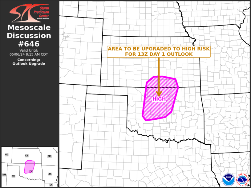
Posted: Mon May 06, 2024 8:40 am
by Texas Snowman
Could be another round of violent nighttime tornadoes…
Both the NAM and HRRR show a line in KS, but the NAM does show a few supercells.
But, high-risk seems iffy for even the OK region based on the models. Again, lots of squall lines. We have seen how off they can be though, so the SPC may see things that point more to supercells.
That said, the last high-risk for KS was 2017. So, people need to take it seriously.
Re: Texas Spring 2024
Posted: Mon May 06, 2024 10:14 am
by Cpv17
rwfromkansas wrote:Both the NAM and HRRR show a line in KS, but the NAM does show a few supercells.
But, high-risk seems iffy for even the OK region based on the models. Again, lots of squall lines. We have seen how off they can be though, so the SPC may see things that point more to supercells.
That said, the last high-risk for KS was 2017. So, people need to take it seriously.
I’ve noticed several times the mesoscale models miss out on supercells.
Sometimes they don't pick up on the embedded shortwave impulses (seen on 500mb/700mb height map) and in an environment like today, if something manages to go up then look out. Some of the parameters are definitely off the chart with insane hodographs depicted on various soundings across Oklahoma into Kansas, but you'll have better lift further north into Kansas as a result of that odd ejection of the trough/vort max cutting north. You may only get a few across northern/perhaps into central Oklahoma but better safe than sorry when you have signals in place like today.
Having said that, too much doom and gloom post all over social media right now. Definitely a day to listen to local trusted sources across that region.
Lots of low-level moisture in place so clouds/fog currently locked in, but unfortunately it appears that won't hang around long enough into the afternoon.
Re: Texas Spring 2024
Posted: Mon May 06, 2024 11:30 am
by ElectricStorm
Starting to get some clearing here in Norman. Gonna be a long day
Re: Texas Spring 2024
Posted: Mon May 06, 2024 12:23 pm
by cheezyWXguy
txtwister78 wrote:
Cpv17 wrote:
rwfromkansas wrote:Both the NAM and HRRR show a line in KS, but the NAM does show a few supercells.
But, high-risk seems iffy for even the OK region based on the models. Again, lots of squall lines. We have seen how off they can be though, so the SPC may see things that point more to supercells.
That said, the last high-risk for KS was 2017. So, people need to take it seriously.
I’ve noticed several times the mesoscale models miss out on supercells.
Sometimes they don't pick up on the embedded shortwave impulses (seen on 500mb/700mb height map) and in an environment like today, if something manages to go up then look out. Some of the parameters are definitely off the chart with insane hodographs depicted on various soundings across Oklahoma into Kansas, but you'll have better lift further north into Kansas as a result of that odd ejection of the trough/vort max cutting north. You may only get a few across northern/perhaps into central Oklahoma but better safe than sorry when you have signals in place like today.
Having said that, too much doom and gloom post all over social media right now. Definitely a day to listen to local trusted sources across that region.
Lots of low-level moisture in place so clouds/fog currently locked in, but unfortunately it appears that won't hang around long enough into the afternoon.
I’ve noticed that the hrrr tends to underdo supercell coverage, and the nam 3k constantly grows everything upscale immediately. I can’t remember the last time I saw it depict anything other than a line. Best to focus on the environmental parameters instead of the precip depiction in severe weather situations