Texas Fall-2016

U.S. & Caribbean Weather Discussions and Severe Weather Events

Moderator: S2k Moderators

Forum rules

The posts in this forum are NOT official forecast and should not be used as such. They are just the opinion of the poster and may or may not be backed by sound meteorological data. They are NOT endorsed by any professional institution or STORM2K.

Help Support Storm2K
Message
Author
Brent
S2K Supporter
S2K Supporter
Posts: 38087
Age: 36
Joined: Sun May 16, 2004 10:30 pm
Location: Tulsa Oklahoma
Contact:

Re: Texas Fall-2016

#101 Postby Brent » Wed Sep 14, 2016 10:16 pm

GFS again teasing a pattern change around day 10... I mean sooner or later, it has to verify, right? October is almost 384 hours out...

The 90s in the LR certainly do... :roll:

and again on the 0z... a big ole teaser...

Image
0 likes   
#neversummer

BrokenGlassRepublicn
Category 1
Category 1
Posts: 481
Joined: Sun Nov 20, 2011 8:07 pm
Location: Richardson, Texas

Re: Texas Fall-2016

#102 Postby BrokenGlassRepublicn » Thu Sep 15, 2016 11:23 am

gboudx wrote:Same thing happened to us in Rockwall. It was close enough to hear loud thunder and affect the DirecTV satellite signal. But, no drops.

I managed a victory in the spotty shower lottery. Picked up .26" in my rain gauge in Richardson.
0 likes   

User avatar
gboudx
S2K Supporter
S2K Supporter
Posts: 4080
Joined: Thu Sep 04, 2003 1:39 pm
Location: Rockwall, Tx but from Harvey, La

Re: Texas Fall-2016

#103 Postby gboudx » Thu Sep 15, 2016 12:59 pm

BrokenGlassRepublicn wrote:
gboudx wrote:Same thing happened to us in Rockwall. It was close enough to hear loud thunder and affect the DirecTV satellite signal. But, no drops.

I managed a victory in the spotty shower lottery. Picked up .26" in my rain gauge in Richardson.


Nice. I work at Cisco at Jupiter/Bush and there were puddles in the usual places in the parking lot indicating it rained here too.
0 likes   

weatherdude1108
Category 5
Category 5
Posts: 4228
Joined: Tue Dec 13, 2011 1:04 pm
Location: Northwest Austin/Cedar Park, TX

Re: Texas Fall-2016

#104 Postby weatherdude1108 » Thu Sep 15, 2016 3:26 pm

:wall: :37: :sleeping:

520
FXUS64 KEWX 152012
AFDEWX

Area Forecast Discussion
National Weather Service Austin/San Antonio TX
312 PM CDT THU SEP 15 2016

.SHORT TERM (Tonight through Friday Night)...
The coverage of showers this afternoon compared to yesterday is
considerably less. This is likely due to the strengthening mid-
level ridge axis across the northwestern Gulf of Mexico and
southern Texas.
While we do expect some showers and possibly a
thunderstorm this afternoon and early evening, chances will remain
at or below 20%. With the loss of daytime heating, any showers and
thunderstorms will decrease. On Friday, the mid-level ridge axis
remains intact while the mid and upper level low over the central
Gulf of Mexico gradually slides westward. For now, we will keep
rain chances fairly low and limited to areas east of Highway 83.
The highest rain chances will be confined to the coastal plains as
deeper moisture associated with the upper low drifts into the
Texas coast. The National Hurricane Center keeps chances for
development low (currently 20%) for the next several days. For
now, it appears any impacts from this system will likely remain
along the immediate coast.


&&

.LONG TERM (Saturday through Thursday)...
For the upcoming weekend, the forecast continues to trend drier as
the mid-level subtropical ridge axis remains the dominant weather
feature. In addition, the models continue to keep any frontal
boundaries well north of our region.
We will keep rain chances
in the forecast for all areas, except the Rio Grande plains. Rain
chances remain favored near the coastal plains as this area will
remain in proximity to deeper moisture. For early next week, the
mid-level subtropical ridge axis broadens across northern Mexico,
Texas and the lower Mississippi river valley. This pattern should
keep most areas dry for the early and middle portion of the
upcoming work week.
However, can`t completely rule out some
isolated showers and storms over the coastal plains and I-35
corridor during the afternoon and evening hours. We will keep rain
chances low to account for this possibility. Temperatures should
remain near climatological normals through the forecast period.
0 likes   
The preceding post is NOT an official forecast, and should not be used as such. It is only the opinion of the poster and may or may not be backed by sound meteorological data. It is NOT endorsed by any professional institution including storm2k.org. For Official Information please refer to the NHC and NWS products.

User avatar
Tireman4
S2K Supporter
S2K Supporter
Posts: 5853
Age: 59
Joined: Fri Jun 30, 2006 1:08 pm
Location: Humble, Texas
Contact:

Re: Texas Fall-2016

#105 Postby Tireman4 » Fri Sep 16, 2016 8:33 am

HGX says "No Soup For You" on a cool front in the distant future...


FXUS64 KHGX 160929
AFDHGX

Area Forecast Discussion
National Weather Service Houston/Galveston TX
429 AM CDT Fri Sep 16 2016

.DISCUSSION...
Precip coverage has been gradually increasing offshore in
association with a surface trof situated off the Tx coast. It will
continue its slow wwd progression and set up a convergent zone
along the coast today. This boundary should serve as a focus for
periods of shra/tstms throughout the day...esp as daytime heating
works its magic. There is a potential for some localized heavy
rainfall wherever stronger clusters set up near the sfc
trough/boundary considering that the overall steering flow is
fairly weak and available moisture will be well above normal (pw`s
2-2.3"). Majority of rain/storms should taper off by early evening
w/ the loss of heating - though there could be a couple lingering
cells around for the start of some of the high school football
games.

Coastal trof should wash out on Saturday...but there should still
be ample moisture for some scattered morning precip near the coast
that`ll spread inland during the daylight hours w/ heating.

Mid level ridge then starts building overhead on Sunday and
persists into the mid-late week time period. Look for rain
chances to start tapering off (but not completely shutdown) and
high temps to revert back to near August normals unfortunately. No
real good signals as to when our first decent fall front will
arrive. 47


&&

.MARINE...
Generally moderate east winds will prevail today with seas of 2 to 4
feet. However, the approach and passage of a trof/wave axis from the
NW Gulf into our marine areas is expected to produce widespread show-
ers and thunderstorms today and tonight. This unsettled weather will
help to increase winds/seas in and near the stronger storms. As this
system moves inland...winds should eventually veer to the SE through
the weekend. Looking ahead, light onshore winds and low seas will be
on tap for early next week. The slightly above normal tide levels of
late should also follow a gradual downward trend. 41

&&

.AVIATION...
Expecting a more active day today as deep Gulf moisture moves inland
in conjunction with a trof/wave axis. With low convective temps...we
will likely see widespread TSRAs starting around mid/late morning at
the coast...then spreading inland through the afternoon. Our current
TEMPO groups look to be on track. Otherwise VFR conditions to return
tonight as the activity dissipates. A repeat of this general pattern
is forecast for tomorrow as well. 41

&&

.PRELIMINARY POINT TEMPS/POPS...
College Station (CLL) 93 76 94 76 94 / 20 20 30 10 20
Houston (IAH) 91 76 91 76 93 / 50 20 50 20 30
Galveston (GLS) 89 80 88 81 90 / 50 50 50 30 30

&&

.HGX WATCHES/WARNINGS/ADVISORIES...
TX...NONE.
GM...NONE.

&&

$$
0 likes   

User avatar
Ntxw
Storm2k Moderator
Storm2k Moderator
Posts: 22783
Joined: Wed Oct 21, 2009 6:34 pm
Location: DFW, Texas

Re: Texas Fall-2016

#106 Postby Ntxw » Fri Sep 16, 2016 9:51 am

Through the first half of September DFW is running 2.2F above normal and below normal rainfall. While not the near 100 readings of the past few Septembers, its been consistently warm and continues the string of above normal Septembers the last below normal being in 2009
0 likes   
The above post and any post by Ntxw is NOT an official forecast and should not be used as such. It is just the opinion of the poster and may or may not be backed by sound meteorological data. It is NOT endorsed by any professional institution including Storm2k. For official information, please refer to NWS products.

  Help support Storm2K!
Help Support Storm2K

User avatar
Tireman4
S2K Supporter
S2K Supporter
Posts: 5853
Age: 59
Joined: Fri Jun 30, 2006 1:08 pm
Location: Humble, Texas
Contact:

Re: Texas Fall-2016

#107 Postby Tireman4 » Fri Sep 16, 2016 11:45 am

Ok NTXW....look into your crystal ball....Early October for our first drying front?
0 likes   

User avatar
Ntxw
Storm2k Moderator
Storm2k Moderator
Posts: 22783
Joined: Wed Oct 21, 2009 6:34 pm
Location: DFW, Texas

Re: Texas Fall-2016

#108 Postby Ntxw » Fri Sep 16, 2016 2:35 pm

Tireman4 wrote:Ok NTXW....look into your crystal ball....Early October for our first drying front?


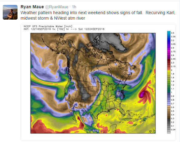
Crystal ball is foggy right now :(. Mid month change of air masses didn't really pan out and there are not analogs that really stick out. Uncharted territory, the best is to go with what is (dry and mild) until there is something definitive within 5-7 days. medium to long range forecasting seems (at least in my point of view) a struggling task right now and will continue.
0 likes   
The above post and any post by Ntxw is NOT an official forecast and should not be used as such. It is just the opinion of the poster and may or may not be backed by sound meteorological data. It is NOT endorsed by any professional institution including Storm2k. For official information, please refer to NWS products.


  Help support Storm2K!

Help Support Storm2K


User avatar
Tireman4
S2K Supporter
S2K Supporter
Posts: 5853
Age: 59
Joined: Fri Jun 30, 2006 1:08 pm
Location: Humble, Texas
Contact:

Re: Texas Fall-2016

#109 Postby Tireman4 » Fri Sep 16, 2016 2:55 pm

Drat. Just dadgum drat. :uarrow:
0 likes   

User avatar
Ntxw
Storm2k Moderator
Storm2k Moderator
Posts: 22783
Joined: Wed Oct 21, 2009 6:34 pm
Location: DFW, Texas

Re: Texas Fall-2016

#110 Postby Ntxw » Fri Sep 16, 2016 3:08 pm

That doesn't mean there is nothing to talk about! The Arctic is slowly going into slumber. I think this year was the second highest melt (second lowest min) in the records somewhere near 2007. But lately it's come to a halt and rapid refreeze has taken over to give it the earliest minimum on record being the first week of Sept (usually it is second and even third week) due to lower heights and cyclones over the Arctic circle. So while it is yet to be cool here, the northern hemisphere is getting colder :D.
1 likes   
The above post and any post by Ntxw is NOT an official forecast and should not be used as such. It is just the opinion of the poster and may or may not be backed by sound meteorological data. It is NOT endorsed by any professional institution including Storm2k. For official information, please refer to NWS products.


  Help support Storm2K!

Help Support Storm2K


User avatar
Tireman4
S2K Supporter
S2K Supporter
Posts: 5853
Age: 59
Joined: Fri Jun 30, 2006 1:08 pm
Location: Humble, Texas
Contact:

Re: Texas Fall-2016

#111 Postby Tireman4 » Fri Sep 16, 2016 3:12 pm

Well, I will take all I can get young sir.
0 likes   

aggiecutter
Category 5
Category 5
Posts: 1753
Joined: Thu Oct 14, 2004 9:22 pm
Location: Texarkana

Re: Texas Fall-2016

#112 Postby aggiecutter » Fri Sep 16, 2016 4:16 pm

Ntxw wrote:
Tireman4 wrote:Ok NTXW....look into your crystal ball....Early October for our first drying front?


Crystal ball is foggy right now :(. Mid month change of air masses didn't really pan out and there are not analogs that really stick out. Uncharted territory, the best is to go with what is (dry and mild) until there is something definitive within 5-7 days. medium to long range forecasting seems (at least in my point of view) a struggling task right now and will continue.


Image
0 likes   

Brent
S2K Supporter
S2K Supporter
Posts: 38087
Age: 36
Joined: Sun May 16, 2004 10:30 pm
Location: Tulsa Oklahoma
Contact:

Re: Texas Fall-2016

#113 Postby Brent » Fri Sep 16, 2016 7:11 pm

I never thought we'd see a headline of near 100s possible this deep into September :roll: .... I guess we're paying for mid to late august being so nice... gfs still has signs of a more sizable front around the 25th and climo strongly favors first 50s at dfw around then.... hopefully...
0 likes   
#neversummer

gpsnowman
S2K Supporter
S2K Supporter
Posts: 3185
Joined: Fri Jan 07, 2011 10:35 am
Location: Grand Prairie Tx

Re: Texas Fall-2016

#114 Postby gpsnowman » Sat Sep 17, 2016 8:20 am

Man, summer will be back "screaming for vengeance", to borrow a song from Judas Priest. Boo hiss. A lot of heat and humidity for the next week at least. :grr: :grr:
0 likes   

BrokenGlassRepublicn
Category 1
Category 1
Posts: 481
Joined: Sun Nov 20, 2011 8:07 pm
Location: Richardson, Texas

Re: Texas Fall-2016

#115 Postby BrokenGlassRepublicn » Sat Sep 17, 2016 8:24 am

Tireman4 wrote:Drat. Just dadgum drat. :uarrow:

I will take what we have. 105+ temps in September are nothing short of soul-crushing.
0 likes   

Brent
S2K Supporter
S2K Supporter
Posts: 38087
Age: 36
Joined: Sun May 16, 2004 10:30 pm
Location: Tulsa Oklahoma
Contact:

Re: Texas Fall-2016

#116 Postby Brent » Sat Sep 17, 2016 11:31 am

The Euro is aboard the idea of a significant front and rain chances starting next weekend into the 26th-27th timeframe... maybe this will be the last stretch of hot and dry.

Change is coming... maybe:

Image
0 likes   
#neversummer

User avatar
JDawg512
Category 5
Category 5
Posts: 1075
Age: 45
Joined: Mon Aug 26, 2013 8:56 pm
Location: Austin
Contact:

Re: Texas Fall-2016

#117 Postby JDawg512 » Sat Sep 17, 2016 10:49 pm

:cry:

7 days ago, the forecasts had this weekend being wet and a continued unsettled pattern going into next week. Just goes to show that there's a lot more to take into consideration than model data. As others have already mentioned, it's getting to the point where any long range forecast is basically useless.

One thing thats worth mentioning is over the last 3 to 4 days, there has been an ongoing mass migration of butterflies going through Austin. General direction is from the northwest to the southeast. Hopefully it's an indicator of an overall shift to cooler conditions on the horizon. Maybe a 2 week time frame given that these types of migrations tend to, (but not always) occur roughly 2 weeks ahead of a significant change in the weather. It depends on the species though as some start migration at a specific time regardless of weather patterns.
0 likes   
Resident Rain Miser

I am a weather hobbyist living 3.5 miles south of Downtown Austin and in no way or fashion should anything I say concerning forecasts be taken seriously. Please check your local NWS for accurate weather forecasting and conditions.

Brent
S2K Supporter
S2K Supporter
Posts: 38087
Age: 36
Joined: Sun May 16, 2004 10:30 pm
Location: Tulsa Oklahoma
Contact:

Re: Texas Fall-2016

#118 Postby Brent » Sun Sep 18, 2016 12:32 am

JDawg512 wrote::cry:

7 days ago, the forecasts had this weekend being wet and a continued unsettled pattern going into next week. Just goes to show that there's a lot more to take into consideration than model data. As others have already mentioned, it's getting to the point where any long range forecast is basically useless.


I know, and that weighs on my mind everytime I look out in that range(even lamented about it at work), but climo strongly favors the last week of September for at least some 50s around DFW, so it has to happen soon.

I found it interesting as hot as 2011 was, that DFW hit the 50s on September 6th! Much earlier than usual. In fact, it was the earliest 50s I found at DFW in September since 1990. Almost as surprisingly, the latest I found was October 16th in 2007 of all years.
0 likes   
#neversummer

gpsnowman
S2K Supporter
S2K Supporter
Posts: 3185
Joined: Fri Jan 07, 2011 10:35 am
Location: Grand Prairie Tx

Re: Texas Fall-2016

#119 Postby gpsnowman » Sun Sep 18, 2016 5:58 am

Heads up Denton and Collin counties, you might be hearing some rain and thunder soon.
0 likes   

User avatar
Portastorm
Storm2k Moderator
Storm2k Moderator
Posts: 9914
Age: 63
Joined: Fri Jul 11, 2003 9:16 am
Location: Round Rock, TX
Contact:

Re: Texas Fall-2016

#120 Postby Portastorm » Sun Sep 18, 2016 9:32 am

GFS and King Euro continue honking about that first real cold front for Texas. Fingers crossed.

Image

Image
0 likes   
Any forecasts under my name are to be taken with a grain of salt. Get your best forecasts from the National Weather Service and National Hurricane Center.


Return to “USA & Caribbean Weather”

Who is online

Users browsing this forum: Brent and 11 guests