Severe Weather Threat 4-15-03

U.S. & Caribbean Weather Discussions and Severe Weather Events

Moderator: S2k Moderators

Forum rules

The posts in this forum are NOT official forecast and should not be used as such. They are just the opinion of the poster and may or may not be backed by sound meteorological data. They are NOT endorsed by any professional institution or STORM2K.

Help Support Storm2K
Message
Author
User avatar
wx247
S2K Supporter
S2K Supporter
Posts: 14279
Age: 41
Joined: Wed Feb 05, 2003 10:35 pm
Location: Monett, Missouri
Contact:

Severe Weather Threat 4-15-03

#1 Postby wx247 » Tue Apr 15, 2003 7:49 am

Image

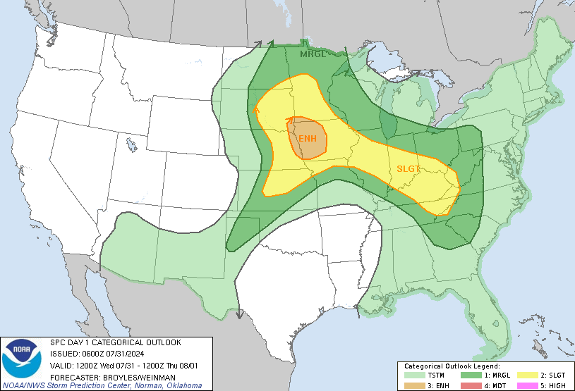
Here are the severe weather threat areas for today...April 15, 2003!

A potential damaging wind event is possible this afternoon/tonight...
0 likes   
Personal Forecast Disclaimer:
The posts in this forum are NOT official forecast and should not be used as such. They are just the opinion of the poster and may or may not be backed by sound meteorological data. They are NOT endorsed by any professional institution or storm2k.org. For official information, please refer to the NHC and NWS products.

pojo
Military Member
Military Member
Posts: 8016
Age: 43
Joined: Thu Feb 06, 2003 9:16 pm
Location: Houston

#2 Postby pojo » Tue Apr 15, 2003 11:36 am

I'm in the Slight Territory! Oh yea!!! :D :D
0 likes   

User avatar
wx247
S2K Supporter
S2K Supporter
Posts: 14279
Age: 41
Joined: Wed Feb 05, 2003 10:35 pm
Location: Monett, Missouri
Contact:

#3 Postby wx247 » Tue Apr 15, 2003 1:47 pm

LOL. :) First time this year Shannon?
0 likes   
Personal Forecast Disclaimer:
The posts in this forum are NOT official forecast and should not be used as such. They are just the opinion of the poster and may or may not be backed by sound meteorological data. They are NOT endorsed by any professional institution or storm2k.org. For official information, please refer to the NHC and NWS products.

pojo
Military Member
Military Member
Posts: 8016
Age: 43
Joined: Thu Feb 06, 2003 9:16 pm
Location: Houston

#4 Postby pojo » Tue Apr 15, 2003 2:44 pm

no, I always get excited when severe weather season approaches :D
0 likes   

ColdFront77

#5 Postby ColdFront77 » Tue Apr 15, 2003 3:52 pm

It's about time some more potentially severe weather is coming. We have been in a lull the past few days.
Last edited by ColdFront77 on Tue Apr 15, 2003 8:24 pm, edited 2 times in total.
0 likes   

User avatar
wx247
S2K Supporter
S2K Supporter
Posts: 14279
Age: 41
Joined: Wed Feb 05, 2003 10:35 pm
Location: Monett, Missouri
Contact:

#6 Postby wx247 » Tue Apr 15, 2003 3:57 pm

I agree Tom. It has been a few days since we have had some storms.
0 likes   
Personal Forecast Disclaimer:
The posts in this forum are NOT official forecast and should not be used as such. They are just the opinion of the poster and may or may not be backed by sound meteorological data. They are NOT endorsed by any professional institution or storm2k.org. For official information, please refer to the NHC and NWS products.

User avatar
wx247
S2K Supporter
S2K Supporter
Posts: 14279
Age: 41
Joined: Wed Feb 05, 2003 10:35 pm
Location: Monett, Missouri
Contact:

#7 Postby wx247 » Tue Apr 15, 2003 4:13 pm

Image

MESOSCALE DISCUSSION 0462
NWS STORM PREDICTION CENTER NORMAN OK
0358 PM CDT TUE APR 15 2003

AREAS AFFECTED...AR SD...SRN MN

CONCERNING...SEVERE THUNDERSTORM POTENTIAL

VALID 152058Z - 152330Z

THUNDERSTORMS ARE EXPECTED TO DEVELOP BY EARLY EVENING. LARGE
HAIL AND DAMAGING WINDS WILL BE LIKELY. AREA WILL BE MONITORED
FOR POSSIBLE WW DURING THE NEXT 1-2 HOURS.

LATEST OBJECTIVE ANALYSIS SHOWS WEAKENING CAP OVER SERN SD INTO
SRN MN...WITH LESS THAN 150 J/KG OF 100 MB MLCIN. STORMS ARE
EXPECTED TO DEVELOP ALONG WARM FRONT WHERE AN INCREASING LOW
LEVEL JET WILL HELP LIFT INCREASING MOISTURE. 18Z RUC DEVELOPS
PRECIPITATION IN THESE AREAS NEAR 00Z...FROM SERN SD INTO SRN MN.
MDT INSTABILITY...STEEP LAPSE RATES AND PERSISTENT FORCING WILL
FAVOR SEVERE THUNDERSTORMS WITH LARGE HAIL AND DAMAGING WINDS.
0 likes   
Personal Forecast Disclaimer:
The posts in this forum are NOT official forecast and should not be used as such. They are just the opinion of the poster and may or may not be backed by sound meteorological data. They are NOT endorsed by any professional institution or storm2k.org. For official information, please refer to the NHC and NWS products.


Return to “USA & Caribbean Weather”

Who is online

Users browsing this forum: No registered users and 12 guests