
Texas Spring 2026
Moderator: S2k Moderators
Forum rules

The posts in this forum are NOT official forecast and should not be used as such. They are just the opinion of the poster and may or may not be backed by sound meteorological data. They are NOT endorsed by any professional institution or STORM2K.
-
wxman22

- Category 5

- Posts: 2051
- Joined: Mon Jan 30, 2006 12:39 am
- Location: Wichita Falls, TX
- Contact:
Re: Texas Spring 2026
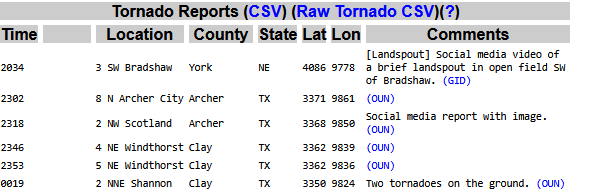
That supercell has produced a confirmed large tornado in Archer and Clay county. So much for my prediction the other day that the severe weather would stay east of NW Texas this weekend...
0 likes
-
WeatherNewbie
- Tropical Storm

- Posts: 237
- Joined: Mon Mar 22, 2010 3:42 pm
- Location: Richardson, Texas
Re: Texas Spring 2026
TX4Cats wrote:I've had several rumbles of thunder in The Colony. Can't remember ever hearing that from a storm so far away.
I'm hearing it all the way down at the border of Dallas and Richardson.
0 likes
The above post is NOT an official forecast and should not be used as such. It is just the opinion of the poster and may or may not be backed by sound meteorological data. It is NOT endorsed by any professional institution including storm2k.org. For official information, please refer to NWS products.
-
rwfromkansas
- Category 5
- Posts: 3065
- Joined: Sat Aug 27, 2005 12:47 am
- Location: North Fort Worth
Re: Texas Spring 2026
Well, this storm is making up for the lack of severe. I often say the severe here isn't like the storms I had growing up in Kansas, but this is INTENSE. This is insane. The thunder and lightning well in advance is crazy, as well as the very long stretchy storm structure.
I hope the hail drops down before it hits me in north Tarrant!! It seems to be slowing down, so that's good...
On another note, I hope they fix this site. It is almost unusable.
I hope the hail drops down before it hits me in north Tarrant!! It seems to be slowing down, so that's good...
On another note, I hope they fix this site. It is almost unusable.
3 likes
-
wxman22
- Category 5
- Posts: 2051
- Joined: Mon Jan 30, 2006 12:39 am
- Location: Wichita Falls, TX
- Contact:
Re: Texas Spring 2026
Wow a long track supercell for sure now.Be safe in DFW. That storm was crazy when it was up here earlier. And produced twin tornadoes!
Twin tornadoes
https://www.facebook.com/share/p/1GsKV53j18/
Archer County Tornado


Twin tornadoes
https://www.facebook.com/share/p/1GsKV53j18/
Archer County Tornado
Last edited by wxman22 on Sun Apr 26, 2026 11:27 am, edited 1 time in total.
1 likes
-
wxman22
- Category 5
- Posts: 2051
- Joined: Mon Jan 30, 2006 12:39 am
- Location: Wichita Falls, TX
- Contact:
Re: Texas Spring 2026
Yesterday was something else.The tornado in Archer county was caught live on air on the local news yesterday.Unfortunately two people lost their lives in the storm.Incredible damage,wouldn't be surprised to see an EF3 rating at least.
https://www.facebook.com/share/v/1G63A6ZGue/


https://www.facebook.com/share/v/1G63A6ZGue/
Last edited by wxman22 on Sun Apr 26, 2026 10:20 am, edited 2 times in total.
0 likes
-
wxman22
- Category 5
- Posts: 2051
- Joined: Mon Jan 30, 2006 12:39 am
- Location: Wichita Falls, TX
- Contact:
Re: Texas Spring 2026
For today.

Last edited by wxman22 on Sun Apr 26, 2026 12:14 pm, edited 1 time in total.
0 likes
-
txtwister78

- Category 5
- Posts: 2255
- Joined: Wed Jan 30, 2019 12:56 pm
- Location: San Antonio
Re: Texas Spring 2026
Sad to see any loss of life regardless of what causes it when weather is involved, but fortunately that storm was the meanest looking over more rural areas when it really got its act together on radar or this could have been much worse as it moved into more populated areas
Lots of hail which is normal with these long tracked supercells from Wichita (as literally highlighted above in several post) with other hail reports all the way into the DFW metro.
The other factor that often gets overlooked but is even more dangerous to a much larger area is the torrential rainfall/flood risk these things can put down in a short period of time. Naturally being at night, that makes it worse.
0 likes
-
cheezyWXguy

- Category 5
- Posts: 6283
- Joined: Mon Feb 13, 2006 12:29 am
- Location: Dallas, TX
Re: Texas Spring 2026
Not to derail, but has anyone else had trouble accessing the site lately? I couldn’t get in at all yesterday
1 likes
-
Stratton23
- Category 5
- Posts: 3588
- Joined: Fri Jul 21, 2023 10:59 pm
- Location: Katy, Tx
Re: Texas Spring 2026
next weekend looks more like a multiday heavy rain event type setup compared to severe weather
0 likes

Re: Texas Spring 2026
cheezyWXguy wrote:Not to derail, but has anyone else had trouble accessing the site lately? I couldn’t get in at all yesterday
Came to ask the same. I tried to get on for like 5 straight hours last night and kept getting a 501 internal error.
0 likes
-
rwfromkansas
- Category 5
- Posts: 3065
- Joined: Sat Aug 27, 2005 12:47 am
- Location: North Fort Worth
Re: Texas Spring 2026
Had issues for a week or so with the site.
I ended with 3 inches. Very impressive for effectively one supercell (did spin-off another). That was one of the craziest storms of my life to watch. I’ve had worse IMBY but it was nuts. Luckily I was on the northeast end away from the worst hail. Folks just a bit west got hammered.
I ended with 3 inches. Very impressive for effectively one supercell (did spin-off another). That was one of the craziest storms of my life to watch. I’ve had worse IMBY but it was nuts. Luckily I was on the northeast end away from the worst hail. Folks just a bit west got hammered.
0 likes

Re: Texas Spring 2026
rwfromkansas wrote:Had issues for a week or so with the site.
I ended with 3 inches. Very impressive for effectively one supercell (did spin-off another). That was one of the craziest storms of my life to watch. I’ve had worse IMBY but it was nuts. Luckily I was on the northeast end away from the worst hail. Folks just a bit west got hammered.
Same here. Frustrating not being able to chime in.
I've never seen so much thunder and lightning before a rain drop falls. It was intense. The lightning was so close and the thunder was so loud where I was in Coppell, with the main storms hours away. Didn't think something like that was possible. Just incredible. The house in GP got hit hard. Wife said all forms of severe happened. Luckily the hail wasn't only pea size. I had to stay north for work but man what an amazing experience.
0 likes
-
wxman22
- Category 5
- Posts: 2051
- Joined: Mon Jan 30, 2006 12:39 am
- Location: Wichita Falls, TX
- Contact:
Re: Texas Spring 2026
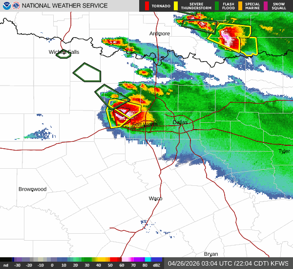
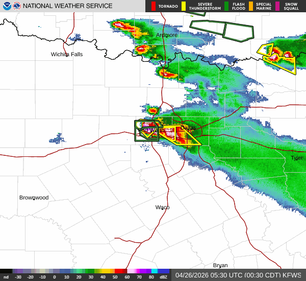
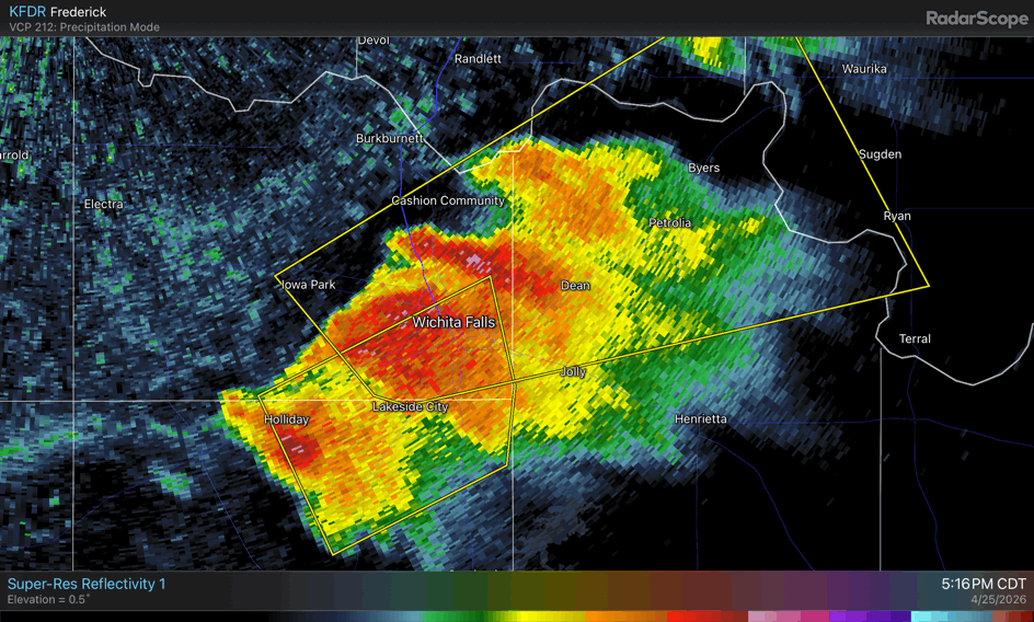
We had over 40 mins of quarter to ping pong size hail and flooding rains.The water got to my doorstep. The storm formed from three supercells that were over the Wichita Falls area. These cells merged into one potent textbook supercell that became tornadic as it moved off the dryline and towards the southeast.The supercell produced multiple tornadoes and numerous reports of large hail from Wichita Falls to DFW. There were also reports of hurricane force wind gust in some spots.(supercell merger below)
One thing I have noticed so far this season is that the cap has not been as much of an issue as some had feared it would be due to the drought.For most of the conditional days so far this year the cap has broken somewhere in the southern plains.
One thing I have noticed so far this season is that the cap has not been as much of an issue as some had feared it would be due to the drought.For most of the conditional days so far this year the cap has broken somewhere in the southern plains.
0 likes
-
txtwister78
- Category 5
- Posts: 2255
- Joined: Wed Jan 30, 2019 12:56 pm
- Location: San Antonio
Re: Texas Spring 2026
wxman22 wrote:We had over 40 mins of quarter to ping pong size hail and flooding rains.The water got to my doorstep. The storm formed from three supercells that were over the Wichita Falls area. These cells merged into one potent textbook supercell that became tornadic as it moved off the dryline and towards the southeast.The supercell produced multiple tornadoes and numerous reports of large hail from Wichita Falls to DFW. There were also reports of hurricane force wind gust in some spots.(supercell merger below)
One thing I have noticed so far this season is that the cap has not been as much of an issue as some had feared it would be due to the drought.For most of the conditional days so far this year the cap has broken somewhere in the southern plains.
https://i.postimg.cc/P51Lf7Zf/animated.gif
The cap breaking further north isn't unusual given that region has had better lift to work with either from ejecting disturbances from the SW/frontal boundaries or leftover boundaries interacting with the dryline from previous day storms.
Across N TX outside of last evening the cap has held however but overall it's been the Oklahoma points N/NE regions when it comes to severe weather but as I mentioned given the setup not that surprising.
Next wk could be more active again further south into Texas as a front charges in.
0 likes
-
wxman22
- Category 5
- Posts: 2051
- Joined: Mon Jan 30, 2006 12:39 am
- Location: Wichita Falls, TX
- Contact:
Re: Texas Spring 2026
txtwister78 wrote:wxman22 wrote:We had over 40 mins of quarter to ping pong size hail and flooding rains.The water got to my doorstep. The storm formed from three supercells that were over the Wichita Falls area. These cells merged into one potent textbook supercell that became tornadic as it moved off the dryline and towards the southeast.The supercell produced multiple tornadoes and numerous reports of large hail from Wichita Falls to DFW. There were also reports of hurricane force wind gust in some spots.(supercell merger below)
One thing I have noticed so far this season is that the cap has not been as much of an issue as some had feared it would be due to the drought.For most of the conditional days so far this year the cap has broken somewhere in the southern plains.
https://i.postimg.cc/P51Lf7Zf/animated.gif
The cap breaking further north isn't unusual given that region has had better lift to work with either from ejecting disturbances from the SW/frontal boundaries or leftover boundaries interacting with the dryline from previous day storms.
Across N TX outside of last evening the cap has held however but overall it's been the Oklahoma points N/NE regions when it comes to severe weather but as I mentioned given the setup not that surprising.
Next wk could be more active again further south into Texas as a front charges in.
Nah, not just yesterday.Theirs been several conditional days this month that the cap has broken along the dryline in NW Texas specifically. I'm not just referring to the current severe weather sequence. I would know I've been keeping count and i live up here. April reports below. Not all of those reports in Texas come from conditional days but many do.

0 likes
-
mmmmsnouts
- Tropical Storm
- Posts: 219
- Joined: Tue Sep 05, 2023 10:04 pm
- Location: Arlington, TX
-
wxman22
- Category 5
- Posts: 2051
- Joined: Mon Jan 30, 2006 12:39 am
- Location: Wichita Falls, TX
- Contact:
Re: Texas Spring 2026

Mesoscale Discussion 0550
NWS Storm Prediction Center Norman OK
0325 PM CDT Sun Apr 26 2026
Areas affected...Portions of southwestern Oklahoma and western north
Texas
Concerning...Severe potential...Watch possible
Valid 262025Z - 262230Z
Probability of Watch Issuance...40 percent
SUMMARY...The potential for rapid severe thunderstorm development is
being monitored across western north TX and southwestern OK.
DISCUSSION...The latest surface observations show a trough/dryline
extending southwestward from near Lawton, OK to Haskell, TX. A
narrow, though deepening, cumulus field is apparent in visible
satellite imagery along this boundary. Very warm and moist surface
conditions are present ahead of this dryline, with temperatures in
the low 90s and dewpoints in the low 70s yielding extreme
instability ~4000 J/kg MLCAPE. Although mid to upper-level ascent is
currently lacking, continued enhanced surface convergence along the
dryline, increasing westerly flow aloft through this evening, and a
colder pocket of mid to upper-level air may aid in convective
initiation before 6 PM as peak heating is reached.
In addition to the highly buoyant airmass in place, 50-55 kt of
orthogonal effective bulk shear will support discrete supercells and
a threat of very large hail and perhaps a tornado, especially if any
thunderstorm can remain near the convergence axis through this
evening as the LLJ intensifies (200-300 m2/s2 SRH). Conditions will
continued to be monitored for convective initiation, and a watch may
be needed if this occurs.
0 likes
-
wxman22
- Category 5
- Posts: 2051
- Joined: Mon Jan 30, 2006 12:39 am
- Location: Wichita Falls, TX
- Contact:
Re: Texas Spring 2026
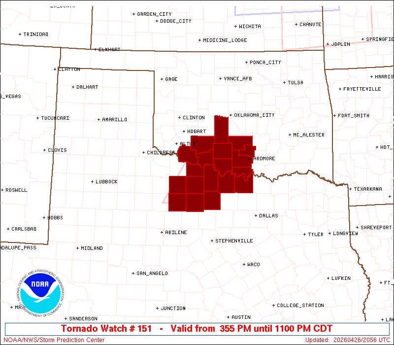
URGENT - IMMEDIATE BROADCAST REQUESTED
Tornado Watch Number 151
NWS Storm Prediction Center Norman OK
355 PM CDT Sun Apr 26 2026
The NWS Storm Prediction Center has issued a
* Tornado Watch for portions of
Southern Oklahoma
Western North Texas
* Effective this Sunday afternoon and evening from 355 PM until
1100 PM CDT.
* Primary threats include...
A couple tornadoes possible
Scattered large hail likely with isolated very large hail events
to 3 inches in diameter possible
Scattered damaging wind gusts to 70 mph possible
SUMMARY...Initial storm development appears imminent near the Red
River, and a very unstable environment and stronger deep-layer winds
will support intense supercells capable of very large hail. Tornado
potential would also steadily increase into this evening.
The tornado watch area is approximately along and 45 statute miles
east and west of a line from 40 miles east northeast of Fort Sill OK
to 60 miles south southwest of Wichita Falls TX. For a complete
depiction of the watch see the associated watch outline update
(WOUS64 KWNS WOU1).
0 likes
-
txtwister78
- Category 5
- Posts: 2255
- Joined: Wed Jan 30, 2019 12:56 pm
- Location: San Antonio
Re: Texas Spring 2026
wxman22 wrote:txtwister78 wrote:wxman22 wrote:We had over 40 mins of quarter to ping pong size hail and flooding rains.The water got to my doorstep. The storm formed from three supercells that were over the Wichita Falls area. These cells merged into one potent textbook supercell that became tornadic as it moved off the dryline and towards the southeast.The supercell produced multiple tornadoes and numerous reports of large hail from Wichita Falls to DFW. There were also reports of hurricane force wind gust in some spots.(supercell merger below)
One thing I have noticed so far this season is that the cap has not been as much of an issue as some had feared it would be due to the drought.For most of the conditional days so far this year the cap has broken somewhere in the southern plains.
https://i.postimg.cc/P51Lf7Zf/animated.gif
The cap breaking further north isn't unusual given that region has had better lift to work with either from ejecting disturbances from the SW/frontal boundaries or leftover boundaries interacting with the dryline from previous day storms.
Across N TX outside of last evening the cap has held however but overall it's been the Oklahoma points N/NE regions when it comes to severe weather but as I mentioned given the setup not that surprising.
Next wk could be more active again further south into Texas as a front charges in.
Nah, not just yesterday.Theirs been several conditional days this month that the cap has broken along the dryline in NW Texas specifically. I'm not just referring to the current severe weather sequence. I would know I've been keeping count and i live up here. April reports below. Not all of those reports in Texas come from conditional days but many do.
https://www.spc.noaa.gov/climo/summary/2026/ruf/NAT/NAT_APR_ALL.png
Actually yeah and trust me brother I know you keep track as documented by your multiple play by play post up there. I get where you live etc (you highlighted it above just in case we missed it) so no worries but that doesn't change the discussion or facts that I outlined respectfully either in my response.
Just an FYI you can have caps in place daily in the spring/summer (not unusual for the south) but the ability for storms to fire and thus breach that cap is highly dependent on factors like lifting mechanisms as I described above so again I stand by my statement in that further north that really hasn't been much of a surprise or high hurdle to meet thus far this season in that there has been more lift available up there to work with. So again I don't think that's been up for much debate as you indicated.
When I said "N TX" I was talking DFW generally speaking. It wasn't meant as a slight to Wichita or "NW TX" which I didn't mention. I don't view severe weather as a contest of who gets more or less trust me my friend in that regar but your graphic proves my point.
0 likes
Return to “USA & Caribbean Weather”
Who is online
Users browsing this forum: Cpv17, txtwister78, wxman22 and 36 guests