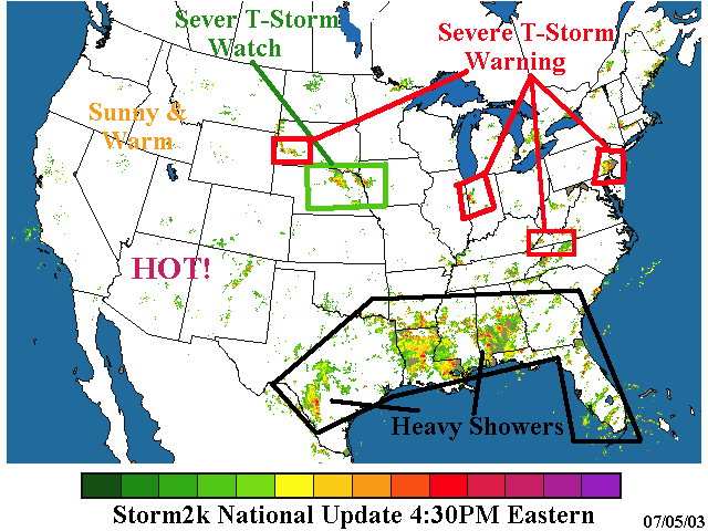
Storm2k National Update 4:30PM Eastern
Moderator: S2k Moderators
Forum rules

The posts in this forum are NOT official forecast and should not be used as such. They are just the opinion of the poster and may or may not be backed by sound meteorological data. They are NOT endorsed by any professional institution or STORM2K.
-
chadtm80
Storm2k National Update 4:30PM Eastern
Last edited by chadtm80 on Sat Jul 05, 2003 3:55 pm, edited 3 times in total.
0 likes
-
Guest
Well as soon as this thread was posted - I get a severe thunderstorm - thundering and rain and more rain and more rain again. I agree with the flood watch. Just which way is all that rain in the Hill Country moving? East - if it is - I'm going out there and building my ark....
I think this is trying to make up for our 10 inch deficit. And David(Vbhoutex) left town.
Patricia
I think this is trying to make up for our 10 inch deficit. And David(Vbhoutex) left town.
Patricia
0 likes
-
chadtm80
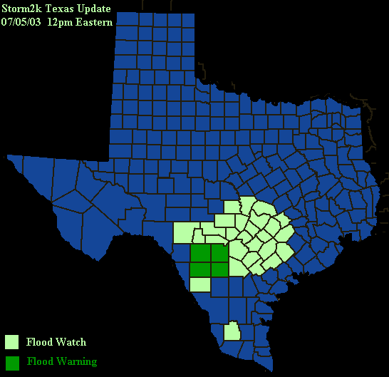
Map Updated above @ 11am eastern!
..Flash Flood Watch Continues For Parts Of South Central Texas And The Texas Hill Country Until 600 Pm Saturday...
..a Flash Flood Warning remains in effect for Medina and Uvalde counties until 1015 am.
The Flash Flood Watch includes the following counties... Atascosa... Bandera... Bastrop... Bexar... blanco... Burnet... Caldwell... Comal... DeWitt... Dimmit... Edwards... Fayette... frio... Gillespie... Gonzales... Guadalupe... Hays... Karnes... Kendall... Kerr... Lavaca... lee. ..Llano... Medina... real... Travis... Uvalde... Williamson... Wilson and Zavala.
A persistent upper level storm system located over the Mexican plateau will continue to feed abundant moisture and instability into south central Texas. As the system remains nearly stationary... it will continue sending upper air disturbances into the area through Sunday morning. The resulting heavy rains will continue to be a threat to areas prone flash flooding and low lying flooding of rivers and streams.
The main focus of heavy rain will extend from along the Interstate 35 corridor including the Austin and San Antonio metropolitan areas to the western Hill Country and Rio Grande. Rainfall amounts of one to three inches with isolated three to six inch totals can be expected today in the watch area.
At 940 am... National Weather Service Doppler indicated heavy rains covering a large portion of the area... extending from southern Uvalde County through Medina... Bexar... Bandera and Kendall counties. Rainfall rates of three quarters of an inch to one and one half inches per hour will continue for the next couple hours. San Antonio International Airport reported 2.11 inches of rain over the past four hours as well as Hondo Municipal Airport running at nearly 4 inches.
A Flash Flood Watch means that the flooding of streams... creeks... and low lying areas is possible within the watch area. Motorists should remain alert for heavy rains and avoid driving through low lying areas or into high water. Do not drive around barricades.
The National Weather Service in Austin San Antonio has issued a
* Flash Flood Warning for the following counties... Medina Uvalde
* until 1015 am CDT
* at 725 am... weather service Doppler radar indicated very heavy rain across much of Medina and eastern Uvalde County. Rainfall rates of 1 to 2 inches per hour will persist for the next couple of hours. Hondo airport has reported 2.12 inches of rain as of 7 am. The additional rainfall will cause streams to continue to rise. Persons along Hondo and Seco creeks should be especially cautious.
Excessive runoff from this storm will cause flash flooding of small creeks and streams... highways and underpasses. Additionally... country roads and Farmlands along the banks of creeks and streams and other low lying areas are subject to flash flooding.
Do not drive your vehicle into areas where the water covers the roadway. The water depth may be too great to allow your car to cross safely. Vehicles caught in rising water should be abandoned quickly. Move to higher ground.
Lat... Lon 2912 9978 2912 9886 2956 9882 2962 9979
...Fire Weather Watch Remains In Effect For Saturday Afternoon In West Lolo...Salish And Kootenai Reservation...East Lolo...
bitterroot-deerlodge/west Beaverhead... east Beaverhead (zones 106 through 111) for increasing winds and low relative humidities...
******************************************************************** winds have diminished and humidities are beginning to recover this evening in the deerlodge and Beaverhead National forecast. Therefore the red flag warning has ended.
Fire Weather Watch for tomorrow... we will see a brief air mass change Saturday as a system moves down from British Columbia. This will increase winds across the district... but most notably in the Montana zones. Humidities will improve some over extreme northwest Montana where we could even see some shower and thunderstorm activity. However... west central and southwest Montana will be slower to react to the increasing moisture. A Fire Weather Watch remains in effect for those areas Saturday afternoon
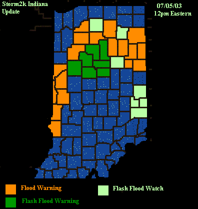
The National Weather Service in northern Indiana has issued a
* Flash Flood Warning for... Adams County in Indiana Blackford County in Indiana Grant County in Indiana Huntington County in Indiana Jay County in Indiana Wabash County in Indiana Wells County in Indiana
* until 1100 am EST
* at 803 am EST... National Weather Service Doppler radar indicated thunderstorms with very heavy rain over Cass and Miami counties moving east at 25 mph. Rainfall over the warned counties overnight has ranged from 2 to 5 inches with local amounts over 7 inches. Addition rainfall of 1 to 2 inches over the next 3 hours will cause flash flooding due to the already saturated ground.
Do not drive your vehicle into areas where the water covers the roadway.
To report severe weather have the nearest law enforcement agency relay your report to the National Weather Service forecast office in northern Indiana.
Lat... Lon 4039 8587 4107 8596 4102 8566 4086 8561
..Flash Flood Watch Continues For Parts Of South Central Texas And The Texas Hill Country Until 600 Pm Saturday...
..a Flash Flood Warning remains in effect for Medina and Uvalde counties until 1015 am.
The Flash Flood Watch includes the following counties... Atascosa... Bandera... Bastrop... Bexar... blanco... Burnet... Caldwell... Comal... DeWitt... Dimmit... Edwards... Fayette... frio... Gillespie... Gonzales... Guadalupe... Hays... Karnes... Kendall... Kerr... Lavaca... lee. ..Llano... Medina... real... Travis... Uvalde... Williamson... Wilson and Zavala.
A persistent upper level storm system located over the Mexican plateau will continue to feed abundant moisture and instability into south central Texas. As the system remains nearly stationary... it will continue sending upper air disturbances into the area through Sunday morning. The resulting heavy rains will continue to be a threat to areas prone flash flooding and low lying flooding of rivers and streams.
The main focus of heavy rain will extend from along the Interstate 35 corridor including the Austin and San Antonio metropolitan areas to the western Hill Country and Rio Grande. Rainfall amounts of one to three inches with isolated three to six inch totals can be expected today in the watch area.
At 940 am... National Weather Service Doppler indicated heavy rains covering a large portion of the area... extending from southern Uvalde County through Medina... Bexar... Bandera and Kendall counties. Rainfall rates of three quarters of an inch to one and one half inches per hour will continue for the next couple hours. San Antonio International Airport reported 2.11 inches of rain over the past four hours as well as Hondo Municipal Airport running at nearly 4 inches.
A Flash Flood Watch means that the flooding of streams... creeks... and low lying areas is possible within the watch area. Motorists should remain alert for heavy rains and avoid driving through low lying areas or into high water. Do not drive around barricades.
The National Weather Service in Austin San Antonio has issued a
* Flash Flood Warning for the following counties... Medina Uvalde
* until 1015 am CDT
* at 725 am... weather service Doppler radar indicated very heavy rain across much of Medina and eastern Uvalde County. Rainfall rates of 1 to 2 inches per hour will persist for the next couple of hours. Hondo airport has reported 2.12 inches of rain as of 7 am. The additional rainfall will cause streams to continue to rise. Persons along Hondo and Seco creeks should be especially cautious.
Excessive runoff from this storm will cause flash flooding of small creeks and streams... highways and underpasses. Additionally... country roads and Farmlands along the banks of creeks and streams and other low lying areas are subject to flash flooding.
Do not drive your vehicle into areas where the water covers the roadway. The water depth may be too great to allow your car to cross safely. Vehicles caught in rising water should be abandoned quickly. Move to higher ground.
Lat... Lon 2912 9978 2912 9886 2956 9882 2962 9979
...Fire Weather Watch Remains In Effect For Saturday Afternoon In West Lolo...Salish And Kootenai Reservation...East Lolo...
bitterroot-deerlodge/west Beaverhead... east Beaverhead (zones 106 through 111) for increasing winds and low relative humidities...
******************************************************************** winds have diminished and humidities are beginning to recover this evening in the deerlodge and Beaverhead National forecast. Therefore the red flag warning has ended.
Fire Weather Watch for tomorrow... we will see a brief air mass change Saturday as a system moves down from British Columbia. This will increase winds across the district... but most notably in the Montana zones. Humidities will improve some over extreme northwest Montana where we could even see some shower and thunderstorm activity. However... west central and southwest Montana will be slower to react to the increasing moisture. A Fire Weather Watch remains in effect for those areas Saturday afternoon
The National Weather Service in northern Indiana has issued a
* Flash Flood Warning for... Adams County in Indiana Blackford County in Indiana Grant County in Indiana Huntington County in Indiana Jay County in Indiana Wabash County in Indiana Wells County in Indiana
* until 1100 am EST
* at 803 am EST... National Weather Service Doppler radar indicated thunderstorms with very heavy rain over Cass and Miami counties moving east at 25 mph. Rainfall over the warned counties overnight has ranged from 2 to 5 inches with local amounts over 7 inches. Addition rainfall of 1 to 2 inches over the next 3 hours will cause flash flooding due to the already saturated ground.
Do not drive your vehicle into areas where the water covers the roadway.
To report severe weather have the nearest law enforcement agency relay your report to the National Weather Service forecast office in northern Indiana.
Lat... Lon 4039 8587 4107 8596 4102 8566 4086 8561
Last edited by chadtm80 on Sat Jul 05, 2003 10:29 am, edited 1 time in total.
0 likes


map
chad....looks like a wet day around here! ticka had to go offline because of a lightning storm about a hour ago! thanks for the update!
ps....tx hillcountry will be a nightmare if this continues in their area
ps....tx hillcountry will be a nightmare if this continues in their area
0 likes
-
chadtm80
No Problem galvbay.. Yes indeed Wet wet wet day for you guys.. Ticka did have to jump off line cuase it was getting so nasty.. Hope she didnt lose power
WGUS54 KEWX 051534
FFWSAT
TXC163-507-051830-
BULLETIN - EAS ACTIVATION REQUESTED
FLASH FLOOD WARNING
NATIONAL WEATHER SERVICE AUSTIN/SAN ANTONIO TX
1024 AM CDT SAT JUL 5 2003
THE NATIONAL WEATHER SERVICE IN AUSTIN SAN ANTONIO HAS ISSUED A
* FLASH FLOOD WARNING FOR THE FOLLOWING COUNTIES...
FRIO
ZAVALA
* UNTIL 130 PM CDT
* AT 1025 AM...WEATHER SERVICE DOPPLER RADAR INDICATED VERY HEAVY
RAIN FROM LA PRYOR TO BATESVILLE TO FRIO TOWN MOVING NORTH AT 15
MPH. SHOWERS AND THUNDERSTORMS WERE PRODUCING RAINFALL RATES OF
1 TO 2 INCHES PER HOUR. ADDITIONAL THUNDERSTORMS WERE MOVING
INTO THE AREA FROM THE SOUTH. LAW ENFORCEMENT REPORTED
WATER OVER THE ROADS IN BATESVILLE.
EXCESSIVE RUNOFF FROM THESE STORMS WILL CAUSE FLASH FLOODING OF
SMALL CREEKS AND STREAMS...HIGHWAYS AND UNDERPASSES.
ADDITIONALLY...COUNTRY ROADS AND FARMLANDS ALONG THE BANKS OF CREEKS
AND STREAMS AND OTHER LOW LYING AREAS ARE SUBJECT TO FLASH FLOODING.
A FLASH FLOOD WARNING MEANS THAT FLOODING IS IMMINENT. IT IS
IMPORTANT TO KNOW WHERE YOU ARE RELATIVE TO STREAMS...RIVERS...OR
CREEKS WHICH CAN BECOME KILLERS IN HEAVY RAINS. CAMPERS SHOULD AVOID
CAMPING ALONG STREAMS OR CREEKS DURING THREATENING RAINS.
LAT...LON 2873 10002 2870 9943 2868 9888 2906 9889
2906 10005
0 likes
-
southerngale

- Retired Staff

- Posts: 27418
- Joined: Thu Oct 10, 2002 1:27 am
- Location: Southeast Texas (Beaumont area)
It's been raining pretty hard here the last hour or so but nothing severe. My NWS radar won't open for some reason...here's another:
http://www.intellicast.com/Local/USLoca ... odnav=none
We're still in a rain deficit but it's slowly improving.
It has let up now and just light rain falling. I'll take whatever I can get.
They are getting soaked near San Antonio!! Is that a low spinning over them causing all this rain? It doesn't seem to be moving. :o
0 likes
Please support Storm2k by making a donation today. It is greatly appreciated! Click here: 
 my Cowboys my Rockets my Astros
my Cowboys my Rockets my Astros-
Guest
Well its finally stopped here. I was knocked off line for awhile and the weather was so bad that it knock the satelllite TV out for over two hours. Lightning and thunder with lots of rain. But looks like the area is cleared out right now - will it regenerate this evening - I don' t know. Its gray and overcast and generally yucky outside.
Patricia
Patricia
0 likes
-
chadtm80
The National Weather Service in Rapid City has issued a
* Tornado Warning for... eastern Custer County in southwestern South Dakota
* until 400 PM MDT
* at 249 PM MDT... National Weather Service Doppler radar indicated a tornadic thunderstorm 5 miles south of Hermosa... or about 20 miles east of Custer... moving southeast at 20 mph.
* The tornado will be near... Fairburn around 255 PM MDT...
Up to Golf Ball size hail will also affect Custer State Park and Hermosa through 315 PM MDT.
Move quickly to a sturdy interior room on the lowest floor of your home or business. Abandon your car or Mobile home for a stronger shelter.
This warning replaces the Severe Thunderstorm Warning previously issued for the area.
Lat... Lon 4385 10323 4375 10337 4364 10312 4385 10286
...The Severe Thunderstorm Warning Remains In Effect For Southeastern Pennington County Until 300 Pm Mdt...
At 225 PM MDT... National Weather Service Doppler radar indicated a severe thunderstorm 7 miles southwest of pinnicales Ranger station... or 38 miles southwest of Philip... moving east at 20 mph.
* Some locations affected... pinnicales Ranger station... Conata...
Spotters reported nickel size hail from 203 PM until 230 PM MDT nine miles northeast of Scenic.
Hail to the size of dimes or quarters is likely with this storm. If you are in the path of this storm... seek a sturdy shelter and avoid windows until the storm passes.
Lat... Lon 4394 10247 4372 10250 4370 10206 4393 10205
Severe Thunderstorm Warning for... Chester County in southeast Pennsylvania.
* Until 500 PM EDT.
* At 359 PM EDT... National Weather Service Doppler radar indicated a severe thunderstorm... 6 miles southwest of Honey Brook... moving southeast at 35 mph.
* Some locations near the path of this storm include... Coatesville... Downingtown... Honey Brook... Lionville... Paoli... Parkesburg... West Chester...
Damaging winds in excess of 55 mph are expected from this storm. Seek shelter in a sturdy structure until the storm has passed.
For the latest storm information... please tune to NOAA Weather Radio... your local radio or television station... or your cable television outlet.
Lat... Lon 4016 7604 4003 7613 3984 7574 4006 7548 expires:052100 gmt
0 likes
Return to “USA & Caribbean Weather”
Who is online
Users browsing this forum: Cpv17, SnowyOwl31, wxman22 and 82 guests