Check out Houston radar!
Moderator: S2k Moderators
Forum rules

The posts in this forum are NOT official forecast and should not be used as such. They are just the opinion of the poster and may or may not be backed by sound meteorological data. They are NOT endorsed by any professional institution or STORM2K.
-
MGC

- S2K Supporter

- Posts: 5940
- Joined: Sun Mar 23, 2003 9:05 pm
- Location: Pass Christian MS, or what is left.
Check out Houston radar!
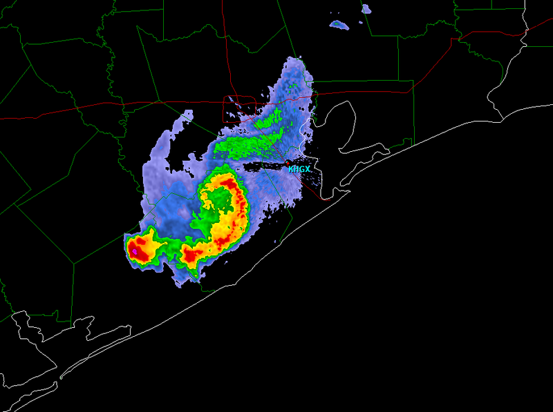
Quite an interesting feature this evening. Almost looks like a tiny hurricane.......MGC
0 likes
-
wbug1
-
Squarethecircle
- Category 5

- Posts: 2165
- Joined: Fri Oct 19, 2007 4:00 pm
- Location: Fairfax, VA


-
Squarethecircle
- Category 5
- Posts: 2165
- Joined: Fri Oct 19, 2007 4:00 pm
- Location: Fairfax, VA
-
wall_cloud

- Professional-Met

- Posts: 401
- Age: 49
- Joined: Sun Dec 04, 2005 7:32 am
- Location: Bartlett, TN
- Contact:
Re:
Squarethecircle wrote::uarrow: Hehe. Any word if there was an actual swirl of low pressure?
obviously. Hard to tell from one image, but I would assume that the image is that of cyclonic end of a bookend vortex. Were there strong winds reported south/southwest of Houston with this storm?
0 likes


-
weatherrabbit_tx

- Category 1

- Posts: 270
- Joined: Wed Dec 21, 2005 3:13 pm
- Location: Kingwood,Tx
- Contact:
Re: Check out Houston radar!
mini 'cane or TS.....lets hope its not a pre cursor......... 
Last edited by weatherrabbit_tx on Fri Feb 22, 2008 2:34 pm, edited 1 time in total.
0 likes
-
Squarethecircle
- Category 5
- Posts: 2165
- Joined: Fri Oct 19, 2007 4:00 pm
- Location: Fairfax, VA
Not even close to the 1999 "Tornadocane" over NC.
http://www.spc.noaa.gov/coolimg/nc_storm/index.html
http://www.spc.noaa.gov/coolimg/nc_storm/index.html
0 likes
Return to “USA & Caribbean Weather”
Who is online
Users browsing this forum: No registered users and 93 guests