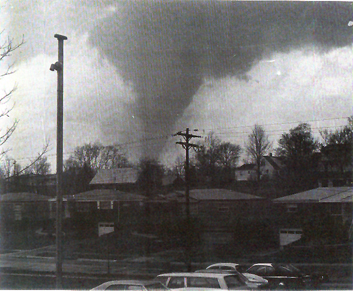
I like to collect tornado pictures, so I thought I'd treat you to some from my collection.
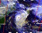
I've found 20 pictures of F5 tornadoes. (Note: The locations listed below are the areas hardest hit, not necessarily where the tornado was photographed.)
Here they are:
April 3, 1956: Grand Rapids, Michigan
May 20, 1957: Ruskin Heights, Missouri
June 20, 1957: Fargo, North Dakota
April 3, 1964: Wichita Falls, Texas
June 8, 1966: Topeka, Kansas
May 15, 1968: Charles City, Iowa
June 13, 1968: Tracy, Minnesota
April 3, 1974: Xenia, Ohio
April 3, 1974: Sayler Park, Ohio
June 13, 1976: Jordan, Iowa
May 31, 1985: Niles, Ohio
March 13, 1990: Hesston, Kansas
April 26, 1991: Andover, Kansas
June 16, 1992: Chandler, Minnesota
July 18, 1996: Oakfield, Wisconsin
May 27, 1997: Jarrell, Texas
April 16, 1998: Waynesboro, Tennessee
May 3, 1999: Moore, Oklahoma
May 4, 2007: Greensburg, Kansas
June 22, 2007: Elie, Manitoba, Canada
Pictures of F5 tornadoes
Moderator: S2k Moderators
Forum rules

The posts in this forum are NOT official forecast and should not be used as such. They are just the opinion of the poster and may or may not be backed by sound meteorological data. They are NOT endorsed by any professional institution or STORM2K.
-
HurricaneBill
- Category 5

- Posts: 3419
- Joined: Sun Apr 11, 2004 5:51 pm
- Location: East Longmeadow, MA, USA
Pictures of F5 tornadoes
Last edited by HurricaneBill on Thu Nov 01, 2007 3:20 pm, edited 1 time in total.
0 likes
-
WindRunner

- Category 5
- Posts: 5803
- Age: 35
- Joined: Fri Jul 29, 2005 8:07 pm
- Location: Warrenton, VA, but Albany, NY for school
- Contact:
-
Extremeweatherguy

- Category 5
- Posts: 11095
- Joined: Mon Oct 10, 2005 8:13 pm
- Location: Florida

-
HurricaneBill
- Category 5
- Posts: 3419
- Joined: Sun Apr 11, 2004 5:51 pm
- Location: East Longmeadow, MA, USA
Re: Pictures of F5 tornadoes
I just changed the Hesston link to a "friendlier" link. It should work now.
0 likes
-
MiamiensisWx
Re: Pictures of F5 tornadoes
Does anyone have an image of the Guin, Alabama F5 from April 3, 1974? It has been noted as one of the strongest AL tornadoes, but information has been quite sparse. It was the longest-lived F5 from the Super Outbreak.
By the way, here is a great site that contains rarer images of several tornadoes from the Super Outbreak. It includes some F4 and F5 events.
http://www.april31974.com/
You forgot the Brandenburg, KY F5 from April 3, 1974. It stripped bark from trees. Additionally, it was among the longest-lived F5 tornadoes from the outbreak.
Information and great images:
http://www.april31974.com/brandenburg_ky_april_3_1974.htm
http://www.april31974.com/our_meade_county_heritage.htm
http://www.april31974.com/overall_destruction_brandenburg.htm
http://www.april31974.com/survivor_stories_from_brandenburg.htm
http://www.april31974.com/more_tornado_stories.htm
http://www.april31974.com/f5_tornado_survior_stories_brandenburg.htm
http://www.april31974.com/f5_tornado_brandenburg.htm
That was a powerful event.
0 likes

Awesome topic since I love tornadoes so much. 
To the topic creator, the 4th photo I've seen similar ones before with a man running and the F5 in the background just like that. The 1st and 2nd photos are one's I've never seen before but that 2nd one looks wicked because it's so vintage!
I haven't seen a lot of those pictures for some reason.
To the topic creator, the 4th photo I've seen similar ones before with a man running and the F5 in the background just like that. The 1st and 2nd photos are one's I've never seen before but that 2nd one looks wicked because it's so vintage!
I haven't seen a lot of those pictures for some reason.
Last edited by Cyclenall on Thu Nov 01, 2007 5:44 pm, edited 1 time in total.
0 likes
-
HarlequinBoy

- Category 5
- Posts: 1400
- Age: 35
- Joined: Wed Nov 29, 2006 1:57 am
- Location: Memphis
-
MiamiensisWx
Re: Pictures of F5 tornadoes
This video includes information and several images about the Guin, AL F5.
http://www.youtube.com/watch?v=xmfk0ItQjBE
http://www.youtube.com/watch?v=xmfk0ItQjBE
Last edited by MiamiensisWx on Thu Nov 01, 2007 8:37 pm, edited 1 time in total.
0 likes

Re: Pictures of F5 tornadoes
The images I find the most impressive are the ones of the '64 Wichita Falls twister and the 1998 Lawrence Co., TN wedge. In that photo the Wichita Falls tornado looks so immense in comparison to the city below. Are there any motion footage videos of that one available online? Also, it's fortunate that the Waynesboro tornado remained over open countryside for the majority of its lifetime. Although it caused a couple fatalities, by the looks of it it certainly had the potential to wreak serious havoc. If there is any video footage of that one I'd also be very interested in seeing it.
0 likes
-
HurricaneBill
- Category 5
- Posts: 3419
- Joined: Sun Apr 11, 2004 5:51 pm
- Location: East Longmeadow, MA, USA
Re: Pictures of F5 tornadoes
Although probably not as well-known as the infamous 1979 F4 tornado, the 1964 Wichita Falls F5 tornado is significant in its own right. It was one of the first tornadoes broadcasted live on television.
The 1966 Topeka F5 tornado was the first tornado to to cause $100 million in damage. If adjusted to inflation, it remains one of the costliest tornadoes in the U.S.
According to a local Native American legend, a hill called Burnett's Mound was supposed to protect the city of Topeka from tornadoes. The F5 tornado moved up and passed directly over Burnett's Mound, and then moved down the hill into Topeka.
The 1968 Tracy, MN tornado is a good example of how a rope tornado can produce F5 damage.
The 1985 Niles, OH tornado was one of only 3 F5 tornadoes during the 1980s. The other two F5s were the Broken Bow, OK tornado of 1982, and the Barneveld, WI tornado of 1984.
0 likes
-
Category 5

- Category 5
- Posts: 10074
- Age: 36
- Joined: Sun Feb 11, 2007 10:00 pm
- Location: New Brunswick, NJ
- Contact:
Re: Pictures of F5 tornadoes
It's cool how they come in all shapes and sizes, when most would picture an F5 as a mile wide bulldozer.
0 likes
Re: Pictures of F5 tornadoes
It's cool how they come in all shapes and sizes, when most would picture an F5 as a mile wide bulldozer.
Absolutely. I find it remarkable how even a small rope funnel can produce F5 level damage. The Tracy, MN tornado of June 1968 and the Oakfield, WI tornado of July 1996 are prime examples of smaller-sized twisters doing F5 damage.
By the way, has anyone seen any photos of the Broken Bow, OK F5 or the March 1966 "Candlestick Park" F5 in Jackson, MS? Also, does anyone know where to find footage from the TV broadcast of the '64 Wichita Falls twister?
Also, is there any veracity to the hypothesis that the quicker the "twisting motion" of the funnel the stronger the winds will be?
0 likes
Re: Pictures of F5 tornadoes
Also, here are links to a few interesting F5 tornado videos I found on YouTube:
June 20, 1957 Fargo, ND F5 tornado:
http://www.youtube.com/watch?v=G-3RlwNSYPk
June 8, 1966 Topeka, KS F5 tornado:
http://www.youtube.com/watch?v=a4dgRgYFyoM
May 31, 1985 F5 tornado at Wheatland, PA:
http://www.youtube.com/watch?v=8qfxGYbfVPQ
June 20, 1957 Fargo, ND F5 tornado:
http://www.youtube.com/watch?v=G-3RlwNSYPk
June 8, 1966 Topeka, KS F5 tornado:
http://www.youtube.com/watch?v=a4dgRgYFyoM
May 31, 1985 F5 tornado at Wheatland, PA:
http://www.youtube.com/watch?v=8qfxGYbfVPQ
0 likes
Re: Pictures of F5 tornadoes
Calasanjy wrote:Also, is there any veracity to the hypothesis that the quicker the "twisting motion" of the funnel the stronger the winds will be?
I think there is IMO since the Elie Manitoba tornado of this year was a rope F5 and there is video of it twisting extremly fast. It's been described as a "drillpress" type.
0 likes
Re: Pictures of F5 tornadoes
I think there is IMO since the Elie Manitoba tornado of this year was a rope F5 and there is video of it twisting extremly fast. It's been described as a "drillpress" type.
I assume that would be the case because the speed of rotation would probably correlate to the wind speed. However, it may be difficult to notice this in larger "wedge" tornadoes where the most intense rotation could be obscured by the surrounding condensation funnel, IMO.
While discussing F5 tornadoes, how many true F5s do you believe have occurred since 1950??? Some ratings are debatable, such as the April 26, 1991 Red Rock, OK F4 and the May 4, 2003 Franklin, MO area tornado. In addition, are meteorologists positive that some tornadoes passing over farm country that received only F1, F2, or F3 ratings may not have been significantly stronger at some point where they were not damaging structures?
0 likes
Re: Pictures of F5 tornadoes
Calasanjy wrote: In addition, are meteorologists positive that some tornadoes passing over farm country that received only F1, F2, or F3 ratings may not have been significantly stronger at some point where they were not damaging structures?
I thought of that about a few tornadoes that have occurred this year including the other major tornado that hit Manitoba like the Elie one which was rated F3 but I thought it looked way stronger like a F4 or F5. When it looked like that at the time, it wasn't near any stuctures or trees so I suspect that maximum strength could have been stronger.
0 likes

Return to “USA & Caribbean Weather”
Who is online
Users browsing this forum: No registered users and 93 guests