

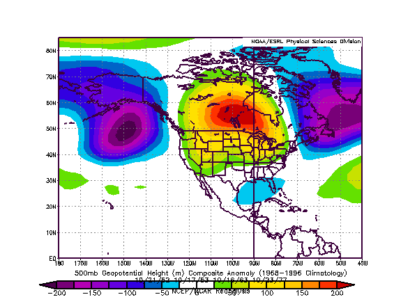
That synoptic setup is reasonably similar to those that occurred in the October 15-31 timeframe during 1952, 1953, 1963, and 1977. The composite 500 mb anomalies for those periods follows:
The following were the highest temperatures for select cities during the four outbreaks of exceptional warmth noted in the composite height anomalies:
October 20-23, 1952:
Bismarck: 79°
Calgary: 73° (22.8°C)
Regina: 68° (20.0°C)
Winnipeg: 73° (22.8°C)
October 16-21, 1953:
Bismarck: 84°
Calgary: 69° (20.6°C)
Regina: 75° (23.9°C)
Winnipeg: 78° (25.6°C)
October 15-18, 1963:
Bismarck: 78°
Calgary: 78° (25.6°C)
Regina: 79° (26.1°C)
Winnipeg: 79° (26.1°C)
October 23-25, 1977:
Bismarck: 78°
Calgary: 70° (21.0°C)
Regina: 70° (20.9°C)
Winnipeg: 74° (23.3°C)
Conclusion:
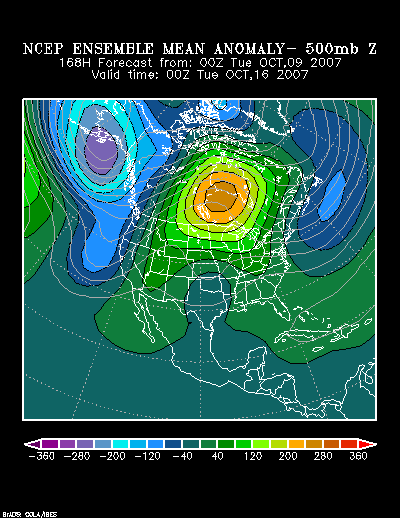
Given that the size of the above normal 500 mb height anomalies is progged to be somewhat less expansive than those in the composite, the warmth to the south of where those anomalies are centered could be somewhat less extreme than occurred in some of the historic examples.
Nonetheless, given the combination of model and ensemble data coupled with the historic examples cited above, I believe Bismarck will likely see its temperature peak at 73° or above during the referenced timeframe. Calgary, Regina, and Winnipeg should all experience a high temperature of 70° (20.9°C) or above. At Regina and Winnipeg, the temperature could reach or exceed 75° (23.9°C).


