Early frost possible for Minneapolis Friday night...

U.S. & Caribbean Weather Discussions and Severe Weather Events

Moderator: S2k Moderators

Forum rules

The posts in this forum are NOT official forecast and should not be used as such. They are just the opinion of the poster and may or may not be backed by sound meteorological data. They are NOT endorsed by any professional institution or STORM2K.

Help Support Storm2K
Message
Author
PhillyWX
Category 1
Category 1
Posts: 494
Joined: Tue Aug 30, 2005 8:54 am
Location: Philly
Contact:

Early frost possible for Minneapolis Friday night...

#1 Postby PhillyWX » Thu Sep 13, 2007 7:29 am

The forecast for Minneapolis for Friday night is calling for lows between 30 and 35. Considering the early cooldown up in the Upper Midwest I have a good feeling they will be in for a good winter. The last 5 early frosts in the Minneapolis area (before 10/1, where the low at MSP was 35 or lower during the month of September) have corresponded to very snowy Upper Midwest winters. 1991, 1995, 1996, 2000, and 2003 were the last five times where Minneapolis had a September frost. In each of those years the following winter was very good for MSP.

91-92: 84.1"
95-96: 55.5"
96-97: 72.1"
00-01: 75.8"
03-04: 66.4"

Going back into the 80's this happened four additional times:

1981, 1983, 1985, 1989

Snowfall those winters:

81-82: 95.0
83-84: 98.4
85-86: 69.5
89-90: 35.5

89-90 was the exception to this trend as it was the only year of the 9 to feature below normal snowfall for MSP (which is around 46" for 122 years of data). 8 of 9 years with above normal snow is a very valid trend for a colder/snowier winter in that location. I do know that many of those winters in Minneapolis were quite cold as well, with temperatures significantly below normal in 83-84, 95-96, and 96-97.

Equating this to Philadelphia...here is what I get for snow/temperatures, with the normals being ~20" of snow and 34.8 for temperature.

TEMP
81-82: 31.2
83-84: 32.7
85-86: 32.7
89-90: 35.7
91-92: 37.6
95-96: 31.9
96-97: 37.6
00-01: 33.7
03-04: 32.8

SNOW
81-82: 25.4
83-84: 21.6
85-86: 16.4
89-90: 17.0
91-92: 4.7
95-96: 65.6
96-97: 12.9
00-01: 26.1
03-04: 18.0

Temp distribution is 3 above, 6 below normal
Snow distribution is 4 above, 5 below normal

Taking this a step further, of those 9 winters, only 89-90 and 91-92 were not neutral or nina at the end of winter. 89-90 was developing a nino by the end of winter while 91-92 was a rather strong nino. With the seven other winters taken to a national level the trend was for colder than normal weather for much of the eastern half of the country.

Image
0 likes   

PhillyWX
Category 1
Category 1
Posts: 494
Joined: Tue Aug 30, 2005 8:54 am
Location: Philly
Contact:

#2 Postby PhillyWX » Thu Sep 13, 2007 1:30 pm

KMSP's MOS at 12z:

AVN:

Code: Select all

MINNEAPOLIS         
 KMSP   GFS MOS GUIDANCE    9/13/2007  1200 UTC                     
 DT /SEPT 13/SEPT 14                /SEPT 15                /SEPT 16
 HR   18 21 00 03 06 09 12 15 18 21 00 03 06 09 12 15 18 21 00 06 12
 N/X                    44          55          36          63    47
 TMP  68 68 63 57 51 47 45 48 52 54 52 47 42 39 37 51 60 62 60 51 48
 DPT  48 43 40 40 38 36 34 34 32 30 29 30 30 29 29 32 32 31 32 39 41
 CLD  BK BK OV BK CL FW SC OV BK SC SC FW CL CL CL CL CL CL CL CL SC
 WDR  26 28 30 31 31 31 31 33 32 33 33 33 33 19 17 18 18 19 17 17 16
 WSP  12 14 11 08 09 09 10 15 14 14 08 05 03 02 03 06 10 13 09 06 06
 P06        12     4     9     1     0     1     0     0     1  2  7
 P12                     9           4           1           1     8
 Q06         0     0     0     0     0     0     0     0     0  0  0
 Q12                     0           0           0           0     0
 T06      7/ 0  3/ 9  1/ 0  0/ 2  0/ 1  0/ 4  0/ 0  0/ 0  0/ 5  0/ 0
 T12            7/ 9        1/ 3        0/ 4        0/ 0     0/10   
 POZ   0  0  0  0  0  0  0  0  0  0  0  1  2  3  0  0  0  0  0  0  1
 POS   0  0  0  0  0  0  0  0 11 17 30 63 54 37  0  0  0  0  0  0  0
 TYP   R  R  R  R  R  R  R  R  R  R  R  S  S  R  R  R  R  R  R  R  R
 SNW                     0                       0                 0
 CIG   8  8  8  8  8  8  8  8  6  8  8  8  8  8  8  8  8  8  8  8  8
 VIS   7  7  7  7  7  7  7  7  7  7  7  7  7  7  7  7  7  7  7  7  7
 OBV   N  N  N  N  N  N  N  N  N  N  N  N  N  N  N  N  N  N  N  N  N


ETA

Code: Select all

MINNEAPOLIS         
 KMSP   ETA MOS GUIDANCE    9/13/2007  1200 UTC                     
 DT /SEPT 13/SEPT 14                /SEPT 15                /SEPT 16
 HR   18 21 00 03 06 09 12 15 18 21 00 03 06 09 12 15 18 21 00 06 12
 N/X                    44          53          41          63    49
 TMP  62 63 57 52 49 46 44 46 51 51 48 45 44 42 42 51 59 63 61 53 50
 DPT  51 47 43 40 39 38 37 35 32 31 31 33 35 35 36 37 38 39 40 45 45
 CLD  BK BK BK SC FW OV BK OV OV BK CL CL CL CL CL CL CL CL BK BK CL
 WDR  29 29 30 30 30 31 32 33 32 33 32 26 27 21 18 19 19 18 17 18 14
 WSP  11 13 12 10 10 11 11 16 14 12 07 03 04 02 04 08 12 14 09 10 06
 P06         8     4     5     3    10     0     0     2     3  9 16
 P12                     7          10           0           5    17
 Q06         0     0     0     0     0     0     0     0     0  0  0
 Q12                     0           0           0           0     0
 T06     14/ 0  0/ 6  3/ 0  0/ 0  1/ 0  0/ 5  0/ 0  0/ 0  4/ 0999/99
 T12           14/ 6        3/ 0        1/ 5        0/ 0   999/99   
 SNW                     0                       0                 0
 CIG   6  8  8  8  8  7  7  5  6  7  8  8  8  8  8  8  8  8  8  8  8
 VIS   7  7  7  7  7  7  7  7  7  7  7  7  7  7  7  7  7  7  7  7  7
 OBV   N  N  N  N  N  N  N  N  N  N  N  N  N  N  N  N  N  N  N  N  N


If we split the uprights, it's 38. Could be cooler if winds go completely calm. Should be a close call.
0 likes   

RL3AO
Moderator-Pro Met
Moderator-Pro Met
Posts: 16308
Joined: Thu Jun 14, 2007 10:03 pm
Location: NC

#3 Postby RL3AO » Thu Sep 13, 2007 3:11 pm

It got down to 39 or 40 in Minneapolis on Wednesday morning.
0 likes   

PhillyWX
Category 1
Category 1
Posts: 494
Joined: Tue Aug 30, 2005 8:54 am
Location: Philly
Contact:

Re:

#4 Postby PhillyWX » Thu Sep 13, 2007 5:20 pm

RL3AO wrote:It got down to 39 or 40 in Minneapolis on Wednesday morning.


I didn't realize that. I had a sleepless night and saw the ZFP for them in between Humberto clicking and it got my mind moving. I knew they had a couple of cool nights up there but didn't think they got into the 30's in the region.

I used to live in Minneapolis until 01 and spotted an early season connection between early frosts and cold/snow for you guys up there a number of years back. '95 and '96, two of earlier Falls I remember up there, both were nasty winters with '96 being where Tower got to -60 (MSP had -34 I believe and I still remember every moment of trying to start my car that day) and '97 being the Red River Blizzard year. I don't remember '03 there but I know where it was pretty cold (by Philadelphia standards) in January -- probably the coldest sustained period I dealt with until February 07 in Philadelphia.

FWIW, I sent this and my unscripted thoughts for winter to Dave Dahl at KSTP today and got a response saying we're on the same page. I also got an advance copy of his winter forecast and it's in line with my findings. Of course he's using nino/nina and other data to correlate (which is what I would expect a met to do) but from a climo perspective, he's got a lot of ammo behind him to go with the forecast he is going to issue.
0 likes   

RL3AO
Moderator-Pro Met
Moderator-Pro Met
Posts: 16308
Joined: Thu Jun 14, 2007 10:03 pm
Location: NC

Re: Re:

#5 Postby RL3AO » Thu Sep 13, 2007 7:11 pm

PhillyWX wrote:
RL3AO wrote:It got down to 39 or 40 in Minneapolis on Wednesday morning.


I didn't realize that. I had a sleepless night and saw the ZFP for them in between Humberto clicking and it got my mind moving. I knew they had a couple of cool nights up there but didn't think they got into the 30's in the region.


There were frost/freeze advisories from St. Cloud northward on Tue/Wed. It looks like the advisories are all in the Dakotas tonight.
0 likes   

PhillyWX
Category 1
Category 1
Posts: 494
Joined: Tue Aug 30, 2005 8:54 am
Location: Philly
Contact:

#6 Postby PhillyWX » Fri Sep 14, 2007 7:05 am

AVN (GFS) 0z for MSP:

Code: Select all

MINNEAPOLIS         
 KMSP   GFS MOS GUIDANCE    9/14/2007  0000 UTC                     
 DT /SEPT 14            /SEPT 15                /SEPT 16          / 
 HR   06 09 12 15 18 21 00 03 06 09 12 15 18 21 00 03 06 09 12 18 00
 X/N                    57          37          64          48    76
 TMP  50 46 43 48 52 55 54 48 43 39 38 52 60 63 61 56 52 50 49 70 74
 DPT  36 35 34 34 31 28 26 28 28 28 28 32 33 33 35 39 40 42 43 51 53
 CLD  SC SC OV OV BK SC SC CL CL CL CL CL CL FW SC CL CL CL CL FW CL
 WDR  30 31 31 33 32 32 32 32 30 21 18 20 19 20 18 18 18 16 16 18 16
 WSP  09 09 10 15 14 14 09 04 02 02 02 07 12 13 09 08 07 05 05 10 08
 P06         9     0     1     0     2     0     3     7     7  6  6
 P12                     1           2           3          11     8
 Q06         0     0     0     0     0     0     0     0     0  0  0
 Q12                     0           0           0           0     0
 T06      1/ 0  0/ 1  3/ 0  0/ 4  0/ 0  0/ 1  0/ 5  0/ 7  1/ 0  2/ 0
 T12            1/ 1        3/ 4        0/ 1        0/ 7     1/ 0   
 POZ   0  0  0  0  0  0  0  0  3  3  0  0  0  0  0  0  0  0  0  0  0
 POS   0  0  0  0  0  0 15 16 38 39  0  0  0  0  1  0  0  0  1  0  0
 TYP   R  R  R  R  R  R  R  R  R  R  R  R  R  R  R  R  R  R  R  R  R
 SNW                                 0                       0       
 CIG   6  8  8  6  7  8  8  8  8  8  8  8  8  8  8  8  8  8  8  8  8
 VIS   7  7  7  7  7  7  7  7  7  7  7  7  7  7  7  7  7  7  7  7  7
 OBV   N  N  N  N  N  N  N  N  N  N  N  N  N  N  N  N  N  N  N  N  N


ETA

Code: Select all

MINNEAPOLIS         
 KMSP   ETA MOS GUIDANCE    9/14/2007  0000 UTC                     
 DT /SEPT 14            /SEPT 15                /SEPT 16          / 
 HR   06 09 12 15 18 21 00 03 06 09 12 15 18 21 00 03 06 09 12 18 00
 X/N                    50          40          63          48    70
 TMP  48 45 42 44 47 49 48 45 43 42 41 50 58 62 60 54 51 50 50 65 67
 DPT  35 34 33 32 31 30 30 32 34 34 35 36 36 37 38 43 46 46 46 50 54
 CLD  CL SC OV OV OV BK CL CL CL CL CL CL CL CL SC SC CL CL SC SC FW
 WDR  31 31 32 33 33 33 32 31 26 21 17 19 19 19 18 19 20 19 15 22 19
 WSP  09 09 11 15 15 12 08 03 02 02 05 08 11 14 09 09 07 06 05 08 07
 P06         7     3     5     0     0     2     2     1     6  3  0
 P12                     5           3           3           9     6
 Q06         0     0     0     0     0     0     0     0     0  0  0
 Q12                     0           0           0           0     0
 T06      7/ 0  1/ 1  0/ 0  0/ 0  5/ 1  2/ 1  4/ 0  0/ 2 10/ 1999/99
 T12            7/ 1        0/ 0        7/ 1        4/ 2   999/99   
 SNW                                 0                       0       
 CIG   8  8  6  5  6  6  8  8  8  8  8  8  8  8  8  8  8  8  8  8  8
 VIS   7  7  7  7  7  7  7  7  7  7  7  7  7  7  7  7  7  7  7  7  7
 OBV   N  N  N  N  N  N  N  N  N  N  N  N  N  N  N  N  N  N  N  N  N


37 and 40 = 38.5 if split. NWS forecasting 30 to 35. Brrr.
0 likes   

PhillyWX
Category 1
Category 1
Posts: 494
Joined: Tue Aug 30, 2005 8:54 am
Location: Philly
Contact:

Re: Re:

#7 Postby PhillyWX » Fri Sep 14, 2007 7:05 am

RL3AO wrote:
PhillyWX wrote:
RL3AO wrote:It got down to 39 or 40 in Minneapolis on Wednesday morning.


I didn't realize that. I had a sleepless night and saw the ZFP for them in between Humberto clicking and it got my mind moving. I knew they had a couple of cool nights up there but didn't think they got into the 30's in the region.


There were frost/freeze advisories from St. Cloud northward on Tue/Wed. It looks like the advisories are all in the Dakotas tonight.


There are frost advisories down to NE MO and freeze warnings for the Quad Cities tonight.
0 likes   

RL3AO
Moderator-Pro Met
Moderator-Pro Met
Posts: 16308
Joined: Thu Jun 14, 2007 10:03 pm
Location: NC

#8 Postby RL3AO » Fri Sep 14, 2007 8:20 am

The entire upper midwest is under frost/freeze advisories. It should be the first frost of the year for Minneapolis. The average first frost is October 10. And it will be near 80 again next week. :lol:
0 likes   

PhillyWX
Category 1
Category 1
Posts: 494
Joined: Tue Aug 30, 2005 8:54 am
Location: Philly
Contact:

Re:

#9 Postby PhillyWX » Fri Sep 14, 2007 2:19 pm

RL3AO wrote:The entire upper midwest is under frost/freeze advisories. It should be the first frost of the year for Minneapolis. The average first frost is October 10. And it will be near 80 again next week. :lol:


Gotta love September in Minnesota! I remember those days where it would be 35 in the AM and 75 by the end of the day! I heard that International Falls got their first snowfall of the year already.
0 likes   

User avatar
Aquawind
Category 5
Category 5
Posts: 6714
Age: 62
Joined: Mon Jun 16, 2003 10:41 pm
Location: Salisbury, NC
Contact:

Re: Re:

#10 Postby Aquawind » Fri Sep 14, 2007 4:25 pm

PhillyWX wrote:
RL3AO wrote:The entire upper midwest is under frost/freeze advisories. It should be the first frost of the year for Minneapolis. The average first frost is October 10. And it will be near 80 again next week. :lol:


Gotta love September in Minnesota! I remember those days where it would be 35 in the AM and 75 by the end of the day! I heard that International Falls got their first snowfall of the year already.


This is classsic.. inferno for the State Fair then a fropa from Canada and it's time for the winter gear for half the day at least..lol Frost = Dead bugs 8-)
0 likes   

PhillyWX
Category 1
Category 1
Posts: 494
Joined: Tue Aug 30, 2005 8:54 am
Location: Philly
Contact:

Re: Re:

#11 Postby PhillyWX » Fri Sep 14, 2007 9:26 pm

Aquawind wrote:
PhillyWX wrote:
RL3AO wrote:The entire upper midwest is under frost/freeze advisories. It should be the first frost of the year for Minneapolis. The average first frost is October 10. And it will be near 80 again next week. :lol:


Gotta love September in Minnesota! I remember those days where it would be 35 in the AM and 75 by the end of the day! I heard that International Falls got their first snowfall of the year already.


This is classsic.. inferno for the State Fair then a fropa from Canada and it's time for the winter gear for half the day at least..lol Frost = Dead bugs 8-)


That's the one thing I miss about Minnesota....a very short bug season.

BTW, MSP is at 47 with MOS ranging from 36 (GFS) to 40 (ETA).
0 likes   

PhillyWX
Category 1
Category 1
Posts: 494
Joined: Tue Aug 30, 2005 8:54 am
Location: Philly
Contact:

#12 Postby PhillyWX » Sun Sep 16, 2007 6:29 am

MSP got to 36, which tied a record. Much of the rest of the region was colder, with a freeze in the suburbs just outside of the heat island. High today up there? At least 75!
0 likes   

RL3AO
Moderator-Pro Met
Moderator-Pro Met
Posts: 16308
Joined: Thu Jun 14, 2007 10:03 pm
Location: NC

#13 Postby RL3AO » Sun Sep 16, 2007 10:23 am

Yep. Severe thunderstorms maybe on Tuesday and Wednesday with 80s by Thursday. Welcome to September in Minnesota.

Also, the tied record low at the MSP airport was the first record low since August 2004. There has been 11 record highs during that time.
0 likes   

PhillyWX
Category 1
Category 1
Posts: 494
Joined: Tue Aug 30, 2005 8:54 am
Location: Philly
Contact:

Re:

#14 Postby PhillyWX » Sun Sep 16, 2007 10:26 am

RL3AO wrote:Yep. Severe thunderstorms maybe on Tuesday and Wednesday with 80s by Thursday. Welcome to September in Minnesota.


That's like our March here -- only we get backdoor fronts to ruin our warmth!

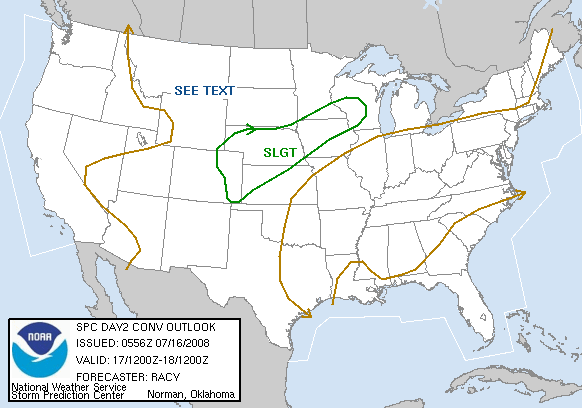
Good luck with the severe tomorrow and Tues...it looks pretty interesting set-up wise. 30% probs right over MSP and extending down to you guys in Red Wing.

Image
0 likes   


Return to “USA & Caribbean Weather”

Who is online

Users browsing this forum: No registered users and 28 guests