Winter 2007-08: Preliminary Thoughts

Winter Weather Discussion

Moderator: S2k Moderators

Forum rules

The posts in this forum are NOT official forecast and should not be used as such. They are just the opinion of the poster and may or may not be backed by sound meteorological data. They are NOT endorsed by any professional institution or STORM2K.

Help Support Storm2K
Message
Author
donsutherland1
S2K Analyst
S2K Analyst
Posts: 2718
Joined: Mon Sep 15, 2003 8:49 pm
Location: New York

Winter 2007-08: Preliminary Thoughts

#1 Postby donsutherland1 » Sat Oct 06, 2007 10:32 pm

Winter 2007-08 looks to be warmer than normal across much of the United States. The Northeast will likely see temperatures average about 1.5°-2.5° above normal for the December-February period. The Mid-Atlantic and Southeast regions will likely see readings average 2°-3° above normal. The Western United States will likely see temperatures average around 1° above normal except for the Pacific Northwest where readings could be somewhat below normal to near normal. No Kocin-Uccellini snowstorms are likely.

Temperature Snapshot:
• Northeast: Warmer to much warmer than normal
• Mid-Atlantic: Warmer to much warmer than normal
• Southeast: Warmer to much warmer than normal
• Ohio Valley: Warmer than normal
• Northern Plains: Warmer than normal
• Central Plains: Warmer than normal
• Southern Plains: Warmer to much warmer than normal
• Pacific Northwest: Somewhat cooler than normal to near normal
• California/Southwest: Near normal to somewhat warmer than normal

Precipitation Snapshot:
• Northeast: Near normal
• Mid-Atlantic: Near normal (below normal in the lower Mid-Atlantic region)
• Southeast: Below normal
• Ohio Valley: Near normal to above normal
• Northern Plains: Near normal
• Central Plains: Near normal
• Southern Plains: Below normal to near normal
• Pacific Northwest: Above to much above normal
• California/Southwest: Below normal to near normal

Snowfall Estimates for Select Cities:
Baltimore: 12”-17”
Boston: 25”-35”
Burlington: 75”-85”
Chicago: 40”-50”
New York City: 10”-20”
Philadelphia: 10”-20”
Pittsburgh: 25”-35”
Providence: 20”-30”
Richmond: <6”
St. Louis: 15”-25”
Washington, DC: 7”-12”

ANALYSIS:

ENSO Forecast:
The overwhelming share of the CFS’s ensemble members and the ECMWF’s latest ENSO forecast suggest that a moderate La Niña is likely to predominate through much of the upcoming winter.

Image

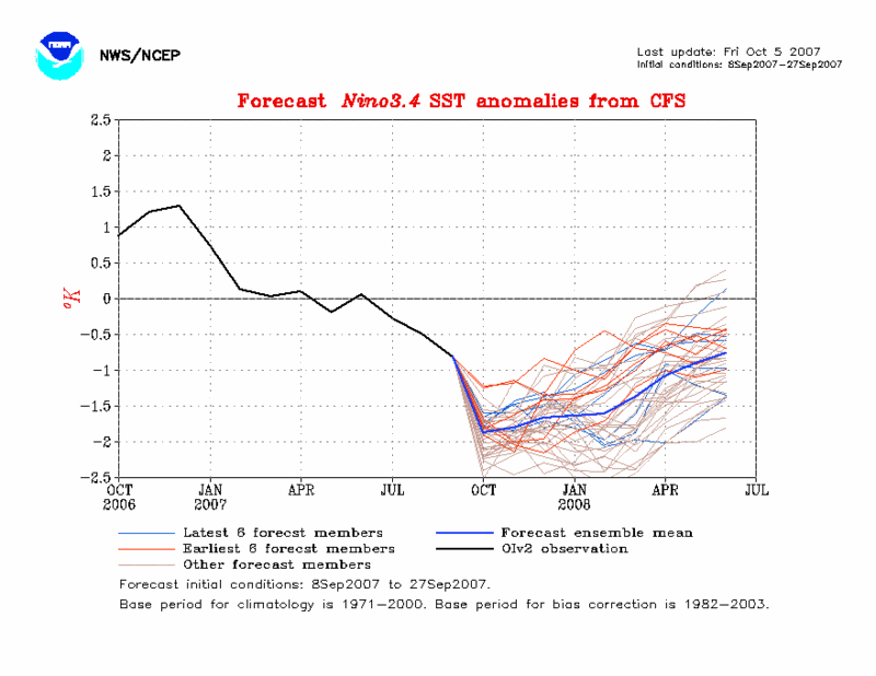
Most early model guidance had pointed to a weak to borderline moderate La Niña. Given the model trends and recent evolution of the present ENSO region anomalies, I lean toward the idea of a moderate La Niña.

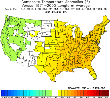
The August-September Multivariate ENSO Index (MEI) declined to -1.109. The fall of 0.675 from the July-August period was the second sharpest for August-September since recordkeeping began in 1950. In 5/6 (83%) cases in which the August-September MEI fell by 0.300 or more from the preceding period, the MEI for November-December through February-March averaged lower than that for the August-September timeframe. In the single exception (2001-02), it averaged .152 higher. Therefore, I believe the MEI will likely average -0.75 or below for the November-December 2007 through February-March 2008 timeframe. The composite temperature anomalies for the December-February timeframe for such situations is as follows:

Image

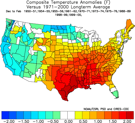
It should be noted that applying only winters beginning in 1979-80 that met such criteria yielded a much smaller area of cool anomalies and a much more expansive area of warm anomalies, including over the Northern Plains. This would fit well with the observed trend toward warming winters in recent decades where the northern latitudes have experienced among the largest extent of warming.

ENSO: Extreme Situations:
2007 is only the 4th year on record in which the ENSO Region 1+2 temperature fell below 19.5°C at the same time when the ENSO Region 3.0 reading was below 24.5°C. The other years in which that occurred were 1996, 1999, and 2001.

The composite anomalies for the winters (December-February) that followed such situations were generally warmer than normal nationwide.

Image

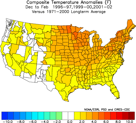
In general the areas that were most likely to see warmer than normal readings were the Northeast (3/3 cases) and the Mid-Atlantic (3/3 cases). With the single exception of the Northern Plains and part of the Central Plains States, all other areas generally saw near normal to above normal readings. In one case, the Northern Plains and a portion of the Central Plains region saw a colder than normal winter. However, considering that the past ten years have seen this region average much warmer than normal in terms of the 10-year anomaly relative to the 1971-2000 base, odds are against that region witnessing a colder than normal winter.

Models:
The CFS is currently indicating a warmer than normal winter in the East and generally colder than normal in the West (particularly the Pacific Northwest and western Canada).

Image

The ECMWF’s seasonal idea is similar, though with more widespread warmth. Such an outcome is well-supported by past precedent with respect to sea surface temperature anomalies (SSTAs).

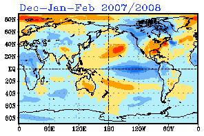
Sea Surface Temperature Anomalies:
Both the latest December-February SSTA forecasts from the CFS and IRI highlight the following key anomalies:

• Cool SSTAs off the West Coast
• A substantial area of warmth off the Atlantic Coast
• General warmer than normal SSTAs in the Bay of Baffin/Davis Straits area

IRI SSTA Forecast (December-February):
Image

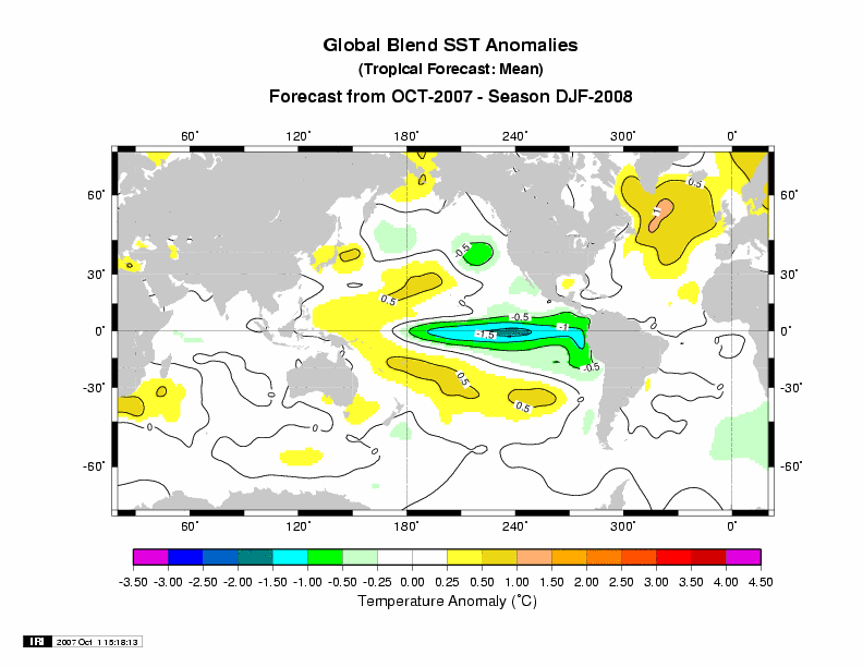
Such a situation has generally featured a winter with warmth in the East and colder than normal readings in the West. In all cases, the East was generally warmer than normal. The composite for such winters is below:

Image

That composite idea matches very well with the latest CFS model guidance. Moreover, if one takes all winters subsequent to 1979-80 with SSTAs similar to what is forecast for December-February of 2007-08, the cool anomalies give way to near normal readings, while the warm anomalies persist. That fits well with the observed warming that has been ongoing in recent decades.

Two of the seasons in question coincided with the extreme ENSO conditions noted earlier in this discussion: 1999-00 and 2001-02. One of those seasons (2001-02) also saw a substantial drop in the MEI in the August-September timeframe as occurred this year.

Local Temperature/Precipitation Profile:
Recent temperature and precipitation patterns have been consistent with a profile that typically witnessed much below normal snowfall in the East, especially in the Northeast. Average snowfall for such seasons came to 10.5” in Baltimore, 23.5” in Boston, 13.0” in New York City, and 9.6” in Washington, DC (DCA). Such snowfall is reasonably consistent with moderate/strong La Niña-negative PDO winters.

Anecdote:
There is an old saying that “Should in mud and slush the first snow fall, look for a mild winter, and a muddy withal.” Given the warmth that is likely to predominate this month with a cool period in the middle before renewed warmth returns, it is entirely possible that the season’s first snow in parts of the United States could fall on the proverbial “mud and slush.” If typical moderate La Niña conditions prevail, that anecdote could come true with a vengeance. Time will tell.
0 likes   

VoodooCadillac
Tropical Depression
Tropical Depression
Posts: 82
Joined: Wed Dec 14, 2005 8:56 pm
Location: Fort Collins, Colorado

Re: Winter 2007-08: Preliminary Thoughts

#2 Postby VoodooCadillac » Mon Oct 08, 2007 8:04 am

Boy...........is that discouraging. A typically thorough, well thought out, and easy to follow post Don, even though I wish the conclusion were different. Thanks.
0 likes   

User avatar
AnnularCane
S2K Supporter
S2K Supporter
Posts: 2862
Joined: Thu Jun 08, 2006 9:18 am
Location: Wytheville, VA

Re: Winter 2007-08: Preliminary Thoughts

#3 Postby AnnularCane » Mon Oct 08, 2007 9:45 am

That is just depressing. I hope you are wrong. I am tired of warm weather. :x
0 likes   

User avatar
CaptinCrunch
S2K Supporter
S2K Supporter
Posts: 8728
Age: 57
Joined: Mon Nov 03, 2003 4:33 pm
Location: Kennedale, TX (Tarrant Co.)

#4 Postby CaptinCrunch » Mon Oct 08, 2007 10:16 am

Hate to say it, but I agree fully with this early outlook. I fully believe that this will be a record top 10 warm winter for the U.S as a whole. It may also be a record warm winter on average for many parts of the country as well, with the only exception being the Pacific NW.
0 likes   

User avatar
carversteve
Tropical Storm
Tropical Storm
Posts: 161
Joined: Sat Aug 18, 2007 7:40 am

Re: Winter 2007-08: Preliminary Thoughts

#5 Postby carversteve » Mon Oct 08, 2007 11:54 am

Man i hope this doesn't happen..i have had my fill of warm..no not warm..hot weather!!!Here it is oct 8th and it is almost 90 degrees :grr: The leaves are awful looking..very drab in color.
0 likes   

User avatar
gboudx
S2K Supporter
S2K Supporter
Posts: 4080
Joined: Thu Sep 04, 2003 1:39 pm
Location: Rockwall, Tx but from Harvey, La

Re:

#6 Postby gboudx » Mon Oct 08, 2007 4:03 pm

CaptinCrunch wrote:Hate to say it, but I agree fully with this early outlook. I fully believe that this will be a record top 10 warm winter for the U.S as a whole. It may also be a record warm winter on average for many parts of the country as well, with the only exception being the Pacific NW.


Well, I guess we can look forward to some decent gas and electric bills then. You know how it is here though, if we don't get that rain, the "lakes" don't like that.
0 likes   

JBG
Tropical Storm
Tropical Storm
Posts: 146
Joined: Fri Apr 29, 2005 12:34 pm
Location: New York City area
Contact:

Re: Winter 2007-08: Preliminary Thoughts

#7 Postby JBG » Tue Oct 09, 2007 12:54 am

Even 1996-7 had the "April Fools Day" storm.
0 likes   

wobblehead
Tropical Storm
Tropical Storm
Posts: 133
Joined: Fri Jul 15, 2005 12:51 pm
Location: Mobile.Al

#8 Postby wobblehead » Wed Oct 10, 2007 10:04 pm

For what its worth the farmer's almanac predicts this winter to be the warmest winter in the last 100 years.
0 likes   

User avatar
Extremeweatherguy
Category 5
Category 5
Posts: 11095
Joined: Mon Oct 10, 2005 8:13 pm
Location: Florida

Re:

#9 Postby Extremeweatherguy » Wed Oct 10, 2007 10:19 pm

wobblehead wrote:For what its worth the farmer's almanac predicts this winter to be the warmest winter in the last 100 years.
Where are you seeing that? From what I have found, it seems like they are actually predicting a cold winter...

http://www.farmersalmanac.com/2007_2008 ... er_outlook

Image
0 likes   

JBG
Tropical Storm
Tropical Storm
Posts: 146
Joined: Fri Apr 29, 2005 12:34 pm
Location: New York City area
Contact:

Re: Winter 2007-08: Preliminary Thoughts

#10 Postby JBG » Wed Oct 10, 2007 11:17 pm

donsutherland1 wrote:No Kocin-Uccellini snowstorms are likely.
Doesn't NAO have some role in this? Wasn't there a major "Kocin-Uccellini" storm around January 26, 2000 (not sure of exact date but I remember it being Tuesday-Wednesday after January 24 and before January 31, 2000)? And what about the New Years Day 1971 storm? Wasn't that under similar ENSO conditions?

donsutherland1 wrote:Local Temperature/Precipitation Profile:
Recent temperature and precipitation patterns have been consistent with a profile that typically witnessed much below normal snowfall in the East, especially in the Northeast. Average snowfall for such seasons came to 10.5” in Baltimore, 23.5” in Boston, 13.0” in New York City, and 9.6” in Washington, DC (DCA). Such snowfall is reasonably consistent with moderate/strong La Niña-negative PDO winters.

Does "negative PDO" mean "cold-phase" PDO?
0 likes   

User avatar
Ptarmigan
Category 5
Category 5
Posts: 5313
Joined: Wed Aug 16, 2006 9:06 pm

Re: Winter 2007-08: Preliminary Thoughts

#11 Postby Ptarmigan » Thu Oct 11, 2007 12:15 am

Good posts Don! La Nina for us means warmer and drier winters. However, sometimes big freezes have occurred during La Nina years, most notably in Jan-Feb 1951 and Feb 1989, which were La Nina years. They can last for a few days. The reason for that is the air is drier and less cloud cover, so it cool down a lot easily. Sometimes, we get ice storms and even snow. Snow rarely falls during La Nina. It's the Neutral years that get the most snow for Houston. Also, North Atlantic Oscillation plays a role. A negative NAO can give major Arctic blasts, like in 1989.
0 likes   

User avatar
Ptarmigan
Category 5
Category 5
Posts: 5313
Joined: Wed Aug 16, 2006 9:06 pm

Re: Winter 2007-08: Preliminary Thoughts

#12 Postby Ptarmigan » Thu Oct 11, 2007 12:16 am

JBG wrote:
donsutherland1 wrote:No Kocin-Uccellini snowstorms are likely.
Doesn't NAO have some role in this? Wasn't there a major "Kocin-Uccellini" storm around January 26, 2000 (not sure of exact date but I remember it being Tuesday-Wednesday after January 24 and before January 31, 2000)? And what about the New Years Day 1971 storm? Wasn't that under similar ENSO conditions?

donsutherland1 wrote:Local Temperature/Precipitation Profile:
Recent temperature and precipitation patterns have been consistent with a profile that typically witnessed much below normal snowfall in the East, especially in the Northeast. Average snowfall for such seasons came to 10.5” in Baltimore, 23.5” in Boston, 13.0” in New York City, and 9.6” in Washington, DC (DCA). Such snowfall is reasonably consistent with moderate/strong La Niña-negative PDO winters.

Does "negative PDO" mean "cold-phase" PDO?


Negative PDO is cool phase PDO. I am certain the negative PDO is part of the reason why WPAC is less active.
0 likes   

JBG
Tropical Storm
Tropical Storm
Posts: 146
Joined: Fri Apr 29, 2005 12:34 pm
Location: New York City area
Contact:

Re: Winter 2007-08: Preliminary Thoughts

#13 Postby JBG » Thu Oct 11, 2007 12:32 am

Ptarmigan wrote:Negative PDO is cool phase PDO. I am certain the negative PDO is part of the reason why WPAC is less active.
Excuse my ignorance. What is WPAC?
0 likes   

User avatar
jimvb
Category 1
Category 1
Posts: 397
Joined: Wed Sep 15, 2004 8:03 am
Location: Richmond, Virginia
Contact:

Re: Winter 2007-08: Preliminary Thoughts

#14 Postby jimvb » Thu Oct 11, 2007 9:53 am

An assessment of winter weather 2007-2008 needs to take into effect the huge amount of sea ice that melted this summer. In most summers, most of the Arctic ocean is covered with ice, but this year half of it was gone. The ice pack is beginning to grow now, but there is all this open water in the Arctic now. How will this affect our weather?

It seems to me that it might make it warmer than usual all around, but it might not be that simple. The eastern part of the US and Canada is on the iced side of the Arctic ocean; western Alaska and eastern Russia are on the water side. I am seeing some interesting trends already. For example, Verkhoyansk, Russia, averaging 60 F at the solstices, plus in the summer and minus in the winter, should now average about 0 F. Their predictions now call for highs in the teens and 20s, substantially above average. Throughout all the Arctic lands, the snow cover is greater than that of last year, presumably due to more moisture in the air because of warmer temperatures.

So what does that mean for us? Much warmer temperatures? More snow, because of greater amounts of moisture around? I would expect a persistent low to form in the ice-free Arctic and highs to form in eastern Russia and the eastern Canadian Arctic islands. Could that Canadian high throw tongues of cold air in our direction?
0 likes   

User avatar
Extremeweatherguy
Category 5
Category 5
Posts: 11095
Joined: Mon Oct 10, 2005 8:13 pm
Location: Florida

#15 Postby Extremeweatherguy » Thu Oct 11, 2007 4:33 pm

To tell you the truth..I am not too worried about the sea ice loss. Why? Because the added snowpack on land has made up for (IMO) some of the effect of the reduced ice. Also, with colder winter temperatures ahead and the fact that La Nina years are usually colder than normal in the arctic...I think the ice will be back to near normal limits before it is all said and done this winter. Sure there may be minor impacts to the overall pattern, but I do not expect to see anything overly drastic (due to the ice loss) in the months ahead.
Last edited by Extremeweatherguy on Thu Oct 11, 2007 9:13 pm, edited 1 time in total.
0 likes   

User avatar
Ptarmigan
Category 5
Category 5
Posts: 5313
Joined: Wed Aug 16, 2006 9:06 pm

Re: Winter 2007-08: Preliminary Thoughts

#16 Postby Ptarmigan » Thu Oct 11, 2007 8:32 pm

JBG wrote:Excuse my ignorance. What is WPAC?


WPAC is short for West Pacific, where typhoons form.
0 likes   

JBG
Tropical Storm
Tropical Storm
Posts: 146
Joined: Fri Apr 29, 2005 12:34 pm
Location: New York City area
Contact:

Re:

#17 Postby JBG » Thu Oct 11, 2007 11:05 pm

Extremeweatherguy wrote:To tell you the truth..I am not too worried about the sea ice loss. Why? Because the added snowpack on land has made up for (IMO) some of the effect of the reduced ice. Also, with colder winter temperatures ahead and the fact that La Nina years are usually colder than normal in the arctic...I think the ice will be back to near normal limits before it is all said and done this winter. Sure there may be minor impacts to the overall pattern, but I do not expect to see anything overly drastic (due to the ice loss) in the months ahead.

As the otherwise alarmist New York Times article on the sea ice pointed out, some of this may have had to do with local phenomena such as strong southerly winds. I have heard nothing to suggest major de-icing in the eastern part of the Arctic and/or the Antarctic.
0 likes   

iancurtis
Tropical Wave
Tropical Wave
Posts: 1
Joined: Fri Oct 12, 2007 6:56 am

Re: Winter 2007-08: Preliminary Thoughts

#18 Postby iancurtis » Fri Oct 12, 2007 7:20 am

I think it's almost comical for any person, let alone a person trained in weather, to predict what's going to happen during the next 6 months. I live in northern Maryland and the meteorologists around here have enough problems predicting winter weather 2 days in advance. Even with all their various computer models and collective heads, the best they're going to give you is a lot of tap dancing(meaning countless scenerios to cover their butts) until the storm is practically at your doorstep. Five-day forecasts constantly change from day to day, making them quite ridiculous too. I know it's fun to read these long range forecasts and I've been a diehard Farmer's Almanac fan for years, but in the end, we all know it's laughable. The general consensus is that the Mid-Atlantic states will experience a milder than average winter with below average snowfall. Well, all it takes is one huge snowstorm to roll up the coast, dump about 20" inches and just like that, the area I live in has just about met it's yearly quota for snow. The rest of the winter could produce nothing and it still would end up a normal season statistically for the white stuff. We could have brutally cold weather for a stretch of a week or two and by the end of the month, no matter how mild the other days were, will average out to normal. At least in this area, there is no such thing as a winter that's constantly mild or constantly cold. It just doesn't work that way in the Mid-Atlantic. So for you snow lovers, don't let these forecasts upset you. You'll get your share of accumulating precipitation but you'll have to put up with those cold rains and highs in the upper 40's to low 50's quite often too. It's the price you pay to living around here. Here's my prediction for the winter and it's only a gut feeling based on nothing scientific:
We've had an incredibly dry and hot summer here in northern Maryland and since Mother Nature always has a way of balancing out weather, I really do think this upcoming winter is going to be colder and snowier than average. But apparently, I'm fairly alone in that synopsis.
0 likes   

User avatar
jimvb
Category 1
Category 1
Posts: 397
Joined: Wed Sep 15, 2004 8:03 am
Location: Richmond, Virginia
Contact:

#19 Postby jimvb » Fri Oct 12, 2007 7:37 am

I live in Virginia. I think the weather in the East is going to be warmer and snowier than usual. The overall trend is towards warmth but we are on the ice side of the truncated Arctic ice sheet.
0 likes   

User avatar
CaptinCrunch
S2K Supporter
S2K Supporter
Posts: 8728
Age: 57
Joined: Mon Nov 03, 2003 4:33 pm
Location: Kennedale, TX (Tarrant Co.)

Re: Winter 2007-08: Preliminary Thoughts

#20 Postby CaptinCrunch » Fri Oct 12, 2007 10:19 am

A moderate La Nina thru late December then goin to a weak La Nina by mid January then netural by early April.

Breaking the U.S into 6 parts heres your outlook.

NW - Above normal Precip, Normal to below normal Temps.

SW - Below normal Precip, above normal Temps.

Northeren Plains - Normal to above normal Precip, Normal to below normal Temps.

Southeren Plains - Normal to below normal Precip, Normal to above normal Temps.

NE - Normal Precip, Normal to above normal Temps.

SE - Below normal Precip, Normal to above normal Temps.
0 likes   


Return to “Winter Weather”

Who is online

Users browsing this forum: No registered users and 15 guests