First Big Winter Low

Winter Weather Discussion

Moderator: S2k Moderators

Forum rules

The posts in this forum are NOT official forecast and should not be used as such. They are just the opinion of the poster and may or may not be backed by sound meteorological data. They are NOT endorsed by any professional institution or STORM2K.

Help Support Storm2K
Message
Author
User avatar
MCorder
Professional-Met
Professional-Met
Posts: 42
Joined: Wed Aug 02, 2006 4:58 pm
Location: Kodiak Alaska
Contact:

First Big Winter Low

#1 Postby MCorder » Tue Sep 11, 2007 1:05 am

You can tell winter is almost here when these guys start showing up over the state...50-60kt winds, SVR Turbulence, IFR from the North Slope to the Western Aleutians! Tail isn't sucking from the tropics, but it will be soon. Don't know how my pilots feel...but I'm pretty excited!

Image

MCorder
Kodiak Alaska :cold:
0 likes   

User avatar
vbhoutex
Storm2k Executive
Storm2k Executive
Posts: 29112
Age: 73
Joined: Wed Oct 09, 2002 11:31 pm
Location: Cypress, TX
Contact:

Re: First Big Winter Low

#2 Postby vbhoutex » Tue Sep 11, 2007 6:25 am

Wow!!! That looks like a monster! What kind of weather can you expect from that this time of year? I know what ifr means, but what is causing the ifr? Snow or just very bad storminess?
0 likes   

User avatar
MCorder
Professional-Met
Professional-Met
Posts: 42
Joined: Wed Aug 02, 2006 4:58 pm
Location: Kodiak Alaska
Contact:

Re: First Big Winter Low

#3 Postby MCorder » Tue Sep 11, 2007 7:39 am

The IFR is mainly from low ceilings and heavy rain, especially across the islands, followed by fog and mist as the pressure increases behind the front.
0 likes   

CajunMama
Retired Staff
Retired Staff
Posts: 10791
Joined: Thu Feb 06, 2003 9:57 pm
Location: 30.22N, 92.05W Lafayette, LA

#4 Postby CajunMama » Tue Sep 11, 2007 9:28 am

Send it south! :lol:
0 likes   

JonathanBelles
Professional-Met
Professional-Met
Posts: 11430
Age: 35
Joined: Sat Dec 24, 2005 9:00 pm
Location: School: Florida State University (Tallahassee, FL) Home: St. Petersburg, Florida
Contact:

Re:

#5 Postby JonathanBelles » Tue Sep 11, 2007 12:05 pm

CajunMama wrote:Send it south! :lol:


I second that!
0 likes   

Coredesat

#6 Postby Coredesat » Tue Sep 11, 2007 5:24 pm

Very impressive storm center. Is there a vis available?
0 likes   

User avatar
MCorder
Professional-Met
Professional-Met
Posts: 42
Joined: Wed Aug 02, 2006 4:58 pm
Location: Kodiak Alaska
Contact:

Re: First Big Winter Low

#7 Postby MCorder » Tue Sep 11, 2007 7:46 pm

Some cool shots from the system...it's beginning to fill 968mb to 977...lots of SVR Turb throughout the day...once we get lows coming off Russia and a jet finger feeding from the tropics (The Pineapple Express) we'll have 2-3 of these babies at once...
images are from different times...

VIS
Image

Cool affect on the freezing levels...

Image

Almost closed off the jet...
Image

MCorder
Kodiak Alaska :cold:
0 likes   

User avatar
Taffy
Tropical Storm
Tropical Storm
Posts: 221
Joined: Wed Sep 08, 2004 7:05 am
Location: Lehigh Acres/SW Florida

Re: First Big Winter Low

#8 Postby Taffy » Thu Sep 13, 2007 6:38 am

is there a new sattelite image you can share. I thought the first one was incredible. Now, I want to know where that low is.
Taffy
0 likes   

User avatar
MCorder
Professional-Met
Professional-Met
Posts: 42
Joined: Wed Aug 02, 2006 4:58 pm
Location: Kodiak Alaska
Contact:

#9 Postby MCorder » Thu Sep 13, 2007 10:21 am

Actually the storm is basically gone now. Rain and localized flooding for the northern part of the state and Seward Penn You can still see definite rotation around St. Lawrence Island on the loop.
It tracked south to the AK Penn and then turned north and fell apart around the Yukon Delta. Last surface map had it at 990 mb and climbing fast.
On a side note it looks like there may be a couple of nice lows forming up south of the chain.

Loop:
http://pafc.arh.noaa.gov/data/sat/gvarloop.gif

Image


MCorder
Kodiak Alaska :cold:
0 likes   

User avatar
Janie2006
Category 5
Category 5
Posts: 1329
Joined: Mon Sep 18, 2006 3:28 pm
Location: coastal Ms aka home of the hurricanes

Re: First Big Winter Low

#10 Postby Janie2006 » Thu Sep 13, 2007 8:52 pm

Well, 'tis that time of year! Those strong winter lows have always fascinated me...the stronger ones seem to share some characteristics with their tropical summer cousins, the hurricanes. I know that both are low pressure systems, but it seems to me that a lot of research in the field is invested in these systems and their commonalities with hurricanes. Any thoughts on this, MCorder?

Let me specify a bit further. I'm especially interested in the eye-like structures that strong winter lows will often form.
0 likes   

User avatar
Aquawind
Category 5
Category 5
Posts: 6714
Age: 62
Joined: Mon Jun 16, 2003 10:41 pm
Location: Salisbury, NC
Contact:

#11 Postby Aquawind » Fri Sep 14, 2007 4:39 pm

Looks like it really caused some trouble..

http://www.cnn.com/2007/US/weather/09/1 ... newssearch

ANCHORAGE, Alaska (AP) -- More than half the residents of an isolated Arctic village were evacuated as storm surges threatened to flood their slender barrier island Thursday, the latest chapter in their losing battle against the sea.


A worker places sandbags along the shoreline at Kivalina, Alaska, on Thursday.

With no road system within hundreds of miles of Kivalina, about 100 people, mostly seniors and children, boarded small propeller planes to the regional hub city of Kotzebue. More than 100 others embarked on a grueling 70-mile nighttime journey by boat, all-terrain vehicle and bus to shelter at the mountain headquarters of a zinc mine.

The National Weather Service predicted storm surges Thursday afternoon as the tide rises and winds strengthen to 25-40 mph, said John Dragomir, a meteorologist in Fairbanks. A flood warning is in effect through Friday morning, he said.

Most of the nearly 400 residents of Kivalina, an Inupiat Eskimo village in northwest Alaska, rely on fishing and hunting.

It was the only inhabited area under the flood warning along the Chukchi Sea, but is one of three villages along Alaska's storm-battered western coast that probably will have to be moved within the next 10 to 15 years because of erosion, according to the U.S. Army Corps of Engineers. The corps said in a report last year that it would cost up to $355 million to move Kivalina, Newtok and Shishmaref.

Kivalina, 625 miles northwest of Anchorage and 90 miles north of the Arctic Circle, has lost about 100 feet of coastline in the past three years to waves and storm surges, said tribal administrator Colleen Swan.

A $3 million sea wall built and rebuilt to protect Kivalina's roughly 600-foot-wide island is not keeping the water at bay, Swan and other villager leaders said.

Don't Miss
National Weather Service map
"The people have lost their peace of mind," Swan said. "Since the village started eroding, we have lost a lot of land and people have become fearful of the fall storms."

A storm last year tore away a portion of the wall soon after it was completed, Swan said. On Thursday, nearly two dozen workers were shoring up weakened sections of the sea wall with sacks of sand and piles of gravel, said Vice Mayor Enoch Adams Jr.

Winds were picking up by late Thursday, waves were washing away the beach at an area not protected by the wall, Adams said.

"Our crews are going ahead to meet that challenge," he said.

The mass exodus began Wednesday night. Those who didn't fly to Kotzebue boarded small boats for the precarious channel crossing to the Alaska mainland. Once there, they loaded onto all-terrain vehicles big enough for several people and took a bumpy nighttime ride across 17 miles of gravel beach to the port of the Red Dog Mine. A bus shuttled them another 52 miles into the mountains to a gymnasium at the mine's headquarters.

Mine officials said they expected the last of about 120 evacuees to arrive by late Thursday.

Emmanuel Hawley said he spent 26 hours working on the sea wall crew and driving an all-terrain vehicle in an overnight rain shower, shuttling friends and relatives to safety.

Hawley said he and his parents and sisters don't plan on leaving Kivalina.

"I'm not scared of a wave," the 21-year-old said. "I have a job and I'm going to see what's going to happen next."

Swan, 48, said her six children and one grandchild escaped to the mine while she stayed behind to help monitor the storm.

"I think we'll be fine," she said, "but you never know."
0 likes   

User avatar
MCorder
Professional-Met
Professional-Met
Posts: 42
Joined: Wed Aug 02, 2006 4:58 pm
Location: Kodiak Alaska
Contact:

Re: First Big Winter Low

#12 Postby MCorder » Fri Sep 14, 2007 9:00 pm

Janie, yes, there are similarities between our winter storms and that of the tropics. I have to admit that I don't know that much about the tropics, I do know that the NWS did classify two of our storms last year as xtra-tropical. Towards the prime of the winter months we will get storms that range from 940-950 mb and move from the western allut. to the South East in a matter of days. I have sat. pics of the storms and I'll see if I can find them.

Aquawind, looking at the 96hr chart the same area is in for more...
Image

MCorder
Kodiak Alaska :cold:
0 likes   

User avatar
WindRunner
Category 5
Category 5
Posts: 5806
Age: 34
Joined: Fri Jul 29, 2005 8:07 pm
Location: Warrenton, VA, but Albany, NY for school
Contact:

#13 Postby WindRunner » Sat Sep 15, 2007 12:31 am

Out of curiousity . . . what would be the lowest extratropical low you've seen? I've seen picks of storms down to 932mb up on the wall at HPC, but I've always thought they must go lower. Anything you can remember like that?
0 likes   

PhillyWX
Category 1
Category 1
Posts: 494
Joined: Tue Aug 30, 2005 8:54 am
Location: Philly
Contact:

Re: First Big Winter Low

#14 Postby PhillyWX » Sat Sep 15, 2007 6:50 am

MCorder wrote:Janie, yes, there are similarities between our winter storms and that of the tropics. I have to admit that I don't know that much about the tropics, I do know that the NWS did classify two of our storms last year as xtra-tropical.

MCorder
Kodiak Alaska :cold:


Do many of the September/October typhoons that are curving into the North Pacific indirectly feed into the Aleutian low and possibly enhance the strength of it?
0 likes   

User avatar
MCorder
Professional-Met
Professional-Met
Posts: 42
Joined: Wed Aug 02, 2006 4:58 pm
Location: Kodiak Alaska
Contact:

Re: First Big Winter Low

#15 Postby MCorder » Sat Sep 15, 2007 10:45 am

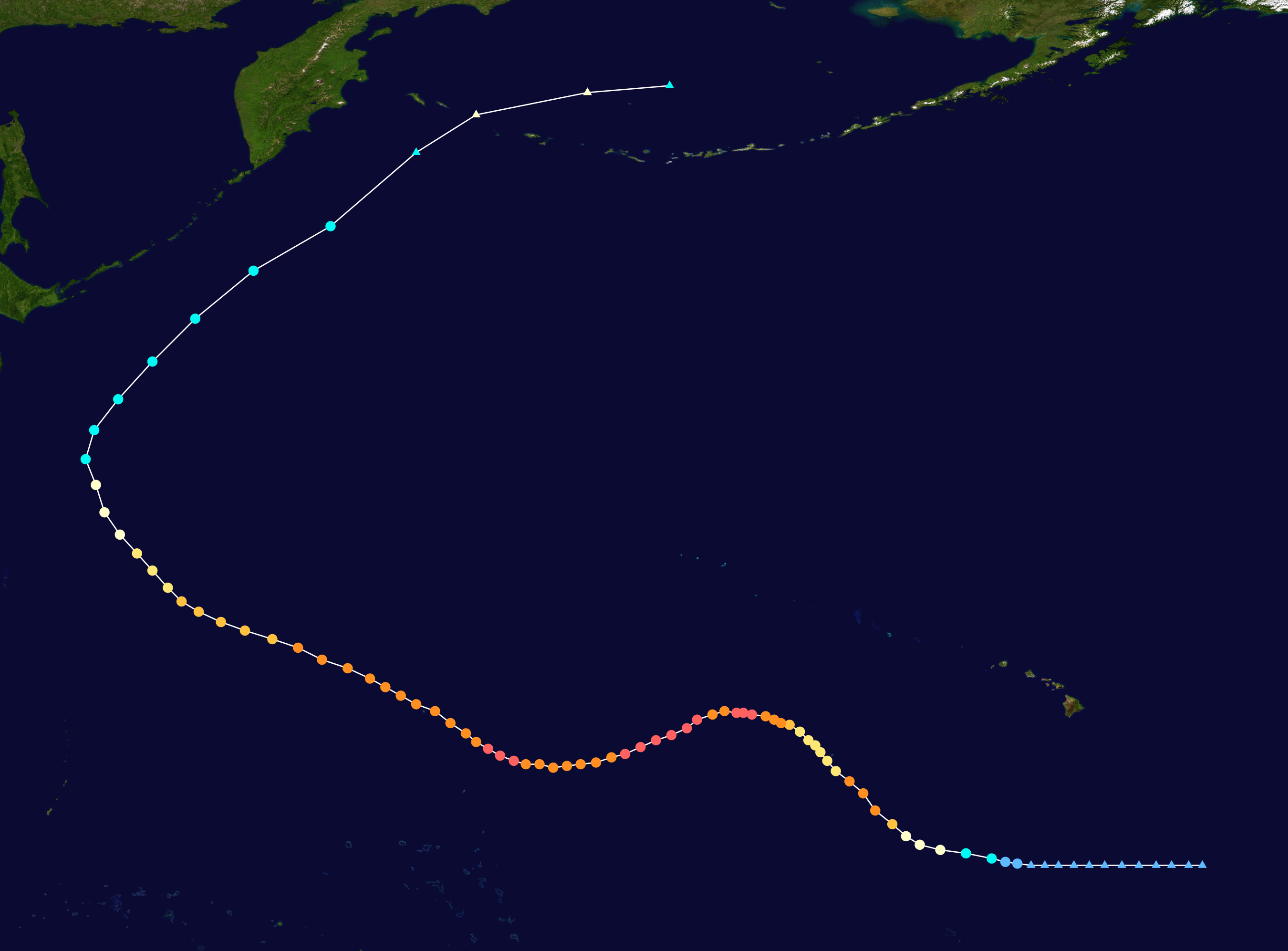
Here's an example of a extratropical storm in the bearing sea...the left overs from Typhoon loke.

Image
Image
0 likes   

PhillyWX
Category 1
Category 1
Posts: 494
Joined: Tue Aug 30, 2005 8:54 am
Location: Philly
Contact:

#16 Postby PhillyWX » Sun Sep 16, 2007 10:23 am

MCorder, how deep did Ioke get once declared post-tropical?
0 likes   

User avatar
MCorder
Professional-Met
Professional-Met
Posts: 42
Joined: Wed Aug 02, 2006 4:58 pm
Location: Kodiak Alaska
Contact:

Re: First Big Winter Low

#17 Postby MCorder » Mon Sep 17, 2007 12:33 am

Philly, I'm not sure...I'll have to check my data at work.
Just glanced at the Sats and noticed another example of a tropical system feeding our lows. The one over the central chain is forecasted to drop to 960mb. You can see it sucking moisture from the system near Japan.
Image Image

MCorder
Kodiak Alaksa :cold:
0 likes   

PhillyWX
Category 1
Category 1
Posts: 494
Joined: Tue Aug 30, 2005 8:54 am
Location: Philly
Contact:

#18 Postby PhillyWX » Mon Sep 17, 2007 7:16 am

Impressive satellite presentation!
0 likes   

User avatar
MCorder
Professional-Met
Professional-Met
Posts: 42
Joined: Wed Aug 02, 2006 4:58 pm
Location: Kodiak Alaska
Contact:

Re: First Big Winter Low

#19 Postby MCorder » Mon Sep 17, 2007 10:59 am

Just a follow up, looks like the 06Z surface had us at 960mb...
Winds throughout the chain for today 40 - 60kts (46-69mph)
Looks like the moisture from the TS is pretty much gone from Japan, there doesn't seem to be any jet support from the tropics...960 might be as low as this one gets. It does look to be wrapping up nicely though.
Image

Image Image Image

MCorder
Kodiak Alaska :cold:
0 likes   

User avatar
MCorder
Professional-Met
Professional-Met
Posts: 42
Joined: Wed Aug 02, 2006 4:58 pm
Location: Kodiak Alaska
Contact:

Re: First Big Winter Low

#20 Postby MCorder » Mon Sep 17, 2007 6:06 pm

Guess I was wrong...latest surface has it down to 958!

Image

Image
0 likes   


Return to “Winter Weather”

Who is online

Users browsing this forum: No registered users and 10 guests