 The posts in this forum are NOT official forecast and should not be used as such. They are just the opinion of the poster and may or may not be backed by sound meteorological data. They are NOT endorsed by any professional institution or
Overview
After an initial February and early March with temperatures well below average across portions of the Mid-Atlantic, Northeast, and Great Lakes regions, March should feature a moderation trend. Although ensembles have periodically progged periods of 500 millibars blocking (-AO and -NAO) over Greenland and an upcoming warmer trend (high +AO and +NAO departures) neither negative nor positive biases appear to be verifying nor are supported by the synoptic pattern. Despite some current stratospheric warming I don't believe this will have an adverse affect on the subsequent longwave pattern to deliver sustained cold to the northeastern CONUS; however, the strengthening MJO (nearing the eighth phase if it continues it's current pace) may affect the 500 millibars configuration in the eastern North Pacific near the end of the month and potentially aid in a +PNA configuration and upper-level ridging near western Canada. This may aid in some cooler air transport to the east-central CONUS but with the generally stable trends this winter I don't expect warmer conditions to be permanently halted even with the potential (but possibly mild and likely brief) periodic reemergence of a -AO or -NAO. I expect the AO and NAO to average near neutral through the rest of the month (with some occasional mild negative and positive departures). With the configuration of subsurface and SST trends in the North Pacific and South Pacific (slowly emerging -PDO and +NOI signal) aiding in the development of a possible La Nina and with mean westerly and southerly flow over the deep Southeast and Florida I expect the surface heat ridging near the Bahamas and Florida to potentially reemerge further down the road. I also expect the development of a weak and broad trough over the Pacific Northwest and interior southwest Canada east to Idaho over the next several weeks in tandem with other factors. Some good analogs include 3/19/1968, 3/21/1993, 3/16/98, 3/26/01, and 3/16/04 with regards to the pattern evolution over the next few weeks at the 500 millibars level. This image is based on the aforementioned analogs.
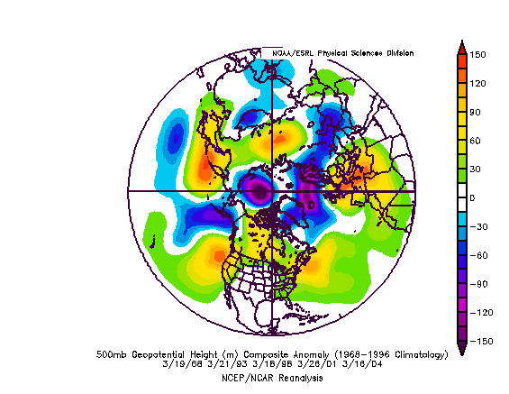
This graphic could reflect the overall mean anomalies towards the end of March. Although I don't expect a robust 500 millibars ridging anomaly off the Eastern Seaboard, some similarities exist for these dates in regards to some aspects of the progression of the pattern. Note the trough near the Aleutians. As the month progresses, we should see troughing shift east into the Pacific Northwest with upper-level ridging displaced futher southwest off northwest California. In addition, note the absence of any strong negative (blocking) signal (or positive troughing signal) in the AO or NAO through most of the period.
Here is a signature of the potential pattern progression (as evidenced over the course of the next few images). These are based on the analogs of 3/21/1964, 3/29/1968, 3/27/1998, and 3/16/2004.
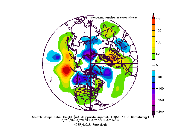
Overall synoptics support the emergence of a mild positive anomaly near the Azores. The Pacific and other factors relay into the emerging Pacific Northwest trough. Mild positive anomalies (ridging) develops over the southern portions of the CONUS and Great Plains. The AO and NAO fluctuates but remains generally near neutral status.
The next graphic indicates the same analogs but moves each date forward by one day.
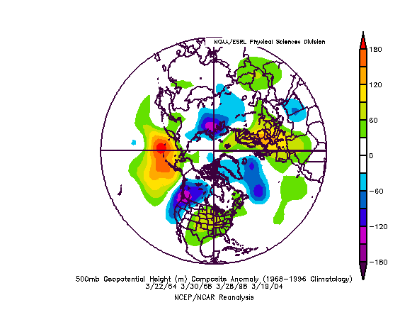
The positive anomalies over the southern CONUS shift east-southeast. Generally cool conditions remain over the northeastern CONUS but cold air transport slowly moderates. Some periodic very cold air invasions continue but slowly subside. The Pacific Northwest trough becomes well developed. Synoptics relay and develop a positive ridging anomaly near the Aleutians and southeast of northeast Russia.
Here is another graphic showing the progression another day ahead.
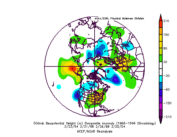
The Pacific Northwest trough splits and moves south-southwest. The Aleutians positive anomaly remains well defined and concentrated. AO and NAO fluctuate between slight negative and positive departures. A warming trend may take place over the Southeast and portions of the Mid-Atlantic as trends progress. Troughing remains in place over northwest Canada but cold air transport wanes due to persistent zonal flow further south over the northern portions of the CONUS.
Summary
Here is my March 2007 temperature outlook.
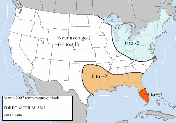
I expect the greatest positive average departures for the month (as a whole) to occur in the Southeast and the southern half of the Florida peninsula. I expect negative departures to continue over the Northeast and Mid-Atlantic but I believe those departures will moderate by the end of the month, leading to averages slightly below normal for the month of March. I expect the greater expanse of the rest of the CONUS through the western United States to average near normal for the month.