Modifications to 1st call --- and thoughts on the late week:

Winter Weather Discussion

Moderator: S2k Moderators

Forum rules

The posts in this forum are NOT official forecast and should not be used as such. They are just the opinion of the poster and may or may not be backed by sound meteorological data. They are NOT endorsed by any professional institution or STORM2K.

Help Support Storm2K
Message
Author
User avatar
FLguy
Professional-Met
Professional-Met
Posts: 799
Joined: Mon Dec 29, 2003 5:36 pm
Location: Daytona Beach FL
Contact:

Modifications to 1st call --- and thoughts on the late week:

#1 Postby FLguy » Mon Feb 02, 2004 3:16 am

some modifications to snow amounts ---- i am bringing down the total snow amounts in the 4-8" and 8-12" areas previously outlined in my last post.

the updated info goes like this:

2" or more (2-4") --- on the eastern side; Blacksburg VA, northeast to Allentown PA, Springfield MA, Gloucester MA, and out. On the western side, Blacksburg VA, to Pineville WV, then take that directly north to Cleveland.

4 Inches or more (4-8" area) --- on the eastern side, Union WV, northeast to Harrisburg PA, Pittsfield MA, Portland ME, and out. On the western side, Union WV to Johnstown PA, then northeast to Rochester NY. Local totals up to 10" cant be ruled out.

this WILL be a big ticket icing event in areas where the depth of the warm layer is such that p-type is predominantly ZRA (warm enough aloft for liquid, with a sub-freezing boundary layer). MDT, SEG, AVP, MPO, ABE, BGM LOOK OUT!!

significant ice accumulations on trees and power lines COULD result in outages across the piedmont areas from MD up through PA, and into southern new england.

overall i prefer the GFS solution over the ETA, but we will review both as the ETA does a better job with convective instability. that said the GFS generates QPFs of .50-.75" over a wide area of the interior MD/PA/NY/CT.

Image

the big sticking point with this system is its fast movement. which will help to limit total QPF, and hence preclude what otherwise may have been a MAJOR ice and snow event for the interior Mid atlantic, northeast and new england. but even with this in mind, significant ice and snow is likely.

the ETA still implies good convective instability across much of the northern mid-atlantic. the 0z ETA sounding at ABE revealed strong elevated CAPE (generally less than 50 J/kg, however when dealing with CSI, it can be an important feature). as the strongest UVM moves over eastern PA/NJ and NYC between 42 and 48hrs as the trough tilts negative.

Image

Image

LR 5-7 are mostly dry adiabatic, generally between 6.50 and 7.00 C/km. and convective temps are reached.

KABE (allentown, PA) sounding:

http://weather.admin.niu.edu/chaser/tempgif/29280.TXT

Image

KMPO (MT pocono PA) sounding:

http://weather.admin.niu.edu/chaser/tempgif/30237.TXT

Image

KAVP (scranton/wilkes-barre PA) sounding:

http://weather.admin.niu.edu/chaser/tempgif/30306.TXT

Image

the problems become even BIGGER once one gets into the AVP-BGM corridor. in this area, soundings show a near to ever so slightly above freezing layer below 800mb (evident mostly on the AVP sounding), thus im concerned that given the strong CI and CSI signals combined with this type of thermal profile that these areas will be back and forth between +SN/IP/ZRA. and im also concerned that P-type is mostly snow while the strongest UVM is overhead. thus somebody will probably pick up 8"+ especially across the higher elevations of the FAR northeastern poconos (central and northern wayne county for those that are familiar w/ NE PA)

now late week system --- im not going to worry about the specifics of the model output, since were 5 days out, making those aspects of the system irrelevant at this time (such as the track of SFC low, Ptype, QPF and so on).

tonights 0z GFS DOES attempt to take the irst system, close it off, and make it the new 50/50 low by 096hrs:

Image

this (as i have said many times) forces the PJ wavelengths to sharpen, resulting in blocking over the top and therefore, a -NAO.

what therefore is most likely to happen is the s/w energy across the MS valley is going to be forced to take a more southern track, creating a colder and snowier solution for the Mid-atlantic and Northeast.

so even as the ridge pops up in western europe, which the ensembles illustrated quite well:

Image

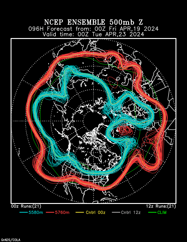
the teleconnection between that ridge and the ridge off the SE coast of the US is mitigated somewhat by the 50/50 low. and any blocking that might also try to develop. so, no, there WILL NOT be any major flood in the northeast this weekend.

overall IMO the event still has potential.
0 likes   

User avatar
FLguy
Professional-Met
Professional-Met
Posts: 799
Joined: Mon Dec 29, 2003 5:36 pm
Location: Daytona Beach FL
Contact:

#2 Postby FLguy » Mon Feb 02, 2004 4:18 am

furthermore, as i previously neglected to indicate, SN/liquid ratios will be pathetic across much of the region. so in areas where it does snow, expect a perhaps 7:1 or 8:1 ratio given marginal temps and high thicknesses.

examination of BUFKIT soundings revealed a very high dendritic layer (~15K ft) with most of the best UVM below it. this is NOT favorable for heavy accumulations.
0 likes   

User avatar
Lowpressure
S2K Supporter
S2K Supporter
Posts: 2032
Age: 58
Joined: Sun Sep 14, 2003 9:17 am
Location: Charlotte, North Carolina

#3 Postby Lowpressure » Mon Feb 02, 2004 7:24 am

Great analysis - as usual. Thanks for the hard work.
0 likes   

User avatar
JCT777
Category 5
Category 5
Posts: 6251
Joined: Mon Oct 14, 2002 9:21 am
Location: Spring Mount, PA
Contact:

#4 Postby JCT777 » Mon Feb 02, 2004 9:56 am

Good update, FLguy. These snow amounts sound very reasonable. My area is expected to get about an inch or two of snow tomorrow morning, before changing to a period of ice and then rain. The late week event still has some good potential to be a significant winter storm.
0 likes   

User avatar
Lowpressure
S2K Supporter
S2K Supporter
Posts: 2032
Age: 58
Joined: Sun Sep 14, 2003 9:17 am
Location: Charlotte, North Carolina

#5 Postby Lowpressure » Mon Feb 02, 2004 11:17 am

Agree with the lower snowfall totals. Looks to be a good deal of ice. D.C calling for 1/4 or greater of ice. Snow on the onset and at the finish as storm moves out.
0 likes   

donsutherland1
S2K Analyst
S2K Analyst
Posts: 2718
Joined: Mon Sep 15, 2003 8:49 pm
Location: New York

Re: Modifications to 1st call --- and thoughts on the late w

#6 Postby donsutherland1 » Mon Feb 02, 2004 11:44 am

Great discussion, FLguy. I also agree with the late week/weekend event that one should not write it off just yet given some of the factors you pointed to e.g., the possible development of a 50-50 low prior to the event.
0 likes   

Anonymous

#7 Postby Anonymous » Mon Feb 02, 2004 12:22 pm

I'm looking forward to my ice! :)

I love the way the sun glints off it. Also I've been enjoying icewalks during my jebwalks at Potomac Mills and I have not fallen once. I think you can consider me a professional jebwalker. They have parts of the Potomac Mills parking lot unplowed, folks drive on these areas and packed the snow down, then the ice got on it and it's a fantastic place to jebwalk!!!! One such place is about 900 yards wide, that I have dubbed "The Gulag". You have to pay close attention while you cross the Gulag portion of the Potomac Mills jebwalk because of major ice issues and slabs of snow and runoff areas that have frozen!! I LOVE trying to jebwalk across that Gulag!!!

Tonight and tomorrow, more freezing rain is on tap, into tomorrow!!

I can hardly wait to walk on all the new ice!!! Man that is gonna be a CHALLENGE!!! That is one heck of an Ice Gulag!!!!


I should be happily starting my storm thread sometime today! :)

BRING THAT ICE!!!! :) :)


-JEB!!!!!!!!
0 likes   

User avatar
Lowpressure
S2K Supporter
S2K Supporter
Posts: 2032
Age: 58
Joined: Sun Sep 14, 2003 9:17 am
Location: Charlotte, North Carolina

#8 Postby Lowpressure » Mon Feb 02, 2004 2:29 pm

In that parking lot at night you have more than ice to worry about.
0 likes   

User avatar
Chris the Weather Man
Category 2
Category 2
Posts: 746
Joined: Fri Dec 12, 2003 9:49 pm
Location: NJ

#9 Postby Chris the Weather Man » Mon Feb 02, 2004 4:08 pm

Yes, Great Analysis! But, I would love to see another blizzard of 1983!
0 likes   

weatherfan
Tropical Depression
Tropical Depression
Posts: 89
Joined: Wed Dec 17, 2003 7:50 pm

#10 Postby weatherfan » Tue Feb 03, 2004 6:50 pm

FLguy I don't know if you seen the Alantic ssts in the last few weeks.but wow what a turn arund from the first part of the winter.It has really cooled down.Its a classest signel look for predomantey Negative NAO favering.So who ever thinks we are lock for a postive NAO is likey going to be wrong giving the Alantic profiles now.I agree that the NAO may go postive for a bife time but as you said Flguy it would only be for a sort time and back to negative again.So still there is pleanty of possableys in this pattern.But again of couse as we have seen time and time after time again it seems.Nothing really ever comes togeather correcy for big phaseing events this winter.So there is no Garrentees.
0 likes   


Return to “Winter Weather”

Who is online

Users browsing this forum: No registered users and 4 guests