 The posts in this forum are NOT official forecast and should not be used as such. They are just the opinion of the poster and may or may not be backed by sound meteorological data. They are NOT endorsed by any professional institution or

As some of you may be aware…I did a similar post concerning the connection between various phases of the ENSO (El Nino Southern oscillation), SOI (Southern Oscillation Index), NAO (North Atlantic oscillation), and MEI (Multi-relative ENSO index)…on Wright-weather bulletin board back on October 15. I felt that it would also be rather interesting to post this here as IMO many could benefit from knowing which particular phases and values of those factors would indicate in regard to the potential (or lack thereof) for a major east coast snow event.
First however, we must assess the state of the ENSO. In our winter outlook released here back on November 20th:
http://www.storm2k.org/phpbb2/viewtopic.php?t=19199
And in a similar post a few days ago on the evolution toward El Nino conditions:
http://www.storm2k.org/phpbb2/viewtopic.php?t=19552
Erica and I outlined the fact that the general trending of the equatorial Pacific Sea Surface temperature anomalies during the past few months, and the current long-range SSTA forecasts from several well-known climate models, support the development of weak El Nino conditions by the end of December, and moderate El Nino conditions by as early as late spring (May 2004). While the potential formation of a moderate warm ENSO event is possible by spring, that feature would have more importance to the expected outcome of the 2004 hurricane season; it is the weak El Nino which should be present by the end of next month, which may help to determine the outcome of the 2003/04 winter (snow-wise) for much of the central and eastern part of the country.
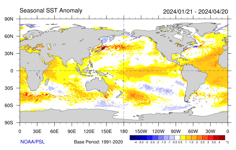
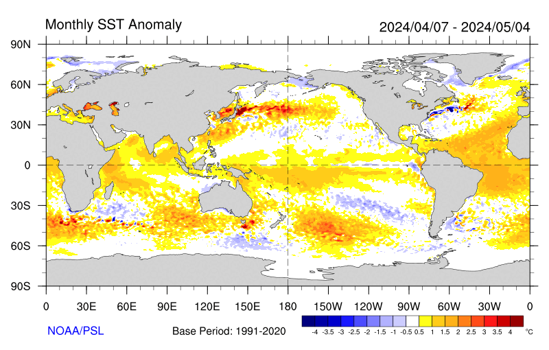
The following figures show SSTA Evolution in weekly, monthly and seasonal time steps (from the CDC):
Seasonal product:
http://www.cdc.noaa.gov/map/images/sst/ ... asonal.gif
Monthly product:
http://www.cdc.noaa.gov/map/images/sst/ ... .month.gif
Weekly product:
http://www.cdc.noaa.gov/map/images/sst/sst.anom.gif
Pronounced warming continues to take place along and just to the west of the dateline as SSTs in the region are now approaching 1.5 degrees Celsius above normal, and in the Nino 3.4 region of the central tropical pacific. Should this persist and expand during the month of December, El Nino conditions will be recognized by the end of the month. Remember, El Nino conditions are officially declared by NOAA when SSTA anomalies sin the Nino 3.4 region average above normal for at least three months.
The values below illustrate weekly SSTA anomalies in textual format over the past 12 weeks:
(Column 1 = Start Date…Column 2 = Nino 1+2 SST mean/SST anomaly…Column 3 = Nino 3.0 SST mean/SST anomaly…Column 4 = Nino 3.4 SST mean/SST anomaly… Column 2 = Nino 4.0 SST mean/SST anomaly)
03SEP2003 20.4 -.3 25.0 .1 26.9 .2 29.0 .5
10SEP2003 19.9 -.7 24.8 -.1 26.8 .1 28.9 .4
17SEP2003 19.5-1.0 25.0 .1 26.9 .2 28.9 .5
24SEP2003 20.5 -.2 25.0 .2 27.1 .5 29.1 .7
01OCT2003 20.1 -.7 25.3 .4 27.3 .6 29.1 .7
08OCT2003 20.9 .1 25.5 .6 27.4 .8 29.1 .7
15OCT2003 20.9 .0 25.2 .3 27.1 .5 29.1 .7
22OCT2003 21.5 .5 25.3 .3 27.1 .5 29.3 .9
29OCT2003 21.4 .2 25.4 .5 27.2 .6 29.3 1.0
05NOV2003 21.6 .2 25.3 .4 27.0 .5 29.4 1.0
12NOV2003 21.8 .3 25.3 .4 26.9 .4 29.3 1.0
19NOV2003 22.0 .2 25.4 .5 27.1 .5 29.3 1.0
As we can tell…the greatest warming relative to normal has taken place in the Nino 4.0 region over the past several weeks…however…we have began to notice a pronounced warming of the SSTA in the remainder of the ENSO regions (1+2, 3.0, and 3.4). At the present time…all four Nino regions have been averaging warmer than normal, with the greatest departures above normal in the western pacific with SSTA now running (according to the weekly averages over the past four weeks) as high as 1.0 degrees above normal. Although, that said, some day to day fluctuations in the exact SSTA values in these regions can yield a lower or higher value than what is being observed in the weekly mean. This is especially the case when we look at the latest SSTA map from the CDC…which has been indicating SSTA of up to 1.5 degrees in the Nino 4.0 region during the past week.
FTP access to weekly and monthly SST/SSTA analysis data-sets from the CPC:
Weekly Analysis (1990-present):
ftp://ftpprd.ncep.noaa.gov/pub/cpc/wd52 ... /wksst.for
Monthly Analysis (text – 1950 to present):
ftp://ftpprd.ncep.noaa.gov/pub/cpc/wd52 ... oi.indices
Graphical depiction (1984 to present):

The majority of climate models also support the evolution to El Nino conditions during the first half of 2004.
NCEP Model:
Three Month mean:

Monthly SSTA forecast:

Monthly Sub-surface temperature anomaly forecast:
http://www.emc.ncep.noaa.gov/research/c ... EQTvrt.gif
And many of the ensembles:
Nino 3.0 SSTA forecast:

Nino 3.4 SSTA forecast:

The majority of the warming based on the implications of the model forecast would take place in the central and western pacific (Nino regions 3.4 and 4.0…which is a favorable signal for a cold/snowy winter in the eastern part of the country)
FTP access to SSTA forecasts:
ftp://ftp.ncep.noaa.gov/pub/cmb/Forecasts/enso
The SCRIPPS forecast by far remains the most bullish on the evolution to warm conditions:
http://meteora.ucsd.edu/~pierce/elnino/pictures.html
My take on the subject remains unchanged…which would be for ENSO neutral (although slightly warm Neutral conditions) to persist through the remainder of the month, and eventually begin to translate to weak El Nino from west to east (however the warmest anomalies early on should remain confined to the areas closest to the dateline and in the western portions of the Nino 4.0 region through march) while near average conditions remain intact in the eastern pacific closest to the coast of south America.
As we get out toward the end of the winter…further inquiry will be needed to determine whether or not a moderate El Nino will develop during this time period and what impacts it might have on the coming hurricane season.
Other factors such as the SOI and MEI are dictated by the observed phase of the ENSO. That said, if La Nina conditions are present would likely see a Positive SOI, and an MEI ranking of between 1 and 3, MEI rankings of three would indicate a weak La Nina event, two…moderate La Nina…and one…strong La Nina. An MEI ranking of 4 is indicative of ENSO neutral conditions, then five through seven would denote El Nino Conditions, with 5 outlining a weak El Nino…6 Moderate El Nino…and 7 Strong El Nino. The SOI is normally negative in El Nino years, while a variable SOI. For a detailed description of these features, consult our winter outlook.
We expect…based on the current trending in Atlantic Sea Surface temperature anomalies, that we will be dealing with a neutral to negative NAO this coming winter. Cold water has developed across the north central Atlantic between the east coast of Newfoundland, and the west coast of Europe, with warmer than average SSTA in the far north Atlantic, and tropical Atlantic, the theory behind this is that storm systems will be encouraged to deepen off the east coast and move northward, then eastward across the Atlantic as compared to deepening straight up toward Greenland, helping to pump heat northward, raise heights, and develop blocking.
Research in recent years has shown a distinct correlation between the Nino 3.4 SSTs and the frequency of major east coast snowstorms, connections between these events, the SOI, MEI (Multi-relative ENSO Index) and NAO have also been drawn up. I will also be including a rather interesting connection between the monthly QBO index values and the frequency of such events.
The following are a listing of major east coast snowstorms as determined by Paul Kocin and Dr. Louis Ucceleini in a publication through the American meteorological society:
MAR 18-19, 1956 FEB 14-17, 1958
MAR 18-21, 1958 MAR 2-5, 1960
DEC 11-13, 1960 JAN 18-21, 1961
FEB 2-5, 1961 JAN 11-14, 1964
JAN 29-31, 1966 DEC 23-25, 1966
FEB 5-7, 1967 FEB 8-10, 1969
FEB 25-28, 1969 DEC 25-28, 1969
FEB 18-20, 1972 JAN 19-21, 1978
FEB 5-7, 1978 FEB 17- 19, 1979
APR 6-7, 1982 FEB 10-12, 1983
JAN 21-23, 1987 JAN 25-27, 1987
FEB 22-24, 1987 MAR 12-14, 1993
FEB 8-12, 1994 FEB 2-4, 1995
JAN 6-8, 1996 MAR 31-APR 1, 1997
Of the events listed above, 16 out of the 28 events occurred with an El Nino of some strength in the Equatorial pacific. 9 of 28 occurred with ENSO neutral conditions, and only three of the 28 occurred w/ a La Nina of any strength.
Out of those events occurring with an El Nino:
4/16 – w/ a Weak El Nino (MEI ranking 4 to 5)
6/16 – w/ a Weak to Moderate El Nino (MEI ranking 5 to 6)
6/16 – w/ a Moderate to Strong El Nino (MEI ranking greater than 6)
It would appear as if a greater frequency of major east coast snowstorms is maximized in El Nino years, with an even number of events (6 events) occurring with both a weak to moderate and moderate to strong El Nino/s.
La Nina conditions:
2/3 w/ a Weak La Nina (MEI ranking 3)
0/3 w/ a Moderate La Nina (MEI ranking 2)
1/3 w/ a Strong La Nina (MEI ranking 1)
While the most total events occur in El Nino years, 9 of the storms occurred in ENSO neutral winters, once one divides the El Nino events up according to the strength of the El Nino we find that less total events (6 events in Weak to moderate and moderate to strong El Nino years) occur as compared to the 9 total which occur in ENSO neutral winters.
Nino 3.4 SSTs:
Nino 3.4 SSTa -0.5 to -1.0 -----> 2 events
Nino 3.4 SSTa -0.5 to 0.0 -----> 5 events
Nino 3.4 SSTa 0.0 to +0.5 -----> 4 events
Nino 3.4 SSTa +0.5 to +1.0 -----> 4 events
Nino 3.4 SSTa +1.0 to +1.5 -----> 6 events
Nino 3.4 SSTa +1.5 to +2.0 -----> 2 events
Nino 3.4 SSTa +2.0 to +2.5 -----> 0 events
Nino 3.4 SSTa +2.5 to +3.0 -----> 1 event
It would appear as if the greatest number of events occur in periods where Nino 3.4 SST anomalies are between +1.0 and +1.5 degrees above normal. A less (however still comparable) number of events occur with SST anomalies between -0.5 to 0.0, 0.0 to +0.5, and +1.0 to +1.5.
Now for the SOI:
SOI +1.5 to +2.0 ---> 1 event
SOI +1.0 to +1.5 ---> 0 events
SOI +0.5 to +1.0 ---> 5 events
SOI +0.0 to +0.5 ---> 1 event
SOI –0.0 to –0.5 ---> 6 events
SOI –0.5 to –1.0 ---> 6 events
SOI –1.0 to –1.5 ---> 3 events
SOI –1.5 to –2.0 ---> 2 events
SOI –2.0 to –2.5 ---> 0 events
SOI –2.5 to –3.0 ---> 0 events
SOI –3.0 to –3.5 ---> 0 events
SOI –3.5 to –4.0 ---> 1 event
SOI –4.0 to –4.5 ---> 0 events
SOI –4.5 to –5.0 ---> 1 event
For the data above, one can surmise that the best probability for a major east coast snow event based on the SOI would be maximized in periods where the SOI is between 0.0
To -1.0. 12 total events occurred when the SOI was in that range. The other events which occurred in periods when the SOI was strongly negative…between -3.5 to -4.0 and -4.5 to -5.0 would most likely denote isolated cases.
The NAO comparison:
Another possible influencing factor on the formation of major east coast snowstorms may also be the North Atlantic Oscillation.
17 of the 28 events occurred with a negative monthly averaged NAO, as compared to 11 of 28 with a positive monthly averaged NAO.
The QBO connection:
It would seem as if the greatest frequency of major east coast snowstorms based on the observed monthly phase of the QBO would occur in months where the QBO is between +/- 10.00 of neutral (0.00), however, when QBO values were greater than +10.00 (strong west) far more events occurred as compared to when the QBO was Strong east (-10.00 or better), thus feature the least potential (statistically) for a major east coast snow event, however that is not to say that it still can/t happen.
QBO weak East or West (between +/- 10.00): Greatest overall Potential
QBO Strongly west (greater than +10.00): Second greatest Potential
QBO Strongly east (greater than -10.00): Least Potential.
A link to the QBO dataset is provided below:
http://www.cdc.noaa.gov/correlation/qbo.data
Given this assessment, one would expect to see a major east coast snow event when ENSO neutral to Moderate El Nino conditions exist in the tropical pacific, an MEI ranking at or above 4, negative NAO, Nino 3.4 SST anomalies between +1.0 and +1.5 degrees above normal, and a negative SOI between 0.0 and -1.0. QBO near neutral QBO values are also preferred.


