The posts in this forum are NOT official forecast and should not be used as such. They are just the opinion of the poster and may or may not be backed by sound meteorological data. They are NOT endorsed by any professional institution or

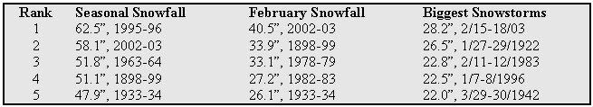
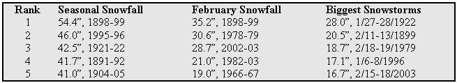
By the time the last snowflakes stop falling late Saturday or possibly early Sunday, Winter 2009-10 should be among the 5 snowiest winters on record in both Baltimore and Washington, D.C. Moreover, monthly snowfall in Washington, D.C. should be among the 5 highest figures for February. In Baltimore, monthly snowfall could be near or among the 5 highest figures for February.
Baltimore:
February snowfall through 2/4: 4.9”
Seasonal snowfall through 2/4: 35.6”
Washington, D.C. (DCA):
February snowfall through 2/4: 3.3”
Seasonal snowfall through 2/4: 27.3”
It should be noted that even as the 2/5 0z NAM came in notably drier from Philadelphia north and eastward, I have only trimmed amounts in those areas. SREF guidance and the GFS's continuity suggest that the NAM might be overdoing the magnitude of the gradient.
At this point in time, my estimates for the February 5-6, 2010 Snowstorm:
Allentown: 4”-8”
Baltimore: 16”-24”
Hagerstown: 12”-24”
Harrisburg: 6”-12”
New York City: 3”-6”
Newark: 4”-8”
Philadelphia: 10”-15”
Richmond: 4”-8”
Washington, D.C.:
…DCA: 16”-24”
…IAD: 16”-24”
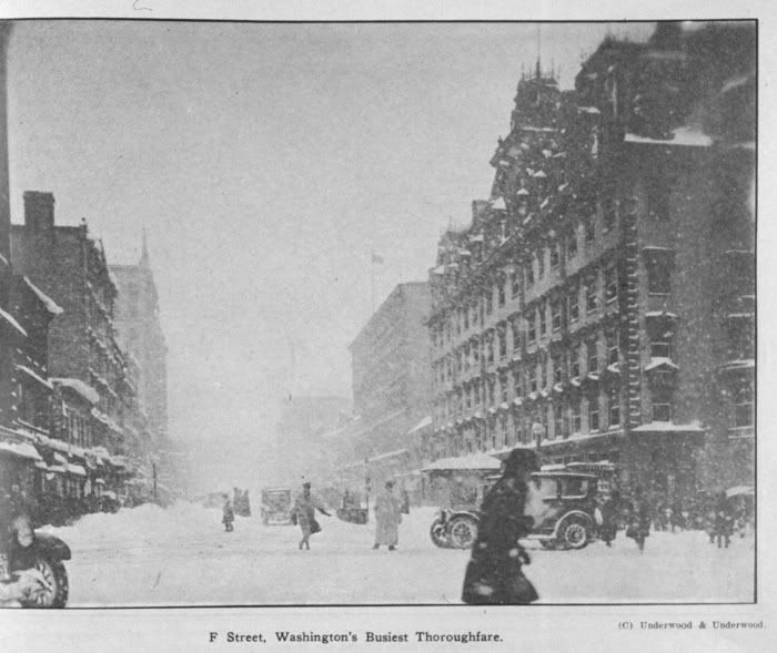
Knickerbocker Snowstorm (NOAA Photo Library)
From the news caption on the January 29, 1922 edition of The Washington Post:
Washington center of driving blizzard that sweeps Virginia, Maryland, and Delaware—Snowfall exceeds all records…Capital paralyzed under deep blanket of white.
Streetcars and automobiles jammed in snowbound streets—population tied up in homes—Armament conference meetings halted—Congress activities practically suspended…
Disclaimer:
The following post is NOT an official forecast and should not be used as such. It is just the opinion of the poster and may or may not be backed by sound meteorological data. It is NOT endorsed by any professional institution including storm2k.org. For official information, please refer to NWS products.