The thread is taking a turn off topic, but it is still interesting conversation so…..
One thing I dont quite understand Scott so help me...If the Rockies block cold polar highs from getting west of the mountains...why the constantly frigid temps in Craig compared to SLC. They are both valley locals west of the Divide at similar latitudes so I would expect similar temps but they couldnt be more different.
I'm not sure if it makes much difference, but Craig is about 2000 feet higher than SLC.
I guess there are several reasons, but I can’t say I know all of them. Elevation does make a difference, but not enough to compensate the huge temperature differences between SLC and Craig. Craig is at 6300 feet, Denver is at 5300 feet and Salt Lake is at about 4300 feet, but check out the temperature differences between them all (on a different note, as mentioned earlier see that the temperature in SLC is more stable than Denver both on the high and low sides):


1. In Craig, there is no Great Salt Lake which definitely moderates the temperature in SLC. As mentioned, away from the Great Salt Lake, temperatures in NW Utah are colder at night than they are near the lake. Fairfield is not far SW of SLC, but is blocked from the lake by a narrow range of mountains. It’s about the same elevation, but is quite a bit cooler at night:
http://www.wrcc.dri.edu/cgi-bin/cliMAIN.pl?ut2696Areas not downwind from the lake are also drier.
2. More of the air masses definitely reach Craig than they do SLC. It is true that Craig is west of the divide, but just north of here and in Wyoming the Continental Divide is actually in the plains rather than in the mountains. There is a big gap in the Rockies for over 100 miles and many of the cold air masses that reach Denver also spill through the gap and reach Craig. Cold does spill over the divide, but to reach SLC it has to cross over the Wasatch Mountains (and other ranges) as well. The plateaus and valleys east of the Wasatch are much colder in winter than the ones west of the mountains.
3. Craig is also subject to strong inversions and they are much more severe than the ones around SLC. We don’t get the fog or the pollution, but the temperature inversions can be fierce and last a long time. Sometimes it is 30-40 degrees warmer at 10,000 feet than it is down here at 6300 feet. Yesterday, for example I had -24F at the house and it was officially -21F in downtown Craig. At the same time, the weather report said it was +7F up on Mount Werner at 10,565 feet, which is a difference of 31 degrees. SLC also has inversions, but usually not to the same extent.
This is evident in the local weather stations as well. The Craig/Moffat weather station (which is where all these reports in this thread are from) is at the SE side of town. Temperatures there have dropped to -56F. The Craig 4SW station is about seven miles southwest of town and at the Trapper Mine which sits on a hill. It’s much warmer there at night and has never seen a temperature colder than -41F. The same day (Feb 1 1985) that it was -41F at the Craig 4SW station, at Maybell the next tiny town to the west of Craig it was -61F. Maybell sits at 5920 feet and the station is close to the river. The -61F remains the coldest temperature ever recorded in Colorado, even though the elevation is not much higher than Denver. At the CDOT building in Craig, also low down and near the river, coworkers claim they recorded a -64F the same day.
Like SLC, the air in Craig can really stagnate and usually at night there isn’t any wind drainage which also causes radiative cooling.
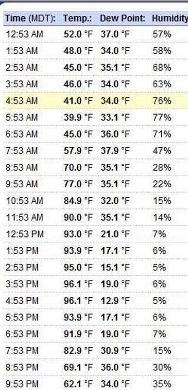
4. Especially on clear nights, Craig also has much greater diurnal temperature changes between day and night than SLC does. You can see this in the above report as well, but it’s even greater in summer. Check out the report below as an example (this is a good one to use since you can also see the difference between cloudy and clear nights: July 5 was cloudy, though nights that warm are still very rare):

Notice that it can be almost as hot in Craig during the day as it can be in Denver or SLC. At night though, the temperatures are much cooler. Here is the hourly report from July 2 in the report above. Check out just how much (and fast) the temperature skyrockets when the sun comes up and how it drops like a rock as soon as the sun goes down:
Night temperatures can be very cold here, especially in winter, but on the plus side it does warm up during the day.
I guess these are the main reasons why I can think that Craig would be that much colder than SLC, but there are probably more.
Anyway, even though Maybell has the record low in Colorado, some places are colder on average due to some of the same reasons above. Places like Gunnison and Fraser are colder on average than Craig and Maybell are.
My image of SLC was that it was just generally warmer and drier than Denver...but the reality is that avg temps and precip for the 2 cities arent much different
Yes, it is amazing both how similar and different the climates of the two places are.
Salt Lake City has an annual temperature of 52.1F which is very close to Denver’s 50.7F (Salt Lake is lower elevation and slightly farther north). Salt Lake Airport averages 15.65 inches of precip a year; Denver 15.43, which is almost identical. Snowfall is almost identical as well with 60.1 for Salt Lake and 58.9 for Denver. The record low in both Salt Lake City and Denver is -30F. The record high in Salt Lake is 107 vs Denver’s 105, but they are both fairly close.
...however some notable differences are that :
1) SLC has less extremes in winter temps than Denver, but seems to have more extremes in summer temps, and vise versa...100's happen yearly in SLC but only every few years in Denver.
What’s weird is that the July-August extremes on the cold side are also cooler in Salt Lake. In Salt Lake, it has dropped into the 30’s several times in August and down to 40 in July, something Denver has never done. Lower humidity in summer perhaps? Just a guess; I have no idea. Outside July and August, Denver has more extremes in all other months.
2) In terms of snowfall SLC gets more of theirs in winter, than Denver...Denvers snowiest months are March and November...SLC is the opposite with Decemeber and January being its snowiest months...You would tend to think SLC comes closer to supporting snow cover for much of winter, but my understanding is that much like Denver, it doesnt.
There are some other differences as well. In Salt Lake severe thunderstorms are extremely rare. Hailstorms are tornadoes are also very rare (only two people have been killed by tornadoes in the entire state of Utah any time in the last 162 years), though one tornado did rip through downtown some years ago. The biggest hailstone I have seen in Salt Lake was about an inch and a half in diameter, but even this is rare.
One reason Denver has warm temperatures is because of Chinook winds in winter. Salt Lake never has Chinooks in winter, but does in spring when high pressure systems are over Wyoming, but only at the mouth of some of the canyons. Since Wyoming is at a higher elevation than the Salt Lake Valley, when there is a high pressure system over Wyoming, air is squeezed to the lower altitude. The Wasatch Mountains rise straight above the valley floor and are in the way though, but since they are a “young” mountain range some of the rivers are actually older than the mountain range and actually cut straight all the way through the mountains. At the mouth of the canyons, Chinook winds in Spring occasionally scream through the canyons and damage the parts of the cities at the mouth, while a few miles away from the mouth, canyon winds (which are Chinooks) never happen.
---------------------------------------------------------------------------------------------------------------------
Snowfall between SLC and Denver is also similar yet so different. Even though snowfall averages are nearly identical, snowfall patters/causes are quite different.
Big snowstorms in Denver are usually the result of upslope conditions and moisture sucked up from the south, but Salt Lake’s big snows are caused by the lake effect of the Great Salt Lake. As a result, the mountains above Salt Lake City get way more snow than the ones above Denver.
Alta is only seven miles up the canyon from the Salt Lake Valley. It is the same elevation as Georgetown, but check out the snowfall amounts:
http://www.wrcc.dri.edu/cgi-bin/cliMAIN.pl?utaltaEven though Alta is only at 8700 feet, nowhere in Colorado gets as much snow as Alta. The mountains above Alta and Snowbird get even more snow. Hidden Peak at 11,000 feet averages 634 inches of snow during November through April alone (which is the only time measurements are taken). Much of the reason for the high snowfalls is the Lake effect. Since the Great Salt Lake never freezes all storms coming from the Pacific Northwest pass right over the lake and suck up moisture just before hitting the mountains. One result of all this is that the timberline is much lower around Salt Lake than it is around Denver. The mountains around Denver are forested up to above 11,500 feet or so. The timberline around Salt Lake City is around 10,000 feet, but drops almost down to 9000 feet not far north of the city.
I have never been to SLC, sounds like a nice place. I doubt I would like the summer heat much...nor the drier summers relative to Denver
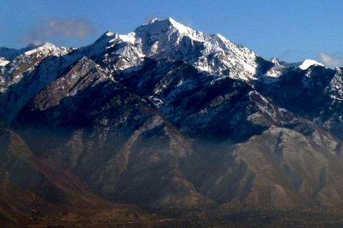
True, but the Wasatch Mountains rise straight out of the city. As mentioned, Alta is only seven miles from the Salt Lake Valley. In late June, you can literally sit in 100 degree heat, hop in the car and have a snowball fight less than 20 minutes later. To point out just how steep the Wasatch Range rises above the city (especially in the south end of the valley), the straight line distance from the summit of Twin Peaks (which always has snowbanks on it except during an extreme drought) at 11,328 feet to the valley floor which is below 5000 feet is only 3.6 miles. The mountains are so close that from the alpine cirque in the photo below, you can actually here the faint hum of traffic and car horns!

...Denver is too dry for my taste but I could visit in January or February!
Anyway, unless you ski (which is great there) or want to visit the mountains, winter is actually the least pleasant time to visit Salt Lake. The mountains are beautiful, but the inversions can be nasty. It actually looks cool to be in the mountains looking down on the fog, but to be down in the fog, it’s actually nasty. It’s worse than Denver’s “brown cloud” since the mountains trap all the pollution in. Check out some of these photos:


As mentioned, it’s cool to look down on, but not to be in:
Usually, it’s even worse than in the above photo. Of course after a fresh snowstorm, everything is new and pretty.
For that matter Grand Junction I would think would be more similar to SLC. Just funny mountain microclimates I guess.
In many ways, it is similar (I used to live in the Grand Junction area too). Temperatures are pretty similar to SLC throughout the year and they too have inversions. On the other hand, Grand Junction is much drier, sunnier and less snowy than SLC (although SLC is still pretty dry and sunny compared to many places).
 The posts in this forum are NOT official forecast and should not be used as such. They are just the opinion of the poster and may or may not be backed by sound meteorological data. They are NOT endorsed by any professional institution or


