thanks for the response...ny nj pa promet
if a -pdo usually leads to a ridge in the gulf of alaska then i would be more bullish on a NE winter being above par.
is there any where (link)to look back at -pdo years and the 500 mb height anomalies in the NE pacific (i.e alaska).....something is amiss from all the different things i have been reading from a couple other pro-mets and i'm twisting my mind to figure it out. I like the way you explain things and i have confidence in your opinions/predictions.
seems like last year with a west best nino New england ...(SNE in particular)...missed a great chance to capitalize on a few snow bombs last winter.....it was like first too much supression... then the blocking became so great that the cold air became so stale that it was near impossible to get a fresh cold air mass capable of giving areas below 1000ft a decent snow after february...i think maine had the highest dewpoints ever for the month of february/march and nearly their highest temps...
Winter 2010-11 for the Southern Plains
Moderator: S2k Moderators
Forum rules
 The posts in this forum are NOT official forecast and should not be used as such. They are just the opinion of the poster and may or may not be backed by sound meteorological data. They are NOT endorsed by any professional institution or STORM2K.

The posts in this forum are NOT official forecast and should not be used as such. They are just the opinion of the poster and may or may not be backed by sound meteorological data. They are NOT endorsed by any professional institution or STORM2K.
-
NY NJ PA Weather
- Professional-Met

- Posts: 22
- Age: 46
- Joined: Fri Sep 10, 2010 9:39 am
- Location: Freehold, New Jersey
- Contact:
Re: Winter 2010-11 for the Southern Plains
cpdaman wrote:thanks for the response...ny nj pa promet
if a -pdo usually leads to a ridge in the gulf of alaska then i would be more bullish on a NE winter being above par.
is there any where (link)to look back at -pdo years and the 500 mb height anomalies in the NE pacific (i.e alaska).....something is amiss from all the different things i have been reading from a couple other pro-mets and i'm twisting my mind to figure it out. I like the way you explain things and i have confidence in your opinions/predictions.
seems like last year with a west best nino New england ...(SNE in particular)...missed a great chance to capitalize on a few snow bombs last winter.....it was like first too much supression... then the blocking became so great that the cold air became so stale that it was near impossible to get a fresh cold air mass capable of giving areas below 1000ft a decent snow after february...i think maine had the highest dewpoints ever for the month of february/march and nearly their highest temps...
As for data, I would use ESRL], it's excellent! http://www.esrl.noaa.gov/psd/data/
Here are the facts. If you are confused about what is going on, don't worry, you should be. Here's the little dirty secret about these seasonal forecasts and that is the skill in forecasting for them is still relatively low. We are getting MUCH better though compared to a decade or even five years ago.
Stating that, you have to remember it's not just the ENSO or -PDO or the state of the QBO that determines the winter. It is a matter of how all of these factors interact, and thus influence each other in developing.
Right now, there are people running around freaking out because the ENSO region NINO 1+2 is rapidly warming. Why is this happening? It is happening because after a significant cool down in this region, the trade winds relaxed and went southwest. Is this the end of La Nina or an east based La Nina. No! It's nothing more than a relaxation. Once this relaxation ends look for La Nina to intensify again, for how long, I'm not sure. However, I have no doubt that a moderate to strong La Nina is in the cards. My only debate is what will the orientation finally be. If I buy into the latest ECMWF ENSO forecast for 3.4, there are indications that my east based idea might just hold. We'll see. This is going to be a fun October!
Oh, and one more thing, keep an eye on that snow growth around NE Alaska, NW Canada, and Siberia. It's already kicking in significantly!
0 likes
Let the Water Vapor Satellite lead the way!
Re: Winter 2010-11 for the Southern Plains
thanks for the reply b/c i was gonna ask about the switch in the east regions and the slight moderating in even the west regions.
hopefully this nina will go east based.....so anything that unbiasedly supports this conclusion i will welcome
hopefully this nina will go east based.....so anything that unbiasedly supports this conclusion i will welcome
0 likes
-
Extremeweatherguy

- Category 5

- Posts: 11095
- Joined: Mon Oct 10, 2005 8:13 pm
- Location: Florida
Re: Winter 2010-11 for the Southern Plains
Wow, what amazing weather today! Mostly sunny, a nice north breeze, and a high temperature that only made it into the upper 60s/lower 70s. You really can not ask for much better than that!
It is going to be a bit on the chilly side tonight though. After several weeks with a minimum temperature struggling to get much lower than the mid 60s to lower 70s, tonight's expected low in the upper 40s is going to feel pretty cold.
It is going to be a bit on the chilly side tonight though. After several weeks with a minimum temperature struggling to get much lower than the mid 60s to lower 70s, tonight's expected low in the upper 40s is going to feel pretty cold.
0 likes
Re: Winter 2010-11 for the Southern Plains
extremeweatherguy
that is some nice cool air....it's great HUH!
there are some cold thicknesses (sub 540) and 850 mb temps on the models (-4 to -6) in the mid range (i.e late weekend) for the great lakes and over to western new england depending on what map model you use.....
that is some nice cool air....it's great HUH!
there are some cold thicknesses (sub 540) and 850 mb temps on the models (-4 to -6) in the mid range (i.e late weekend) for the great lakes and over to western new england depending on what map model you use.....
0 likes
-
Extremeweatherguy
- Category 5
- Posts: 11095
- Joined: Mon Oct 10, 2005 8:13 pm
- Location: Florida
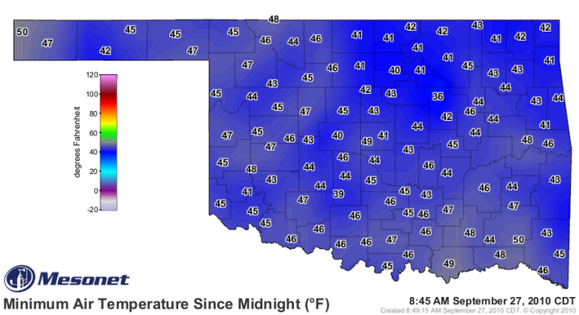


Wow 36  ! That's cold! Odd that far NW Oklahoma was the warmest relatively.
0 likes
The above post and any post by Ntxw is NOT an official forecast and should not be used as such. It is just the opinion of the poster and may or may not be backed by sound meteorological data. It is NOT endorsed by any professional institution including Storm2k. For official information, please refer to NWS products.
Help support Storm2K!
-
amawea

- S2K Supporter

- Posts: 385
- Age: 74
- Joined: Mon Aug 09, 2004 3:36 pm
- Location: Horseshoe Bend, Ar. but from Baytown, Tx
Re: Winter 2010-11 for the Southern Plains
Well, I think we can say winter is on the way based on the temps the past 48 hrs in Alaska. Anaktuvuk Pass had a low of 3 degrees this a.m. The temps have been pretty much in the teens and twenties with light snow the past week. Fairbanks is 17 at 0553 Alaska daylight time right now. Can't be long before the heights build up there and some pretty good fronts come down. This last front was a pretty good one!
I had 43 this a.m on my weather station just outside of Warm Springs, Ar.
I had 43 this a.m on my weather station just outside of Warm Springs, Ar.
0 likes
-
HockeyTx82
- S2K Supporter
- Posts: 2809
- Joined: Tue Oct 27, 2009 11:17 am
- Location: Ponder, TX
Re: Winter 2010-11 for the Southern Plains
FXUS64 KFWD 301732 AAA
AFDFWD
AREA FORECAST DISCUSSION...UPDATED
NATIONAL WEATHER SERVICE FORT WORTH TX
1219 PM CDT THU SEP 30 2010
.UPDATE...
CURRENT FORECAST AND DATA PRODUCTS REMAIN IN GOOD SHAPE WITH NO NEED
FOR A MIDDAY UPDATE. NEAR NORMAL TEMPS/DEW POINTS...GENERALLY CLEAR
SKIES AND NORTHERLY FLOW WILL MAKE FOR PLEASANT WEATHER ACROSS
NORTH TEXAS THROUGH THE WEEKEND AND INTO NEXT WEEK.
APPROACHING COLD FRONT NOW ALONG A LINE FROM THE NORTHERN OZARKS SOUTHWEST
TO NEAR CHILDRESS. THIS FRONT WILL ONLY REINFORCE THE PLEASANT WEATHER
CONDITIONS WE ARE CURRENTLY EXPERIENCING.
LOOKING AHEAD...THE MAIN WEATHER CONCERN FOR NORTH TEXAS WILL BE THE
LOCATION AND MOVEMENT OF NEXT WEEKS UPPER TROUGH/CLOSED LOW SYSTEM
TO OUR WEST. THERE IS DEVELOPING CONSENSUS BETWEEN THE OPERATIONAL MODELS
AND THE ENSEMBLES OF THIS TYPE OF SETUP...BUT THERE REMAINS INCONSISTENCY
IN ITS STRENGTH...PLACEMENT AND DURATION OVER THE SOUTHWEST. IN
ADDITION...THE GFS CONTINUES TO DISAGREE WITH THE ECMWF AND GEM
CONCERNING THE FORMATION OF AN EASTERN CONUS UPPER LOW THE FIRST
OF NEXT WEEK. THESE DISCREPANCIES ARE LIKELY RELATED TO THE AUTUMN
TRANSITION OF THE HEMISPHERIC FLOW PATTERN AND THE STRENGTHENING
OF LA NINA. THE GFS SHOULD BECOME MORE IN LINE WITH THE ECMWF/GEM
SOLUTION BY TOMORROW OR SATURDAY.
What does the last part mean? What could happend next week? Just trying to learn.
0 likes
Don't hold me accountable for anything I post on this forum. Leave the real forecasting up to the professionals.
Location: Ponder, TX (all observation posts are this location unless otherwise noted)
Location: Ponder, TX (all observation posts are this location unless otherwise noted)
^ It really concerns rain. If a cutoff low forms over the southwest we will have rain chances followed by even cooler weather as the nice weather already in place will be accompanied by clouds. Also the pattern is changing to a setup where storms form out west and move across the country bring down chillier air unlike summertime where everything comes up from the gulf.
0 likes
The above post and any post by Ntxw is NOT an official forecast and should not be used as such. It is just the opinion of the poster and may or may not be backed by sound meteorological data. It is NOT endorsed by any professional institution including Storm2k. For official information, please refer to NWS products.
Help support Storm2K!
Help support Storm2K!
-
Extremeweatherguy
- Category 5
- Posts: 11095
- Joined: Mon Oct 10, 2005 8:13 pm
- Location: Florida
Re: Winter 2010-11 for the Southern Plains
Pretty chilly low temperatures are expected the next two nights here in central Oklahoma. The forecast is calling for 43F tonight and 42F tomorrow night. Upper 30s are not completely out of the question if we wind up a few degrees cooler than forecast.
I think it is safe to say that Autumn has definitely arrived in full force.
I think it is safe to say that Autumn has definitely arrived in full force.
0 likes
Re: Winter 2010-11 for the Southern Plains
NE OK has lows down in mid 30's tonite wow. same with southern Missouri next two nights.
last nite had 37.5 in framingham, ma nice crisp cold nite and a bond fire to boot....yeaaa
12z gfs looks chilly for NE as well.
last nite had 37.5 in framingham, ma nice crisp cold nite and a bond fire to boot....yeaaa
12z gfs looks chilly for NE as well.
0 likes
-
amawea
- S2K Supporter
- Posts: 385
- Age: 74
- Joined: Mon Aug 09, 2004 3:36 pm
- Location: Horseshoe Bend, Ar. but from Baytown, Tx
Re: Winter 2010-11 for the Southern Plains
I had a low of 41 this a.m. The low tonight is for mid to upper 30's with scattered frost. It has been a beautiful weekend except for the wind. It's 61 right now and with the wind a sweat shirt and light jacket feels good.
Northeast Alaska is in the upper 20's with snow. There has been a lot of light snow showing up in their current conditions feature for the past two weeks.
Fall! I love it!
Northeast Alaska is in the upper 20's with snow. There has been a lot of light snow showing up in their current conditions feature for the past two weeks.
Fall! I love it!
0 likes
Definitely is changing. Guess it's time to be looking to first frosts and freezes for different areas. Any takers?
0 likes
The above post and any post by Ntxw is NOT an official forecast and should not be used as such. It is just the opinion of the poster and may or may not be backed by sound meteorological data. It is NOT endorsed by any professional institution including Storm2k. For official information, please refer to NWS products.
Help support Storm2K!
Help support Storm2K!

Re: Winter 2010-11 for the Southern Plains
66 in carrollton, very nice outside.. Is it suppose to stay like this though or is it going to get warm again!!? Hoping it stays like this and can't wait for winter!
0 likes
-
Extremeweatherguy
- Category 5
- Posts: 11095
- Joined: Mon Oct 10, 2005 8:13 pm
- Location: Florida
Re: Winter 2010-11 for the Southern Plains
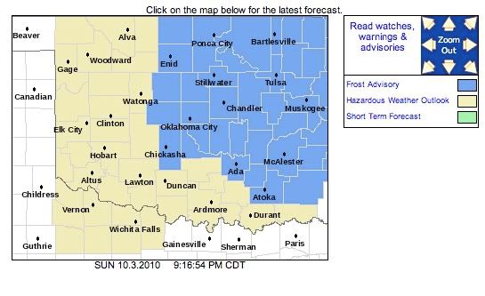
A frost advisory has been issued tonight that stretches into central Oklahoma (just east of my location):
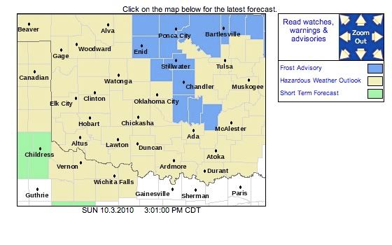
The forecast wording for my location just west of the advisory zone also includes the word "frost" tonight:
Pretty cold for early October!
**UPDATE: Frost advisory has been expanded westward and now includes the OKC Metro area!**
The forecast wording for my location just west of the advisory zone also includes the word "frost" tonight:
Tonight...Partly cloudy. Patchy frost after midnight. Lows in the upper 30s. Light and variable winds.
Pretty cold for early October!
**UPDATE: Frost advisory has been expanded westward and now includes the OKC Metro area!**
Last edited by Extremeweatherguy on Sun Oct 03, 2010 9:19 pm, edited 2 times in total.
0 likes
Re: Winter 2010-11 for the Southern Plains
If things hold to par, week of the 11th (week after this one) could introduce yet chillier temps. EC and Gfs depict 50s/60s for highs in parts of the southern plains. Possibly 30s overnight associated with a digging trough.
Dewpoints across Oklahoma and north Texas are in the 30s! Talk about chap lips.
Dewpoints across Oklahoma and north Texas are in the 30s! Talk about chap lips.
0 likes
The above post and any post by Ntxw is NOT an official forecast and should not be used as such. It is just the opinion of the poster and may or may not be backed by sound meteorological data. It is NOT endorsed by any professional institution including Storm2k. For official information, please refer to NWS products.
Help support Storm2K!
Help support Storm2K!
Re: Winter 2010-11 for the Southern Plains
beech mountain, Nc @ 4900' is f 36.6 dp 36.3 with a light rain shower right now.....not to far away from sleet or snow mix..... prob will in the next 72 hours as Upper low is nearby.....and 3 standard deviations stronger than normal...Per HPC disco
0 likes
-
Extremeweatherguy
- Category 5
- Posts: 11095
- Joined: Mon Oct 10, 2005 8:13 pm
- Location: Florida
Re: Winter 2010-11 for the Southern Plains
A look at the low temperatures this morning across Oklahoma:
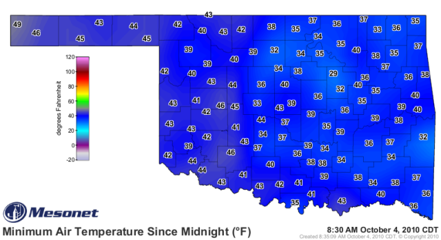
Coldest: 29F
Warmest: 49F
I don't think we will be seeing temperatures this cold again anytime soon. It looks like starting later this week and into the weekend we will be entering an Indian Summer. High temperatures are expected to soar into the middle and upper 80s by Friday and Saturday, which is a good 10+ degrees above average, and lows will return to the middle and upper 50s to near 60F. We will probably have to wait at least 7-10 days before our next shot at a significant cool down across the southern plains.
Coldest: 29F
Warmest: 49F
I don't think we will be seeing temperatures this cold again anytime soon. It looks like starting later this week and into the weekend we will be entering an Indian Summer. High temperatures are expected to soar into the middle and upper 80s by Friday and Saturday, which is a good 10+ degrees above average, and lows will return to the middle and upper 50s to near 60F.
Last edited by Extremeweatherguy on Mon Oct 04, 2010 12:52 pm, edited 1 time in total.
0 likes

Re: Winter 2010-11 for the Southern Plains
Being that I live in the Deep South what are the models forecasting for the next week here? We have some nice mid 50's here last night, but when you live here it's mainly the humidity that kills us. I welcomed the lower humidity and even though were in the 80's yesterday the low humidity almost kept me from breaking a sweat. It was awesome!
0 likes
Who is online
Users browsing this forum: No registered users and 221 guests