12/8 18Z operational GFS
At precip cutoff time, temps in Celsius for 500, 850, and 925 meter levels with total event precip:
Amarillo -16, 1, 6, 0.17
Austin -16, 11, 17, 0.64
Dallas -17, 8, 15, 1.68
Houston -12, 11, 16, 0.39
Lubbock -19, 3, 9, 0.59
San Angelo -20, 9, 16,, 0.26
San Antonio -12, 11, 17, 0.40
Texarkana -12, 7, 11, 0.81
Waco -19, 10, 16, 1.44
Texas Winter 2014-2015
Moderator: S2k Moderators
Forum rules
 The posts in this forum are NOT official forecast and should not be used as such. They are just the opinion of the poster and may or may not be backed by sound meteorological data. They are NOT endorsed by any professional institution or STORM2K.

The posts in this forum are NOT official forecast and should not be used as such. They are just the opinion of the poster and may or may not be backed by sound meteorological data. They are NOT endorsed by any professional institution or STORM2K.

Re: Re:
srainhoutx wrote:Ralph's Weather wrote:I am going to be paying close attention to the 850 temps as that will be the tell for what the precip types will be. I have seen these lows produce good snow when surface temps were progged to be way warm. I am going to review a storm from about this time in 2008 I think to see how it compares, I was in College Station at the time and we got a good 3 or so inches overnight.
That particular December bowling ball cold core upper low brought snow across Metro Houston as well. Some locations on the E side near Pasadena/Channelview/La Porte recorded nearly 6-8 inches of snow and it closed the Fred Hartman Bridge between La Porte and Baytown as well as the 610 E Loop and East Belt Bridges over the ship channel.
Temperature Data For 12/10/2008 Snow
12/7/2008 65/38
12/8/2008 72/45
12/9/2008 78/43
12/10/2008 43/32 Snow
12/11/2008 56/33
12/12/2008 64/32
12/13/2008 72/38
It did not get really cold during the December 2008 snow event. It shows cold weather is not necessary for snow.
0 likes

Re: Re:
Ptarmigan wrote:Temperature Data For 12/10/2008 Snow
12/7/2008 65/38
12/8/2008 72/45
12/9/2008 78/43
12/10/2008 43/32 Snow
12/11/2008 56/33
12/12/2008 64/32
12/13/2008 72/38
It did not get really cold during the December 2008 snow event. It shows cold weather is not necessary for snow.
Too cold doesn't mean snow either. We can attest last year. There's a fine line in Texas you have to cross. Our best odds are when it is cold aloft and a little warm below and then slowly transition. Strong vorticity doesn't hurt either
0 likes
The above post and any post by Ntxw is NOT an official forecast and should not be used as such. It is just the opinion of the poster and may or may not be backed by sound meteorological data. It is NOT endorsed by any professional institution including Storm2k. For official information, please refer to NWS products.
Help support Storm2K!
-
Nairobi
Re:
TheProfessor wrote:From what I can tell the clouds didn't clear today, keeping our temperature 8 degrees cooler than forecasted. Was that a result of the El Nino?
A baja low out west is pulling up the STJ. That's what brought back clouds especially at the mid levels from the Pacific. It is usually Nino climo yeah it will happen more often than not this winter. Posted the map last night, worth posting again! Jut beautiful stuff.

0 likes
The above post and any post by Ntxw is NOT an official forecast and should not be used as such. It is just the opinion of the poster and may or may not be backed by sound meteorological data. It is NOT endorsed by any professional institution including Storm2k. For official information, please refer to NWS products.
Help support Storm2K!
Help support Storm2K!
-
Portastorm

- Storm2k Moderator

- Posts: 9955
- Age: 63
- Joined: Fri Jul 11, 2003 9:16 am
- Location: Round Rock, TX
- Contact:
Re:
Nairobi wrote:JMA still lifts this weekend's trough through the Texas panhandle into Oklahoma instead of across Texas.
Austin's biggest snows (not talking about sleet or freezing rain) in the last 30 years already had the below freezing temps in place when the snow arrived..
European (12z) operational still moves a strong upper low across North Texas.
0 likes
Any forecasts under my name are to be taken with a grain of salt. Get your best forecasts from the National Weather Service and National Hurricane Center.
-
Nairobi
-
Portastorm
- Storm2k Moderator
- Posts: 9955
- Age: 63
- Joined: Fri Jul 11, 2003 9:16 am
- Location: Round Rock, TX
- Contact:
Re:
Nairobi wrote:That ECMWF run moves it through quickly and centered along the Red River.
It progs Austin for 0.8 inches of rain with near 70 degree surface temperatures. Dallas two inches of rain with roughly 65 surface temp. Even Oklahoma City stays in the 50s with moderate to heavy rain.
We appear to be looking at two different 12z Euro models or one of us isn't reading it correctly. Per Levi Cowan's model page, the vorticity max extends from southern Oklahoma into North Texas by 168 hours by my reading.
I guess the GFS model is the one cutting off the low, per EWX's afternoon AFD.
0 likes
Any forecasts under my name are to be taken with a grain of salt. Get your best forecasts from the National Weather Service and National Hurricane Center.
-
Nairobi
I pointed to the center, where the closed low is progged to be.
The high in Houston on 10 December 2008 was reached at midnight, as the cold front came through several hours before. Temps dropped throughout the day. The first official observation of snow was around 4:30 pm at 34 degrees after several hours of very cold light rain.
The high in Houston on 10 December 2008 was reached at midnight, as the cold front came through several hours before. Temps dropped throughout the day. The first official observation of snow was around 4:30 pm at 34 degrees after several hours of very cold light rain.
0 likes
-
Nairobi
Re: Texas Winter 2014-2015
The 500mb trough bringing moisture into the southwest as noted by NTWX is well depicted here:
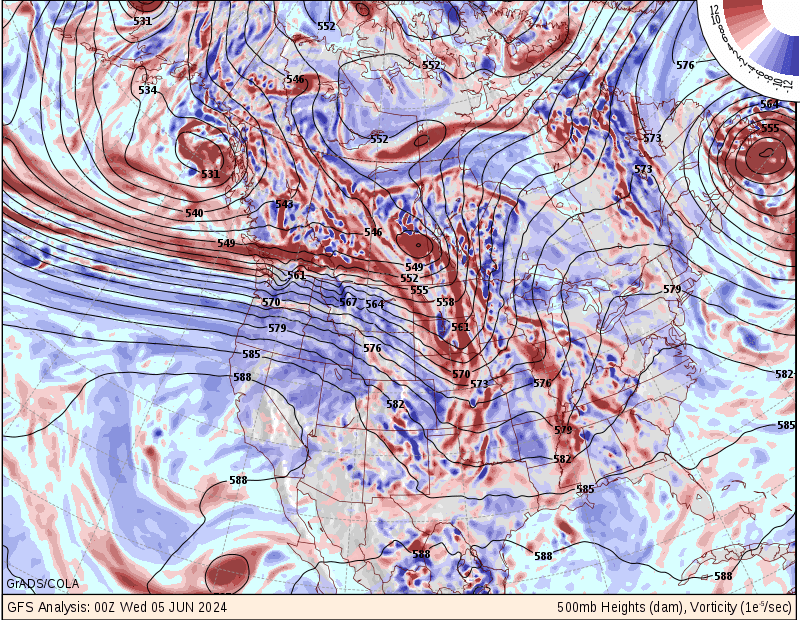
Notice the much higher precipitable water lingering (poised?) near and off the Texas lower coast.
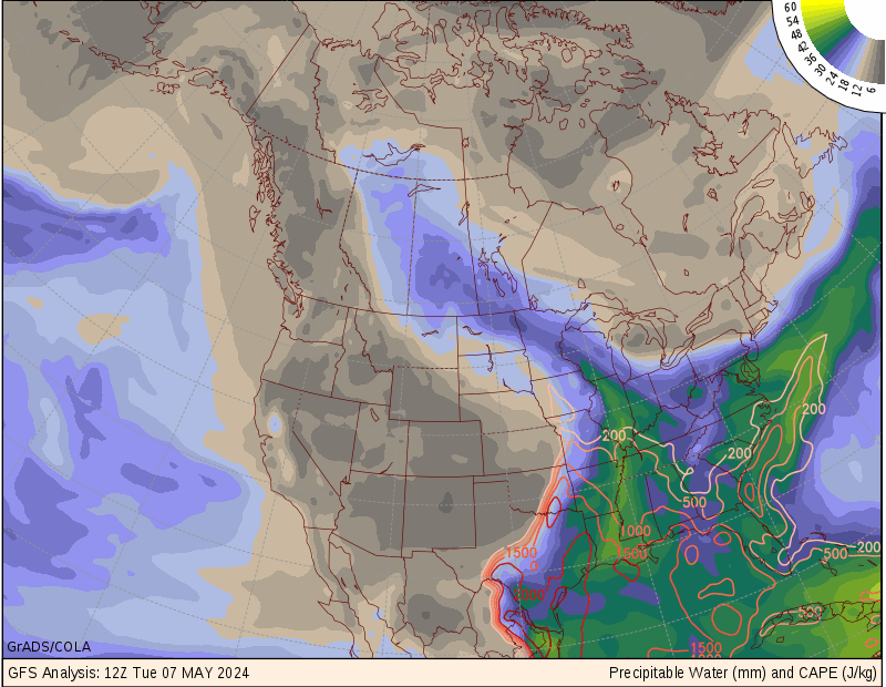
Notice the much higher precipitable water lingering (poised?) near and off the Texas lower coast.
0 likes
Re: Re:
Ntxw wrote:Ptarmigan wrote:Temperature Data For 12/10/2008 Snow
12/7/2008 65/38
12/8/2008 72/45
12/9/2008 78/43
12/10/2008 43/32 Snow
12/11/2008 56/33
12/12/2008 64/32
12/13/2008 72/38
It did not get really cold during the December 2008 snow event. It shows cold weather is not necessary for snow.
Too cold doesn't mean snow either. We can attest last year. There's a fine line in Texas you have to cross. Our best odds are when it is cold aloft and a little warm below and then slowly transition. Strong vorticity doesn't hurt either
Very true. Usually when it snows, it is not that cold. After the snow, it is cold. I have seen snow in very cold freezes like in 1989, but for the most part, it is usually not that cold.
0 likes
-
TeamPlayersBlue

- Category 5

- Posts: 3533
- Joined: Tue Feb 02, 2010 1:44 am
- Location: Denver/Applewood, CO
Nairobi wrote:I pointed to the center, where the closed low is progged to be.
The high in Houston on 10 December 2008 was reached at midnight, as the cold front came through several hours before. Temps dropped throughout the day. The first official observation of snow was around 4:30 pm at 34 degrees after several hours of very cold light rain.
It wasnt raining prior to snow falling. Temp was about 39 when it began to fall i believe.
Also, up above you said it would be raining and 70? Maybe in the summer time, not in the winter. HIGHLY doubt that. Mid 50's sounds reasonable especially for a cold core low.
0 likes
Personal Forecast Disclaimer:
The posts in this forum are NOT official forecast and should not be used as such. They are just the opinion of the poster and may or may not be backed by sound meteorological data. They are NOT endorsed by any professional institution or storm2k.org. For official information, please refer to the NHC and NWS products.
The posts in this forum are NOT official forecast and should not be used as such. They are just the opinion of the poster and may or may not be backed by sound meteorological data. They are NOT endorsed by any professional institution or storm2k.org. For official information, please refer to the NHC and NWS products.
-
Nairobi
Re:
TeamPlayersBlue wrote:Nairobi wrote:I pointed to the center, where the closed low is progged to be.
The high in Houston on 10 December 2008 was reached at midnight, as the cold front came through several hours before. Temps dropped throughout the day. The first official observation of snow was around 4:30 pm at 34 degrees after several hours of very cold light rain.
It wasnt raining prior to snow falling. Temp was about 39 when it began to fall i believe.
Also, up above you said it would be raining and 70? Maybe in the summer time, not in the winter. HIGHLY doubt that. Mid 50's sounds reasonable especially for a cold core low.
Per weatherunderground's hourly archive, it was raining lightly and then turned to snow at 34 degrees. I have no reason to doubt it.
I don't make forecasts. I'm just "parroting" the model output. Austin is not progged to be under the closed low at any point per the ECMWF. The source is here:
http://www.yr.no/place/United_States/Te ... /long.html
0 likes
-
Nairobi
Re: Texas Winter 2014-2015
ECMWF operational 12/9 0Z run is much drier for Texas with the low taking a northerly track like the JMA has been predicting. Austin now progged for only 0.2 inches of rain. Dallas 0.6. Okla City less than half an inch.
0 likes
-
Nairobi


-
Nairobi
Re: Texas Winter 2014-2015
No part of Texas gets snow per the GFS:

And only a small part of the Texas panhandle gets snow per the parallel GFS:

And only a small part of the Texas panhandle gets snow per the parallel GFS:
Last edited by Nairobi on Tue Dec 09, 2014 8:07 am, edited 1 time in total.
0 likes
-
Nairobi
-
Portastorm
- Storm2k Moderator
- Posts: 9955
- Age: 63
- Joined: Fri Jul 11, 2003 9:16 am
- Location: Round Rock, TX
- Contact:
Re: Texas Winter 2014-2015
Widely divergent model runs have muddied the picture for our late weekend storm. Pro met Jeff Lindner's note this morning:
A few days of mainly clear skies will give way to clouds and a slight chance of rain starting on Wednesday. Bigger weather maker possible by the weekend.
Surface high pressure over the region this morning is maintain a weak ENE to NE flow with widespread seasonal temperatures in the 40’s. Satellite images show a short wave disturbance over southern AZ moving eastward with an active sub-tropical jet stream and axis of mid and high level moisture extending from NE MX across Baja and into the Pacific Ocean. This disturbance and its associated mid and high level moisture will move eastward into TX over the next 24-36 hours. Overall trend is for the short wave to dampen or weaken with time. Lift and moisture may be just enough to produce a few spotty rain showers by late Wednesday into Thursday mainly west of I-45 otherwise this system will likely just increase cloud decks over the region. Increased clouds will help keep daytime highs a bit cooler on Wednesday and Thursday (low to mid 60’s) versus the near 70 today.
Strong storm system over the northern Pacific will move onshore the west coast via California late this week and across the SW US early this weekend. Global model guidance is having a difficult time with the track of this system and have been swinging widely between runs. For example the overnight guidance places the core of the upper air system some 300-500 miles north over yesterday morning. An upper air low looks to become cut off in the base of this trough and take on somewhat of a negative tilt orientation as it ejects out of the SW US into the plains. Questions are certainly there with respect to moisture return quality off the Gulf of Mexico. Latest GFS guidance only shows dewpoints in the mid 50’s by Sunday suggesting good quality moisture may be lacking especially for any strong to severe thunderstorms. For now will go with increasing warm air advection starting late Friday into Saturday with mainly just increased low level cloud decks. Will hold off rain chances until Sunday and hopefully models will come into better agreement over the next few days on the track of the upper air system and the resulting impacts across our region for late in this weekend.
0 likes
Any forecasts under my name are to be taken with a grain of salt. Get your best forecasts from the National Weather Service and National Hurricane Center.
-
orangeblood
- S2K Supporter

- Posts: 3895
- Joined: Tue Dec 15, 2009 6:14 pm
- Location: Fort Worth, TX
Re: Texas Winter 2014-2015
Longer term pattern change is evolving quite nicely on the GFS Ensembles....Alaskan ridge with potential cross polar flow setting up towards the latter third of the month. Cold and stormy look that could last quite awhile with the blocking towards the Davis Strait depicted! Almost textbook if you're a winter weather lover

0 likes
-
srainhoutx

- S2K Supporter
- Posts: 6919
- Age: 68
- Joined: Sun Jan 14, 2007 11:34 am
- Location: Haywood County, NC
- Contact:
Re: Texas Winter 2014-2015
The CFS for the last two cycles has virtually all of North America with below to much below normal temperature anomalies. As stated yesterday, the active southern stream storms will likely lead to a stepping down process with each storm system dragging a bit more cold air S into the Lower 48. This fast moving parade of storms will move across California, the Desert SW, Northern Mexico, the Southern Rockies and the Southern Plains into the foreseeable future. As the Polar jet buckles in about a week, look for the process to accelerate the whole scale pattern change across much of North America. Patience grasshoppers, it's coming. 
0 likes
Carla/Alicia/Jerry(In The Eye)/Michelle/Charley/Ivan/Dennis/Katrina/Rita/Wilma/Ike/Harvey
Member: National Weather Association
Wx Infinity Forums
http://wxinfinity.com/index.php
Facebook.com/WeatherInfinity
Twitter @WeatherInfinity
Member: National Weather Association
Wx Infinity Forums
http://wxinfinity.com/index.php
Facebook.com/WeatherInfinity
Twitter @WeatherInfinity
Who is online
Users browsing this forum: No registered users and 145 guests