Winter Weather Discussion
Moderator: S2k Moderators
Forum rules
 The posts in this forum are NOT official forecast and should not be used as such.
 They are just the opinion of the poster and may or may not be backed by sound meteorological data. They are NOT endorsed by any professional institution or
STORM2K.
-
GeauxTigers
- Tropical Storm

- Posts: 112
- Joined: Sun Jan 14, 2018 5:35 pm
- Location: Tioga, TX
#4521 Postby GeauxTigers » Fri Jan 23, 2026 11:54 pm
cheezyWXguy wrote:GeauxTigers wrote:cheezyWXguy wrote: With the cold air out west gradually expanding east, and the other surge of cold air coming in from Texarkana, the i35 corridor will probably be the last place to drop below freezing in the immediate metro since that’s about where they’ll ultimately meet.
Is that bad news if I’m 35 miles from I35 near Denton? Or just a delay for the frozen stuff?
Nah, no delay. The subfreezing air was modeled to flood into the area in this way, and it’s still faster that models like the nam and hrrr have been depicting. You also probably won’t see much freezing rain accumulation at ground level at 31/32 degrees, it’ll mainly be on taller things like trees or roofs at those temps. Maybe on your car?
So does that mean my area (Tioga, TX) will get less frzg rain overnight? Or is everything still on track for up here for frz rain overnight night and big sleet tomorrow afternoon with 2nd wave?
0 likes
-
cheezyWXguy
- Category 5

- Posts: 6272
- Joined: Mon Feb 13, 2006 12:29 am
- Location: Dallas, TX
#4522 Postby cheezyWXguy » Sat Jan 24, 2026 12:00 am
GeauxTigers wrote:cheezyWXguy wrote:GeauxTigers wrote:Is that bad news if I’m 35 miles from I35 near Denton? Or just a delay for the frozen stuff?
Nah, no delay. The subfreezing air was modeled to flood into the area in this way, and it’s still faster that models like the nam and hrrr have been depicting. You also probably won’t see much freezing rain accumulation at ground level at 31/32 degrees, it’ll mainly be on taller things like trees or roofs at those temps. Maybe on your car?
So does that mean my area (Tioga, TX) will get less frzg rain overnight? Or is everything still on track for up here for frz rain overnight night and big sleet tomorrow afternoon with 2nd wave?
Seems to be on track to me, the exact temperature you’re at right now isn’t going to matter much in the grand scheme of things. How much freezing rain vs sleet vs snow we all end up with by the end of this is the million dollar question.
2 likes
-
WacoWx
- Category 2

- Posts: 686
- Joined: Mon Dec 28, 2009 4:14 pm
- Location: NOT Waco, TX ----> Dallas, TX
#4523 Postby WacoWx » Sat Jan 24, 2026 12:02 am
WacoWx wrote:
At 8a 1/23/26:
9a 50°
10a 49
11a 50 Actual = 47.1°
12p 49
1p 48
2p 47 Actual = 44.2°
3p 46
4p 43
5p 41 Actual = 42.8°
6p 40° Actual = 39.4°
7p 38
8p 37
9p 37
10p 36
11p 36 Actual = 33.6
12a 35
1:00a 34
2a 33
3a 32
4a 32
5a 31
6a 30°
4 likes
-
Iceresistance
- Category 5
- Posts: 9536
- Age: 22
- Joined: Sat Oct 10, 2020 9:45 am
- Location: Tecumseh, OK/Norman, OK
#4524 Postby Iceresistance » Sat Jan 24, 2026 12:04 am
I just measured again, I am now up to 2.5 inches of snow. This is wild
5 likes
Bill 2015 & Beta 2020
Winter 2020-2021 
All observations are in Tecumseh, OK unless otherwise noted.
Winter posts are focused mainly for Oklahoma & Texas.
Take any of my forecasts with a grain of salt, refer to the NWS, SPC, and NHC for official information
Never say
Never with weather! Because
ANYTHING is possible!
-
GeauxTigers
- Tropical Storm
- Posts: 112
- Joined: Sun Jan 14, 2018 5:35 pm
- Location: Tioga, TX
#4525 Postby GeauxTigers » Sat Jan 24, 2026 12:06 am
cheezyWXguy wrote:GeauxTigers wrote:cheezyWXguy wrote:Nah, no delay. The subfreezing air was modeled to flood into the area in this way, and it’s still faster that models like the nam and hrrr have been depicting. You also probably won’t see much freezing rain accumulation at ground level at 31/32 degrees, it’ll mainly be on taller things like trees or roofs at those temps. Maybe on your car?
So does that mean my area (Tioga, TX) will get less frzg rain overnight? Or is everything still on track for up here for frz rain overnight night and big sleet tomorrow afternoon with 2nd wave?
Seems to be on track to me, the exact temperature you’re at right now isn’t going to matter much in the grand scheme of things. How much freezing rain vs sleet vs snow we all end up with by the end of this is the million dollar question.
Thank you for your input! Stay safe & i hope you get some white stuff!
1 likes
-
Snowman67
- Category 2
- Posts: 655
- Joined: Thu Dec 31, 2009 12:44 pm
- Location: Tomball, TX
#4526 Postby Snowman67 » Sat Jan 24, 2026 12:10 am
WacoWx wrote:WacoWx wrote:
At 8a 1/23/26:
9a 50°
10a 49
11a 50 Actual = 47.1°
12p 49
1p 48
2p 47 Actual = 44.2°
3p 46
4p 43
5p 41 Actual = 42.8°
6p 40° Actual = 39.4°
7p 38
8p 37
9p 37
10p 36
11p 36 Actual = 33.6
12a 35
1:00a 34
2a 33
3a 32
4a 32
5a 31
6a 30°
What site are these readings from?
1 likes
Any forecast I make is based on my opinion only. Please refer to the NWS or NHC for official forecasts.
-
txtwister78
- Category 5
- Posts: 2083
- Joined: Wed Jan 30, 2019 12:56 pm
- Location: San Antonio
#4527 Postby txtwister78 » Sat Jan 24, 2026 12:12 am
Man that signal continues to grow on the GFS ENS for late next week into the weekend. Going to be pushing 400 pages on here if that continues.
6 likes
-
rendihess
- Tropical Low

- Posts: 13
- Joined: Mon Oct 01, 2018 12:30 pm
- Location: Dallas (Flower Mound)
#4528 Postby rendihess » Sat Jan 24, 2026 12:14 am
Longtime lurker here. First thank you for all the info you guys provide us! Question. Why is Flower Mound just sitting at 34 degrees. It’s just not getting colder! Lol! Will it? Or am I doomed.
2 likes
-
downsouthman1
- Category 2
- Posts: 684
- Age: 46
- Joined: Fri Jan 07, 2011 8:14 pm
- Location: Rowlett, TX
#4529 Postby downsouthman1 » Sat Jan 24, 2026 12:16 am
rendihess wrote:Longtime lurker here. First thank you for all the info you guys provide us! Question. Why is Flower Mound just sitting at 34 degrees. It’s just not getting colder! Lol! Will it? Or am I doomed.
Trust the process. This is a long duration event yall.
Besides the overall pattern that is developing.
3 likes
Not a professional MET! My posts are merely speculation.
-
Iceresistance
- Category 5
- Posts: 9536
- Age: 22
- Joined: Sat Oct 10, 2020 9:45 am
- Location: Tecumseh, OK/Norman, OK
#4530 Postby Iceresistance » Sat Jan 24, 2026 12:18 am
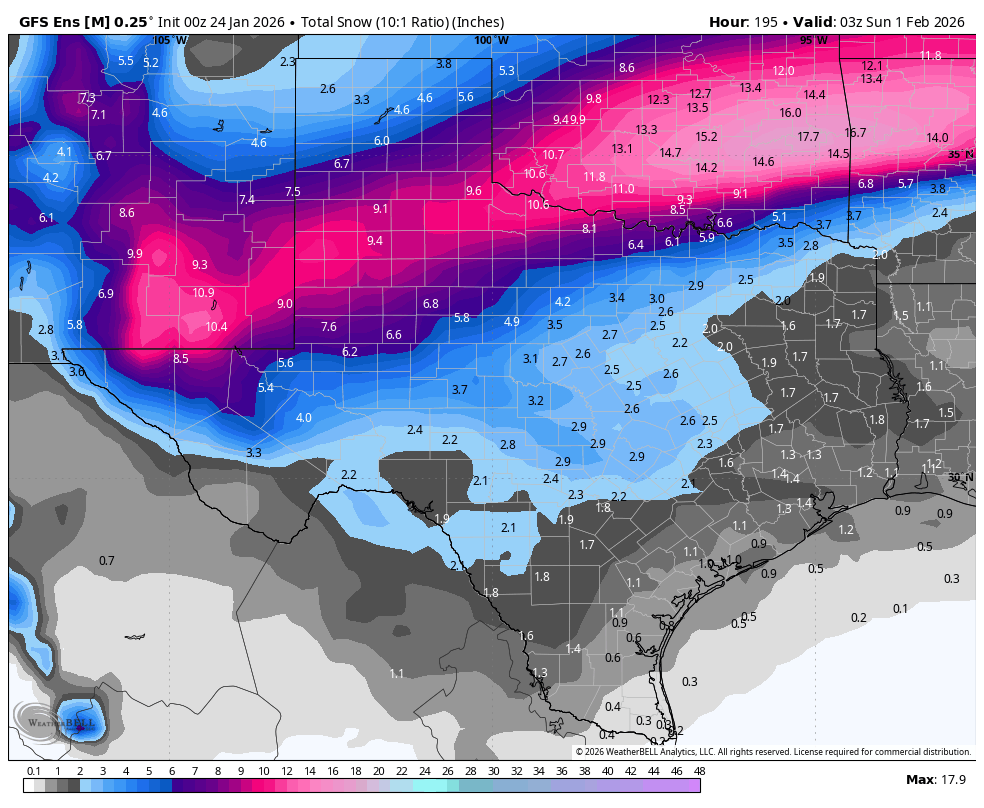
How is it even possible to have over a foot of sleet north of DFW??
 https://s12.gifyu.com/images/bkE6I.png
3 likes
Bill 2015 & Beta 2020
Winter 2020-2021 All observations are in Tecumseh, OK unless otherwise noted.
Winter posts are focused mainly for Oklahoma & Texas.
Take any of my forecasts with a grain of salt, refer to the NWS, SPC, and NHC for official information
Never say
Never with weather! Because
ANYTHING is possible!
-
Captmorg70
- Tropical Storm
- Posts: 195
- Age: 38
- Joined: Mon Dec 18, 2017 12:07 am
- Location: Highland Village Tx
#4531 Postby Captmorg70 » Sat Jan 24, 2026 12:20 am
rendihess wrote:Longtime lurker here. First thank you for all the info you guys provide us! Question. Why is Flower Mound just sitting at 34 degrees. It’s just not getting colder! Lol! Will it? Or am I doomed.
Just north of you in Highland Village/Lewisville. Yea we are staying just slightly above freezing. We’re probably a couple more hours from hitting freezing.
But like already mentioned, long term we will be fine. If anything, we’re just missing out on freezing rain atm.

2 likes
-
WacoWx
- Category 2
- Posts: 686
- Joined: Mon Dec 28, 2009 4:14 pm
- Location: NOT Waco, TX ----> Dallas, TX
#4532 Postby WacoWx » Sat Jan 24, 2026 12:21 am
ludosc wrote:just hit freezing on the west side of McKinney
Hook em!
1 likes
-
UTSARoadrunner4
- Category 1

- Posts: 258
- Age: 29
- Joined: Wed Aug 26, 2020 11:19 pm
#4533 Postby UTSARoadrunner4 » Sat Jan 24, 2026 12:21 am
A slight deviation from the winter festivities in Oklahoma, South Oklahoma, and Arkansas.
Moderate downpour in Northern Bexar County. Definitely nice to see some rain. Would’ve been better if it was snow. Hopefully what the models are showing for next week actually verifies.
3 likes
-
GeauxTigers
- Tropical Storm
- Posts: 112
- Joined: Sun Jan 14, 2018 5:35 pm
- Location: Tioga, TX
#4534 Postby GeauxTigers » Sat Jan 24, 2026 12:23 am
I’m in the county showing 12.5- south Grayson county. That would be amazing if it verified!
5 likes
-
rwfromkansas
- Category 5
- Posts: 2923
- Joined: Sat Aug 27, 2005 12:47 am
- Location: North Fort Worth
#4535 Postby rwfromkansas » Sat Jan 24, 2026 12:23 am
Heavy sleet video from Abilene on FB. Just coming down.
0 likes
-
snownado
- Category 5
- Posts: 1041
- Joined: Sat Dec 09, 2023 7:00 pm
- Location: Plano, TX
#4536 Postby snownado » Sat Jan 24, 2026 12:24 am
Nederlander wrote:Crazy how one place can produce snow like that and also violent tornadoes…
That's the Plains for ya...
2 likes
-
WacoWx
- Category 2
- Posts: 686
- Joined: Mon Dec 28, 2009 4:14 pm
- Location: NOT Waco, TX ----> Dallas, TX
#4537 Postby WacoWx » Sat Jan 24, 2026 12:26 am
Snowman67 wrote:WacoWx wrote:WacoWx wrote:
At 8a 1/23/26:
9a 50°
10a 49
11a 50 Actual = 47.1°
12p 49
1p 48
2p 47 Actual = 44.2°
3p 46
4p 43
5p 41 Actual = 42.8°
6p 40° Actual = 39.4°
7p 38
8p 37
9p 37
10p 36
11p 36 Actual = 33.6
12a 35
1:00a 34
2a 33
3a 32
4a 32
5a 31
6a 30°
What site are these readings from?
Weather.com at 9a this morning. Just a daily benchmark test.
1 likes
-
rendihess
- Tropical Low
- Posts: 13
- Joined: Mon Oct 01, 2018 12:30 pm
- Location: Dallas (Flower Mound)
#4538 Postby rendihess » Sat Jan 24, 2026 12:27 am
Captmorg70 wrote:rendihess wrote:Longtime lurker here. First thank you for all the info you guys provide us! Question. Why is Flower Mound just sitting at 34 degrees. It’s just not getting colder! Lol! Will it? Or am I doomed.
Just north of you in Highland Village/Lewisville. Yea we are staying just slightly above freezing. We’re probably a couple more hours from hitting freezing.
But like already mentioned, long term we will be fine. If anything, we’re just missing out on freezing rain atm.
Okay. Thank you so much. I’ve been sitting here forever thinking the cold was moving in quicker then it stalled and I panicked. I appreciate the reply and the ease of mind. Nobody wants freezing rain. Ha! Thanks again! ☺️
2 likes
-
Brent
- S2K Supporter

- Posts: 38627
- Age: 37
- Joined: Sun May 16, 2004 10:30 pm
- Location: Tulsa Oklahoma
-
Contact:
#4539 Postby Brent » Sat Jan 24, 2026 12:29 am
snownado wrote:Nederlander wrote:Crazy how one place can produce snow like that and also violent tornadoes…
That's the Plains for ya...
Oh I'm tripping people out on Facebook when I tell them it was 87 on Christmas!
2 likes
#neversummer
-
cheezyWXguy
- Category 5
- Posts: 6272
- Joined: Mon Feb 13, 2006 12:29 am
- Location: Dallas, TX
#4540 Postby cheezyWXguy » Sat Jan 24, 2026 12:33 am
Radar is filling in nicely south of San Angelo at the moment, that'll be moving toward the metro in a couple of hours. Think by then there would be few if any areas that haven't reached freezing north of I20. Prior to that, anyone not at freezing yet is just missing out on some freezing drizzle. No worries here.
6 likes
Return to “Winter Weather”
Who is online
Users browsing this forum: 869MB, Browndog, bubba hotep, Captmorg70, cheezyWXguy, CSpringer, downsouthman1, Fifty Rock, Greener, Harp.1, JayDT, Kasenaff7, mmmmsnouts, Ralph's Weather, ravyrn, rendihess, rwfromkansas, Stratton23, Texas Snowman, ThunderSleetDreams, TomballEd, txtwister78, WeatherP1, Will_TX and 169 guests


