Winter Weather Discussion
Moderator: S2k Moderators
Forum rules
 The posts in this forum are NOT official forecast and should not be used as such.
 They are just the opinion of the poster and may or may not be backed by sound meteorological data. They are NOT endorsed by any professional institution or
STORM2K.
-
snownado
- Category 5

- Posts: 1037
- Joined: Sat Dec 09, 2023 7:00 pm
- Location: Plano, TX
#4181 Postby snownado » Fri Jan 23, 2026 9:56 am
cheezyWXguy wrote:I think he’s saying it’s an indication it could be trending in that direction, not necessarily that the verbatim output currently shows it
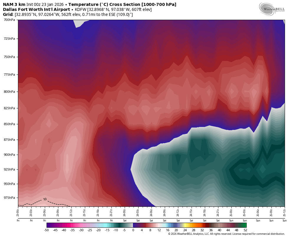
Look at the chart I shared again. There's no way a projected 5-8*C warm nose that is 5,000ft+ deep is just going to trend away in less than 48 hours away.
I'd give up hope of any appreciable snowfall at this point for DFW. Of course, it would be a bonus if anything does fall (and there's still a small chance we could see some light snow that leaves a coating on the tail end).
Last edited by
snownado on Fri Jan 23, 2026 9:58 am, edited 4 times in total.
0 likes
-
Brent
- S2K Supporter

- Posts: 38611
- Age: 37
- Joined: Sun May 16, 2004 10:30 pm
- Location: Tulsa Oklahoma
-
Contact:
#4182 Postby Brent » Fri Jan 23, 2026 9:56 am
Portastorm wrote:Brent wrote:wxman22 wrote:The Mets up here are saying thunder sleet is a real possibility.
Yeah Tulsa mentioned convective too
I think that's where the 20+ inches is coming from. The models trying to show it
Which the Euro again had right over OKC and Tulsa

Enjoy it! Thundersnow/sleet is a rare treat, especially in the Southern Plains. Hope y’all get a storm for the ages but don’t lose power.

Luckily it should be a fairly dry snow here and probably little if any mix im expecting
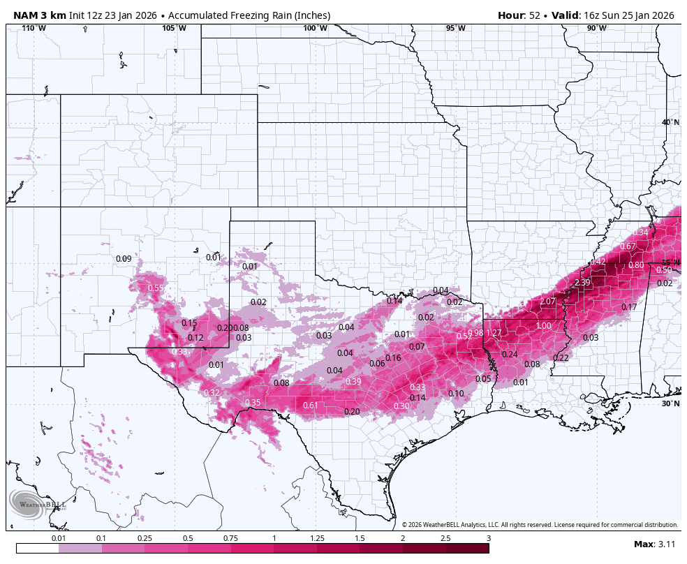
Our friends to the south may not be so lucky. You don't have to go far to get into serious ice
0 likes
#neversummer
-
HockeyTx82
- S2K Supporter
- Posts: 2728
- Joined: Tue Oct 27, 2009 11:17 am
- Location: Ponder, TX
#4183 Postby HockeyTx82 » Fri Jan 23, 2026 9:59 am
Wow, chances of that happening?
Why do I get the feeling that we might have more on the ground and NWS graphics will be playing catch-up?
2 likes
Don't hold me accountable for anything I post on this forum. Leave the real forecasting up to the professionals.
Location: Ponder, TX (all observation posts are this location unless otherwise noted)
-
HockeyTx82
- S2K Supporter
- Posts: 2728
- Joined: Tue Oct 27, 2009 11:17 am
- Location: Ponder, TX
#4184 Postby HockeyTx82 » Fri Jan 23, 2026 10:00 am
This rain might be washing the brine, or diluting it, could make for more of a mess later on.
2 likes
Don't hold me accountable for anything I post on this forum. Leave the real forecasting up to the professionals.
Location: Ponder, TX (all observation posts are this location unless otherwise noted)
-
mmmmsnouts
- Tropical Storm

- Posts: 206
- Joined: Tue Sep 05, 2023 10:04 pm
- Location: Arlington, TX
#4185 Postby mmmmsnouts » Fri Jan 23, 2026 10:05 am
It’s worth noting this is the first time it’s rained at my house (NW Arlington) in almost two months.
8 likes
-
Ralph's Weather
- S2K Supporter
- Posts: 3339
- Age: 38
- Joined: Fri Dec 13, 2013 11:55 am
- Location: Lindale, TX
-
Contact:
#4186 Postby Ralph's Weather » Fri Jan 23, 2026 10:08 am
cstrunk wrote:Ralph's Weather wrote:I saw thundersleet in March 2014, several inches fell in a short time with lots of lightning and thunder. I was living in a metal bardo at the time and it was crazy.
I am liking the trends today going towards more sleet for I-20 corridor. I know I am not matching NWS around here but I do not think my area sees 0.25" of freezing rain. Its risky forecasting the lower freezing rain amounts as it is the difference in utility issues or not. I still say most likely area for the highest ice accretions in northern Deep East Texas.
I hope you're right!
Me too.
0 likes
-
snownado
- Category 5
- Posts: 1037
- Joined: Sat Dec 09, 2023 7:00 pm
- Location: Plano, TX
#4187 Postby snownado » Fri Jan 23, 2026 10:09 am
mmmmsnouts wrote:It’s worth noting this is the first time it’s rained at my house (NW Arlington) in almost two months.
You didn't get any rain on 1/8 or 1/9?
Even we got a bit of rain from that system (albeit, only a couple tenths of a inch at best).
0 likes
-
Cerlin
- Category 5
- Posts: 1188
- Age: 23
- Joined: Thu Dec 08, 2016 12:06 am
- Location: Norman, OK
#4188 Postby Cerlin » Fri Jan 23, 2026 10:12 am
snownado wrote:cheezyWXguy wrote:I think he’s saying it’s an indication it could be trending in that direction, not necessarily that the verbatim output currently shows it
Look at the chart I shared again. There's no way a projected 5-8*C warm nose that is 5,000ft+ deep is just going to trend away in less than 48 hours away.
I'd give up hope of any appreciable snowfall at this point for DFW. Of course, it would be a bonus if anything does fall (and there's still a small chance we could see some light snow that leaves a coating on the tail end).
Eh, I don't blame the skepticism but the NAM is the only one that shows that strong of a warm nose. With how much hydrometeor loading is occurring based on the upper level RH patterns, it wouldn't shock me if there is enough adiabatic cooling to erode that warm nose enough to produce snow, even if that's not until Sunday. But that's almost too hard to forecast at this point and we won't know until this front has fully moved through and we get some real observations.
6 likes
Graduate Meteorology Student at the University of Oklahoma!
All opinions independent of employers and the university.
-
Brandon8181
- S2K Supporter
- Posts: 430
- Age: 42
- Joined: Tue Jan 04, 2011 4:52 pm
- Location: Tyler, TX
-
Contact:
#4189 Postby Brandon8181 » Fri Jan 23, 2026 10:13 am
ThunderSleetDreams wrote:Yall rang? It me.
Nice timing
3 likes
I am not a meteorologist. Any post from me should be taken as hobby or fun educational information, but not an accurate source for weather information. Please, refer to your local weather station or National Weather Service for the most up to date information.

-
Texas Snowman
- Storm2k Moderator

- Posts: 6191
- Joined: Fri Jan 25, 2008 11:29 am
- Location: Denison, Texas
#4190 Postby Texas Snowman » Fri Jan 23, 2026 10:18 am
Friendly reminder time.
For the most part, everyone has been playing by the SK2 rules as this has been unfolding.
But occasionally, I’m thinking we’re steering in the direction of a hurricane landfall day where Moderator’s have to issue warnings, remove inflammatory comments, etc.
Let’s not get too chippy with each other or locked into proving a particular point that we feel compelled to make.
To the hundreds of guests we’ve had visiting this week, thank you for doing so and please consider joining us here.
And as always, defer to the official forecasts being issued by the National Weather Service offices in Texas and elsewhere.
13 likes
The above post and any post by Texas Snowman is NOT an official forecast and should not be used as such. It is just the opinion of the poster and may or may not be backed by sound meteorological data. It is NOT endorsed by any professional institution including storm2k.org. For official information, please refer to NWS products.
-
mmmmsnouts
- Tropical Storm
- Posts: 206
- Joined: Tue Sep 05, 2023 10:04 pm
- Location: Arlington, TX
#4191 Postby mmmmsnouts » Fri Jan 23, 2026 10:20 am
snownado wrote:mmmmsnouts wrote:It’s worth noting this is the first time it’s rained at my house (NW Arlington) in almost two months.
You didn't get any rain on 1/8 or 1/9?
Even we got a bit of rain from that system (albeit, only a couple tenths of a inch at best).
Nope, just barely missed us by a mile or two.
0 likes
-
orangeblood
- S2K Supporter
- Posts: 3841
- Joined: Tue Dec 15, 2009 6:14 pm
- Location: Fort Worth, TX
#4192 Postby orangeblood » Fri Jan 23, 2026 10:22 am
snownado wrote:cheezyWXguy wrote:I think he’s saying it’s an indication it could be trending in that direction, not necessarily that the verbatim output currently shows it
Look at the chart I shared again. There's no way a projected 5-8*C warm nose that is 5,000ft+ deep is just going to trend away in less than 48 hours away.
I'd give up hope of any appreciable snowfall at this point for DFW. Of course, it would be a bonus if anything does fall (and there's still a small chance we could see some light snow that leaves a coating on the tail end).
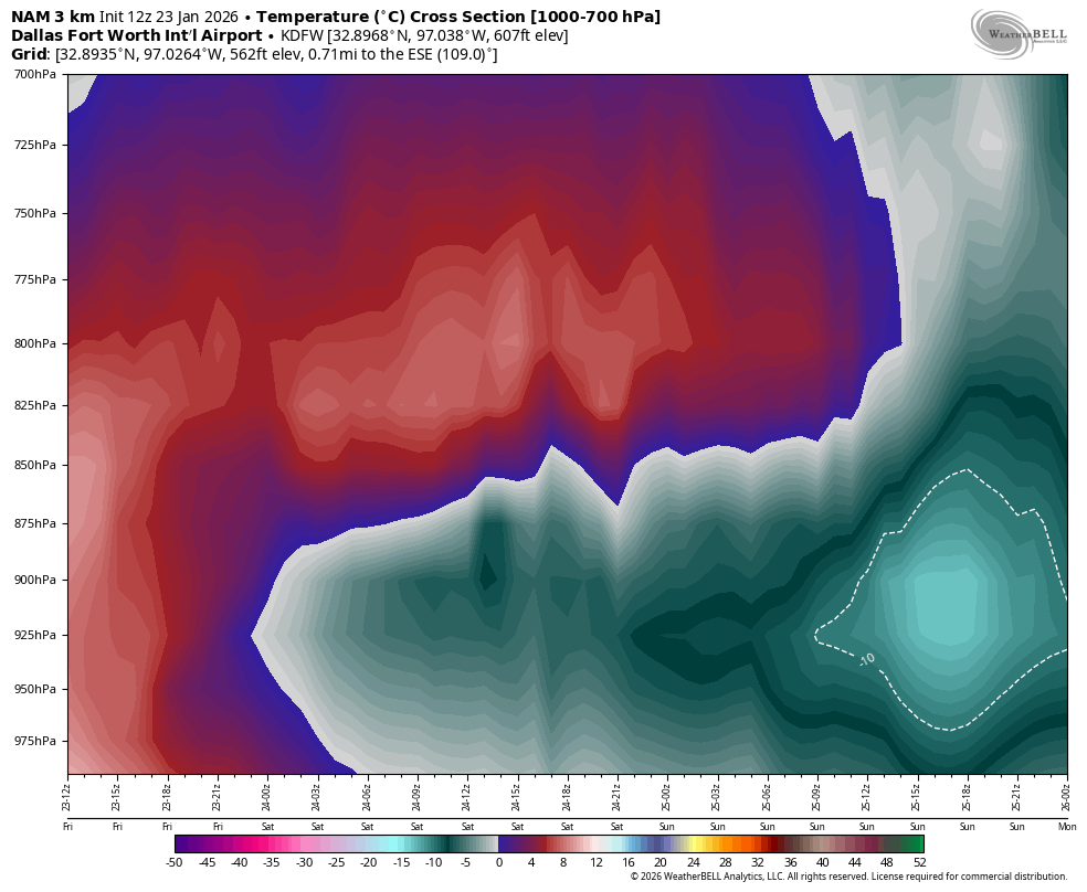
The trend is for a quicker changeover, not to all snow from the onset. Models continue to play catch up across all levels with the cold is my point and at this rate of change, the window that's interesting is when the final heavy qpf moves through on Saturday night between midnight and sunrise Sunday. You get the quicker change over, that could thump a good 3-5" of snow quickly across the metroplex.
Just look at the cool down from last nights NAM run to this mornings, particularly from 06z to 12Z Sunday. It won't take much to bring down frz air from the upper levels to cool the entire column if the DGZ gets cranking
0Z
12Z
4 likes
-
snownado
- Category 5
- Posts: 1037
- Joined: Sat Dec 09, 2023 7:00 pm
- Location: Plano, TX
#4193 Postby snownado » Fri Jan 23, 2026 10:27 am
Cerlin wrote:snownado wrote:cheezyWXguy wrote:I think he’s saying it’s an indication it could be trending in that direction, not necessarily that the verbatim output currently shows it
Look at the chart I shared again. There's no way a projected 5-8*C warm nose that is 5,000ft+ deep is just going to trend away in less than 48 hours away.
I'd give up hope of any appreciable snowfall at this point for DFW. Of course, it would be a bonus if anything does fall (and there's still a small chance we could see some light snow that leaves a coating on the tail end).
Eh, I don't blame the skepticism but the NAM is the only one that shows that strong of a warm nose. With how much hydrometeor loading is occurring based on the upper level RH patterns, it wouldn't shock me if there is enough adiabatic cooling to erode that warm nose enough to produce snow, even if that's not until Sunday. But that's almost too hard to forecast at this point and we won't know until this front has fully moved through and we get some real observations.
The temp profile throughout the entire column will eventually cool to support snow as the precip type, but it's going to be a race against time with the best forcing and mid-level moisture quickly shifting NE Sunday morning. That said, past history with these type of events would suggest the warm nose will not only take longer to completely erode than even the models project, but also that the backside of the precipitation will move in sooner than expected.
I could certainly understand the "dynamic cooling" argument during peak precipitation rates if the warm nose was a mere 1*C and maybe a few hundred feet in depth without a stiff SW wind in the mid-levels. But that's simply not the case here.
BTW, the other models also have a 5,000ft deep warm nose of at least 3-5*C. The GGEM is perhaps the least ugly-looking, but of course we all know it has its own cold bias.


2 likes
-
Cerlin
- Category 5
- Posts: 1188
- Age: 23
- Joined: Thu Dec 08, 2016 12:06 am
- Location: Norman, OK
#4194 Postby Cerlin » Fri Jan 23, 2026 10:30 am
snownado wrote:Cerlin wrote:snownado wrote:
Look at the chart I shared again. There's no way a projected 5-8*C warm nose that is 5,000ft+ deep is just going to trend away in less than 48 hours away.
I'd give up hope of any appreciable snowfall at this point for DFW. Of course, it would be a bonus if anything does fall (and there's still a small chance we could see some light snow that leaves a coating on the tail end).
Eh, I don't blame the skepticism but the NAM is the only one that shows that strong of a warm nose. With how much hydrometeor loading is occurring based on the upper level RH patterns, it wouldn't shock me if there is enough adiabatic cooling to erode that warm nose enough to produce snow, even if that's not until Sunday. But that's almost too hard to forecast at this point and we won't know until this front has fully moved through and we get some real observations.
The temp profile throughout the entire column will eventually cool to support snow as the precip type, but it's going to be a race against time with the best forcing and mid-level moisture quickly shifting NE Sunday morning. That said, past history with these type of events would suggest the warm nose will not only take longer to completely erode than even the models project, but also that the backside of the precipitation will move in sooner than expected.
I could certainly understand the "dynamic cooling" argument during peak precipitation rates if the warm nose was a mere 1*C and maybe a few hundred feet in depth without a stiff SW wind in the mid-levels. But that's simply not the case here.
BTW, the other models also have a 5,000ft deep warm nose of at least 3-5*C. The GGEM is perhaps the least ugly-looking, but of course we all know it has its own cold bias.
[url]https://i.ibb.co/8gnzKr9M/Screenshot-2026-01-23-091428.png [/url]
[url]https://i.ibb.co/3YW2TRT5/Screenshot-2026-01-23-092040.png [/url]
[url]https://i.ibb.co/MDbtQ5Kx/Screenshot-2026-01-23-092227.png [/url]
[url]https://i.ibb.co/Kc1ZDCZ0/Screenshot-2026-01-23-092327.png [/url]
[url]https://i.ibb.co/21WrW3mJ/Screenshot-2026-01-23-092433.png [/url]
Yeah that's a good point, I think those additional plots help show some better context. NAM has struggled with a lot of surface dynamics in the past few years but especially with sleet events it tends to do well with precipitation type. Either way, I'll be very interested to see what some of the post front soundings look like to see which of these models has best captured the initial state of the atmosphere.
1 likes
Graduate Meteorology Student at the University of Oklahoma!
All opinions independent of employers and the university.
-
FamousOrangeCat
- Tropical Wave

- Posts: 1
- Joined: Mon Oct 07, 2024 2:33 pm
- Location: Stillwater OK
#4195 Postby FamousOrangeCat » Fri Jan 23, 2026 10:34 am
Hello from Stillwater, Oklahoma! I'm enjoying everyone's expert interpretation of the models and other data. Temp here is down to 27F, with gusty winds. The biggest snowfall I personally remember in Stillwater was ~8" in 2011. There is only limited plowing capacity here, so this should be interesting...!
3 likes
-
snownado
- Category 5
- Posts: 1037
- Joined: Sat Dec 09, 2023 7:00 pm
- Location: Plano, TX
#4196 Postby snownado » Fri Jan 23, 2026 10:35 am
Cerlin wrote:snownado wrote:Cerlin wrote:
Eh, I don't blame the skepticism but the NAM is the only one that shows that strong of a warm nose. With how much hydrometeor loading is occurring based on the upper level RH patterns, it wouldn't shock me if there is enough adiabatic cooling to erode that warm nose enough to produce snow, even if that's not until Sunday. But that's almost too hard to forecast at this point and we won't know until this front has fully moved through and we get some real observations.
The temp profile throughout the entire column will eventually cool to support snow as the precip type, but it's going to be a race against time with the best forcing and mid-level moisture quickly shifting NE Sunday morning. That said, past history with these type of events would suggest the warm nose will not only take longer to completely erode than even the models project, but also that the backside of the precipitation will move in sooner than expected.
I could certainly understand the "dynamic cooling" argument during peak precipitation rates if the warm nose was a mere 1*C and maybe a few hundred feet in depth without a stiff SW wind in the mid-levels. But that's simply not the case here.
BTW, the other models also have a 5,000ft deep warm nose of at least 3-5*C. The GGEM is perhaps the least ugly-looking, but of course we all know it has its own cold bias.
[url]https://i.ibb.co/8gnzKr9M/Screenshot-2026-01-23-091428.png [/url]
[url]https://i.ibb.co/3YW2TRT5/Screenshot-2026-01-23-092040.png [/url]
[url]https://i.ibb.co/MDbtQ5Kx/Screenshot-2026-01-23-092227.png [/url]
[url]https://i.ibb.co/Kc1ZDCZ0/Screenshot-2026-01-23-092327.png [/url]
[url]https://i.ibb.co/21WrW3mJ/Screenshot-2026-01-23-092433.png [/url]
Yeah that's a good point, I think those additional plots help show some better context. NAM has struggled with a lot of surface dynamics in the past few years but especially with sleet events it tends to do well with precipitation type. Either way, I'll be very interested to see what some of the post front soundings look like to see which of these models has best captured the initial state of the atmosphere.
A more compelling argument of course would be that DFW overachieves when it comes to sleet. It's certainly plausible that we could avoid freezing rain altogether as long as we get the 925mb temps below 5*C quickly enough, and that's not accounting for the convective nature of the precip with the 1st round.
It still has potential to be one of the worst sleet storms the region has ever seen.
Last edited by
snownado on Fri Jan 23, 2026 10:44 am, edited 2 times in total.
2 likes
-
Tejas89
- Category 1

- Posts: 431
- Joined: Mon Dec 28, 2009 9:25 pm
- Location: DFW, TX
#4197 Postby Tejas89 » Fri Jan 23, 2026 10:36 am
the backside of the precipitation will move in sooner than expected.
This is a point worth noting. Seems like with all these events the backend races through faster than forecast. Even leaving us wondering what happened to the “second round.”
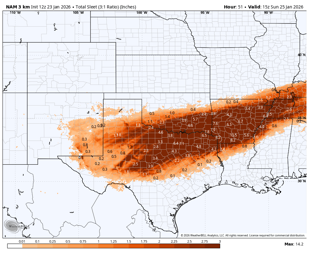
In any case, FW office is holding steady with mostly a FRZ RA and sleet event. They may be going conservative on the sleet totals, which is pretty common in these events. Better to be a little off in that direction than the other.
1 likes
-
Texas Snow
- S2K Supporter
- Posts: 813
- Joined: Mon Oct 19, 2015 12:06 pm
- Location: N. Dallas & Cedar Creek Lake
#4198 Postby Texas Snow » Fri Jan 23, 2026 10:37 am
I for one love the spirited debate, with evidence supporting different outcomes. Of course keep it civil but I think in general posts that everything is great or everything is dire never tell the full story. The screenshots with support only add to the value of the board. Thanks to everyone truly analyzing this.
4 likes
"Don't let wishcastin get in the way of your forecastin"
-
rwfromkansas
- Category 5
- Posts: 2906
- Joined: Sat Aug 27, 2005 12:47 am
- Location: North Fort Worth
#4200 Postby rwfromkansas » Fri Jan 23, 2026 10:41 am
Isn't this one that really goes into the NBM a lot, so it might bump things up there?
0 likes
Return to “Winter Weather”
Who is online
Users browsing this forum: bevolon, Bobbyh83, bohaiboy, Brandon8181, bubba hotep, Captmorg70, cheezyWXguy, chickypez, cmpcpa99, Cpv17, cstrunk, dfw_toadie, DFWLady, FamousOrangeCat, gboudx, Google Adsense [Bot], Gotwood, Haddox12, Harp.1, Iceresistance, iorange55, Ivanhater, JayDT, Longhornmaniac8, Marion Morrison, opticsguy, Ralph's Weather, rendihess, rwfromkansas, rylo7956, snownado, South Texas Storms, Stonewood Ranch, Stratton23, Tammie, TeamPlayersBlue, Texas Snow, ThunderSleetDreams, txtwister78, utpmg, wildbill, Will_TX, Winter_Wisher, wxman22, wxman57 and 398 guests


