Some snips from afternoon AFD's...
Midland/Odessa...
THERE ARE INDICATIONS
THAT AND ARCTIC AIR MASS WILL BEGIN TO MAKE ITS WAY INTO THE CENTRAL
UNITED STATES NEXT WEEKEND...AND PERHAPS REACH THE AREA BY MID NEXT
WEEK.
Dallas/Ft Worth...flip flop...
STILL APPEARS THAT THE A PATTERN SHIFT MAY ALLOW FOR SOME OF THE
COLDER AIR TO ARRIVE JUST IN TIME FOR THE THANKSGIVING HOLIDAY.
Texas Winter 2010-2011
Moderator: S2k Moderators
Forum rules
 The posts in this forum are NOT official forecast and should not be used as such. They are just the opinion of the poster and may or may not be backed by sound meteorological data. They are NOT endorsed by any professional institution or STORM2K.

The posts in this forum are NOT official forecast and should not be used as such. They are just the opinion of the poster and may or may not be backed by sound meteorological data. They are NOT endorsed by any professional institution or STORM2K.
-
srainhoutx

- S2K Supporter

- Posts: 6919
- Age: 68
- Joined: Sun Jan 14, 2007 11:34 am
- Location: Haywood County, NC
- Contact:
Re: Texas Winter 2010-2011
0 likes
Carla/Alicia/Jerry(In The Eye)/Michelle/Charley/Ivan/Dennis/Katrina/Rita/Wilma/Ike/Harvey
Member: National Weather Association
Wx Infinity Forums
http://wxinfinity.com/index.php
Facebook.com/WeatherInfinity
Twitter @WeatherInfinity
Member: National Weather Association
Wx Infinity Forums
http://wxinfinity.com/index.php
Facebook.com/WeatherInfinity
Twitter @WeatherInfinity
-
wall_cloud

- Professional-Met

- Posts: 401
- Age: 49
- Joined: Sun Dec 04, 2005 7:32 am
- Location: Bartlett, TN
- Contact:
I posted this on the other thread...
Temperatures in Canada are not incredibly cold yet and that is to be expected since we are still just in mid November. However, this pattern does depict a hint of cross-polar flow setting up by late week which could tap into some colder Siberian air. Both the ECMWF and GFS are showing a nice E-W oriented h5 trof axis across Canada with a strong anticyclone located over the Aleutians by 12z Thursday. This is reminiscent of the McFarland Signature that is used as a preliminary indicator of a cold air dump. Now the low that eventually will swing across the CONUS is progged to weaken with time evolving into more of an open wave as it crosses the Rockies early next week. The ECMWF does bring this trof farther south than the GFS which is reasonable depending on where the strongest baroclinic zone sets up.
That said, snow pack is meager to say the least across Canada and the prairie provinces may not have much at all by late week. The lack of snow pack combined with a higher sun angle than we'll see in a month will lead to quicker modification of any cold airmass that moves south. The cold air is likely to be more of a factor over the central/northern Plains ala the Dodge City AFD but sometimes these stronger airmasses move much farther south than anticipated. Its something to keep an eye on but its also not something that I'm overly excited about for my location in Texas.
0 likes
My comments are my own and do not reflect those of NOAA or the National Weather Service.
-
vbhoutex

- Storm2k Executive

- Posts: 29150
- Age: 74
- Joined: Wed Oct 09, 2002 11:31 pm
- Location: Cypress, TX
- Contact:
Re: Texas Winter 2010-2011
Very good point about the modification Wall Cloud. Sometimes when we look at the models we tend to forget the "real world" where there is no real snow cover to help the cold move further south without much modification. It really is still early in the season, at least in the South. I am wondering what this winter is really going to hold for us after the quirks we have seen in the Hurricane season. Just a weird year weather wise so far.
0 likes
Skywarn, C.E.R.T.
Please click below to donate to STORM2K to help with the expenses of keeping the site going:

Please click below to donate to STORM2K to help with the expenses of keeping the site going:
-
gboudx

- S2K Supporter
- Posts: 4090
- Joined: Thu Sep 04, 2003 1:39 pm
- Location: Rockwall, Tx but from Harvey, La
DFW NWS this morning.
If it "could be the coldest" so far this Fall, then that could mean the 1st areawide Freeze Warning. So for only the northern and western counties have had a Freeze Warning.
MODELS ARE STARTING SHOW A BIT MORE RUN TO RUN CONSISTENCY WITH
REGARDS TO THE POSSIBLE COLD AIR EARLY NEXT WEEK. IF PROGGED CORRECTLY...IT
DOES APPEAR THAT A STRONG COLD FRONT WILL MOVE ACROSS NORTH TEXAS
AROUND TUESDAY OF NEXT WEEK. IT IS WAY TOO EARLY TO TELL HOW COLD
IT WILL GET OR THE POSSIBLE IMPACTS...BUT IT COULD BE THE COLDEST
AIR NORTH TEXAS HAS SEEN THIS FALL.
If it "could be the coldest" so far this Fall, then that could mean the 1st areawide Freeze Warning. So for only the northern and western counties have had a Freeze Warning.
0 likes
-
Portastorm

- Storm2k Moderator

- Posts: 9955
- Age: 63
- Joined: Fri Jul 11, 2003 9:16 am
- Location: Round Rock, TX
- Contact:
Re: Texas Winter 2010-2011
You know what I find odd about that snippet from DFW? As I see it, the GFS isn't showing much consistency. In fact, today's 0z run backs way off from a cold air intrusion into the Southern Plains by Thanksgiving. The European still shows a cold front around 216-240 hours but takes the bulk of the coldest air to the Great Lakes and East Coast and not a direct shot down into the Southern Plains.
BTW, thanks wall_cloud for the great discussion about source regions and sun angles. Makes us all smarter (I hope!).
BTW, thanks wall_cloud for the great discussion about source regions and sun angles. Makes us all smarter (I hope!).
0 likes
-
HockeyTx82
- S2K Supporter
- Posts: 2813
- Joined: Tue Oct 27, 2009 11:17 am
- Location: Ponder, TX
Re: Texas Winter 2010-2011
For what's worth the local met on FOX 4 this moring mentioned the cold air next week twice in his forecast so he seems to be buying into it. Anyone else hear anything from the other local TV mets? I know that Steve McCauley on Ch 8 likes to talk about these kind of things but I have not been able to watch him of late.
And wall_cloud thank you for all your input.
And wall_cloud thank you for all your input.
0 likes
Don't hold me accountable for anything I post on this forum. Leave the real forecasting up to the professionals.
Location: Ponder, TX (all observation posts are this location unless otherwise noted)
Location: Ponder, TX (all observation posts are this location unless otherwise noted)
-
srainhoutx
- S2K Supporter
- Posts: 6919
- Age: 68
- Joined: Sun Jan 14, 2007 11:34 am
- Location: Haywood County, NC
- Contact:
Re: Texas Winter 2010-2011
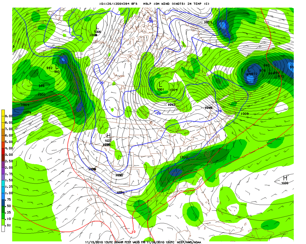
The 12Z GFS suggests the Arctic Front may be a bit slower arriving, but a very chilly 1040mb+ dome of Arctic High Pressure is depicted dropping S into the Plains. With that said, I believe the models will struggle with the shallow nature of the Arctic Air and the front may infact arrive sooner that it's showing at this range...
0 likes
Carla/Alicia/Jerry(In The Eye)/Michelle/Charley/Ivan/Dennis/Katrina/Rita/Wilma/Ike/Harvey
Member: National Weather Association
Wx Infinity Forums
http://wxinfinity.com/index.php
Facebook.com/WeatherInfinity
Twitter @WeatherInfinity
Member: National Weather Association
Wx Infinity Forums
http://wxinfinity.com/index.php
Facebook.com/WeatherInfinity
Twitter @WeatherInfinity

Re: Texas Winter 2010-2011
Great discussion on the possible Arctic front. My small mind is wondering if weather models will ever evolve to the the point that they can deal with winter better more consistently.
Models always struggle with shallow air. I hope eventually......technology will catch up with old man winter.
Models always struggle with shallow air. I hope eventually......technology will catch up with old man winter.
0 likes
-
CaptinCrunch

- S2K Supporter
- Posts: 8783
- Age: 58
- Joined: Mon Nov 03, 2003 4:33 pm
- Location: Kennedale, TX (Tarrant Co.)
Re: Texas Winter 2010-2011
Not too sure about Thanksgiving, but look for something early Dec for sure! 
0 likes
-
wxman57

- Moderator-Pro Met

- Posts: 23175
- Age: 68
- Joined: Sat Jun 21, 2003 8:06 pm
- Location: Houston, TX (southwest)
Re: Texas Winter 2010-2011
I made a couple of meteograms for IAH and DFW. By the way, I have also created a tutorial for how to make these meteograms. If any of you are interested in making your own, I can post the tutorial and the 2 spreadsheets I use. It will require Microsoft Excel 2007.
Note that the extended GFS plots below have ONLY the 6am and 6PM CST temperatures. That means you may need to add 5-7 degrees to the 6pm temp to get the high for the day (assuming sunshine). Pretty cold air arriving around Thanksgiving, but I don't see any post-frontal precip.
First, Houston:

Now Dallas:

Note that the extended GFS plots below have ONLY the 6am and 6PM CST temperatures. That means you may need to add 5-7 degrees to the 6pm temp to get the high for the day (assuming sunshine). Pretty cold air arriving around Thanksgiving, but I don't see any post-frontal precip.
First, Houston:
Now Dallas:
0 likes
-
srainhoutx
- S2K Supporter
- Posts: 6919
- Age: 68
- Joined: Sun Jan 14, 2007 11:34 am
- Location: Haywood County, NC
- Contact:
Re: Texas Winter 2010-2011
What I find interesting is the development of a Coastal Low after the Thanksgiving front. Although this is La La Land in GFS world, the temps posted in wxman57's meteogram would appear that a very chilly rain may be ahead with a reinforcing shot of cold air. Just looking at trends at this range. 
0 likes
Carla/Alicia/Jerry(In The Eye)/Michelle/Charley/Ivan/Dennis/Katrina/Rita/Wilma/Ike/Harvey
Member: National Weather Association
Wx Infinity Forums
http://wxinfinity.com/index.php
Facebook.com/WeatherInfinity
Twitter @WeatherInfinity
Member: National Weather Association
Wx Infinity Forums
http://wxinfinity.com/index.php
Facebook.com/WeatherInfinity
Twitter @WeatherInfinity
-
wxman57
- Moderator-Pro Met
- Posts: 23175
- Age: 68
- Joined: Sat Jun 21, 2003 8:06 pm
- Location: Houston, TX (southwest)
Re: Texas Winter 2010-2011
By the way, I did create a post with links to my meteogram tutorial and all files needed. I made it a "sticky".
0 likes
-
srainhoutx
- S2K Supporter
- Posts: 6919
- Age: 68
- Joined: Sun Jan 14, 2007 11:34 am
- Location: Haywood County, NC
- Contact:
Re: Texas Winter 2010-2011
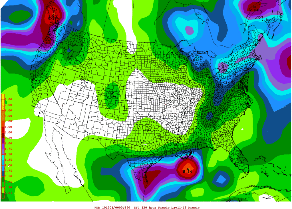
Also of note is the AO daily charts. Notice the sharp drop projected. Fits nicely with what we are seeing in the Operational Models...

0 likes
Carla/Alicia/Jerry(In The Eye)/Michelle/Charley/Ivan/Dennis/Katrina/Rita/Wilma/Ike/Harvey
Member: National Weather Association
Wx Infinity Forums
http://wxinfinity.com/index.php
Facebook.com/WeatherInfinity
Twitter @WeatherInfinity
Member: National Weather Association
Wx Infinity Forums
http://wxinfinity.com/index.php
Facebook.com/WeatherInfinity
Twitter @WeatherInfinity
Re: Texas Winter 2010-2011
From the San Angelo Forecast Discussion this afternoon:
Main story is beyond this forecast...for the potential for a strong
cold front late Wednesday next week... bringing a significant cool
down on Thanksgiving... and perhaps a chance of showers with lift
over and behind front. Being on days 8 and 9 there is not a lot of
confidence...however both the GFS and ec models have a similar
solution.
0 likes
-
TeamPlayersBlue

- Category 5

- Posts: 3533
- Joined: Tue Feb 02, 2010 1:44 am
- Location: Denver/Applewood, CO
Models continue to flip flop and say the cold air will come at the 240hr. I already lost a bet on this arctic front so i'll take it seriously when it shows it within day6 or 7  Either way im excited. Hoping the snow pack in southern Canada can build up a bit so we dont have too much moderation This is a cold air mass that can bring some interesting weather down here....
0 likes
Personal Forecast Disclaimer:
The posts in this forum are NOT official forecast and should not be used as such. They are just the opinion of the poster and may or may not be backed by sound meteorological data. They are NOT endorsed by any professional institution or storm2k.org. For official information, please refer to the NHC and NWS products.
The posts in this forum are NOT official forecast and should not be used as such. They are just the opinion of the poster and may or may not be backed by sound meteorological data. They are NOT endorsed by any professional institution or storm2k.org. For official information, please refer to the NHC and NWS products.
-
Texas2Florida
- Tropical Depression

- Posts: 71
- Joined: Thu Dec 03, 2009 12:17 am
- Location: NE Pennsylvania backwoods
So is there a chance of frozen precip around Thanksgiving or what? I'm seeing cold front/arctic air chatter in one post along with "showers with lift" from another. I'd love to know as I work in the travel industry, and that will definitely let me know how my week will go.
0 likes
Real women wear firesuits! --self proclaimed NASCAR princess.

Re:
Texas2Florida wrote:So is there a chance of frozen precip around Thanksgiving or what? I'm seeing cold front/arctic air chatter in one post along with "showers with lift" from another. I'd love to know as I work in the travel industry, and that will definitely let me know how my week will go.
If there is precip it will likely be a chilly rain. What the shifts are is when will the cold air finally arrive. The models are keying in on Thanksgivings day plus or minus a day (some show 30s, 40s for highs while other have warm 70s). If there is 'wintry' precip for TG it will probably be confined to the panhandles and Kansas on northward. Too early to call for certain...as for the southern zones, severe weather is always a possibility when you have opposite air masses clashing which is exactly what this pattern is setting up to be.
0 likes
The above post and any post by Ntxw is NOT an official forecast and should not be used as such. It is just the opinion of the poster and may or may not be backed by sound meteorological data. It is NOT endorsed by any professional institution including Storm2k. For official information, please refer to NWS products.
Help support Storm2K!
Re: Texas Winter 2010-2011
Latest from San Angelo NWS:
THE BIG CHANGE LOOKS
TO BE ON WEDNESDAY AS AN OUTBREAK OF POLAR AIR DROPS SOUTH INTO
TEXAS WITH A POLAR FRONTAL PASSAGE FORECASTED DURING THE DAY
WEDNESDAY. IF THIS FORECAST HOLDS...WE SHOULD SEE THE COLDEST
TEMPERATURES OF THE SEASON BY THURSDAY MORNING.
DRY FORECAST WILL CONTINUE OVER THE FORECAST AREA AS MID LEVEL
MOISTURE REMAINS RATHER ANEMIC.
0 likes
Re: Texas Winter 2010-2011
FW discussion this afternoon.
HGX
AFD
Looks like we're having cold turkey this year.
AS FOR THE COLD FRONT ARRIVING MID NEXT WEEK. TIMING IS HARD TO
PIN DOWN AT THE MOMENT...BUT SHOULD BECOME MORE CLEAR BY THE
BEGINNING OF THE NEXT WORK WEEK. THE AIRMASS WILL ORIGINATE AS A
COMBINATION OF ALASKAN AND NORTHERN CANADIAN AIR...WHICH IS
CURRENTLY RUNNING IN THE TEENS AND SINGLE DIGITS. OUR
EXPERIENCE...AND DETERMINISTIC MODEL BIAS WITH ARCTIC AIR
MASSES...INDICATE THAT THE ARCTIC FRONT WILL ARRIVE FASTER AND BE
COLDER THAN CURRENT GUIDANCE INDICATES. FOR THESE REASONS...WE/VE
DECIDED TO BRING THE ARCTIC FRONT THROUGH EARLY WEDNESDAY
FOLLOWING THE GFS TIMING...AND USE THE ECMWF THERMO PROFILE FOR
SURFACE TEMPERATURES AND WINDS ON THANKSGIVING DAY AND FRIDAY. WE
WILL ALSO LIMIT DIURNAL TEMP CHANGES BOTH DAYS WITH OVERNIGHT LOWS
FALLING INTO THE MID 20S TO LOWER/MID 30S...AND HIGHS ONLY IN THE
MID 40S TO MID 50S ON THURSDAY AND 50S ON FRIDAY. A WIDESPREAD
FREEZE IS EXPECTED ACROSS MUCH OF THE CWA BOTH MORNINGS.
SINCE THIS EVENT IS STILL A WAYS OUT...OUR CONFIDENCE IN
WEDNESDAYS FRONTAL TIMING IS MODERATE AT BEST AS IT COULD ARRIVE
TUESDAY NIGHT OR HANG UP UNTIL WEDNESDAY EVENING. AS FOR
TEMPERATURES BEHIND THE FRONT...OUR CONFIDENCE IS MUCH HIGHER THAT
THE AIR MASS WILL BE VERY COLD AND DENSE WHEN IT DOES ARRIVE. 75
HGX
GFS/ECMWF DIFFER A BIT WITH TIMING ON THE NEXT
COLD FRONT. THE GFS IS FASTER AND BRINGS THE FRONT THROUGH
WEDNESDAY EVENING WHILE THE ECMWF BRINGS THE COLD FRONT THROUGH
SOUTHEAST TEXAS THURSDAY MORNING. THE FRONT WILL TRIGGER SHOWERS
AS IT CROSSES THE AREA. PW VALUES INCREASE TO AROUND 1.5 INCHES BY
WEDNESDAY AFTERNOON. SOUTHEAST TEXAS WILL ALSO LIE IN A RIGHT REAR
QUAD OF A DEPARTING JET. HOWEVER...FORECAST SOUNDINGS SHOW A PESKY
CAP REMAINING IN PLACE SO CONFIDENCE IS LOW ON PRECIP COVERAGE.
LONG RANGE MODELS IN GOOD AGREEMENT WITH CLEARING BEHIND THE FRONT
AND CONSIDERABLY COLDER TEMPERATURES MOVING INTO THE REGION. LOWS
NEAR FREEZING WILL BE POSSIBLE BY NEXT FRIDAY MORNING. 43
AFD
FOR TUESDAY THROUGH THURSDAY (THANKSGIVING), MODELS CONTINUE THEIR
LACK OF CONSISTENCY AND CONSENSUS. A LEAD SHORT-WAVE LIFTS OUT OF
THE WESTERN STATES UPPER TROUGH ON TUESDAY AND MOVES ACROSS THE
PLAINS WITH THE MAIN UPPER TROUGH ON THURSDAY. SOME MODELS DRAG A
PACIFIC FRONT OR DRYLINE INTO SOUTH CENTRAL TEXAS ON TUESDAY WITH
OTHERS KEEP IT WEST OR MOVE IT BACK WEST AFTER A BRIEF INTRUSION
INTO SOUTH CENTRAL TEXAS. ALL MODELS SHOW A STRONG COLD FRONTAL
PASSAGE EITHER WEDNESDAY OR WEDNESDAY NIGHT. FOR NOW, WILL
DISREGARD THE TUESDAY FRONT/DRYLINE AS THESE ARE OUTLIERS AND
EXPECT THE STRONG COLD FRONT TO MOVE THROUGH ON WEDNESDAY. WILL
CONTINUE WITH SLIGHT TO LOW END CHANCES FOR SHOWERS TUESDAY INTO
WEDNESDAY EVENING. THERE MAY BE SUFFICIENT MOISTURE DEPTH AND
CONVERGENCE ALONG THE FRONT AS WELL AS SOME CAPE (1K TO 1.5K J/KG)
FOR ISOLATED LIGHTNING STRIKES AND ASSOCIATED THUNDER WEDNESDAY.
THANKSGIVING LOOKS TO BE COLD AND HAVE GONE MUCH COLDER THAN
GUIDANCE TEMPERATURES. THERE MAY BE A HARD FREEZE ACROSS PARTS OF
SOUTH CENTRAL TEXAS THE FRIDAY MORNING AFTER THANKSGIVING.
Looks like we're having cold turkey this year.
0 likes
The above post and any post by Ntxw is NOT an official forecast and should not be used as such. It is just the opinion of the poster and may or may not be backed by sound meteorological data. It is NOT endorsed by any professional institution including Storm2k. For official information, please refer to NWS products.
Help support Storm2K!
Help support Storm2K!
Who is online
Users browsing this forum: No registered users and 120 guests