
NAM: Go to sleet. Go directly to sleet. Do not pass "snow". Do not collect snow shovel.
At least for DFW
Texas Winter 2025-2026
Moderator: S2k Moderators
Forum rules
 The posts in this forum are NOT official forecast and should not be used as such. They are just the opinion of the poster and may or may not be backed by sound meteorological data. They are NOT endorsed by any professional institution or STORM2K.

The posts in this forum are NOT official forecast and should not be used as such. They are just the opinion of the poster and may or may not be backed by sound meteorological data. They are NOT endorsed by any professional institution or STORM2K.
Re: Texas Winter 2025-2026
1 likes
Re: Texas Winter 2025-2026
Ntxw wrote:MJO has crossed into P7, it will slow and loop a bit, which is why we're looking at another reinforcing cold shot late next week. Looks like after a quick passage of 8 it will go into P1-2.
https://i.imgur.com/GtEBYwZ.png
Get it to P2 in Nina February.
https://i.imgur.com/R7VTEQj.png
My body is ready my electricity meter isn’t lol.
3 likes
-
CaptinCrunch

- S2K Supporter

- Posts: 8767
- Age: 57
- Joined: Mon Nov 03, 2003 4:33 pm
- Location: Kennedale, TX (Tarrant Co.)
Re: Texas Winter 2025-2026
Timing of surface front is faster that forecast, The surface front went through Broken Bow NE @ 1:53pm with a N wind 8 mph gusting to 20 mph, @ 2:53pm winds were N @ 16 mph with a temp of 30F at the regional airport.
Calculating the distance to the Air port from our office building in DT FTW is 550 miles / 20 mph frontal movement = 27.5 hrs till it impacts DT FTW.
That puts the surface front into DFW by 7:30pm Friday followed by the arctic wall and the white walkers @ 9:30pm. Which means we could be seeing the onset of FR precip before midnight.
So there's' that......
7 likes
-
LearnedHat
- Tropical Depression

- Posts: 93
- Joined: Wed Feb 10, 2010 11:17 am
- Location: Keller, TX
Re: Texas Winter 2025-2026
CaptinCrunch wrote:Timing of surface front is faster that forecast, The surface front went through Broken Bow NE @ 1:53pm with a N wind 8 mph gusting to 20 mph, @ 2:53pm winds were N @ 16 mph with a temp of 30F at the regional airport.
Calculating the distance to the Air port from our office building in DT FTW is 550 miles / 20 mph frontal movement = 27.5 hrs till it impacts DT FTW.
That puts the surface front into DFW by 7:30pm Friday followed by the arctic wall and the white walkers @ 9:30pm. Which means we could be seeing the onset of FR precip before midnight.
So there's' that......
Do these air masses usually gain or lose speed as they go?
0 likes
Re: Texas Winter 2025-2026
https://youtu.be/J3u3731eGTM?si=5bg8hC7ygXLB3bPe
It's go time folks
It's go time folks
1 likes
-
CaptinCrunch
- S2K Supporter
- Posts: 8767
- Age: 57
- Joined: Mon Nov 03, 2003 4:33 pm
- Location: Kennedale, TX (Tarrant Co.)
Re: Texas Winter 2025-2026
LearnedHat wrote:CaptinCrunch wrote:Timing of surface front is faster that forecast, The surface front went through Broken Bow NE @ 1:53pm with a N wind 8 mph gusting to 20 mph, @ 2:53pm winds were N @ 16 mph with a temp of 30F at the regional airport.
Calculating the distance to the Air port from our office building in DT FTW is 550 miles / 20 mph frontal movement = 27.5 hrs till it impacts DT FTW.
That puts the surface front into DFW by 7:30pm Friday followed by the arctic wall and the white walkers @ 9:30pm. Which means we could be seeing the onset of FR precip before midnight.
So there's' that......
Do these air masses usually gain or lose speed as they go?
could be a little of both when factoring in the topography of the land
2 likes
-
rwfromkansas
- Category 5

- Posts: 2923
- Joined: Sat Aug 27, 2005 12:47 am
- Location: North Fort Worth
Re: Texas Winter 2025-2026
Ntxw wrote:Gotwood wrote:Ntxw wrote:
Yeah ignoring snow and ice, get DFW into single digits and it's etched in analogs forever up here in terms of Arctic blasts.
At what point do we consider the possibility of a prolonged freezing event here? I mean the GFS has been kinda hinting at it some. This 12z run is absolutely wild temps not getting above 35 until Feb 5th for Metroplex?
It could extend through to mid Feb not the subfreezing but well below normal. Not a full calendar month but I would not be shocked if 3-4 weeks of sub 40F average which we haven't done since 2000. Sub-40F are the legendary cold months of old 1978, 1983, 1985, 1989 etc.
How does the extended freeze change calculations for mid-February cold if we don't warm up? Does it make any difference even?
0 likes


Re: Texas Winter 2025-2026
We are getting closer with the GFS (for a Sunday snow day) just trend it a little more south and east.

3 likes
The above post and any post by Ntxw is NOT an official forecast and should not be used as such. It is just the opinion of the poster and may or may not be backed by sound meteorological data. It is NOT endorsed by any professional institution including Storm2k. For official information, please refer to NWS products.
Help support Storm2K!
-
Stratton23
- Category 5
- Posts: 3384
- Joined: Fri Jul 21, 2023 10:59 pm
- Location: Katy, Tx
Re: Texas Winter 2025-2026
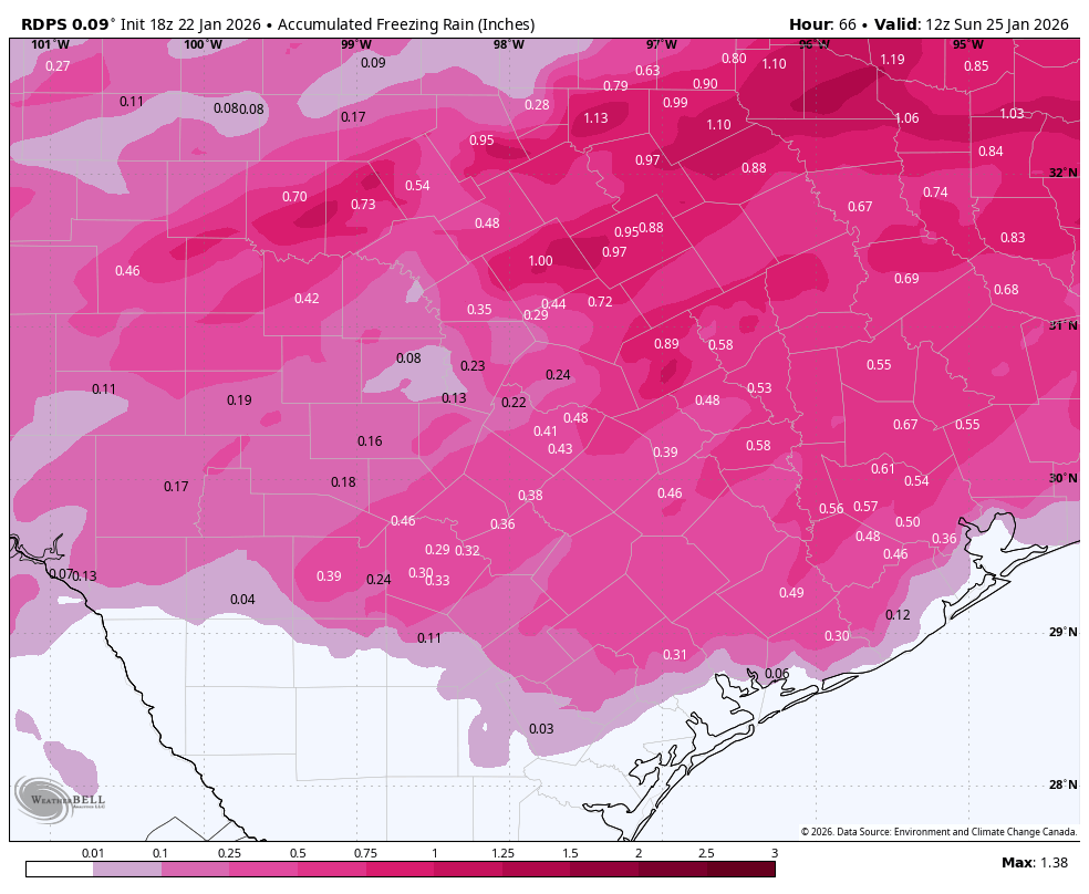
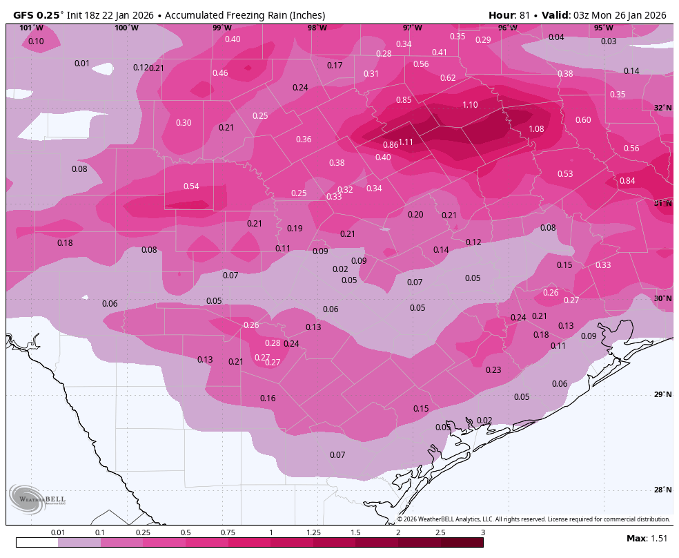
18z GFS us a lot more aggressive with freezing rain in the houston metro, yikes
0 likes
Re: Texas Winter 2025-2026
rwfromkansas wrote:How does the extended freeze change calculations for mid-February cold if we don't warm up? Does it make any difference even?
I don't think so. But if lower heights prevail in the upcoming pattern, and surface already cold probably easier to have all snow events.
4 likes
The above post and any post by Ntxw is NOT an official forecast and should not be used as such. It is just the opinion of the poster and may or may not be backed by sound meteorological data. It is NOT endorsed by any professional institution including Storm2k. For official information, please refer to NWS products.
Help support Storm2K!
Help support Storm2K!
-
CaptinCrunch
- S2K Supporter
- Posts: 8767
- Age: 57
- Joined: Mon Nov 03, 2003 4:33 pm
- Location: Kennedale, TX (Tarrant Co.)
Re: Texas Winter 2025-2026
Ntxw wrote:We are getting closer with the GFS (for a Sunday snow day) just trend it a little more south and east.
https://i.imgur.com/DlOza07.gif
I thing it will trend in that direction, will not be surprised for tomorrow morning models showing a slightly further south bulls eye.
3 likes
-
LearnedHat
- Tropical Depression
- Posts: 93
- Joined: Wed Feb 10, 2010 11:17 am
- Location: Keller, TX
Re: Texas Winter 2025-2026
CaptinCrunch wrote:Ntxw wrote:We are getting closer with the GFS (for a Sunday snow day) just trend it a little more south and east.
https://i.imgur.com/DlOza07.gif
I thing it will trend in that direction, will not be surprised for tomorrow morning models showing a slightly further south bulls eye.
Is the trajectory of the moisture changing or is it still the timing of the Arctic front?
0 likes
-
downsouthman1
- Category 2

- Posts: 687
- Age: 46
- Joined: Fri Jan 07, 2011 8:14 pm
- Location: Rowlett, TX
Re: Texas Winter 2025-2026
LearnedHat wrote:CaptinCrunch wrote:Ntxw wrote:We are getting closer with the GFS (for a Sunday snow day) just trend it a little more south and east.
https://i.imgur.com/DlOza07.gif
I thing it will trend in that direction, will not be surprised for tomorrow morning models showing a slightly further south bulls eye.
Is the trajectory of the moisture changing or is it still the timing of the Arctic front?
Everything is changing all the time.
1 likes
Not a professional MET! My posts are merely speculation.
-
LearnedHat
- Tropical Depression
- Posts: 93
- Joined: Wed Feb 10, 2010 11:17 am
- Location: Keller, TX
Re: Texas Winter 2025-2026
downsouthman1 wrote:LearnedHat wrote:CaptinCrunch wrote:
I thing it will trend in that direction, will not be surprised for tomorrow morning models showing a slightly further south bulls eye.
Is the trajectory of the moisture changing or is it still the timing of the Arctic front?
Everything is changing all the time.
I understand, just wondering about the primary catalyst bringing about the Captin's thoughts on changing model outputs.
0 likes
-
txtwister78

- Category 5
- Posts: 2083
- Joined: Wed Jan 30, 2019 12:56 pm
- Location: San Antonio
Re: Texas Winter 2025-2026
You can definitely see where these trends are headed with Euro likely late to the party regarding surface temps as usual.
Unfortunately not great news for SA metro.
Unfortunately not great news for SA metro.
2 likes

Re: Texas Winter 2025-2026
downsouthman1 wrote:LearnedHat wrote:CaptinCrunch wrote:
I thing it will trend in that direction, will not be surprised for tomorrow morning models showing a slightly further south bulls eye.
Is the trajectory of the moisture changing or is it still the timing of the Arctic front?
Everything is changing all the time.
Changed from this morning that's for sure
0 likes
Personal Forecast Disclaimer:
The posts in this forum are NOT official forecast and should not be used as such. They are just the opinion of the poster and may or may not be backed by sound meteorological data. They are NOT endorsed by any professional institution or storm2k.org. For official information, please refer to the NHC and NWS products.
The posts in this forum are NOT official forecast and should not be used as such. They are just the opinion of the poster and may or may not be backed by sound meteorological data. They are NOT endorsed by any professional institution or storm2k.org. For official information, please refer to the NHC and NWS products.
-
txtwister78
- Category 5
- Posts: 2083
- Joined: Wed Jan 30, 2019 12:56 pm
- Location: San Antonio
-
UTSARoadrunner4
- Category 1

- Posts: 258
- Age: 29
- Joined: Wed Aug 26, 2020 11:19 pm
Re: Texas Winter 2025-2026
OOHHHH NOOOOO!!!
Good thing TXDOT is already out spraying roads around San Antonio.
0 likes
-
hurricane2025
- Category 1
- Posts: 254
- Joined: Thu Apr 08, 2021 10:36 am
-
rwfromkansas
- Category 5
- Posts: 2923
- Joined: Sat Aug 27, 2005 12:47 am
- Location: North Fort Worth
Re: Texas Winter 2025-2026
The FWD experimental forecast went from 1 to 2 for snow, so that's something. Not the same as the main page official one (though it seems to basically match it well at this time).
Last edited by rwfromkansas on Thu Jan 22, 2026 5:34 pm, edited 1 time in total.
1 likes
Who is online
Users browsing this forum: Brazoria979cnty, Coldandsnow, ColdFusion, cstrunk, DallasAg, DonWrk, drewser, Gotwood, HockeyTx82, Nrthfwsnoww, Ntxw, Oilman89, orangeblood, snownado, steviegcomeback, Tejas89, TexasF6, utpmg and 250 guests