Southern Plains winter wx thread (2008-2009)

Winter Weather Discussion

Moderator: S2k Moderators

Forum rules

The posts in this forum are NOT official forecast and should not be used as such. They are just the opinion of the poster and may or may not be backed by sound meteorological data. They are NOT endorsed by any professional institution or STORM2K.

Help Support Storm2K
Message
Author
User avatar
Extremeweatherguy
Category 5
Category 5
Posts: 11095
Joined: Mon Oct 10, 2005 8:13 pm
Location: Florida

#341 Postby Extremeweatherguy » Mon Dec 08, 2008 12:49 am

boca wrote:Will Florida get into the cold air action too?


I think initially the cold will be centered more toward the west and the plains, but it may eventually try to migrate east after the 20th. Truthfully, I wouldn't be surprised at all if the southeast (including Florida) experienced a colder-than-normal Christmas holiday this year.
0 likes   

User avatar
MGC
S2K Supporter
S2K Supporter
Posts: 5899
Joined: Sun Mar 23, 2003 9:05 pm
Location: Pass Christian MS, or what is left.

Re: Cold pattern on the way?

#342 Postby MGC » Mon Dec 08, 2008 12:53 am

Lack of significant snow pack will likely allow any Artic air to modify before it reach the deep deep south.....MGC
0 likes   

User avatar
somethingfunny
ChatStaff
ChatStaff
Posts: 3926
Age: 37
Joined: Thu May 31, 2007 10:30 pm
Location: McKinney, Texas

Re: Cold pattern on the way?

#343 Postby somethingfunny » Mon Dec 08, 2008 7:39 am

Getting close to crunch time.....

Will precipitation form behind the cold front? Will there be enough rainwater on the roads to make DFW a skating rink Tuesday morning? The local news doesn't seem to be aware of either possibility.
0 likes   

User avatar
Extremeweatherguy
Category 5
Category 5
Posts: 11095
Joined: Mon Oct 10, 2005 8:13 pm
Location: Florida

#344 Postby Extremeweatherguy » Mon Dec 08, 2008 9:18 am

The 6z GFS may be starting to catch on. It is showing a 1055mb high pressure area coming out of Canada in about 180 hours and is pushing an arctic front through the plains...

http://www.nco.ncep.noaa.gov/pmb/nwprod ... n_180l.gif

...After this arctic front passes through, it sets up a pretty nice winter weather event over Oklahoma for next week.
0 likes   

User avatar
Extremeweatherguy
Category 5
Category 5
Posts: 11095
Joined: Mon Oct 10, 2005 8:13 pm
Location: Florida

#345 Postby Extremeweatherguy » Mon Dec 08, 2008 9:26 am

In the shorter term, the 12z NAM now looks wetter for tomorrow across Oklahoma. This means that I might wind up seeing a little more snow than I first thought. If the NAM is right, then I will probably see more than the light dusting that is currently forecast. Might even be able to squeeze out a quick inch or two across central Oklahoma if the snow band really sets up like this...

http://www.nco.ncep.noaa.gov/pmb/nwprod ... p_036l.gif

http://www.nco.ncep.noaa.gov/pmb/nwprod ... p_042l.gif

Pretty exciting!
0 likes   

jinftl
Category 5
Category 5
Posts: 4312
Joined: Tue Aug 31, 2004 4:47 pm
Location: fort lauderdale, fl

Re:

#346 Postby jinftl » Mon Dec 08, 2008 10:46 am

As others have said, it depends on what you define as cold....many down here have considered this to be a cool/cold weather pattern already.

That said, is there a chance that a major freeze event could happen this winter in florida? Not out of the question....but not in the forecast right now for at least for the next week or 2. Will Miami see 20 days in a row this winter of high temps below 65 and low temps under 40. No. Did that happen in any of the landmark winters being referred to (1980, 1983, 1989)? No. Has that ever happened? No. So it all comes down to the same question...how do you define cold.

Extremeweatherguy wrote:
boca wrote:Will Florida get into the cold air action too?


I think initially the cold will be centered more toward the west and the plains, but it may eventually try to migrate east after the 20th. Truthfully, I wouldn't be surprised at all if the southeast (including Florida) experienced a colder-than-normal Christmas holiday this year.
0 likes   

User avatar
Extremeweatherguy
Category 5
Category 5
Posts: 11095
Joined: Mon Oct 10, 2005 8:13 pm
Location: Florida

Re: Re:

#347 Postby Extremeweatherguy » Mon Dec 08, 2008 10:51 am

jinftl wrote:As others have said, it depends on what you define as cold....many down here have considered this to be a cool/cold weather pattern already.

That said, is there a chance that a major freeze event could happen this winter in florida? Not out of the question....but not in the forecast right now for at least for the next week or 2. Will Miami see 20 days in a row this winter of high temps below 65 and low temps under 40. No. Did that happen in any of the landmark winters being referred to (1980, 1983, 1989)? No. Has that ever happened? No. So it all comes down to the same question...how do you define cold.

Extremeweatherguy wrote:
boca wrote:Will Florida get into the cold air action too?


I think initially the cold will be centered more toward the west and the plains, but it may eventually try to migrate east after the 20th. Truthfully, I wouldn't be surprised at all if the southeast (including Florida) experienced a colder-than-normal Christmas holiday this year.
My definition of cold for Florida would be this:

(At least 2 out of 5 of these events must occur)

1) A high temperature below 40F in Tallahassee and/or a low below 20F

2) A high temperature below 50F in Orlando and/or a low below 32F.

3) A high temperature below 60F in Miami and/or a low below 40F.

4) Widespread reports of snow, sleet and/or freezing rain

3) A stretch of 5 or more days with most of the state remaining at least 7 degrees below average.
0 likes   

jinftl
Category 5
Category 5
Posts: 4312
Joined: Tue Aug 31, 2004 4:47 pm
Location: fort lauderdale, fl

Re: Re:

#348 Postby jinftl » Mon Dec 08, 2008 1:04 pm

By your definition, 'cold' not in the forecast in the forseeable future....outlook for the next 2 weeks is generally normal to above normal temps. I totally think your definition of 'cold' is very on-point for what the 'relative' concept of cold in florida can be considered.


Extremeweatherguy wrote:
My definition of cold for Florida would be this:

(At least 2 out of 5 of these events must occur)

1) A high temperature below 40F in Tallahassee and/or a low below 20F

2) A high temperature below 50F in Orlando and/or a low below 32F.

3) A high temperature below 60F in Miami and/or a low below 40F.

4) Widespread reports of snow, sleet and/or freezing rain

3) A stretch of 5 or more days with most of the state remaining at least 7 degrees below average.
0 likes   

Brent
S2K Supporter
S2K Supporter
Posts: 38089
Age: 36
Joined: Sun May 16, 2004 10:30 pm
Location: Tulsa Oklahoma
Contact:

Re: Re:

#349 Postby Brent » Mon Dec 08, 2008 1:14 pm

jinftl wrote:By your definition, 'cold' not in the forecast in the forseeable future....outlook for the next 2 weeks is generally normal to above normal temps. I totally think your definition of 'cold' is very on-point for what the 'relative' concept of cold in florida can be considered.


Extremeweatherguy wrote:
My definition of cold for Florida would be this:

(At least 2 out of 5 of these events must occur)

1) A high temperature below 40F in Tallahassee and/or a low below 20F

2) A high temperature below 50F in Orlando and/or a low below 32F.

3) A high temperature below 60F in Miami and/or a low below 40F.

4) Widespread reports of snow, sleet and/or freezing rain

3) A stretch of 5 or more days with most of the state remaining at least 7 degrees below average.


I agree, that's what I would consider cold in Florida as well, and I do not see it. This weekend and early next week especially looks much warmer than it has been the last 2 weeks.
0 likes   

JonathanBelles
Professional-Met
Professional-Met
Posts: 11430
Age: 35
Joined: Sat Dec 24, 2005 9:00 pm
Location: School: Florida State University (Tallahassee, FL) Home: St. Petersburg, Florida
Contact:

#350 Postby JonathanBelles » Mon Dec 08, 2008 1:16 pm

Tuesday we are going for close to 80 here! :grr:
0 likes   

Ed Mahmoud

Re: Cold pattern on the way?

#351 Postby Ed Mahmoud » Mon Dec 08, 2008 2:08 pm

Gotta dig the way the Euro packs the 850 mb level isotherms in a week...


Image
0 likes   

jinftl
Category 5
Category 5
Posts: 4312
Joined: Tue Aug 31, 2004 4:47 pm
Location: fort lauderdale, fl

Re: Cold pattern on the way?

#352 Postby jinftl » Mon Dec 08, 2008 2:33 pm

From NWS Phoenix

AREA FORECAST DISCUSSION
NATIONAL WEATHER SERVICE PHOENIX AZ
950 AM MST MON DEC 8 2008

.SYNOPSIS...
BIG CHANGES EXPECTED BY THE WEEKEND IN THE H5 PATTERN. MODELS
/GFS-ECMWF-GENS/ HAVE BEEN VERY CONSISTENT OVER THE PAST SEVERAL
DAYS IN SHOWING THE DEVELOPMENT OF A H5 LONGWAVE TROUGH OVER THE
WEST COAST BY THE WEEKEND. IN FACT THE PAST 10 RUNS OF THE GFS HAVE
HAD A FAIRLY SIMILAR SOLUTION...SO THERE IS DEFINITELY GROWING
CONFIDENCE OF A SHIFT IN THE WEATHER.
OBVIOUSLY IT IS HARD TO
PIN-DOWN THE DETAILS THIS MANY DAYS OUT...BUT HAVE OPTED /IN
COORDINATION WITH SURROUNDING WFOS/ TO BE MORE AGGRESSIVE WITH THE
FORECAST. HAVE INCREASED POPS TO ABOUT TWICE THE CLIMO VALUES FROM
SATURDAY NIGHT ONWARD...BROUGHT TEMPS DOWN AND INCREASED CLOUD
COVER. LATEST GFS LOOKED TOO COOL BUT EVEN USING THE WARMER ECMWF
MASS FIELDS WE COULD SEE SOME SNOW IN THE HIGHER ELEVATIONS OF OUR
CWA LATER IN THE STORM SYSTEM. OBVIOUSLY BEARS WATCHING AS THIS
COULD BE A DECENT...POSSIBLY PRO-LONGED...PRECIP EVENT FOR MAINLY
OUR EASTERN CWA.
0 likes   

User avatar
Extremeweatherguy
Category 5
Category 5
Posts: 11095
Joined: Mon Oct 10, 2005 8:13 pm
Location: Florida

#353 Postby Extremeweatherguy » Mon Dec 08, 2008 2:44 pm

It is almost 70F here today! :eek: Hard to believe that 24 hours from now we will be hovering in the 30s with wind and snow!
0 likes   

Brent
S2K Supporter
S2K Supporter
Posts: 38089
Age: 36
Joined: Sun May 16, 2004 10:30 pm
Location: Tulsa Oklahoma
Contact:

Re: Cold pattern on the way?

#354 Postby Brent » Mon Dec 08, 2008 2:58 pm

Ed Mahmoud wrote:Gotta dig the way the Euro packs the 850 mb level isotherms in a week...


Image


Blowtorch is coming for the east, at least for a few days. :(
0 likes   

JonathanBelles
Professional-Met
Professional-Met
Posts: 11430
Age: 35
Joined: Sat Dec 24, 2005 9:00 pm
Location: School: Florida State University (Tallahassee, FL) Home: St. Petersburg, Florida
Contact:

#355 Postby JonathanBelles » Mon Dec 08, 2008 3:10 pm

Yuck! Send it back. This December, 70's and 80's are not welcome!
0 likes   

jinftl
Category 5
Category 5
Posts: 4312
Joined: Tue Aug 31, 2004 4:47 pm
Location: fort lauderdale, fl

Re:

#356 Postby jinftl » Mon Dec 08, 2008 3:16 pm

More welcome than a killing freeze that cripples local farmers, causes produce prices to escalate, and increases the demand for oil due to the demand for more heating nationwide....when you weigh it against that, sunny and 75 isn't so awful.

:cold: :sun: :cold: :sun: :cold: :sun:

fact789 wrote:Yuck! Send it back. This December, 70's and 80's are not welcome!
0 likes   

Ed Mahmoud

Re: Cold pattern on the way?

#357 Postby Ed Mahmoud » Mon Dec 08, 2008 3:23 pm

HPC aware of the issues, uncertain of the outcome, as seen in this snip

THE GFS CONTINUES WITH A DEEPER/STRONGER UPPER TROUGH DEVELOPING
OVER THE WEST AND IS SLOWER ACROSS CANADA...WHILE THE ECMWF IS
WEAKER IN THE WEST AND STRONGER ACROSS CANADA. THUS...THE ECMWF IS
ABOUT 12 HRS FASTER WITH THE LEADING EDGE OF AN ARCTIC AIRMASS
MOVING THROUGH THE NORTHERN HIGH PLAINS THAN THE GFS. HOWEVER...BY
7 (MON)...THE SOLUTIONS ARE ACTUALLY QUITE SIMILAR WITH A FRONTAL
POSITION EXTENDING FROM THE WESTERN GREAT LAKES INTO THE SOUTHERN
HIGH PLAINS. THE 00 UTC ECMWF ENSEMBLE MEAN GENERALLY AGREES WITH
THIS POSITION...WHILE THE 12 UTC GFS ENSEMBLE MEAN IS
APPROXIMATELY 175 NM FARTHER NORTH. GIVEN ALL OF THESE
UNCERTAINTIES AND THE DAYS IN QUESTION...THE PREFERENCE IS TO
CONTINUE WITH PERSISTENT...WHICH THIS MORNING INCLUDED A 70/30
BLEND OF THE 00 UTC ECMWF/GFS ENSEMBLE MEANS. IT IS ONLY A
COINCIDENCE THAT THE FINAL ISSUANCE THIS AFTERNOON COINCIDES WITH
THE 12 UTC GFS ENSEMBLE MEAN FOR DAY 7. CONFIDENCE IN THE DETAILS
OF THE WEST COAST TROUGH...THE MID/UPPER LEVEL FLOW ACROSS
CANADA...AND THE SUBSEQUENT SOUTHWARD PUSH OF ARCTIC AIR ACROSS
THE PLAINS BY DAYS 5-7 IS BELOW AVERAGE.
0 likes   

User avatar
jasons2k
Storm2k Executive
Storm2k Executive
Posts: 8245
Age: 51
Joined: Wed Jul 06, 2005 12:32 pm
Location: The Woodlands, TX

Re:

#358 Postby jasons2k » Mon Dec 08, 2008 3:42 pm

fact789 wrote:Yuck! Send it back. This December, 70's and 80's are not welcome!


Try telling that to all the snowbirds down there in St. Pete..... :wink:
0 likes   

JonathanBelles
Professional-Met
Professional-Met
Posts: 11430
Age: 35
Joined: Sat Dec 24, 2005 9:00 pm
Location: School: Florida State University (Tallahassee, FL) Home: St. Petersburg, Florida
Contact:

Re: Re:

#359 Postby JonathanBelles » Mon Dec 08, 2008 3:54 pm

jasons wrote:
fact789 wrote:Yuck! Send it back. This December, 70's and 80's are not welcome!


Try telling that to all the snowbirds down there in St. Pete..... :wink:


OT: to tell ya the truth, there arent a whole lot down here this year. The ones that are here for the most part are not American.
0 likes   

jinftl
Category 5
Category 5
Posts: 4312
Joined: Tue Aug 31, 2004 4:47 pm
Location: fort lauderdale, fl

Re: Cold pattern on the way?

#360 Postby jinftl » Mon Dec 08, 2008 4:12 pm

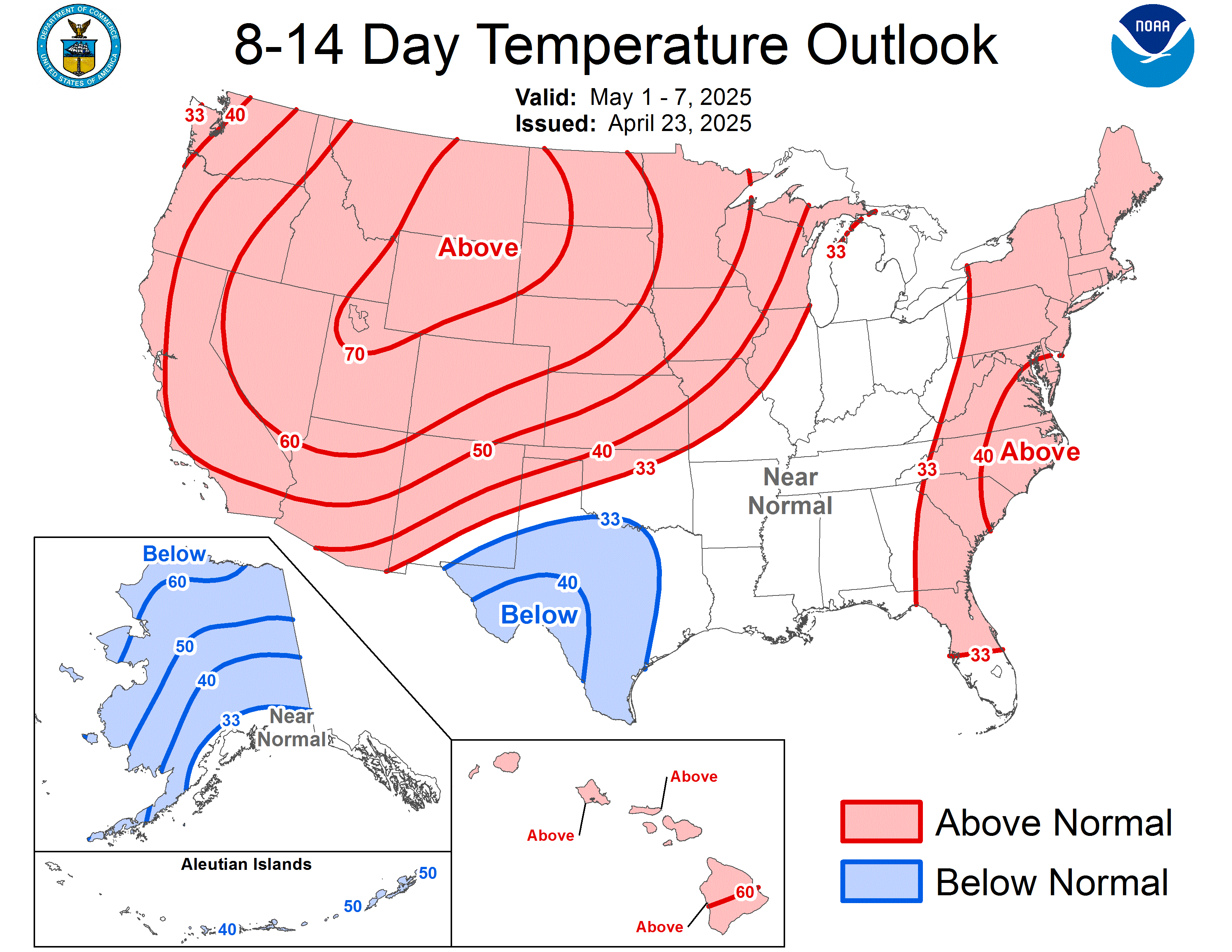
Lengthy, but interesting Discussion from CPC on 6-10 Day & 8-14 Day Outlook...

8-14 Day Temperature Outlook:
Image

8-14 Day Precipitation Outlook:
Image


PROGNOSTIC DISCUSSION FOR 6 TO 10 AND 8 TO 14 DAY OUTLOOKS
NWS CLIMATE PREDICTION CENTER CAMP SPRINGS, MD
300 PM EST MON DEC 08 2008

6-10 DAY OUTLOOK FOR DEC 14 - 18 2008
TODAY'S MODEL SOLUTIONS ARE IN FAIR AGREEMENT ON THE PREDICTION OF THE NORTH
AMERICAN 500-HPA CIRCULATION PATTERN FOR DAYS 6-10. MOST MODELS ARE FORECASTING
A STRONG ANOMALOUS RIDGE CENTERED ALONG THE BERING SEACOAST OF ALASKA OR
SLIGHTLY OFFSHORE, AND A DEEP TROUGH OVER THE WESTERN CONUS. THE ENSEMBLE MEANS
SHOW BROAD CYCLONIC FLOW ACROSS THE EASTERN CONUS, WITH ABOVE NORMAL HEIGHTS
FORECAST OVER THE EASTERN SEABOARD. SOME SOLUTIONS ALSO INDICATE A WESTWARD
EXTENSION OF THESE ABOVE NORMAL HEIGHTS OVER THE GULF COAST STATES. IN GENERAL,
THE OPERATIONAL RUNS HAVE MORE COLD AIR NOSING DOWN FROM EASTERN CANADA ACROSS
NORTHERN NEW ENGLAND. THE CANADIAN ENSEMBLE MEAN PREDICTS A SOMEWHAT WEAKER
TROUGH OVER THE PACIFIC NORTHWEST, BUT IT IS STILL QUITE STRONG. THE BELOW
NORMAL 500-HPA HEIGHTS PREDICTED OVER THE WESTERN CONUS SHOULD SUPPORT BELOW
NORMAL SURFACE TEMPERATURES, WHILE THE ABOVE NORMAL 500-HPA HEIGHTS SHOULD
SUPPORT ABOVE NORMAL SURFACE TEMPERATURES. IN ALASKA, NORTHERLY
MID-TROPOSPHERIC FLOW DOWNSTREAM OF THE STRONG RIDGE AXIS CALLS FOR RELATIVELY
COLD AND DRY CONDITIONS OVER THE SOUTHEAST HALF OF THE STATE.

TODAYS OFFICIAL 500-HPA BLEND CONSISTS OF 10 PERCENT OF TODAY'S OPERATIONAL 0Z
GFS CENTERED ON DAY 8...10 PERCENT OF TODAY'S OPERATIONAL 6Z GFS CENTERED ON
DAY 8...20 PERCENT OF TODAY'S 0Z GFS ENSEMBLE MEAN CENTERED ON DAY 8...20
PERCENT OF TODAY'S 6Z GFS ENSEMBLE MEAN CENTERED ON DAY 8...25 PERCENT OF
TODAY'S GFS SUPERENSEMBLE MEAN CENTERED ON DAY 8...AND 15 PERCENT OF TODAY'S
CANADIAN ENSEMBLE MEAN CENTERED ON DAY 8.

FORECAST CONFIDENCE FOR THE 6-10 DAY PERIOD: AVERAGE, 3 ON A SCALE OF 1 TO 5,
DUE TO FAIR AGREEMENT AMONG THE MODEL SOLUTIONS.


8-14 DAY OUTLOOK FOR DEC 16 - 22 2008
RETROGRESSION OF THE PREDICTED 6-10 DAY LONG WAVE PATTERN IS INDICATED FOR WEEK
2. THE 6Z OPERATIONAL GFS STANDS OUT FROM THE OTHER SOLUTIONS IN THAT IT
DEPICTS A NOTICEABLY DEEPER TROUGH ACROSS THE WESTERN CONUS, WHICH CONTINUES
OVER AND TO THE WEST OF BAJA CALIFORNIA. THIS SOLUTION ALSO HAS THE SOUTHEAST
US RIDGE EXTENDING FURTHER WEST THAN THE OTHER SOLUTIONS, BRINGING ABOVE NORMAL
500-HPA HEIGHTS AS FAR WEST AS THE TEXAS PANHANDLE. ALTHOUGH THE CANADIAN
ENSEMBLE MEAN HAS THE WESTERN TROUGH SOMEWHAT FURTHER NORTH THAN THE 6Z GFS
OPERATIONAL RUN, IT ALSO HINTS AT EXPANDING ANOMALOUS WARMTH FROM THE SOUTHEAST
INTO THE SOUTHERN GREAT PLAINS REGION.

THE OFFICIAL 8-14 DAY HEIGHT PROG CONSISTS OF 15 PERCENT OF TODAY'S OPERATIONAL
0Z GFS CENTERED ON DAY 11...10 PERCENT OF TODAY'S OPERATIONAL 6Z GFS CENTERED
ON DAY 11...20 PERCENT OF TODAY'S 0Z GFS ENSEMBLE MEAN CENTERED ON DAY 11...20
PERCENT OF TODAY'S 6Z GFS ENSEMBLE MEAN CENTERED ON DAY 11...25 PERCENT OF
TODAY'S GFS SUPERENSEMBLE MEAN CENTERED ON DAY 11...AND 10 PERCENT OF TODAY'S
CANADIAN ENSEMBLE MEAN CENTERED ON DAY 11.

FORECAST CONFIDENCE FOR THE 8-14 DAY PERIOD IS: AVERAGE, 3 ON A SCALE OF 1 TO
5, DUE TO FAIRLY GOOD AGREEMENT AMONG THE GFS ENSEMBLE MEAN SOLUTIONS,
TEMPERATURE TOOLS, AND PRECIPITATION TOOLS.


ANALOGS TO THE 5 DAY MEAN OBSERVED PATTERN CENTERED 3 DAYS AGO (D-3)
FOR THE REGION FROM 20N TO 70N LATITUDE AND 175E TO 60W LONGITUDE
INCLUDE THE 5 DAY PERIODS CENTERED ON THE FOLLOWING DATES:
19981217 - 19761204 - 19511210 - 19881208 - 19911203


ANALOGS TO THE 7 DAY MEAN OBSERVED PATTERN CENTERED 4 DAYS AGO (D-4)
FOR THE REGION FROM 20N TO 70N LATITUDE AND 175E TO 60W LONGITUDE
INCLUDE THE 5 DAY PERIODS CENTERED ON THE FOLLOWING DATES:
19761203 - 19981217 - 19751124 - 19571121 - 19881208


$$
0 likes   


Return to “Winter Weather”

Who is online

Users browsing this forum: No registered users and 11 guests