Texas Winter 2013-2014

Winter Weather Discussion

Moderator: S2k Moderators

Forum rules

The posts in this forum are NOT official forecast and should not be used as such. They are just the opinion of the poster and may or may not be backed by sound meteorological data. They are NOT endorsed by any professional institution or STORM2K.

Help Support Storm2K
Message
Author
User avatar
srainhoutx
S2K Supporter
S2K Supporter
Posts: 6919
Age: 67
Joined: Sun Jan 14, 2007 11:34 am
Location: Haywood County, NC
Contact:

Re: Texas Winter 2013-2014

#2421 Postby srainhoutx » Wed Dec 18, 2013 1:41 pm

vbhoutex wrote:Larry Cosgrove pretty much agrees Mr. Rose based on last thing I saw from him on FB.


David, there are some indications that a rather strong storm system will drop S into the Great Basin from Western/Central Canada as a potent Aleutian low push N toward the Bering Sea allowing some much colder air to settle very far S into Arizona/New Mexico and Texas. Add to the mix a strong upper air disturbance crossing Northern Mexico that appears to be cold core in nature with a noisy sub tropical jet and you have a recipe for a variety of wintry weather fairly far South during the weekend before New Years Eve. It's still a ways out, but if the trends continue into next week it will be worth monitoring.
0 likes   
Carla/Alicia/Jerry(In The Eye)/Michelle/Charley/Ivan/Dennis/Katrina/Rita/Wilma/Ike/Harvey

Member: National Weather Association
Wx Infinity Forums
http://wxinfinity.com/index.php

Facebook.com/WeatherInfinity
Twitter @WeatherInfinity

User avatar
dhweather
S2K Supporter
S2K Supporter
Posts: 6199
Joined: Sat Aug 14, 2004 9:29 pm
Location: Heath, TX
Contact:

Re: Texas Winter 2013-2014

#2422 Postby dhweather » Wed Dec 18, 2013 1:43 pm

This is something you'd think more of in March-May, but it's mid December.
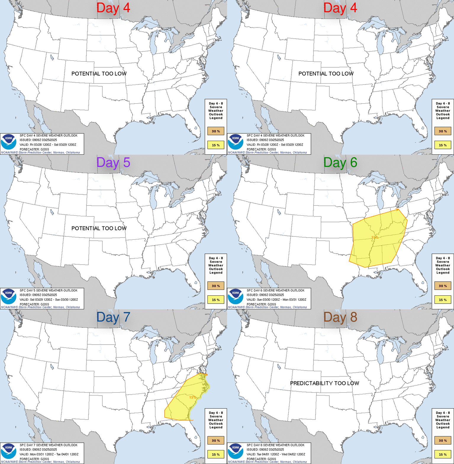

Image


ZCZC SPCSWOD48 ALL
ACUS48 KWNS 181000
SPC AC 181000

DAY 4-8 CONVECTIVE OUTLOOK
NWS STORM PREDICTION CENTER NORMAN OK
0400 AM CST WED DEC 18 2013

VALID 211200Z - 261200Z

...DISCUSSION...
...TX...ARKLATEX...LOWER MS/LOWER OH VALLEY ON SAT/D4...
THE VARIOUS MODELS AND ENSEMBLE MEMBERS ARE IN DECENT AGREEMENT IN
SHOWING THE LOCATION OF GREATEST SEVERE POTENTIAL FROM TX INTO THE
LOWER MS VALLEY ON SAT/D4 AS THE SWRN UPPER LOW/TROUGH EJECTS
RAPIDLY NEWD ALONG WITH A DEVELOPING SURFACE LOW/WAVE ALONG THE
STATIONARY/WARM FRONT. S OF THIS FRONT...AMPLE LOW LEVEL MOISTURE
WILL EXIST WITH MID TO UPPER 60S F DEWPOINTS.

NUMEROUS THUNDERSTORMS SHOULD BE ONGOING ALONG AND N OF A STATIONARY
FRONT EARLY ON SAT/D4...FROM WRN TX NEWD ACROSS THE RED RIVER VALLEY
AND INTO SERN MO...WHERE STRONG WARM AND MOIST ADVECTION WILL EXIST
COURTESY OF A 60 KT SLY LOW LEVEL JET. RAPID COOLING ALOFT...A
VEER/BACK SIGNAL IN THE WIND PROFILE IN THE 850-700 MB LAYER...A
RATHER MERIDIONAL UPPER FLOW REGIME AS WELL AS A SEMI-CAPPED WARM
SECTOR SUGGEST THAT A STRONGLY FORCED QLCS WILL BE LIKELY...CAPABLE
OF DAMAGING WINDS AND A FEW TORNADOES. THE GREATEST THREAT AREA IS
EXPECTED TO BE NEAR THE SURFACE LOW TRACK ALONG THE DEVELOPING WARM
FRONT...OR THE NRN HALF OF THE OUTLOOK AREA.

...SUN/D5 AND BEYOND...
THE SHORTWAVE TROUGH IS FORECAST TO BE LOCATED OVER THE MID MS
VALLEY/LOWER OH VALLEY SUNDAY MORNING WITH LOSS OF AMPLITUDE
COMPARED TO PREVIOUS DAY. AT THE SURFACE...THE COLD FRONT WITH
ONGOING STORMS SHOULD TRAIL APPROXIMATELY FROM IND/OH SWWD ACROSS
TN/AL/MS WITH SOME ONGOING THREAT. GIVEN TIMING ISSUES AS WELL AS
THE LOSS OF THE SHORTWAVE TROUGH TO THE N...WILL DEFER ANY SEVERE
AREAS TO LATER OUTLOOKS. AT THIS TIME...IT APPEARS THE GREATEST
POTENTIAL FOR DAMAGING WINDS AND/OR A FEW TORNADOES WOULD BE ACROSS
ERN MS/AL/GA AND TN IN PROXIMITY TO THE MOST ROBUST MOISTURE AND
MARGINAL INSTABILITY...WITH LINEAR STORM MODE MOST LIKELY.

..JEWELL.. 12/18/2013
0 likes   
The above post and any post by dhweather is NOT an official forecast and should not be used as such. It is just the opinion of the poster and may or may not be backed by sound meteorological data. It is NOT endorsed by any professional institution including storm2k.org. For official information, please refer to NWS products.

User avatar
dhweather
S2K Supporter
S2K Supporter
Posts: 6199
Joined: Sat Aug 14, 2004 9:29 pm
Location: Heath, TX
Contact:

#2423 Postby dhweather » Wed Dec 18, 2013 2:28 pm

I don't know that this is the right place to discuss this, but I'll give it a try.

I started following Joe B on twitter a couple of weeks ago, and the guy is about to force me to un-follow him. Hyping weather, political rants, socioeconomic rants, climate change rants, and so on.

It occurred to me that likely led to making me irritable on here, for which I apologize to all. I should focus my Joe B angst towards Joe B and not my peeps here.


Now, how are we gonna get some significant snow here? My 3 year old needs to see it this year!
0 likes   
The above post and any post by dhweather is NOT an official forecast and should not be used as such. It is just the opinion of the poster and may or may not be backed by sound meteorological data. It is NOT endorsed by any professional institution including storm2k.org. For official information, please refer to NWS products.

User avatar
wxman57
Moderator-Pro Met
Moderator-Pro Met
Posts: 22991
Age: 67
Joined: Sat Jun 21, 2003 8:06 pm
Location: Houston, TX (southwest)

Re:

#2424 Postby wxman57 » Wed Dec 18, 2013 2:31 pm

dhweather wrote:I don't know that this is the right place to discuss this, but I'll give it a try.

I started following Joe B on twitter a couple of weeks ago, and the guy is about to force me to un-follow him. Hyping weather, political rants, socioeconomic rants, climate change rants, and so on.
It occurred to me that likely led to making me irritable on here, for which I apologize to all. I should focus my Joe B angst towards Joe B and not my peeps here.
Now, how are we gonna get some significant snow here? My 3 year old needs to see it this year!


JB can have that effect on people. ;-)

As for snow up in Heath this winter, I'd say you have a better-than-not chance of seeing a significant snow event in January or February, possibly even near Dec. 27th-28th according to the European ensembles. The pattern we're in is certainly one that could bring down some very cold air, and we're getting a good bit of southern stream energy moving across the cold air.
0 likes   

User avatar
gboudx
S2K Supporter
S2K Supporter
Posts: 4080
Joined: Thu Sep 04, 2003 1:39 pm
Location: Rockwall, Tx but from Harvey, La

#2425 Postby gboudx » Wed Dec 18, 2013 2:34 pm

I don't like seeing that Severe weather graphic. We're driving down to NOLA on Saturday and will be heading over to Shrevesburg and down 49 to Lafayette. Though it's better than ice in the forecast.
0 likes   

User avatar
Tireman4
S2K Supporter
S2K Supporter
Posts: 5853
Age: 59
Joined: Fri Jun 30, 2006 1:08 pm
Location: Humble, Texas
Contact:

Re: Re:

#2426 Postby Tireman4 » Wed Dec 18, 2013 2:37 pm

wxman57 wrote:
dhweather wrote:I don't know that this is the right place to discuss this, but I'll give it a try.

I started following Joe B on twitter a couple of weeks ago, and the guy is about to force me to un-follow him. Hyping weather, political rants, socioeconomic rants, climate change rants, and so on.
It occurred to me that likely led to making me irritable on here, for which I apologize to all. I should focus my Joe B angst towards Joe B and not my peeps here.
Now, how are we gonna get some significant snow here? My 3 year old needs to see it this year!


JB can have that effect on people. ;-)

As for snow up in Heath this winter, I'd say you have a better-than-not chance of seeing a significant snow event in January or February. The pattern we're in is certainly one that could bring down some very cold air, and we're getting a good bit of southern stream energy moving across the cold air.


And what do you think about Houston getting something this year (Winter)?
0 likes   

User avatar
ThunderSleetDreams
S2K Supporter
S2K Supporter
Posts: 1477
Age: 43
Joined: Tue Dec 20, 2011 4:42 pm
Location: S of Weimar, TX

Re:

#2427 Postby ThunderSleetDreams » Wed Dec 18, 2013 2:53 pm

dhweather wrote:I don't know that this is the right place to discuss this, but I'll give it a try.

I started following Joe B on twitter a couple of weeks ago, and the guy is about to force me to un-follow him. Hyping weather, political rants, socioeconomic rants, climate change rants, and so on.

It occurred to me that likely led to making me irritable on here, for which I apologize to all. I should focus my Joe B angst towards Joe B and not my peeps here.


Now, how are we gonna get some significant snow here? My 3 year old needs to see it this year!


I follow him for this very reason. I love seeing him take some AGW nuts to task and the idiot AGW professors who are drumming up scare tactics for $$$.

Joe is annoying with his end of the world weather forecasts, but I find his political and AGW views and rants breathtakingly awesome!
0 likes   
#NeverSummer

I hibernate when it gets above 75 degrees!

User avatar
TheProfessor
Professional-Met
Professional-Met
Posts: 3506
Age: 28
Joined: Tue Dec 03, 2013 10:56 am
Location: Wichita, Kansas

#2428 Postby TheProfessor » Wed Dec 18, 2013 2:54 pm

If the front stalls a little bit closer to the I-20 I-30 area, could this become a big rain event in North Texas? Maybe even some flooding?
0 likes   
An alumnus of The Ohio State University.

Your local National Weather Service office is your best source for weather information.

User avatar
Portastorm
Storm2k Moderator
Storm2k Moderator
Posts: 9914
Age: 63
Joined: Fri Jul 11, 2003 9:16 am
Location: Round Rock, TX
Contact:

Re:

#2429 Postby Portastorm » Wed Dec 18, 2013 2:58 pm

TheProfessor wrote:If the front stalls a little bit closer to the I-20 I-30 area, could this become a big rain event in North Texas? Maybe even some flooding?


Suggest you check out your local NWSFO page. They have some good info on there related to your question.

http://www.srh.noaa.gov/fwd/
0 likes   
Any forecasts under my name are to be taken with a grain of salt. Get your best forecasts from the National Weather Service and National Hurricane Center.

User avatar
wxman57
Moderator-Pro Met
Moderator-Pro Met
Posts: 22991
Age: 67
Joined: Sat Jun 21, 2003 8:06 pm
Location: Houston, TX (southwest)

Re: Re:

#2430 Postby wxman57 » Wed Dec 18, 2013 2:58 pm

Tireman4 wrote:And what do you think about Houston getting something this year (Winter)?


A lot lower than Dallas' chances. If "something" is defined as measurable snow, then probably around 5%. For sleet, maybe 40-50%. For a snow flurry, maybe 10-20%. Next 90F degree day - probably the 3rd week of March. I can dream...
0 likes   

User avatar
dhweather
S2K Supporter
S2K Supporter
Posts: 6199
Joined: Sat Aug 14, 2004 9:29 pm
Location: Heath, TX
Contact:

#2431 Postby dhweather » Wed Dec 18, 2013 3:39 pm

I doubt that one person in North Texas would complain if it rained five inches this weekend. Hopefully just not all in one hour. :lol:
0 likes   
The above post and any post by dhweather is NOT an official forecast and should not be used as such. It is just the opinion of the poster and may or may not be backed by sound meteorological data. It is NOT endorsed by any professional institution including storm2k.org. For official information, please refer to NWS products.

User avatar
dhweather
S2K Supporter
S2K Supporter
Posts: 6199
Joined: Sat Aug 14, 2004 9:29 pm
Location: Heath, TX
Contact:

Re: Re:

#2432 Postby dhweather » Wed Dec 18, 2013 3:41 pm

ThunderSleetDreams wrote:
dhweather wrote:I don't know that this is the right place to discuss this, but I'll give it a try.

I started following Joe B on twitter a couple of weeks ago, and the guy is about to force me to un-follow him. Hyping weather, political rants, socioeconomic rants, climate change rants, and so on.

It occurred to me that likely led to making me irritable on here, for which I apologize to all. I should focus my Joe B angst towards Joe B and not my peeps here.


Now, how are we gonna get some significant snow here? My 3 year old needs to see it this year!


I follow him for this very reason. I love seeing him take some AGW nuts to task and the idiot AGW professors who are drumming up scare tactics for $$$.

Joe is annoying with his end of the world weather forecasts, but I find his political and AGW views and rants breathtakingly awesome!


I will give ol' Joe credit for one thing - he's dead on with "enjoy your weather, it's the only weather you've got".
0 likes   
The above post and any post by dhweather is NOT an official forecast and should not be used as such. It is just the opinion of the poster and may or may not be backed by sound meteorological data. It is NOT endorsed by any professional institution including storm2k.org. For official information, please refer to NWS products.

User avatar
Red Raider fan
Tropical Depression
Tropical Depression
Posts: 72
Joined: Fri Dec 13, 2013 11:31 am
Location: Schertz Tx.

#2433 Postby Red Raider fan » Wed Dec 18, 2013 4:29 pm

i have read on here and on accuweather that it looks like after christmas before new years time frame significant cold coming out of canada and a low over baja tracking across texas in the same time frame may get intresting here for some wintry precip. But i will say our chances for any snow is usually around January-February. I remember 1985 13 inches of snow in San Antonio. :ggreen:
0 likes   

weatherdude1108
Category 5
Category 5
Posts: 4228
Joined: Tue Dec 13, 2011 1:04 pm
Location: Northwest Austin/Cedar Park, TX

Re:

#2434 Postby weatherdude1108 » Wed Dec 18, 2013 4:59 pm

Red Raider fan wrote:i have read on here and on accuweather that it looks like after christmas before new years time frame significant cold coming out of canada and a low over baja tracking across texas in the same time frame may get intresting here for some wintry precip. But i will say our chances for any snow is usually around January-February. I remember 1985 13 inches of snow in San Antonio. :ggreen:


Yes Red Raider fan! (btw I am also a Red Raider fan :wink: ). I was there for that San Antonio snowstorm as a youngster. We took a family picture in front of our mailbox, and put a red bow on the mailbox. We used that photo as the Christmas card later that year in December 1985. :D That snowstorm made me fall in love with the weather and how it works. :cheesy: Every year after that, I dreamed it would snow, as did everyone else. It shut down the whole city of San Antonio for about three days I think.

I remember it started Friday night. The temperatures were getting progressively colder. My brother and I went walking down the neighborhood, seeing snowflakes in the street light beams cascading towards the street/trees. The next morning, there was a 14-inch blanket covering everything, and made the Live Oak tree in front of our house bend over all the way to the ground. It never snapped amazingly! We took out an old sled my parents had in the attic, used trash can lids, rafts, and anything you could think of to slide down the hills. I will never forget that weekend! :D :froze:
0 likes   

User avatar
TheProfessor
Professional-Met
Professional-Met
Posts: 3506
Age: 28
Joined: Tue Dec 03, 2013 10:56 am
Location: Wichita, Kansas

#2435 Postby TheProfessor » Wed Dec 18, 2013 5:10 pm

Is there any chance that the low goes 100-150 miles to the south of what they're predicting.
0 likes   
An alumnus of The Ohio State University.

Your local National Weather Service office is your best source for weather information.

User avatar
JDawg512
Category 5
Category 5
Posts: 1078
Age: 45
Joined: Mon Aug 26, 2013 8:56 pm
Location: Austin
Contact:

Re: Texas Winter 2013-2014

#2436 Postby JDawg512 » Wed Dec 18, 2013 5:12 pm

Red Raider fan wrote:i have read on here and on accuweather that it looks like after christmas before new years time frame significant cold coming out of canada and a low over baja tracking across texas in the same time frame may get intresting here for some wintry precip. But i will say our chances for any snow is usually around January-February. I remember 1985 13 inches of snow in San Antonio. :ggreen:


I remember that snow event as well here in Austin. Was 5 years old and I remember how weird I thought it was having my parents put my boots in plastic bags and wrapping tape around them. I felt like a poof ball with all those layers of clothes and a big coat. Once I walked into the back yard I was just mesmerized at all the white fluffy stuff everywhere. Me, my sister, and my dad built a huge snow man that was as tall as my dad. To this day, I have yet to build a snow man bigger than the size of two snowballs clumped together lol. (Oh.... I did make one large snowball during the 2004 Valentines Day snow event. It was 2 a.m. but I was out there rolling a snowball around the yard until it got too heavy to roll.)lol

Anywho, I am shifting my concern to the possible severe weather event or at least the threat of heavy rain. Not sure if a lot of forumers outside of Austin realize but there's still whole sections of neighborhoods on the city's southeast side in ruin from the Halloween morning floods. Many people still can't live in their homes due to the damage. We have temporary neighbors that moved into the house next to mine and they are having to rebuild their house in Bluff Springs. Their family was lucky to make it out alive. The lady was telling me how people were climbing into their attics and using hatchets to break through to the roofs and how they had to wait on the roof till rescuers came.

The situation continues to be serious for hundreds of families and there are local donation drives still going on to help in the recovery efforts. If we see training of heavy rains occur, I really hope it happens 10 to 20 miles west of Austin so all that water can fill up Lake Travis. It would be really bad for Austin to get slammed with several inches of rain like we did twice in October, especially when we are far from recovered from the last floods.
0 likes   
Resident Rain Miser

I am a weather hobbyist living 3.5 miles south of Downtown Austin and in no way or fashion should anything I say concerning forecasts be taken seriously. Please check your local NWS for accurate weather forecasting and conditions.

User avatar
hriverajr
Professional-Met
Professional-Met
Posts: 786
Joined: Tue Jul 19, 2005 12:16 am

Re: Texas Winter 2013-2014

#2437 Postby hriverajr » Wed Dec 18, 2013 6:06 pm

Found the Link below on another site. Really nice link to visualize the winds at different pressure levels. You can go backwards in three hour increments. Click on earth to change levels and times

Here is the link http://earth.nullschool.net/#current/wind/isobaric/1000hPa/orthographic=-114.57,63.00,676
0 likes   

User avatar
Red Raider fan
Tropical Depression
Tropical Depression
Posts: 72
Joined: Fri Dec 13, 2013 11:31 am
Location: Schertz Tx.

#2438 Postby Red Raider fan » Wed Dec 18, 2013 6:33 pm

You are right we need to be discussing the possibility of severe weather in this area this weekend, although i haven't seen anything on accuweather on it, but have read the thread from NWS from Norman OK. looks like we are in for a humdinger of an severe event. Need to stay tuned for further news as this event folds. Still haven't seen anything from NWS out of Austin - San Antonio if this will impact us here in south texas.
0 likes   

User avatar
dhweather
S2K Supporter
S2K Supporter
Posts: 6199
Joined: Sat Aug 14, 2004 9:29 pm
Location: Heath, TX
Contact:

Re:

#2439 Postby dhweather » Wed Dec 18, 2013 7:33 pm

TheProfessor wrote:Is there any chance that the low goes 100-150 miles to the south of what they're predicting.


There's always a chance. That said, the models have been pretty consistent , so I wouldn't expect more than 50 miles difference.
0 likes   
The above post and any post by dhweather is NOT an official forecast and should not be used as such. It is just the opinion of the poster and may or may not be backed by sound meteorological data. It is NOT endorsed by any professional institution including storm2k.org. For official information, please refer to NWS products.

User avatar
Ntxw
Storm2k Moderator
Storm2k Moderator
Posts: 22792
Joined: Wed Oct 21, 2009 6:34 pm
Location: DFW, Texas

#2440 Postby Ntxw » Wed Dec 18, 2013 8:50 pm

Quick update on the EPO tonight, models forecasting of it to go positive has not panned out. It rose to about -98 and is falling again. Still lurking up there, at the pace we are falling it may reach -2/-3SD's again. The WPO is also currently at it's lowest point so far this season.
0 likes   
The above post and any post by Ntxw is NOT an official forecast and should not be used as such. It is just the opinion of the poster and may or may not be backed by sound meteorological data. It is NOT endorsed by any professional institution including Storm2k. For official information, please refer to NWS products.

  Help support Storm2K!
Help Support Storm2K


Return to “Winter Weather”

Who is online

Users browsing this forum: No registered users and 28 guests