Don...I think it's awsome that you came back and admitted you were a bit off. I know the feeling. You seem to have great knowledge about blocks, teleconnections, and all of that. Do you have any great insight into what the key would be for the west to finally get a decent winter? We have been ripped off out here for YEARS now. Believe it not the average snowfall for the Seattle area has been 3 times lower in the past 20 years that it was for the 1945 - 1975 period. I have some ideas on what is going on here, but it would be interesting to see if you have any thoughts.
We are dying out here! Hopefully, you will have some encouraging words.
2/28-3/1/2005 Storm: Initial Estimates
Moderator: S2k Moderators
Forum rules
 The posts in this forum are NOT official forecast and should not be used as such. They are just the opinion of the poster and may or may not be backed by sound meteorological data. They are NOT endorsed by any professional institution or STORM2K.

The posts in this forum are NOT official forecast and should not be used as such. They are just the opinion of the poster and may or may not be backed by sound meteorological data. They are NOT endorsed by any professional institution or STORM2K.
-
snow_wizzard
- Category 4

- Posts: 994
- Joined: Mon Jan 17, 2005 12:15 am
- Location: Covington, WA
-
donsutherland1
- S2K Analyst

- Posts: 2718
- Joined: Mon Sep 15, 2003 8:49 pm
- Location: New York
Snow_wizzard,
The general idea prior to the estimates was pretty reasonable (see Feb. 27-March 12 pattern discussion). Unfortunately, when it came to detailed amounts several developments outweighed the correct idea of an offshore/coastal track:
1) PNA did not rise as quickly as progged. The GFS ensembles indicated that it would be close to +2.000 at the time of the storm. It was below +1.000 by the time the storm started. The trough was not as sharp and the extreme block helped send the storm much farther offshore than might otherwise have been the case.
2) The NAM had problems even as it usually does a reasonable job with respect to highlighting precipitation. The GFS was drier and I overestimated QPF especially as the storm early on was producing more precipitation across Florida than modeled.
3) The storm did not intensify as much as earlier modeled. This also had adverse ramifications.
Going to the West, what the West really needs is a winter where the PDO is strongly negative. The following is a composite of temperature anomalies during the 5 most negative PDO winters since 1948-49:
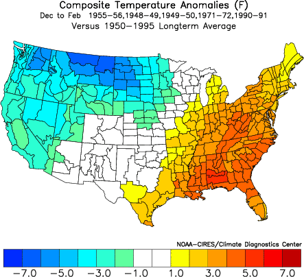
From 1945-46 through 1974-75, the winter PDO was negative in 24/30 (80%) winters. However, from 1975-76 through 2003-04, the PDO was positive in 20/29 (69%) winters.
The general idea prior to the estimates was pretty reasonable (see Feb. 27-March 12 pattern discussion). Unfortunately, when it came to detailed amounts several developments outweighed the correct idea of an offshore/coastal track:
1) PNA did not rise as quickly as progged. The GFS ensembles indicated that it would be close to +2.000 at the time of the storm. It was below +1.000 by the time the storm started. The trough was not as sharp and the extreme block helped send the storm much farther offshore than might otherwise have been the case.
2) The NAM had problems even as it usually does a reasonable job with respect to highlighting precipitation. The GFS was drier and I overestimated QPF especially as the storm early on was producing more precipitation across Florida than modeled.
3) The storm did not intensify as much as earlier modeled. This also had adverse ramifications.
Going to the West, what the West really needs is a winter where the PDO is strongly negative. The following is a composite of temperature anomalies during the 5 most negative PDO winters since 1948-49:
From 1945-46 through 1974-75, the winter PDO was negative in 24/30 (80%) winters. However, from 1975-76 through 2003-04, the PDO was positive in 20/29 (69%) winters.
0 likes
Who is online
Users browsing this forum: No registered users and 174 guests