


Possible Major East Coast Storm early next week
Moderator: S2k Moderators
Forum rules
 The posts in this forum are NOT official forecast and should not be used as such. They are just the opinion of the poster and may or may not be backed by sound meteorological data. They are NOT endorsed by any professional institution or STORM2K.

The posts in this forum are NOT official forecast and should not be used as such. They are just the opinion of the poster and may or may not be backed by sound meteorological data. They are NOT endorsed by any professional institution or STORM2K.
-
Ed Mahmoud
Re: Possible Major East Coast Storm early next week
Perhaps the Euro has shifted far enough East for a change back to snow in some of the Big Cities...


One thing, besides being further East, the Euro seems a tad less intense than the previous 0Z run.
One thing, besides being further East, the Euro seems a tad less intense than the previous 0Z run.
0 likes
-
Ed Mahmoud
Re: Possible Major East Coast Storm early next week
Canadian seems to jibe with something Joe Bastardi mentioned, NYC may go back to snow, but BOS may see mostly rain, which is a rare event, snow in NYC and rain in BOS.
Of course, one of my favorite historic storms of all time, the March 1888 NYC blizzard was rain changing to sleet than snow in NYC, but remained mostly rain in Boston.
GFS a lot like the Canadian, just a touch further West, enough to keep NYC mostly rain.
Looks like SPC will wait for another day of data and model runs before introducing a risk area for the Eastern Gulf Coast area...
DAY 4-8 CONVECTIVE OUTLOOK
NWS STORM PREDICTION CENTER NORMAN OK
0329 AM CST FRI JAN 30 2009
VALID 021200Z - 071200Z
...DISCUSSION...
EVOLUTION OF LONG WAVE TROUGH OVER THE ERN U.S. WILL LARGELY DICTATE
THE INTENSITY/PROGRESSION OF SFC LOW OVER THE NERN GULF OF MEXICO
DURING THE DAY4-5 TIME PERIOD. GFS IS MORE AGGRESSIVE MERGING
NRN/SRN STREAMS AND DEEPENING UPPER TROUGH OVER THE MS
VALLEY...WHILE ECMWF MAINTAINS IDENTITY OF SRN STREAM SHORTWAVE OVER
THE NRN GULF OF MEXICO. GFS INTENSIFIES SFC LOW MORE QUICKLY OVER
THE NERN GULF WHILE THE ECMWF IS WEAKER AND SLOWER WITH THIS
DEVELOPMENT. GIVEN THAT 00Z MODELS DO NOT DESTABILIZE THE FL
PENINSULA TO ANY GREAT EXTENT...INTENSITY/TIMING OF DEVELOPING LOW
PRESSURE SYSTEM IS TOO UNCERTAIN TO INTRODUCE A SEVERE OUTLOOK AT
THIS TIME.
..DARROW.. 01/30/2009
0 likes
-
Weatherfreak14

- Category 5

- Posts: 1381
- Joined: Sat Sep 24, 2005 3:40 pm
- Location: Beaufort, SC
- Contact:
Re: Possible Major East Coast Storm early next week
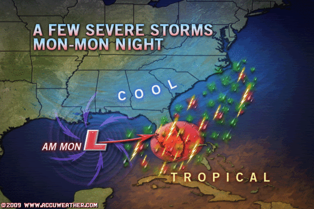
Looks like we will be in for another day of snow here in the Low Country. Also looking at the 12Z GFS looks like its seeing the low pressure a lot farther east than before.
NWS IN CHS Area Forecast Disscussion..
MON THROUGH TUE NIGHT...AN AREA OF LOW PRES IS EXPECTED TO BE MOVING
NE OUT OF THE GULF COAST REGION THROUGH THE PERIOD. THE EXACT
STRENGTH/TRACK OF THIS SYSTEM IS STILL IN QUESTION YIELDING A
PROBLEMATIC FORECAST. GENERALLY MAINTAINED PERSISTENCE FROM THE
PREVIOUS FORECAST WHICH TAKES THE LOW RIGHT THROUGH SE GA/SRN SC MON
AND WILL HAVE THE HIGHEST POPS /60S/ THIS PERIOD...TAPERING OFF FROM
SW TO NE MON NIGHT AS THE LOW PULLS AWAY FROM THE AREA. MUCH COLDER
AIR IS EXPECTED TO MOVE IN BEHIND THE LOW WHICH COULD YIELD SOME
WINTRY PRECIP ACROSS THE AREA...ESPECIALLY ACROSS SRN SC...LATE MON
NIGHT INTO TUE AS THE STRONG UPPER TROUGH SWINGS THROUGH.
HOWEVER...WILL LEAVE ANY MENTION OF SNOW OUT OF THE FORECAST FOR NOW
UNTIL CONFIDENCE INCREASES. TEMPS WILL LIKELY FALL DURING THE DAY
TUE AND BOTTOM OUT IN THE UPPER TEENS INLAND WED MORNING. WE MAY
EVEN BE DEALING WITH A WIND CHILL ADVISORY WED MORNING FOR WIND
CHILLS AROUND 5 DEGREES ABOVE ZERO.
0 likes
-
vbhoutex

- Storm2k Executive

- Posts: 29150
- Age: 74
- Joined: Wed Oct 09, 2002 11:31 pm
- Location: Cypress, TX
- Contact:
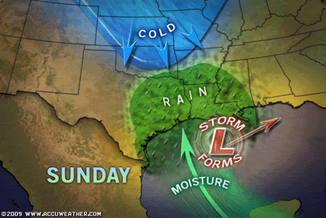
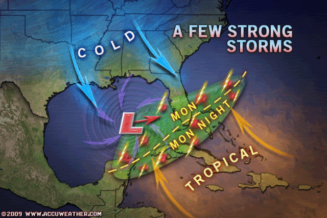
Re:
HURAKAN wrote:
Accuweather.
I hope that is right as far as the rain is concerned!! We need it!! Our local ocm's arenn't haolding out a lot of hope though. Jeff Lindner is expecting it to be hit and miss at best for rain in our area(SE TX).
0 likes
-
Ed Mahmoud
Re: Possible Major East Coast Storm early next week
JB likes the general look of the 6Z GFS on this, he thinks the 12Z GFS is too weak early, and too far East, and overdoes East Coast snow.
0 likes
-
Weatherfreak14
- Category 5
- Posts: 1381
- Joined: Sat Sep 24, 2005 3:40 pm
- Location: Beaufort, SC
- Contact:
Re: Possible Major East Coast Storm early next week
Ed Mahmoud wrote:JB likes the general look of the 6Z GFS on this, he thinks the 12Z GFS is too weak early, and too far East, and overdoes East Coast snow.
I can agree on half of that. I actually think that this might bomb out alot earlier and quicker than the 12Z gfs and getting a whole lot of moisture getting wrapped around into the SE into Monday Night. The exact track of the Low is the tricky part, I think that it will follow right along the coast of the SE maybe even about 20-50 mi out from the coast.
IMO I still see a major event possible.
0 likes
-
srainhoutx

- S2K Supporter

- Posts: 6919
- Age: 68
- Joined: Sun Jan 14, 2007 11:34 am
- Location: Haywood County, NC
- Contact:
Re: Possible Major East Coast Storm early next week
FYI: NOAA Recon Missions at work...
WEATHER RECONNAISSANCE FLIGHTS
CARCAH, NATIONAL HURRICANE CENTER, MIAMI, FL.
1145 AM EST THU 29 JAN 2009
SUBJECT: WINTER STORM PLAN OF THE DAY (WSPOD)
VALID 30/1100Z TO 31/1100Z JAN 2009
WSPOD NUMBER.....08-060
I. ATLANTIC REQUIREMENTS
1. NEGATIVE RECONNAISSANCE REQUIREMENTS.
2. SUCCEEDING DAY OUTLOOK.....NEGATIVE.
II. PACIFIC REQUIREMENTS
1. FLIGHT ONE - TEAL 75
A. P28/ 35.0N 150.0W/ 30/1200Z
B. AFXXX 07WSC TRACK28
C. 30/0600Z
D. 20 DROPS ON TRACK AS PUBLISHED
E. AS HIGH AS POSSIBLE/ 30/1800Z
2. OUTLOOK FOR SUCCEEDING DAY:
A. P15/ 41N 162W/ 31/1200Z
WEATHER RECONNAISSANCE FLIGHTS
CARCAH, NATIONAL HURRICANE CENTER, MIAMI, FL.
0930 AM EST FRI 30 JAN 2009
SUBJECT: WINTER STORM PLAN OF THE DAY (WSPOD)
VALID 31/1100Z JAN TO 01/1100Z FEB 2009
WSPOD NUMBER.....08-061
I. ATLANTIC REQUIREMENTS
1. NEGATIVE RECONNAISSANCE REQUIREMENTS.
2. SUCCEEDING DAY OUTLOOK.....NEGATIVE.
II. PACIFIC REQUIREMENTS
1. FLIGHT ONE -- TEAL 76
A. P15/ 41.0N 162.0W/ 31/1200Z
B. AF300 08WSC TRACK15
C. 31/0500Z
D. 16 DROPS ON TRACK AS PUBLISHED
E. AS HIGH AS POSSIBLE/ 31/1800Z
2. OUTLOOK FOR SUCCEEDING DAY.....NEGATIVE.
WEATHER RECONNAISSANCE FLIGHTS
CARCAH, NATIONAL HURRICANE CENTER, MIAMI, FL.
1145 AM EST THU 29 JAN 2009
SUBJECT: WINTER STORM PLAN OF THE DAY (WSPOD)
VALID 30/1100Z TO 31/1100Z JAN 2009
WSPOD NUMBER.....08-060
I. ATLANTIC REQUIREMENTS
1. NEGATIVE RECONNAISSANCE REQUIREMENTS.
2. SUCCEEDING DAY OUTLOOK.....NEGATIVE.
II. PACIFIC REQUIREMENTS
1. FLIGHT ONE - TEAL 75
A. P28/ 35.0N 150.0W/ 30/1200Z
B. AFXXX 07WSC TRACK28
C. 30/0600Z
D. 20 DROPS ON TRACK AS PUBLISHED
E. AS HIGH AS POSSIBLE/ 30/1800Z
2. OUTLOOK FOR SUCCEEDING DAY:
A. P15/ 41N 162W/ 31/1200Z
WEATHER RECONNAISSANCE FLIGHTS
CARCAH, NATIONAL HURRICANE CENTER, MIAMI, FL.
0930 AM EST FRI 30 JAN 2009
SUBJECT: WINTER STORM PLAN OF THE DAY (WSPOD)
VALID 31/1100Z JAN TO 01/1100Z FEB 2009
WSPOD NUMBER.....08-061
I. ATLANTIC REQUIREMENTS
1. NEGATIVE RECONNAISSANCE REQUIREMENTS.
2. SUCCEEDING DAY OUTLOOK.....NEGATIVE.
II. PACIFIC REQUIREMENTS
1. FLIGHT ONE -- TEAL 76
A. P15/ 41.0N 162.0W/ 31/1200Z
B. AF300 08WSC TRACK15
C. 31/0500Z
D. 16 DROPS ON TRACK AS PUBLISHED
E. AS HIGH AS POSSIBLE/ 31/1800Z
2. OUTLOOK FOR SUCCEEDING DAY.....NEGATIVE.
0 likes
-
Ed Mahmoud
Re: Possible Major East Coast Storm early next week
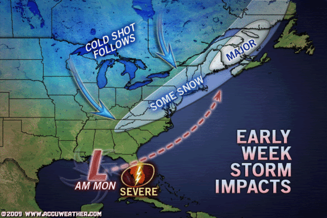
GFS well offshore, such that NYC and BOS are mainly snow, ballpark 6 to 10 inches, with strongest winds New York and New England rather than back into Pennsylvania and Ohio.
Even the I95 corridor looks less impressive, as compared to the Euro's 80 knot 850 mb jet of a couple of days ago, but 30 knot winds and snow is still nothing to sneeze at.
Assuming the GFS is correct.

Even the I95 corridor looks less impressive, as compared to the Euro's 80 knot 850 mb jet of a couple of days ago, but 30 knot winds and snow is still nothing to sneeze at.
Assuming the GFS is correct.
0 likes
-
Ed Mahmoud
Re: Possible Major East Coast Storm early next week
The trend of the models is towards fairly unimpressive and not terribly exciting...
0 likes

-
thunderchief

- Category 1

- Posts: 306
- Joined: Tue Aug 23, 2005 11:03 pm
-
abryant.ma

- Tropical Low

- Posts: 46
- Joined: Wed Jul 19, 2006 11:01 am
- Location: Mashpee, Cape Cod, Massachusetts
Re: Possible Major East Coast Storm early next week
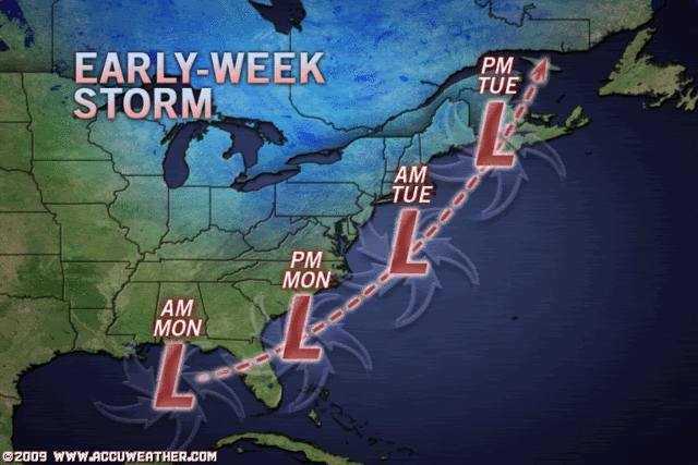
Ok guys, an interesting development.
Last night most models showed the main storm way east and offshore.
An interesting thing though is that they were showing a secondary LLC (low-level circulation) developing just west of the primary storm, closer to the shore. This shows that the storm is going have a lot of energy to push around (I think).


I'm no pro meteorologist BUT this storm needs to be watched VERY closely.
Also, its looking like this storm WILL be a snow producing one, with the typical rain/mix at the coast.
More to come later..
Last night most models showed the main storm way east and offshore.
An interesting thing though is that they were showing a secondary LLC (low-level circulation) developing just west of the primary storm, closer to the shore. This shows that the storm is going have a lot of energy to push around (I think).
I'm no pro meteorologist BUT this storm needs to be watched VERY closely.
Also, its looking like this storm WILL be a snow producing one, with the typical rain/mix at the coast.
More to come later..
0 likes
-
Tampa Bay Hurricane

- Category 5
- Posts: 5597
- Age: 38
- Joined: Fri Jul 22, 2005 7:54 pm
- Location: St. Petersburg, FL
-
abryant.ma
- Tropical Low
- Posts: 46
- Joined: Wed Jul 19, 2006 11:01 am
- Location: Mashpee, Cape Cod, Massachusetts
Re: Possible Major East Coast Storm early next week
Storm can already be seen getting itself together along the coast of GOM.
http://www.goes.noaa.gov/GSSLOOPS/ecwv.html
Hmm I'm thinking this storm will make a closer track to the coast, rather than farther out to shore, as it's developing along the coats instead of in the middle of GOM, where it was supposed too.
http://www.goes.noaa.gov/GSSLOOPS/ecwv.html
Hmm I'm thinking this storm will make a closer track to the coast, rather than farther out to shore, as it's developing along the coats instead of in the middle of GOM, where it was supposed too.
0 likes
-
Ed Mahmoud
Re: Possible Major East Coast Storm early next week
Darned, I was so excited about the Euro's 40 m/s 850 mb jet near NYC from a few days ago.
JB seems to be thinking (judging from videos) 3-6" I-95 from PHL area to NYC, maybe double that in BOS, and the Gulf system is "window dressing", the big player is in the Northern stream.
12Z WRF seems close to JB's idea, and I hope it is right, about four/tenths of much needed rain tonight for HOU ahead of the polar front.
0 likes
-
vbhoutex
- Storm2k Executive
- Posts: 29150
- Age: 74
- Joined: Wed Oct 09, 2002 11:31 pm
- Location: Cypress, TX
- Contact:
Re: Possible Major East Coast Storm early next week
I hope the WRF is rignt!!! WE NEED THE RAIN!!!
I guess I wasn't the only one that saw the "double" low in the models last night. I agree that everyone from FL up the East coast needs to keep a close tab on what is developing. It is definitely ever changing or so it seems to me.
I guess I wasn't the only one that saw the "double" low in the models last night. I agree that everyone from FL up the East coast needs to keep a close tab on what is developing. It is definitely ever changing or so it seems to me.
0 likes
Who is online
Users browsing this forum: No registered users and 87 guests