Texas Winter 2016-2017
Moderator: S2k Moderators
Forum rules
 The posts in this forum are NOT official forecast and should not be used as such. They are just the opinion of the poster and may or may not be backed by sound meteorological data. They are NOT endorsed by any professional institution or STORM2K.

The posts in this forum are NOT official forecast and should not be used as such. They are just the opinion of the poster and may or may not be backed by sound meteorological data. They are NOT endorsed by any professional institution or STORM2K.
-
Yukon Cornelius
- S2K Supporter

- Posts: 1842
- Age: 42
- Joined: Thu Dec 20, 2012 9:23 pm
- Location: Dean, TX/Westcliffe, CO
Re: Texas Winter 2016-2017
Started December off with our 3rd frost and 3rd freeze. Hopefully this is a sign of whats to come this month.
0 likes
#neversummer
-
Portastorm

- Storm2k Moderator

- Posts: 9955
- Age: 63
- Joined: Fri Jul 11, 2003 9:16 am
- Location: Round Rock, TX
- Contact:
Re: Texas Winter 2016-2017
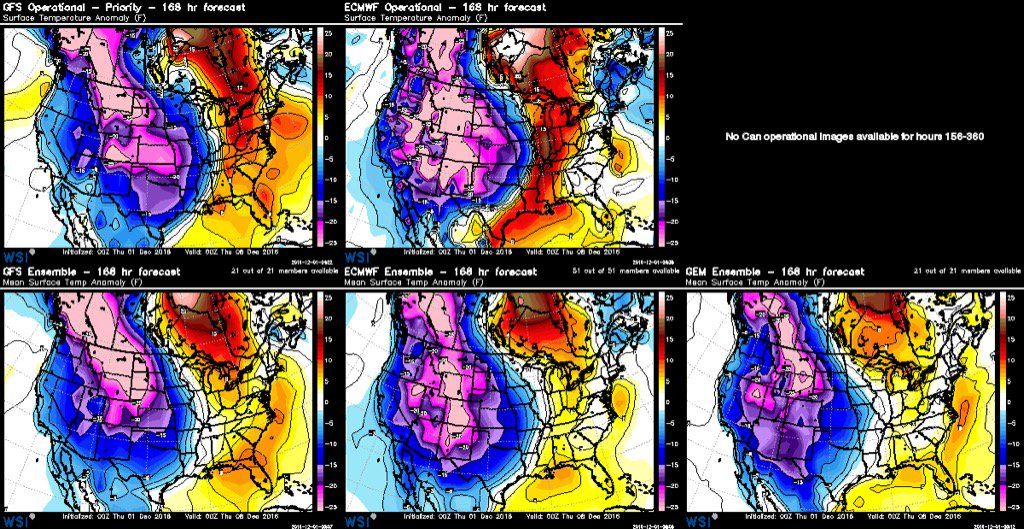
Looking over the 0z ensembles this morning, we better hope King Euro holds court over the GFS and crazy Canadian. The latter two hold more ridging over Texas and shunt the Arctic blast for next week more to the east/northeast. The Euro pretty much sends it right our way.
0 likes
Any forecasts under my name are to be taken with a grain of salt. Get your best forecasts from the National Weather Service and National Hurricane Center.
-
srainhoutx

- S2K Supporter
- Posts: 6919
- Age: 68
- Joined: Sun Jan 14, 2007 11:34 am
- Location: Haywood County, NC
- Contact:
Re: Texas Winter 2016-2017
Thursday morning briefing from Jeff:
Widespread heavy rainfall event this weekend.
Factors will rapidly come together to produce a prolonged rainfall event…some of the rainfall will be heavy.
A powerful upper level storm system currently moving toward NW MX will dive southward and then stall over NW MX Friday resulting in extensive downstream moisture return over TX on Friday. Models have sped up the timing of the incoming rain Friday evening and will insert 30% for Friday afternoon and then ramp to 70% Friday night and hold 80% through Monday. As discussed yesterday the formation and position of the coastal trough off the TX coast will make a large difference on where the heavy rains fall…and as somewhat feared model guidance has been trending to back this trough now inland over SE TX and along a line from near Freeport to Houston. This actually may bring the SE 1/3rd of the area into the warm sector with a severe and tornado threat Sunday night/Monday.
With the coastal trough now forecasted to progress more inland this will bring the threat for training heavy rainfall inland also. Will bump QPF numbers into the 4-5 inch range for much of the SE 1/3rd of the region with isolated amounts of 7 inches possible. May see two more distinct rounds of rainfall…the first Friday night into much of Saturday with the formation of the coastal trough and strong overrunning of the surface cold dome…then a slight break early Sunday…followed by the actual crossing of the upper level system late Sunday into Monday which will likely bring the most intense round of weather.
Review of flash flood guidance and NASA soil moisture satellite product shows fairly dry soil conditions over the area with 6-hr flash flood guidance over 4 inches and soil moisture around 25-35%. Think the rains Friday and Saturday will be handled and mainly go into saturating the soil. Bigger concern will come Sunday into Monday as soils become saturated and increasing run-off. This time will also feature the highest potential for excessive rainfall rates as the warm sector air mass moves inland and convection becomes more organized and sustained.
A Flash Flood Watch may be required at some point for all or portions of the area over the weekend.
Temperatures will be fairly steady in the 50’s for much of this period…the exception will be where the coastal trough moves inland and south of this boundary temperatures could easily warm into the 70’s.
Extended:
Much focus on the next 72-96 hours currently….but strong cold front looks in order still mid next week with potential area wide freeze event by late next week.
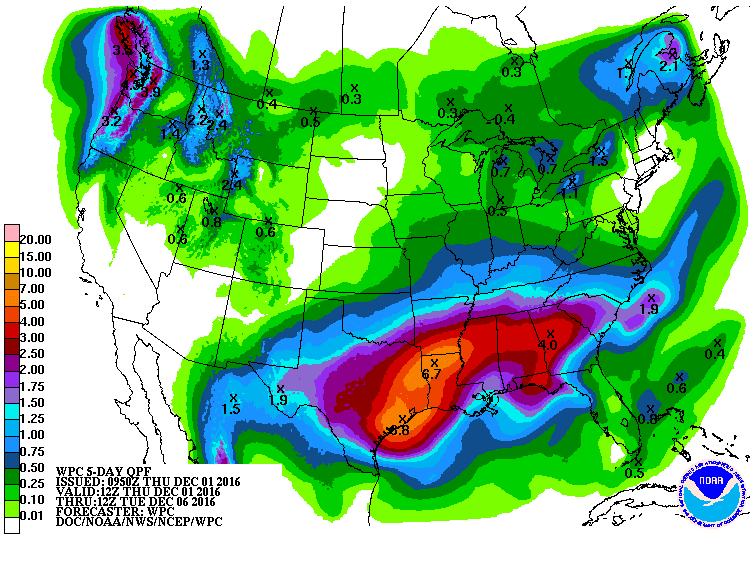
5 Day Forecasted Rainfall Totals (600am Today-600am Tuesday):
Widespread heavy rainfall event this weekend.
Factors will rapidly come together to produce a prolonged rainfall event…some of the rainfall will be heavy.
A powerful upper level storm system currently moving toward NW MX will dive southward and then stall over NW MX Friday resulting in extensive downstream moisture return over TX on Friday. Models have sped up the timing of the incoming rain Friday evening and will insert 30% for Friday afternoon and then ramp to 70% Friday night and hold 80% through Monday. As discussed yesterday the formation and position of the coastal trough off the TX coast will make a large difference on where the heavy rains fall…and as somewhat feared model guidance has been trending to back this trough now inland over SE TX and along a line from near Freeport to Houston. This actually may bring the SE 1/3rd of the area into the warm sector with a severe and tornado threat Sunday night/Monday.
With the coastal trough now forecasted to progress more inland this will bring the threat for training heavy rainfall inland also. Will bump QPF numbers into the 4-5 inch range for much of the SE 1/3rd of the region with isolated amounts of 7 inches possible. May see two more distinct rounds of rainfall…the first Friday night into much of Saturday with the formation of the coastal trough and strong overrunning of the surface cold dome…then a slight break early Sunday…followed by the actual crossing of the upper level system late Sunday into Monday which will likely bring the most intense round of weather.
Review of flash flood guidance and NASA soil moisture satellite product shows fairly dry soil conditions over the area with 6-hr flash flood guidance over 4 inches and soil moisture around 25-35%. Think the rains Friday and Saturday will be handled and mainly go into saturating the soil. Bigger concern will come Sunday into Monday as soils become saturated and increasing run-off. This time will also feature the highest potential for excessive rainfall rates as the warm sector air mass moves inland and convection becomes more organized and sustained.
A Flash Flood Watch may be required at some point for all or portions of the area over the weekend.
Temperatures will be fairly steady in the 50’s for much of this period…the exception will be where the coastal trough moves inland and south of this boundary temperatures could easily warm into the 70’s.
Extended:
Much focus on the next 72-96 hours currently….but strong cold front looks in order still mid next week with potential area wide freeze event by late next week.
5 Day Forecasted Rainfall Totals (600am Today-600am Tuesday):
1 likes
Carla/Alicia/Jerry(In The Eye)/Michelle/Charley/Ivan/Dennis/Katrina/Rita/Wilma/Ike/Harvey
Member: National Weather Association
Wx Infinity Forums
http://wxinfinity.com/index.php
Facebook.com/WeatherInfinity
Twitter @WeatherInfinity
Member: National Weather Association
Wx Infinity Forums
http://wxinfinity.com/index.php
Facebook.com/WeatherInfinity
Twitter @WeatherInfinity
-
srainhoutx
- S2K Supporter
- Posts: 6919
- Age: 68
- Joined: Sun Jan 14, 2007 11:34 am
- Location: Haywood County, NC
- Contact:
Re: Texas Winter 2016-2017
Portastorm wrote:Looking over the 0z ensembles this morning, we better hope King Euro holds court over the GFS and crazy Canadian. The latter two hold more ridging over Texas and shunt the Arctic blast more to the east/northeast. The Euro pretty much sends it right our way.
Meh...it's coming...
Michael Ventrice @MJVentrice · 19m19 minutes ago
Looking at -25F below average surface temperatures across many locations in the interior West. Models locked on.
0 likes
Carla/Alicia/Jerry(In The Eye)/Michelle/Charley/Ivan/Dennis/Katrina/Rita/Wilma/Ike/Harvey
Member: National Weather Association
Wx Infinity Forums
http://wxinfinity.com/index.php
Facebook.com/WeatherInfinity
Twitter @WeatherInfinity
Member: National Weather Association
Wx Infinity Forums
http://wxinfinity.com/index.php
Facebook.com/WeatherInfinity
Twitter @WeatherInfinity
-
gatorcane

- S2K Supporter
- Posts: 23708
- Age: 48
- Joined: Sun Mar 13, 2005 3:54 pm
- Location: Boca Raton, FL
Re: Texas Winter 2016-2017
Portastorm wrote:Looking over the 0z ensembles this morning, we better hope King Euro holds court over the GFS and crazy Canadian. The latter two hold more ridging over Texas and shunt the Arctic blast for next week more to the east/northeast. The Euro pretty much sends it right our way.
Yep, and the 06Z GFS has even more of a ridge and is warmer for Texas
0 likes
-
orangeblood
- S2K Supporter
- Posts: 3895
- Joined: Tue Dec 15, 2009 6:14 pm
- Location: Fort Worth, TX
Re: Texas Winter 2016-2017
Portastorm wrote:Looking over the 0z ensembles this morning, we better hope King Euro holds court over the GFS and crazy Canadian. The latter two hold more ridging over Texas and shunt the Arctic blast for next week more to the east/northeast. The Euro pretty much sends it right our way.
In the longer term, vast differences between the GFS/Euro and Canadian Ensembles....if the blocking over the pole continues to hold, the month of December could become extreme
GEFS

GEPS

0 likes
-
Yukon Cornelius
- S2K Supporter
- Posts: 1842
- Age: 42
- Joined: Thu Dec 20, 2012 9:23 pm
- Location: Dean, TX/Westcliffe, CO
Re: Texas Winter 2016-2017
I may be the only one not looking forward to the rain but am definitely ready for the cold. Firewood cut, hay ready to be fed and water wells have all been protected. Bring it on!
0 likes
#neversummer
-
1900hurricane

- Category 5

- Posts: 6063
- Age: 34
- Joined: Fri Feb 06, 2015 12:04 pm
- Location: Houston, TX
- Contact:
Re: Texas Winter 2016-2017
0 likes
Contract Meteorologist. TAMU & MSST. Fiercely authentic, one of a kind. We are all given free will, so choose a life meant to be lived. We are the Masters of our own Stories.
Opinions expressed are mine alone.
Follow me on Twitter at @1900hurricane : Read blogs at https://1900hurricane.wordpress.com/
Opinions expressed are mine alone.
Follow me on Twitter at @1900hurricane : Read blogs at https://1900hurricane.wordpress.com/

Re: Texas Winter 2016-2017
Portastorm wrote:Looking over the 0z ensembles this morning, we better hope King Euro holds court over the GFS and crazy Canadian. The latter two hold more ridging over Texas and shunt the Arctic blast for next week more to the east/northeast. The Euro pretty much sends it right our way.
GEFS does not support the OP, while there is some transition before the next arctic outbreak (yes I believe there will be shortly after this first one) anomalies remain below normal. This is what happens when you keep Western Canada in the icebox, it presses and pours even in face of zonal flow underneath. I would agree with the GFS if the cold air was on the other side of the globe. But because of the Aleutian ridge, this side of the globe source region remains flow from the north.
Not to mention how wacky the GFS has been anyway beyond 198 hours. Just take a look at the last 6 runs. Ridge, ridge, ridge....trough..I mean really? Euro nailed this coming arctic outbreak first within reason..don't even ask me what the GFS was doing then.

0 likes
The above post and any post by Ntxw is NOT an official forecast and should not be used as such. It is just the opinion of the poster and may or may not be backed by sound meteorological data. It is NOT endorsed by any professional institution including Storm2k. For official information, please refer to NWS products.
Help support Storm2K!
-
TeamPlayersBlue

- Category 5
- Posts: 3533
- Joined: Tue Feb 02, 2010 1:44 am
- Location: Denver/Applewood, CO
Re: Texas Winter 2016-2017
It appears the GFS has a stronger upper level high east of Hawaii in the last few runs. This high builds in some ridging and keeps the trough from really digging into Texas.
0 likes
Personal Forecast Disclaimer:
The posts in this forum are NOT official forecast and should not be used as such. They are just the opinion of the poster and may or may not be backed by sound meteorological data. They are NOT endorsed by any professional institution or storm2k.org. For official information, please refer to the NHC and NWS products.
The posts in this forum are NOT official forecast and should not be used as such. They are just the opinion of the poster and may or may not be backed by sound meteorological data. They are NOT endorsed by any professional institution or storm2k.org. For official information, please refer to the NHC and NWS products.
-
aggiecutter
- Category 5
- Posts: 1755
- Joined: Thu Oct 14, 2004 9:22 pm
- Location: Texarkana
Re: Texas Winter 2016-2017
TeamPlayersBlue wrote:It appears the GFS has a stronger upper level high east of Hawaii in the last few runs. This high builds in some ridging and keeps the trough from really digging into Texas.
The cold dense air will win out. See NTX post above.
1 likes
-
TeamPlayersBlue
- Category 5
- Posts: 3533
- Joined: Tue Feb 02, 2010 1:44 am
- Location: Denver/Applewood, CO
Re: Texas Winter 2016-2017
Agreed, i think it would be even better if the trough came down into Texas though
0 likes
Personal Forecast Disclaimer:
The posts in this forum are NOT official forecast and should not be used as such. They are just the opinion of the poster and may or may not be backed by sound meteorological data. They are NOT endorsed by any professional institution or storm2k.org. For official information, please refer to the NHC and NWS products.
The posts in this forum are NOT official forecast and should not be used as such. They are just the opinion of the poster and may or may not be backed by sound meteorological data. They are NOT endorsed by any professional institution or storm2k.org. For official information, please refer to the NHC and NWS products.
-
aggiecutter
- Category 5
- Posts: 1755
- Joined: Thu Oct 14, 2004 9:22 pm
- Location: Texarkana
Re: Texas Winter 2016-2017
TeamPlayersBlue wrote:Agreed, i think it would be even better if the trough came down into Texas though
It wont matter. See below. This is a classic set-up for very cold air into Texas and much of the lower 48. Blocking over the top, broad trough over the northern-central plains down into southern plains, with very cold over NW North America. The dense cold air will drain into the trough and the sheer weight of it will take it all the way to Mexico.

The posts in this forum are NOT official forecast and should not be used as such. They are just the opinion of the poster and may or may not be backed by sound meteorological data. They are NOT endorsed by any professional institution or STORM2K
0 likes
Re: Texas Winter 2016-2017
I think overall December will average a little colder than normal. To get really cold, that little bugger "polar vortex" over the Davis strait would move further south a bit and all that ridging over the NPAC shifts a little east. Then you'd have katy bar the door, but as it is chunks and pieces of the cold over WCanada bleeds. To be honest, the 500mb pattern next week isn't that great for an arctic outbreak, but because the air mass is cold, it's a fairly decent event for early December.
1 likes
The above post and any post by Ntxw is NOT an official forecast and should not be used as such. It is just the opinion of the poster and may or may not be backed by sound meteorological data. It is NOT endorsed by any professional institution including Storm2k. For official information, please refer to NWS products.
Help support Storm2K!
Help support Storm2K!
-
CaptinCrunch

- S2K Supporter
- Posts: 8783
- Age: 58
- Joined: Mon Nov 03, 2003 4:33 pm
- Location: Kennedale, TX (Tarrant Co.)
Re: Texas Winter 2016-2017
Welcome December! and good bye to the Record warmest Fall ever recorded for NTX. If you didn't catch it on any of the local news weather reports Sept, Oct and Nov were all warmest months on record for NTX, putting Fall 2016 in as the warmest Fall ever since 1899 when records started being kept (117 yrs)
Well no freeze here at the house this morning, lowest it got was 34, but there was plenty of frost on everything. Again a lot of places outside the Dallas/Tarrant County area probably got down to 32 briefly, and I expect close to the same again in the morning if the clouds don't start rolling in over night, but we should get that official 1st freeze next Thursday or Friday.
Well no freeze here at the house this morning, lowest it got was 34, but there was plenty of frost on everything. Again a lot of places outside the Dallas/Tarrant County area probably got down to 32 briefly, and I expect close to the same again in the morning if the clouds don't start rolling in over night, but we should get that official 1st freeze next Thursday or Friday.
0 likes
-
Tireman4

- S2K Supporter
- Posts: 5904
- Age: 60
- Joined: Fri Jun 30, 2006 1:08 pm
- Location: Humble, Texas
- Contact:
Re: Texas Winter 2016-2017
HGX AFD this morning..
000
FXUS64 KHGX 011124
AFDHGX
Area Forecast Discussion
National Weather Service Houston/Galveston TX
524 AM CST Thu Dec 1 2016
.DISCUSSION...
The cold/dry morning should give way to perhaps our last quiet wx
day...especially when compared to the upcoming forecast for these
next several days. Models remain in generally good agreement with
the prospects of periodic episodes of rain developing across much
of SE TX starting tomorrow (spreading from the SW) on through the
weekend. Low-level moisture progged to increase dramatically with
the strengthening onshore winds tomorrow...in response to the up-
per trof that will begin to deepen near the California Baja. This
system is expected to close off to a rather discrete upper low as
it moves east across northern Mexico into South Central TX on Sat.
An increasingly deep SW flow aloft will help to draw disturbances
across the state via the upper jet to help fuel widespread shower
activity. Rainfall could be further enhanced Sat/Sat night with a
coastal surface trof developing near/just off the lower/middle TX
coast. Very high PWs associated with this system (1.8"-2.0") will
be a concern regarding the potential for heavy rains. However the
heavy rain threat will likely be highly dependent on the track of
this coastal trof. And then to top it all off there is the poten-
tial for storms Mon as the main upper low moves across the region
(with a slight negative tilt and favorable upper jet position).
Perhaps a bit of a break from the rain on Tue, but the prevailing
SW flow aloft (with the longwave trof axis still to our west) may
help to keep some clouds in the area. Extended guidance indicates
a return of low POPS as a rather strong cold front sweeps through
next Wed/Thur. 41
&&
.MARINE...
NNE-NE winds this morning should gradually come around to the east
as high pressure over SETX drifts into LA. Seas should drop slightly
before beginning to build again as gradient tightens Friday. Over
the weekend pressures fall along the South Texas coast and moderate
to strong easterly flow forms with another round of hazardous seas
developing. Easterly flow will encourage higher tide levels and
increasing seas with runup should aggravate tide levels further.
SCEC/SCA conditions should be on tap Friday through Monday. Strong
thunderstorms over the coastal waters also a good possibility with
impressive shear and greater instability. Eventually (depending on
speed of the low`s departure) dry westerly flow wraps around the
system as it swings out to the east Monday or Monday night. Track of
the low will also dictate the location of the stationary/warm front
with it either onshore or over the nearshore waters Sunday and
Sunday night.
45
&&
.Aviation...
VFR with winds veering from light NE to E today. Some patchy fog may
be possible around LBX Friday morning. Over the weekend most sites
will be experiencing an extended period of low cigs/reduced
visibility and a mix of rain/showers/thunderstorms and enhanced
easterly winds.
45
&&
.PRELIMINARY POINT TEMPS/POPS...
College Station (CLL) 65 46 65 53 58 / 0 10 30 70 80
Houston (IAH) 67 47 64 55 65 / 0 10 30 70 80
Galveston (GLS) 65 58 70 66 68 / 0 10 50 70 80
&&
.HGX WATCHES/WARNINGS/ADVISORIES...
TX...NONE.
GM...NONE.
&&
$$
Discussion...99
0 likes
-
Portastorm
- Storm2k Moderator
- Posts: 9955
- Age: 63
- Joined: Fri Jul 11, 2003 9:16 am
- Location: Round Rock, TX
- Contact:
Re: Texas Winter 2016-2017
... that moment when you see all the regulars on Storm2K crowing about an Arctic outbreak into Texas, each sharing some good insights ...

3 likes
Any forecasts under my name are to be taken with a grain of salt. Get your best forecasts from the National Weather Service and National Hurricane Center.
-
starsfan65

- Category 2

- Posts: 738
- Age: 48
- Joined: Thu Dec 17, 2015 1:18 pm
- Location: Garland,Tx
-
TeamPlayersBlue
- Category 5
- Posts: 3533
- Joined: Tue Feb 02, 2010 1:44 am
- Location: Denver/Applewood, CO
Re: Texas Winter 2016-2017
Aggiecutter: Cold, i agree! I hope youre right that we will get just as much. Precip? That goes away though right?`
0 likes
Personal Forecast Disclaimer:
The posts in this forum are NOT official forecast and should not be used as such. They are just the opinion of the poster and may or may not be backed by sound meteorological data. They are NOT endorsed by any professional institution or storm2k.org. For official information, please refer to the NHC and NWS products.
The posts in this forum are NOT official forecast and should not be used as such. They are just the opinion of the poster and may or may not be backed by sound meteorological data. They are NOT endorsed by any professional institution or storm2k.org. For official information, please refer to the NHC and NWS products.
-
Ralph's Weather
- S2K Supporter
- Posts: 3374
- Age: 38
- Joined: Fri Dec 13, 2013 11:55 am
- Location: Lindale, TX
- Contact:
Re: Texas Winter 2016-2017
Watching the 12Z GFS coming in and at first glance it appears that there may be some flurries behind the front on Wed with a little pulse behind the front. This will change, but the idea of something wringing out some moisture is definitely on the table at least. Also there is not much warm up between this weekend and the front coming through, maybe getting close to 60 Mon and Tue. This is because we will be on the backside of this weekend's system's surface low so we never get the southerly flow that usually causes a warm up right before a front.
0 likes
Follow on Facebook at Ralph's Weather.
Who is online
Users browsing this forum: No registered users and 144 guests