Texas Winter 2015-2016

Winter Weather Discussion

Moderator: S2k Moderators

Forum rules

The posts in this forum are NOT official forecast and should not be used as such. They are just the opinion of the poster and may or may not be backed by sound meteorological data. They are NOT endorsed by any professional institution or STORM2K.

Help Support Storm2K
Message
Author
User avatar
JDawg512
Category 5
Category 5
Posts: 1075
Age: 45
Joined: Mon Aug 26, 2013 8:56 pm
Location: Austin
Contact:

Re: Texas Winter 2015-2016

#141 Postby JDawg512 » Sat Dec 05, 2015 1:45 am

Ntxw wrote:
Texas Snowman wrote:From Fort Worth NWS. Notice the rainfall at Gainesville - the most ever recorded in North Texas.

Yup, 2015 (summer drought and all) has definitely been one for the books...and then some.

Take a good, hard, long look and remember this year. It's one for the ages in weather lore. It might be the only time in most of our lives that we get to see something like this.

http://www.srh.noaa.gov/images/fxc/fwd/ ... _full7.jpg


Only 1957 comes close to the scope of rains that have fallen over Texas this year. Though 1957 was lackluster in the fall unlike 2015. The El Nino as of today came in with it's first official trimonthly of 2C. The next will be higher. It's official by all measures you can now call it the Super El Nino of 2015. We will look back some years from now when it's high and dry and understand how when the skies opened up, it poured and poured. So that we will remember, the desertification of Texas can't happen now or anytime in the near feature. Because El Nino's happen and are cyclical. It is a part of our climate and the Pacific is the great modulator that swings the pendulum back and forth in the biggest weather machine that effects Texas. They won't stop happening 50 years from now or 500 years.


Well yes, cycles will continue but that doesn't mean things will stay the same. With increased evaporation, we will need more rainfall to keep up with soil moisture as well as water flow into rivers and lakes. What is evident in with my observation (and I'm definitely not the only one that sees this) is that the weather is becoming more extreme on both ends of the spectrum and that will most definitely get worse over the next 50 plus years.

One thing that some scientists are bringing up is the ocean temps world wide are warmer, how does that impact the El Niño cycle in today's world as opposed to past El Niños? We also just saw the inactive phase of the MJO occure. That is unusual in that the MJO should be non existent during an El Niño let alone a Super El Niño because the El Niño base state takes control. So why are we seeing MJO phases? That is a head scratcher for sure.

So yea the cycles will continue for the long term but there are other climate cycles and factors to take into consideration that may very well alter how El Niño affects the atmosphere and how it impacts different regions around the planet.

My research is focused on future trends and so far I don't really like what I see.


But all that aside, it's an interesting debate nonetheless and I look forward to many facenating discussions and exciting weather events. I noticed the site was down for several hours so was relieved when I tried just a bit ago and it came up.

Hope everyone is enjoying this beautiful weather. I've been able to get quite a lot of yard work done and I'm so glad I've been able to do it considering that there may not be many more opportunities as we head further into winter.
0 likes   
Resident Rain Miser

I am a weather hobbyist living 3.5 miles south of Downtown Austin and in no way or fashion should anything I say concerning forecasts be taken seriously. Please check your local NWS for accurate weather forecasting and conditions.

Brent
S2K Supporter
S2K Supporter
Posts: 38087
Age: 36
Joined: Sun May 16, 2004 10:30 pm
Location: Tulsa Oklahoma
Contact:

Re: Texas Winter 2015-2016

#142 Postby Brent » Sat Dec 05, 2015 2:43 am

GFS still hinting on and off at some frozen fun(at least colder and more unsettled weather) the week before Christmas, it turns colder and stormier sometime next weekend:

Image

The Euro has a cold shot behind a storm next weekend too:

Image
0 likes   
#neversummer

Ralph's Weather
S2K Supporter
S2K Supporter
Posts: 3269
Age: 38
Joined: Fri Dec 13, 2013 11:55 am
Location: Lindale, TX
Contact:

#143 Postby Ralph's Weather » Sat Dec 05, 2015 7:53 am

Next week should be about the warmest period of the winter and we may hit 70 once or twice. In this week's fairly torchy pattern I have had I think 4 consecutive freezes.
0 likes   
Follow on Facebook at Ralph's Weather.

User avatar
TheProfessor
Professional-Met
Professional-Met
Posts: 3506
Age: 28
Joined: Tue Dec 03, 2013 10:56 am
Location: Wichita, Kansas

#144 Postby TheProfessor » Sat Dec 05, 2015 9:07 am

I like the end of the 6z GFS. :D
0 likes   
An alumnus of The Ohio State University.

Your local National Weather Service office is your best source for weather information.

User avatar
wxman57
Moderator-Pro Met
Moderator-Pro Met
Posts: 22976
Age: 67
Joined: Sat Jun 21, 2003 8:06 pm
Location: Houston, TX (southwest)

Re:

#145 Postby wxman57 » Sat Dec 05, 2015 9:32 am

TheProfessor wrote:I like the end of the 6z GFS. :D


Yeah, you can certainly count on the 384-hr panel of the GFS always being correct. ;-)
0 likes   

User avatar
Portastorm
Storm2k Moderator
Storm2k Moderator
Posts: 9914
Age: 63
Joined: Fri Jul 11, 2003 9:16 am
Location: Round Rock, TX
Contact:

Re:

#146 Postby Portastorm » Sat Dec 05, 2015 9:33 am

TheProfessor wrote:I like the end of the 6z GFS. :D


Ha ha! I bet you do. :wink:

My takeaway from the last few GFS runs is that about mid month we're going to start seeing more frequent shots of colder air from up north and a mean storm track digging deeper and deeper into the Southern Plains/Texas. If that verifies, there might be some happy campers in north Texas close to Christmas.
0 likes   
Any forecasts under my name are to be taken with a grain of salt. Get your best forecasts from the National Weather Service and National Hurricane Center.

User avatar
TheProfessor
Professional-Met
Professional-Met
Posts: 3506
Age: 28
Joined: Tue Dec 03, 2013 10:56 am
Location: Wichita, Kansas

Re: Re:

#147 Postby TheProfessor » Sat Dec 05, 2015 9:59 am

wxman57 wrote:
TheProfessor wrote:I like the end of the 6z GFS. :D


Yeah, you can certainly count on the 384-hr panel of the GFS always being correct. ;-)


No, but it's till fun to look at, a guy can dream can't he? :D

PS: Who makes the smilies here? I think they should make one where you can see the eye's move up and then little clouds come out to resemble dreaming lol.
0 likes   
An alumnus of The Ohio State University.

Your local National Weather Service office is your best source for weather information.

User avatar
Ntxw
Storm2k Moderator
Storm2k Moderator
Posts: 22783
Joined: Wed Oct 21, 2009 6:34 pm
Location: DFW, Texas

Re: Texas Winter 2015-2016

#148 Postby Ntxw » Sat Dec 05, 2015 10:38 am


One thing that some scientists are bringing up is the ocean temps world wide are warmer, how does that impact the El Niño cycle in today's world as opposed to past El Niños? We also just saw the inactive phase of the MJO occure. That is unusual in that the MJO should be non existent during an El Niño let alone a Super El Niño because the El Niño base state takes control. So why are we seeing MJO phases? That is a head scratcher for sure.

So yea the cycles will continue for the long term but there are other climate cycles and factors to take into consideration that may very well alter how El Niño affects the atmosphere and how it impacts different regions around the planet.

My research is focused on future trends and so far I don't really like what I see.


But all that aside, it's an interesting debate nonetheless and I look forward to many facenating discussions and exciting weather events. I noticed the site was down for several hours so was relieved when I tried just a bit ago and it came up.

Hope everyone is enjoying this beautiful weather. I've been able to get quite a lot of yard work done and I'm so glad I've been able to do it considering that there may not be many more opportunities as we head further into winter.


I have only noticed going back on rain data for multiple sites is that El Nino's are getting wetter. 1991, 1994, 1997, 2002, 2004, 2009, 2015 are all amongst very wet (most are at the top) years and are all the most recent El Ninos. We haven't seen a below normal rainfall Nino year since the 1987 even. In fact most Nino's of the 70s and 80s were quite dry.

Edit: forgot 2006-2007!
0 likes   
The above post and any post by Ntxw is NOT an official forecast and should not be used as such. It is just the opinion of the poster and may or may not be backed by sound meteorological data. It is NOT endorsed by any professional institution including Storm2k. For official information, please refer to NWS products.

  Help support Storm2K!
Help Support Storm2K

User avatar
Tireman4
S2K Supporter
S2K Supporter
Posts: 5853
Age: 59
Joined: Fri Jun 30, 2006 1:08 pm
Location: Humble, Texas
Contact:

Re: Re:

#149 Postby Tireman4 » Sat Dec 05, 2015 2:12 pm

wxman57 wrote:
TheProfessor wrote:I like the end of the 6z GFS. :D


Yeah, you can certainly count on the 384-hr panel of the GFS always being correct. ;-)[/quote]


Yeah...if it were forecasting 90's...you would say...spot on...lol
0 likes   

User avatar
dhweather
S2K Supporter
S2K Supporter
Posts: 6199
Joined: Sat Aug 14, 2004 9:29 pm
Location: Heath, TX
Contact:

#150 Postby dhweather » Sat Dec 05, 2015 3:30 pm

12Z GFS has no temps below freezing through 384 hours in the Mesquite area.
0 likes   
The above post and any post by dhweather is NOT an official forecast and should not be used as such. It is just the opinion of the poster and may or may not be backed by sound meteorological data. It is NOT endorsed by any professional institution including storm2k.org. For official information, please refer to NWS products.

User avatar
hriverajr
Professional-Met
Professional-Met
Posts: 786
Joined: Tue Jul 19, 2005 12:16 am

Re: Texas Winter 2015-2016

#151 Postby hriverajr » Sat Dec 05, 2015 7:19 pm

I trust absolutely nothing past 270. Nothing really exciting in the forseeable future though
0 likes   
Anything I post is my personal opinion and should not used for any type of planning or lifesaving reasons. Please refer to National Weather Service forecasts.

User avatar
Portastorm
Storm2k Moderator
Storm2k Moderator
Posts: 9914
Age: 63
Joined: Fri Jul 11, 2003 9:16 am
Location: Round Rock, TX
Contact:

Re: Texas Winter 2015-2016

#152 Postby Portastorm » Sat Dec 05, 2015 7:51 pm

Ntxw wrote:

One thing that some scientists are bringing up is the ocean temps world wide are warmer, how does that impact the El Niño cycle in today's world as opposed to past El Niños? We also just saw the inactive phase of the MJO occure. That is unusual in that the MJO should be non existent during an El Niño let alone a Super El Niño because the El Niño base state takes control. So why are we seeing MJO phases? That is a head scratcher for sure.

So yea the cycles will continue for the long term but there are other climate cycles and factors to take into consideration that may very well alter how El Niño affects the atmosphere and how it impacts different regions around the planet.

My research is focused on future trends and so far I don't really like what I see.


But all that aside, it's an interesting debate nonetheless and I look forward to many facenating discussions and exciting weather events. I noticed the site was down for several hours so was relieved when I tried just a bit ago and it came up.

Hope everyone is enjoying this beautiful weather. I've been able to get quite a lot of yard work done and I'm so glad I've been able to do it considering that there may not be many more opportunities as we head further into winter.


I have only noticed going back on rain data for multiple sites is that El Nino's are getting wetter. 1991, 1994, 1997, 2002, 2004, 2009, 2015 are all amongst very wet (most are at the top) years and are all the most recent El Ninos. We haven't seen a below normal rainfall Nino year since the 1987 even. In fact most Nino's of the 70s and 80s were quite dry.

Edit: forgot 2006-2007!


Interesting comments here. I'm not sure I buy the notion though that a strong MJO cannot exist during an El Niño. I believe that is only true during strong Ninos. A strong MJO signal can and does enhance weak/moderate Ninos.
0 likes   
Any forecasts under my name are to be taken with a grain of salt. Get your best forecasts from the National Weather Service and National Hurricane Center.

User avatar
TeamPlayersBlue
Category 5
Category 5
Posts: 3445
Joined: Tue Feb 02, 2010 1:44 am
Location: Denver/Applewood, CO

#153 Postby TeamPlayersBlue » Sat Dec 05, 2015 8:40 pm

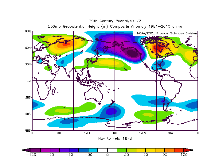
500MB for 1877
Image

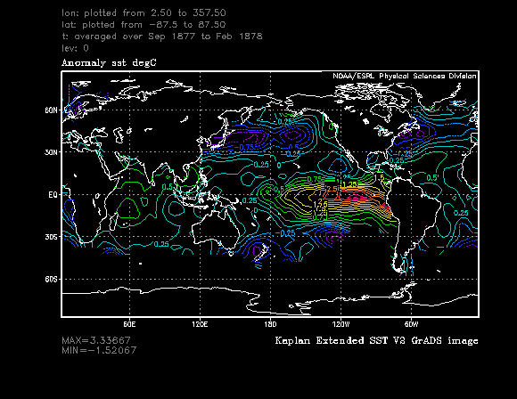
SST for 1877Image

Link about the "Winter Without a Winter" in Minnesota during 1877-1878.
http://climate.umn.edu/doc/journal/wint77_78.html
Got really bored, plus i like working/looking at stuff on my mac during football.

In comparison of 77-78 to now, it looks like my high pressure is much further east then it shows in their analysis. Not sure how accurate the analysis' are, but take it for what it's worth. The SST dont look entirely that different from what we are experiencing now, except warm water off the California Coast.
0 likes   
Personal Forecast Disclaimer:
The posts in this forum are NOT official forecast and should not be used as such. They are just the opinion of the poster and may or may not be backed by sound meteorological data. They are NOT endorsed by any professional institution or storm2k.org. For official information, please refer to the NHC and NWS products.

User avatar
Ntxw
Storm2k Moderator
Storm2k Moderator
Posts: 22783
Joined: Wed Oct 21, 2009 6:34 pm
Location: DFW, Texas

#154 Postby Ntxw » Sat Dec 05, 2015 10:04 pm

There are more guidance slowly pointing at a negative possibilities for AO. Still wait and see approach for any AO forecasts. Stratosphere polar vortex is still very strong but there is attacks continuing. Some warming in the far east of the more dramatic fashion. Need the explosive warmth to reach the polar region. Still though at least this is setting up shop for later. Much like last year it took till the end of the month into the first week of January for the AO to respond.

Image

I think it's becoming clear we are not following 2009-2010, 1963-1964. Perhaps 1965, 1982, 1987. Refer back to first page on the climo of Nino's. December is fitting the mold quite nicely.

To start December though many sites in Texas are slightly below normal.

Through first five days of December

Image
0 likes   
The above post and any post by Ntxw is NOT an official forecast and should not be used as such. It is just the opinion of the poster and may or may not be backed by sound meteorological data. It is NOT endorsed by any professional institution including Storm2k. For official information, please refer to NWS products.


  Help support Storm2K!

Help Support Storm2K


Brent
S2K Supporter
S2K Supporter
Posts: 38087
Age: 36
Joined: Sun May 16, 2004 10:30 pm
Location: Tulsa Oklahoma
Contact:

Re: Texas Winter 2015-2016

#155 Postby Brent » Sun Dec 06, 2015 1:35 am

GFS at 0z much colder starting at around 240 hours... mid 20s at DFW and highs in the lower 40s.
0 likes   
#neversummer

User avatar
Ntxw
Storm2k Moderator
Storm2k Moderator
Posts: 22783
Joined: Wed Oct 21, 2009 6:34 pm
Location: DFW, Texas

#156 Postby Ntxw » Sun Dec 06, 2015 11:30 am

12 GFS is digging next weekend's potential storm (the trof we have been discussing with -PNA) very far to the south and is a bowling ball type low. The further south solution would definitely present much more qpf not to mention a trowal and snow on it's other side. Could be the first real deal major winter storm of sort for the state. There won't be much surface cold, it would have to come from above though at least not yet from this range. But it will be cold aloft due to the much lower heights.

This is the kind of pattern that was set up in some of the surprise events such as Christmas eve 09 and a few other bowling ball type events. Euro has the same kind of track as well. Track is key. I've been following the lower heights depiction by the ensembles and I like what I am seeing, especially when we get closer and into the resolution of the better globals.
0 likes   
The above post and any post by Ntxw is NOT an official forecast and should not be used as such. It is just the opinion of the poster and may or may not be backed by sound meteorological data. It is NOT endorsed by any professional institution including Storm2k. For official information, please refer to NWS products.


  Help support Storm2K!

Help Support Storm2K


Brent
S2K Supporter
S2K Supporter
Posts: 38087
Age: 36
Joined: Sun May 16, 2004 10:30 pm
Location: Tulsa Oklahoma
Contact:

Re: Texas Winter 2015-2016

#157 Postby Brent » Sun Dec 06, 2015 12:40 pm

:eek:

and its not a million hours out

Image
0 likes   
#neversummer

User avatar
TeamPlayersBlue
Category 5
Category 5
Posts: 3445
Joined: Tue Feb 02, 2010 1:44 am
Location: Denver/Applewood, CO

#158 Postby TeamPlayersBlue » Sun Dec 06, 2015 12:53 pm

Just saw the GFS, looks fairly promising for you guys in North Texas. Hopefully the track stays south. Might end up being a panhandle hooker type of storm but im pulling for you guys!
0 likes   
Personal Forecast Disclaimer:
The posts in this forum are NOT official forecast and should not be used as such. They are just the opinion of the poster and may or may not be backed by sound meteorological data. They are NOT endorsed by any professional institution or storm2k.org. For official information, please refer to the NHC and NWS products.

User avatar
JDawg512
Category 5
Category 5
Posts: 1075
Age: 45
Joined: Mon Aug 26, 2013 8:56 pm
Location: Austin
Contact:

Re: Texas Winter 2015-2016

#159 Postby JDawg512 » Sun Dec 06, 2015 3:08 pm

Portastorm wrote:
Ntxw wrote:

One thing that some scientists are bringing up is the ocean temps world wide are warmer, how does that impact the El Niño cycle in today's world as opposed to past El Niños? We also just saw the inactive phase of the MJO occure. That is unusual in that the MJO should be non existent during an El Niño let alone a Super El Niño because the El Niño base state takes control. So why are we seeing MJO phases? That is a head scratcher for sure.

So yea the cycles will continue for the long term but there are other climate cycles and factors to take into consideration that may very well alter how El Niño affects the atmosphere and how it impacts different regions around the planet.

My research is focused on future trends and so far I don't really like what I see.


But all that aside, it's an interesting debate nonetheless and I look forward to many facenating discussions and exciting weather events. I noticed the site was down for several hours so was relieved when I tried just a bit ago and it came up.

Hope everyone is enjoying this beautiful weather. I've been able to get quite a lot of yard work done and I'm so glad I've been able to do it considering that there may not be many more opportunities as we head further into winter.


I have only noticed going back on rain data for multiple sites is that El Nino's are getting wetter. 1991, 1994, 1997, 2002, 2004, 2009, 2015 are all amongst very wet (most are at the top) years and are all the most recent El Ninos. We haven't seen a below normal rainfall Nino year since the 1987 even. In fact most Nino's of the 70s and 80s were quite dry.

Edit: forgot 2006-2007!


Interesting comments here. I'm not sure I buy the notion though that a strong MJO cannot exist during an El Niño. I believe that is only true during strong Ninos. A strong MJO signal can and does enhance weak/moderate Ninos.


Your right in that the MJO can and does influence weak and moderate Niños but of course can also dampen them when it goes into the inactive phase which is what happened earlier in November. Check out the 30 and 90 day running -SOI numbers which went from the -19s down to the -12s and -13s. The numbers are starting to drop again but seeing as how this Niño should be nearing it's peak, it's unusual to see such low negative numbers for what is very likely a Super El Niño albeit a different flavor if you will compared to 97. From what I've read, this is unusual for the MJO to be occurring at this stage in the game when the niño base state should be in full control.


Also to what Ntxw pointed out Niño's have gotten wetter compared to 40-50 years ago. That is to be expected given that the overall ocean temps have risen and as a result more moisture is evaporating into the atmosphere. Actually there are a few climate models that indicate that we could very well get wetter overall in yearly average between now and 2100 and believe me, I would like nothing more for that to be the case. However, it's fairly evenly split down the middle with models showing we will start to get drier. Personally, I'm leaning towards overall wetter but with large swings of extreme droughts mixed in, more extreme than we have seen in the past. It would be ideal if we would have a more even distribution of rainfall throughout the year rather than 6 inches one month then almost nothing for two months then 10 or 15 inches the month after. That really isn't helpful in the long term.

One of the things I'd like to get to since weather is my hobby but need to find the time between my animation work schedule is to take a good look at data going back. I've gone over some historical analogs but not nearly as many as I'd like.


Back to current events, I've noticed that there are temps near 80 in the forecast. :double:

For an El Niño December, we aren't seeing very El Niño like weather..
0 likes   
Resident Rain Miser

I am a weather hobbyist living 3.5 miles south of Downtown Austin and in no way or fashion should anything I say concerning forecasts be taken seriously. Please check your local NWS for accurate weather forecasting and conditions.

User avatar
Ntxw
Storm2k Moderator
Storm2k Moderator
Posts: 22783
Joined: Wed Oct 21, 2009 6:34 pm
Location: DFW, Texas

Re: Texas Winter 2015-2016

#160 Postby Ntxw » Sun Dec 06, 2015 3:19 pm

JDawg512 wrote:For an El Niño December, we aren't seeing very El Niño like weather..


It is very El Nino like actually. Especially for the Super Nino's. December is not a cold month North America is often flooded with warmth as seen and the Pacific NW is be blasted by heavy rain as with the extended Pacific jet in +ENSO. Again remember to look back at page 1 where I did a composite of the strong Nino signals. We like to think of the wet and cold Decembers like 2009 is El Nino but actually that was a freak anomaly of the AO. La Nina's are often the cold Decembers like 1983.


We have to be very careful when using Nino/Nina for day to day and sometimes even weekly weather patterns. it is a seasonal forecasting tool, just look back at October and the year as a whole. Eventually the +precipitation anomalies won out thanks to the background low frequency effects of ENSO. Amongst other things that controls day to day weather.

The latest interesting thing for me is, at it's current strength the Nino may not fade as quickly as anticipated. We may see these +rain anomalies extend through spring of next year...that is a very good sign.
0 likes   
The above post and any post by Ntxw is NOT an official forecast and should not be used as such. It is just the opinion of the poster and may or may not be backed by sound meteorological data. It is NOT endorsed by any professional institution including Storm2k. For official information, please refer to NWS products.


  Help support Storm2K!

Help Support Storm2K


Return to “Winter Weather”

Who is online

Users browsing this forum: No registered users and 12 guests