The posts in this forum are NOT official forecast and should not be used as such. They are just the opinion of the poster and may or may not be backed by sound meteorological data. They are NOT endorsed by any professional institution or


On December the 22nd at around 7:35AM Portastorm wrote this after an extensive day of model stalking.
Portastorm wrote:As its looking right now and based on the GFS, Euro, and CMC ... the only part of Texas who might see snow for Christmas would be the upper half of the Panhandle. A few flakes might even fall as east as Vernon but that would be it.
For the rest of us, it'll be cold and breezy on Christmas Eve and Christmas with high temps about 10-15 degrees below normal. The 0z CMC still suggests a slight possibility of precip encroaching on southern Texas over the weekend but it remains the outlier.
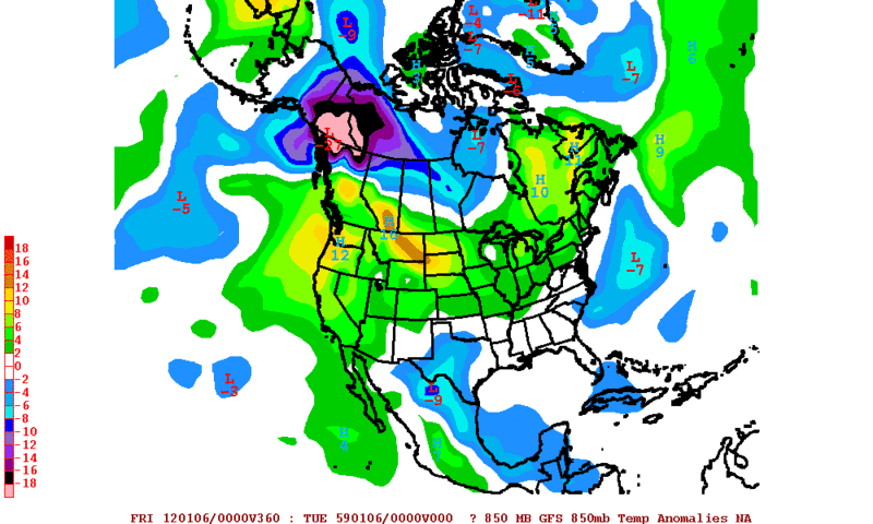
The longer-range Euro from the 0z run is interesting in that it shows an active Southern jet cranking up. Really for the last two weeks or so the southern jet has not been much of a factor in our weather. That appears about to change. Now if we could only combine that with a cold-enough airmass (Portastorm lapses into dreaming).
On the 21st
iorange55 wrote:To be fair there is a chance that places like Wichita Falls, tx and around the red river there could be some snow, it's not impossible and will probably happen. But saying that I don't see anywhere near 6-10 inches or even 2-4 inches really. Wichita Falls maybe an inch, or so. Red River maybe a dusting, or just flurries. It's possible for the red river and Wichita Falls area to get some, just not to that extreme, or even close. I don't believe abilene, and places that south in West Texas we'll see any, but further to the north possibly.
And a conversion between Portastorm and myself!
Portastorm wrote:Ntxw wrote:Well so far the 0z gfs puts the low still north. Even Oklahoma doesn't look to get too much wintry stuff (except maybe in the far northern sections).
Right you are Ntxw! Both the 0z GFS and Euro show the low moving further north than before. The area of Oklahoma previously thought to get some snow would be essentially dry slotted.