Even if soil is still warm...another thread about soil temps. showed that warm soil would cause little to no effect on air temperature. Plus, I think that they are back to normal. In that same thread I learned that the soil recovers quite quickly and it only takes a few cool nights...last night was 34...I think that is pretty cool...and the night before was in the 30s as well. Overall though, I think you make good points and your forecast sounds pretty good. Middle 20s north of IAH is a lot better than the 30 forecasted by the NWS..but still not as cold as I think there is potential for the air to go. We'll see... Can't wait to see how the models trend tomorrow.vbhoutex wrote:Extremeweatherguy wrote:I do not understand what coming off a warm January has to do with it? We have had a few nights here lately below 40, and that is enough to cool soil back to normal..and other than that...there is nothing that a warm Jan. could do to warm the air. As for the snow cover...yes, that is true, there is not a lot. But, I have taken that into account already. If there was snow cover, then I would be worried about lows down to 14-19 across the area...but instead, I am worried about lows of 19-24 (for northern Houston). Also, this cold mass will be moving so quickly that the snow cover will not play much effect. Overall, with such great model agreement, I still feel that the NWS will be busting by 5-10 degrees on this system (as of today's forecast). Even if we do not see temps. below 25 in northern Houston...ANY freeze is really significant, because of the fact that we have not seen one in such a long time...but one thing is for sure...IF we get good radiational cooling and 850mb temps. are below -5C...IAH WILL NOT be above 28 degrees.vbhoutex wrote:Guys, as sure as I am that we will see highs in the 30's to 40's and lows in the 20's over the weekend I am not as confident as you are about how cold it will get. Models are just that and they are not always right. Use something else along with the models when coming up with your forecasts, even for cold weather. Part of that is looking at the fact there is no snow cover from here almost to Canada and that we are still coming off of a very warm January. As cold as this air coming down definitely is, IT WILL MODIFY and it will MODIFY MORE THAN IT NORMALLY WOULD for this time of year. I do agree with the fact that the local OCM's and even the NWS are off with their current predictions, but I am not so sure they are 10 degrees off as has been suggested, at least with the lows.
I agree about IAH, at least at this point. 25 degrees there would not surprise me. I don't believe the soils temps in this area are back to normal for this time of year and it is due to the January temps. That goes for further north of here too. A few nights in the high 30's and low 40's will not cool the soil that much. I have seen it over and over here over the last 37 years I have lived here. When there is snow cover it does get into the low 20's over almost all the area with a blue norther like this coming in. When there isn't much snow cover the temps do modify quickly and usually more than we would think they would. I am still watching and waiting as are you. I may even change my mind if the models continue to trend colder and more west, but for right now I am going with lows over most of the Metro area in the high 20's with 32 along the coast. Highs in the northern zones from IAH North could get into the mid 20's in most areas. Any wind will severely affect that too. Right now it does appear we will have calm winds which does indeed make for almost perfect radiational cooling.
Upcoming cold for the South (Models, Maps, Discussions)
Moderator: S2k Moderators
Forum rules
 The posts in this forum are NOT official forecast and should not be used as such. They are just the opinion of the poster and may or may not be backed by sound meteorological data. They are NOT endorsed by any professional institution or STORM2K.

The posts in this forum are NOT official forecast and should not be used as such. They are just the opinion of the poster and may or may not be backed by sound meteorological data. They are NOT endorsed by any professional institution or STORM2K.
-
Extremeweatherguy

- Category 5

- Posts: 11095
- Joined: Mon Oct 10, 2005 8:13 pm
- Location: Florida
0 likes
-
Extremeweatherguy
- Category 5
- Posts: 11095
- Joined: Mon Oct 10, 2005 8:13 pm
- Location: Florida
yeah, but warm soils do not have a profound effect on temperatures, and soil does not take a long time to cool...it is not like water.vbhoutex wrote:Tyler wrote:Coming off of the warmest January has nothing to do with anything. What does matter is snow cover. Which is why IAH won't be seeing any teens, instead lower to mid 20s. If we did have snow cover in the plains, oh man, than this would be HUGE.
HUH???? Are you both trying to tell me that warm temps do not warm the soils? Try again. Just as cool temps cool the soils(exwx said it) a long run of above normal temps will warm them. Part of the reason we do not have the snow cover we normally would this time of year is because of the warm January temps.
0 likes
-
aggiecutter
- Category 5
- Posts: 1755
- Joined: Thu Oct 14, 2004 9:22 pm
- Location: Texarkana
My winter storm for next weekend is showing up on the GFS. The storm at 192hr is in the 4 corner region. The correction I'll make to the model is that the cold air will press somewhat further south than is shown by this run of the model. The model does a very poor job of handling dense, low level pressing arctic air. If my hunch, which is based on past experience, is correct, then this will be a major winter storm for the southern plains.
http://www.nco.ncep.noaa.gov/pmb/nwprod ... _192.shtml
http://www.nco.ncep.noaa.gov/pmb/nwprod ... _192.shtml
0 likes
-
Tyler
vbhoutex wrote:Tyler wrote:Coming off of the warmest January has nothing to do with anything. What does matter is snow cover. Which is why IAH won't be seeing any teens, instead lower to mid 20s. If we did have snow cover in the plains, oh man, than this would be HUGE.
HUH???? Are you both trying to tell me that warm temps do not warm the soils? Try again. Just as cool temps cool the soils(exwx said it) a long run of above normal temps will warm them. Part of the reason we do not have the snow cover we normally would this time of year is because of the warm January temps.
Yes, but since January, temperatures have been much colder, thus ground temps aren't AS warm as they were in January. Soil temps are not going to be an issue here. Heck, St. Louis, MO just saw 2 inches of snow today, when they previously thought soil temps wouldn't let anything stick, guess they were wrong.
0 likes
-
Extremeweatherguy
- Category 5
- Posts: 11095
- Joined: Mon Oct 10, 2005 8:13 pm
- Location: Florida
hmmm...very interesting. You may be on to something here. This first blast of cold (this weekend) will also probably lay down some snow cover on the plains, so that this cold snap next week has the potential to be colder than the one we are about to see.aggiecutter wrote:My winter storm for next weekend is showing up on the GFS. The storm at 192hr is in the 4 corner region. The correction I'll make to the model is that the cold air will press somewhat further south than is shown by this run of the model. The model does a very poor job of handling dense, low level pressing arctic air. If my hunch, which is based on past experience, is correct, then this will be a major winter storm for the southern plains.
http://www.nco.ncep.noaa.gov/pmb/nwprod ... _192.shtml
Last edited by Extremeweatherguy on Wed Feb 08, 2006 11:56 pm, edited 1 time in total.
0 likes
-
vbhoutex

- Storm2k Executive

- Posts: 29150
- Age: 74
- Joined: Wed Oct 09, 2002 11:31 pm
- Location: Cypress, TX
- Contact:
Well Dr. Neil is moving more towards the cold camp than anyone. He posted a 48-34 for Saturday and a 50-28 for Sunday with a statement that it will struggle to get out of the 40's Sunday. I know who helps with most of his forecasts and so do you Tyler if you are from the KHOU board. I was expecting him to move that way before the others did.
0 likes
-
Tyler
aggiecutter wrote:My winter storm for next weekend is showing up on the GFS. The storm at 192hr is in the 4 corner region. The correction I'll make to the model is that the cold air will press somewhat further south than is shown by this run of the model. The model does a very poor job of handling dense, low level pressing arctic air. If my hunch, which is based on past experience, is correct, then this will be a major winter storm for the southern plains.
http://www.nco.ncep.noaa.gov/pmb/nwprod ... _192.shtml
Agree aggiecutter, great job with the forecasting by the way. If you remember back to 7 days ago, the GFS did the SAME thing with this current arctic airmass about to hit the south. It just does not handle dense arctic airmasses well, and it loves to hold them back in the northern plains. As we get closer to next week, expect that bitterly cold air to make further southward progress on the model.
0 likes
-
Tyler
vbhoutex wrote:Well Dr. Neil is moving more towards the cold camp than anyone. He posted a 48-34 for Saturday and a 50-28 for Sunday with a statement that it will struggle to get out of the 40's Sunday. I know who helps with most of his forecasts and so do you Tyler if you are from the KHOU board. I was expecting him to move that way before the others did.
Dr. Neil has an EXCELLENT forecast. Instead of following the MOS guidance verbatim like everyone else is doing, he realizes just how cold this airmass is. I love Dr. Neil's forecasting, and I will hate to see him retire, whenever that may be. Thank you Dr. Neil for putting some sense into this weekend.
0 likes
With perfect radiational cooling...Houston will hit the lower to middle 20s for sure.
Well IF Houston sees these kind of temp readings then I'll be a good deal colder in central Montgomery County where our temperatures usually run a good 5 to 10 degrees cooler than metro Houston.
EWG and Tyler...I appreciate y'alls insight on this cold blast. Very informative and keep up the good work.
0 likes
-
Extremeweatherguy
- Category 5
- Posts: 11095
- Joined: Mon Oct 10, 2005 8:13 pm
- Location: Florida
yes good forecast...but 28 will be too warm at IAH...may be at Hobby though.Tyler wrote:vbhoutex wrote:Well Dr. Neil is moving more towards the cold camp than anyone. He posted a 48-34 for Saturday and a 50-28 for Sunday with a statement that it will struggle to get out of the 40's Sunday. I know who helps with most of his forecasts and so do you Tyler if you are from the KHOU board. I was expecting him to move that way before the others did.
Dr. Neil has an EXCELLENT forecast. Instead of following the MOS guidance verbatim like everyone else is doing, he realizes just how cold this airmass is. I love Dr. Neil's forecasting, and I will hate to see him retire, whenever that may be. Thank you Dr. Neil for putting some sense into this weekend.
0 likes


-
Tyler
I like Dr. Neil's forecast right now. Good wiggle room. What if clouds stick around saturday night? Then lows will be in the lower 30's. What if we are perfectly clear with calm winds? Then lower to mid 20s. Now, what if the sun comes out saturday, then the high will be around 50. What if it doesn't? Then the high will be in the lower to mid 40s. Dr Neil's forecast of 48/28 is the best I've seen by far, with plenty of room to fine tune as we get closer to this weekend.
0 likes
-
wxman22

- Category 5
- Posts: 2018
- Joined: Mon Jan 30, 2006 12:39 am
- Location: Wichita Falls, TX
- Contact:
Just vas I said before looks like we may get a few severe thunderstorms before the cold air comes. The SPC has a 5% chance of severe wx RIGHT NOW they do note that if theres more instability & more moisture than forcast they may have to upgrade it to a slight risk.... stay tuned....
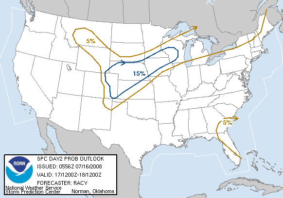
DAY 2 CONVECTIVE OUTLOOK
NWS STORM PREDICTION CENTER NORMAN OK
1215 AM CST THU FEB 09 2006
...SYNOPSIS...
AMPLIFIED LARGE-SCALE PATTERN WILL CONTINUE THROUGH THE DAY TWO
PERIOD AS A BROAD TROUGH IS ESTABLISHED OVER THE CNTRL U.S. AND
RIDGING CONTINUES FROM WRN CANADA SWD THROUGH THE GREAT BASIN.
MEANWHILE...CLOSED LOW NOW APPROACHING BAJA CA IS FORECAST TO SHEAR
OUT ACROSS NRN MEXICO AND SRN TX BEFORE BEING ENTRAINED INTO
INCREASINGLY CONFLUENT FLOW REGIME OVER THE GULF COAST.
IN THE LOW-LEVELS...STRONG COLD FRONT INITIALLY EXTENDING FROM LOW
PRESSURE OVER THE WRN GREAT LAKES INTO THE SRN HIGH PLAINS WILL
RAPIDLY PUSH SEWD THROUGH THE SRN PLAINS AND GULF COAST REGION. A
SECONDARY LOW PRESSURE AREA /ASSOCIATED WITH WEAKENING SRN STREAM
DISTURBANCE/ WILL DEVELOP ENEWD ALONG THIS COLD FRONT FROM CNTRL TX
INTO SRN OR CNTRL GA BY SATURDAY MORNING.
...SERN TX INTO THE CNTRL GULF COAST...
CURRENT SURFACE OBSERVATIONS INDICATE A RIDGE OF HIGH PRESSURE FROM
THE SABINE RIVER VALLEY SWD THROUGH THE WRN GULF BASIN WITH 60F
DEWPOINTS CONFINED TO THE SRN BAY OF CAMPECHE. WHILE LOW-LEVEL SLY
FLOW IS FORECAST TO INCREASE OVER THE NEXT 24-36 HRS...IT APPEARS
THAT ONLY A MODIFIED CP AIR MASS WILL RETURN NWD AHEAD OF COLD FRONT
WITH DEWPOINTS REMAINING LARGELY IN THE 50S.
CLUSTERS OF MAINLY ELEVATED TSTMS ARE EXPECTED TO BE IN PROGRESS AT
THE ONSET OF THE FORECAST FRIDAY MORNING OVER PORTIONS OF CNTRL TX
WITHIN STRENGTHENING LOW-LEVEL WAA REGIME ASSOCIATED WITH SRN STREAM
SHORTWAVE TROUGH MOVING EWD THROUGH SWRN TX. INCREASED LARGE-SCALE
FORCING FOR ASCENT AHEAD OF THIS FEATURE WILL SUPPORT ADDITIONAL
TSTM DEVELOPMENT OVER THE COURSE OF THE DAY ACROSS CNTRL/ERN TX WITH
STORMS BECOMING PROGRESSIVELY MORE SURFACE-BASED NEAR THE COAST.
A SEPARATE BELT OF 55-65 KT MID-LEVEL SWLY FLOW ASSOCIATED WITH THE
TX SHORTWAVE TROUGH WILL SPREAD EWD ACROSS THE TX COAST FRIDAY WITH
DEEP-LAYER SHEAR PROFILES BECOMING QUITE SUPPORTIVE OF
ORGANIZED/ROTATING UPDRAFTS. HOWEVER AS MENTIONED ABOVE...LOW-LEVEL
MOISTURE RETURN WILL BE PROBLEMATIC...AND WHEN COUPLED WITH MOIST
ADIABATIC LOW/MID-LEVEL LAPSE RATES...AIR MASS IS EXPECTED TO BECOME
ONLY WEAKLY UNSTABLE WITH SBCAPES AOB 500-700 J/KG.
SOME POTENTIAL WILL EXIST FOR A BRIEF TORNADO OR TWO WITH ANY
SURFACE-BASED STORMS DEVELOPING AHEAD OF SECONDARY SURFACE LOW FROM
THE SE TX COAST EWD ACROSS FAR SRN LA. OTHER STORMS DEVELOPING
ALONG SEWD-MOVING COLD FRONT WILL ALSO POSE AN ISOLATED DAMAGING
WIND THREAT. ONLY LOW SEVERE PROBABILITIES WILL BE INCLUDED ATTM
OWING TO THE ANTICIPATED WEAK INSTABILITY. SHOULD IT BECOME
APPARENT MORE INSTABILITY WILL DEVELOP THAN IS CURRENTLY
FORECAST...A SLIGHT RISK BE REQUIRED FOR PART OF THE REGION.
..MEAD.. 02/09/2006
0 likes
-
Extremeweatherguy
- Category 5
- Posts: 11095
- Joined: Mon Oct 10, 2005 8:13 pm
- Location: Florida
well the latest NWS forecast is cooler, but not cold yet. The interesting thing is that they have us in the middle 30s with precipitation on Friday night (which is getting on the edge there of wintry precip). Their latest forecast for saturday is in the lower 50s with a low in the upper 20s. Still a little too warm...but much better than yesterday's 56-30.
There is a much better (Houston) AFD too...here is a piece of it:
COLD FRONT SHOULD REACH NRN ZONES EARLY AFTN AND THE COAST BY 00Z
WITH PRECIP ENDING QUICKLY EARLY EVENING. ETA 2M TEMPS SUGGEST THAT
TEMPS COULD FALL 20 DEGREES WITHIN AN HOUR OR TWO OF THE FRONTAL
PASSAGE SO FORECAST WILL REFLECT FALLING TEMPS IN THE NRN HALF FRIDAY
AFTN. THINK WINDS WILL STAY UP ENOUGH FRIDAY NIGHT TO PREVENT FREEZING
TEMPS EXCEPT IN THE FAR NORTH. LATEST GFS/ECMWF STILL SHOW VERY LOW
850 MB TEMPS OVER CWA BY SATURDAY EVENING (-4 TO -8C)...SO FREEZING
TEMPS STILL LOOK LIKELY OVER MUCH OF THE AREA SATURDAY NIGHT. SUNDAY
NIGHT COULD STILL SEE A LIGHT FREEZE IN THE NE ZONES. LATEST MODEL
RUNS KEEP AIRMASS DRY THROUGH MIDDLE OF NEXT WEEK...WITH TEMPS WARMING
BACK TO NEAR NORMAL.
0 likes
-
Extremeweatherguy
- Category 5
- Posts: 11095
- Joined: Mon Oct 10, 2005 8:13 pm
- Location: Florida
Actually I am predicting 22-27 at IAH...20-22 is too cold. I said that Hooks and Conroe may get down to 20-22 though. really all depends on whether we see cloud cover, wind, etc. on Saturday night or whether we see perfect radiational cooling.Brent wrote:CajunMama wrote:Wow extreme...you make it sound like Dr. Neil doesn't know what he's talking about.
The strange thing is, if he was predicting 20 or 22 for IAH, he would totally agree with him.

Last edited by Extremeweatherguy on Thu Feb 09, 2006 7:43 am, edited 1 time in total.
0 likes

Strong arctic front to arrive late Friday with a widespread freeze likely Sunday morning.
Moisture will rapidly return to SE TX today and tonight setting the stage for rain and thunderstorms on Friday. Upper low currently over Baja will shear ENE into TX and weaken, but provide plenty of lift for thunderstorms Friday afternoon. Strong arctic boundary will blast southward with some of the coldest air of this winter arriving Friday. Temps. will fall 20-25 degrees with the frontal passage Friday afternoon and evening with strong north surface winds.
Moisture surges this evening as a 40kt low level jet develops and transports PWS of 1.1-1.4 inches into the area. Air mass will be primed for rain by early Friday and echoes should appear on the radar scope by 600am Friday morning. Surface warm sector may advance inland during the day Friday and a combination of the approaching arctic front, the upper low, and increasing surface instability may lead to a few severe thunderstorms during the afternoon.
Arctic boundary surges southward Friday evening entering the Gulf. Surface winds will howl Friday night with gust up to 40mph and maybe 50mph at the offshore platforms. Gale Warnings and Windy Advisories may be needed for Friday night and early Saturday. Such winds when combined with cold surface temps. will make for miserable wind chills (in the 20’s). Skies will stay cloudy Friday night and Saturday morning and with the strong winds temps. should only fall into the mid 30’s.
Skies clear midday Saturday as large arctic high settles into the state. Winds will decrease and go clam by early evening setting up excellent radiational cooling conditions. Widespread freezing temps. are likely Sunday morning with many areas outside the Beltway falling into the mid to upper 20’s.
SE TX Forecast:
Today: increasing clouds with highs in the mid 60’s.
Tonight: Becoming cloudy with a 30% chance of rain toward morning. Steady temperatures in the mid 50’s. Winds E at 10-15mph
Friday: cloudy with rain and thunderstorms likely. Chance of rain near 100%. Some storms could be severe with large hail being the main threat. Highs in the mid 60’s, then falling into the 40’s during the late afternoon. SE winds 15-20mph shifting to the NW and increasing 20-30mph and gusty during the late afternoon.
Friday night: cloudy and much colder with a 30% chance of showers early. Lows in the mid 30’s. North winds 25-35mph and gusty. Wind chills in the 20’s.
Saturday: clearing and cold. Highs in the upper 40’s to lower 50’s. N winds 15-25mph and gusty.
Saturday night: clear and very cold. Lows in the mid to upper 20’s outside the Beltway, and upper 20’s to lower 30’s inside the Beltway.
Sunday: sunny and cool. Highs in the low to mid 50’s.
0 likes
-
Extremeweatherguy
- Category 5
- Posts: 11095
- Joined: Mon Oct 10, 2005 8:13 pm
- Location: Florida
looking at his forecast this morning. I actually do like it. He now has Houston at 45 on Saturday and 48 on Sunday. I think his highs are excellent. As for the lows...he now has 26 for Sunday morning...which is within my area of thought for IAH...and would also mean that outlying areas like Hooks and Conroe would be in the 19-24F area.CajunMama wrote:Wow extreme...you make it sound like Dr. Neil doesn't know what he's talking about.
0 likes

After this weekend the flow goes back to zonal which means warmer temps at least in Florida, we have are 2 day winter this weekend.
EXTENDED FORECAST THROUGH MID WEEK NEXT WEEK...TEMPS GRADUALLY WARM
AGAIN AS PATTERN BECOMES MORE ZONAL. GFSLR IS SHOWING DECENT RETURN
MOISTURE BY THURSDAY OF NEXT WEEK. MAY SEE A FEW SHOWERS ALONG THE
EAST COAST BY THEN.
That's the Miami NWS dicussion.
EXTENDED FORECAST THROUGH MID WEEK NEXT WEEK...TEMPS GRADUALLY WARM
AGAIN AS PATTERN BECOMES MORE ZONAL. GFSLR IS SHOWING DECENT RETURN
MOISTURE BY THURSDAY OF NEXT WEEK. MAY SEE A FEW SHOWERS ALONG THE
EAST COAST BY THEN.
That's the Miami NWS dicussion.
0 likes
-
Tyler
jeff wrote:Strong arctic front to arrive late Friday with a widespread freeze likely Sunday morning.
Moisture will rapidly return to SE TX today and tonight setting the stage for rain and thunderstorms on Friday. Upper low currently over Baja will shear ENE into TX and weaken, but provide plenty of lift for thunderstorms Friday afternoon. Strong arctic boundary will blast southward with some of the coldest air of this winter arriving Friday. Temps. will fall 20-25 degrees with the frontal passage Friday afternoon and evening with strong north surface winds.
Moisture surges this evening as a 40kt low level jet develops and transports PWS of 1.1-1.4 inches into the area. Air mass will be primed for rain by early Friday and echoes should appear on the radar scope by 600am Friday morning. Surface warm sector may advance inland during the day Friday and a combination of the approaching arctic front, the upper low, and increasing surface instability may lead to a few severe thunderstorms during the afternoon.
Arctic boundary surges southward Friday evening entering the Gulf. Surface winds will howl Friday night with gust up to 40mph and maybe 50mph at the offshore platforms. Gale Warnings and Windy Advisories may be needed for Friday night and early Saturday. Such winds when combined with cold surface temps. will make for miserable wind chills (in the 20’s). Skies will stay cloudy Friday night and Saturday morning and with the strong winds temps. should only fall into the mid 30’s.
Skies clear midday Saturday as large arctic high settles into the state. Winds will decrease and go clam by early evening setting up excellent radiational cooling conditions. Widespread freezing temps. are likely Sunday morning with many areas outside the Beltway falling into the mid to upper 20’s.
SE TX Forecast:
Today: increasing clouds with highs in the mid 60’s.
Tonight: Becoming cloudy with a 30% chance of rain toward morning. Steady temperatures in the mid 50’s. Winds E at 10-15mph
Friday: cloudy with rain and thunderstorms likely. Chance of rain near 100%. Some storms could be severe with large hail being the main threat. Highs in the mid 60’s, then falling into the 40’s during the late afternoon. SE winds 15-20mph shifting to the NW and increasing 20-30mph and gusty during the late afternoon.
Friday night: cloudy and much colder with a 30% chance of showers early. Lows in the mid 30’s. North winds 25-35mph and gusty. Wind chills in the 20’s.
Saturday: clearing and cold. Highs in the upper 40’s to lower 50’s. N winds 15-25mph and gusty.
Saturday night: clear and very cold. Lows in the mid to upper 20’s outside the Beltway, and upper 20’s to lower 30’s inside the Beltway.
Sunday: sunny and cool. Highs in the low to mid 50’s.
Thanks for the discussion jeff. Wow, 20 degree drops in one hour. This front is going to be impressive!
0 likes
Who is online
Users browsing this forum: No registered users and 181 guests