The posts in this forum are NOT official forecast and should not be used as such. They are just the opinion of the poster and may or may not be backed by sound meteorological data. They are NOT endorsed by any professional institution or


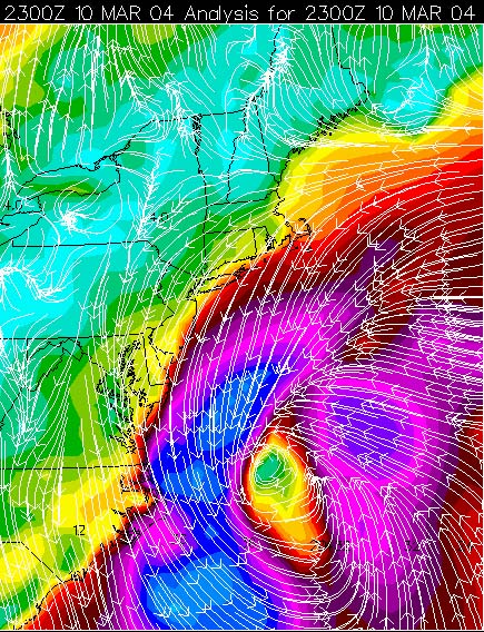
A STORM WILL CONTINUE TO INTENSIFY OFF THE MID ATLANTIC COAST
TONIGHT. THE LOW IS THEN EXPECTED TO INTENSIFY RAPIDLY
INTO A POWERFUL COASTAL STORM...AS IT CONTINUES TO LIFT
NORTHEAST...TO OFF NEW ENGLAND BY THURSDAY.
WINDS ALONG THE ATLANTIC BEACHES ARE GUSTING TO NEAR 45 MPH...WITH
SUSTAINED WINDS OVER THE COASTAL WATERS OF 50 TO 60 MPH. THESE
STRONG WINDS WILL LEAD TO HIGH SURF TONIGHT...WITH NEARSHORE WAVES
OF 8 TO 10 FT POSSIBLE...AND WAVES OVER THE COASTAL WATERS OF 12 TO
14 FT. THE POUNDING ACTION OF THE WAVES ALONG THE COAST WILL CAUSE
MINOR TO MODERATE BEACH EROSION ALONG THE MARYLAND...VIRGINIA...AND
NORTHEAST NORTH CAROLINA BEACHES.
IN ADDITION TIDAL DEPARTURES FROM 3.5 TO 4.5 FEET ABOVE NORMAL WILL RESULT IN WIDESPREAD MODERATE COASTAL FLOODING.