Yep folks we are in the midst of an early taste of spring here in N VA. Our highs are consistently topping out well above progs each day. WOW.....when nature decides to go springlike, we sure know it down here!!! Even snow on north-facing slopes is melting like you wouldn't believe.......Last night I took a 45-degree jebwalk at 8pm. It was peculiar not having any ice to walk on........even more peculiar not needing gloves or a hat on an early February jebwalk.
Last night we only dropped to a mild 37 degrees, and tomorrow more of the same is on tap. I think we might get into the low 60s here in the DCA region.
Winter my foot!!! Snow on Thursday my foot LOL..........If there is a storm, we will get RAIN on Thursday if anything LOL LOL!! WOW folks we are 5 to 7 degrees ABOVE Climo now LOL!!!! Any more dumb predictions for snow in DCA on Thursday huh lol?
Another thing I noticed......the cold front is east of us......WOW what kind of COLD FRONT brings N VA highs in the mid 50s to near 60 degrees in EARLY FEBRUARY?
Anymore silly forecasters out there gonna insist on SNOW on THURSDAY in N VA east of the MTS?
Get off the fo0king crack!!!! IT WILL NOT SNOW IN WOODBRIDGE THIS WEEK. It's too warm, even with low dewpoints..............and today's Td is 33 degrees.
-Jeb
54 degrees and rising, plenty of time to top out at 60....
Moderator: S2k Moderators
Forum rules
 The posts in this forum are NOT official forecast and should not be used as such. They are just the opinion of the poster and may or may not be backed by sound meteorological data. They are NOT endorsed by any professional institution or STORM2K.

The posts in this forum are NOT official forecast and should not be used as such. They are just the opinion of the poster and may or may not be backed by sound meteorological data. They are NOT endorsed by any professional institution or STORM2K.

-
Anonymous
That would be nice, but we are going to have some milder ground temps to overcome with that system. Feb can be cold here, but this February is nothing like last year's February. It is as though we are going directly into March 2003 weather in February 2004. Oh well............
Upstate NY is getting lots of Lake Effect Snow, it never ceases to amaze me how those folks are in deep winter when we are experiencing spring weather here in N VA. Wow.
I've said this before, but it's worth mentioning again: Every winter I learn a little more, and this winter I have learned, through much heartbreak and anguish, that January can indeed be very, very cold, but that does not mean that N VA will see a lot of snow like in 2003. Winters in N VA are perfectly capable of being very, very cold and yet delivering copious amounts of rain, while finding a way to not snow or just have flurries or a ton of ice. Just look at last week.
Then comes the warmup. It's 54 right now with steady SW winds bringing in more mild air. We stand a very real possibility of seeing upper 50s today, with lows in the low 40s tonight. Imagine a jebwalk in early Feb in N VA without a coat. I may well find out what that is like before long, the way things are going. Wow what a massive warmup. Even the ground is going to completely thaw out and that will drive temps UP, UP, UP!!!
This winter was hyped up a bit too much back in December. The NE will get a big storm in early March, it is well within Climo for them, but we will see a lot of rain on saturated ground with some moderate flooding. Then it will turn very, very warm here.
-Jeb
0 likes
-
Anonymous
-
Cheesy_Poofs
- Category 1

- Posts: 376
- Joined: Wed Nov 19, 2003 5:54 pm
- Contact:
BigEyedFish wrote:Jeb...you are right again
Please see winter on I-95 thread...
5 weeks and counting until it is over...
No major storms in sight...as I said a week ago
There is the potential for a big storm next week according to the GFS..I know it is the GFS and far out, but hey..something to look out for. I think it is silly to call winter over right now.
0 likes

BigEyedFish wrote:Jeb...you are right again
Please see winter on I-95 thread...
5 weeks and counting until it is over...
No major storms in sight...as I said a week ago
oh, you mean the winter is over for the i-95 corridor thread. please, if anything is comical its that. Don, FLguy and SF have been saying for some time now that this is just a breif pattern shift.
0 likes
-
Cheesy_Poofs
- Category 1
- Posts: 376
- Joined: Wed Nov 19, 2003 5:54 pm
- Contact:
-
Anonymous
I did not say winter was over.
Let's repeat that again, shall we?
I did not say winter was over.
What I am saying is this: The Central and Southern Mid Atlantic will not see any big snowstorms this winter. We will get cold again, and sure, we will see a few chilly rains, and I would not be surprised if Woodbridge got a few flurries and even an inch or two of slushy snow.
But this winter is no 2003 winter. I don't know analogs, but this winter is more like 1982 when we were cold but with very little snow.
It is a cold winter but the storms and the cold air timing is way way off. Thus it's a cold winter for the MA but not much snow.
Winter is far from over but we will not see much snow apart from the occasional flurry. It WILL be cold a few more times this winter, interspersed with major warming trends like this one we are in now.
-Jeb
0 likes
-
Cheesy_Poofs
- Category 1
- Posts: 376
- Joined: Wed Nov 19, 2003 5:54 pm
- Contact:
-
vasnowlover
- Tropical Wave

- Posts: 4
- Joined: Sun Jan 25, 2004 3:50 pm
- Location: falls church, va (just outside DC)
- Contact:
jeb-keep in mind that there were quite a few days of 40's and low to mid 50's in early february last year here in DC. (for example, feb 4th was 54 degrees last year at DCA) don't lose hope! just becuase it is in the 50's one or two days in february does not mean it will never get cold and snow again
0 likes
-
Stormsfury

- Category 5

- Posts: 10549
- Age: 53
- Joined: Wed Feb 05, 2003 6:27 pm
- Location: Summerville, SC
vasnowlover wrote:jeb-keep in mind that there were quite a few days of 40's and low to mid 50's in early february last year here in DC. (for example, feb 4th was 54 degrees last year at DCA) don't lose hope! just becuase it is in the 50's one or two days in february does not mean it will never get cold and snow again
bingo, and exactly vasnowlover (and welcome to Storm2k)
For the others ... remember how January started out this year ... Um, record highs for the first few days??? Then what happened? Got BRUTALLY COLD ...
And look what's reloading in Canada and POISED ... with PNA ridging... oh, that looks like another shot of arctic air ... um, do I see -44.6ºC temperatures at 850mb on the move Southward? ...

0 likes
-
Anonymous
Yes, it got BRUTALLY COLD in the NORTHEAST.
NOT in the Mid Atlantic. THAT arctic air, cold as it is..................will do nothing more for the Mid Atlantic than strike a glancing blow. That translates into mostly RAIN with this storm in late Feb/early March.
I am living in the WRONG place..............................
-Jeb
NOT in the Mid Atlantic. THAT arctic air, cold as it is..................will do nothing more for the Mid Atlantic than strike a glancing blow. That translates into mostly RAIN with this storm in late Feb/early March.
I am living in the WRONG place..............................
-Jeb
0 likes
-
FLguy

- Professional-Met

- Posts: 799
- Joined: Mon Dec 29, 2003 5:36 pm
- Location: Daytona Beach FL
- Contact:

above is the northern hemispheric 500mb height analysis for 12z this afteroon.
notice the strong low near the Aleutian islands, and the positive tilted, closed trough (and closed low) across the southwest. the low near the aleutians pumps heat northward and results in building heights and strong ridging, whole the positive tilted trough forces height rises behind it. the resulant effect of this is the development of a deep downstream trough across the eastern part of the county. eventually, the PV should become re-established near hudsons bay and the re-development of the cold pattern across the eastern part of the country gets underway.
below is the normal northern hemispheric 500mb height set-up corresponding to the positive phase of the PNA:
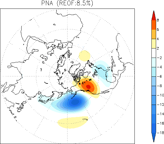
and the PNA forecast from the GFS ensembles:

0 likes
-
Anonymous
AS ALL OF YOU CAN SEE...........................
I know all too well about something that Don, FLguy, KOW and SF will never tell you...............and that because of my inadequate knowledge............not to mention the fact that I don't even begin to know where all that information is on the 'Net.............................I can not explain to you........................................
But this Arctic Blast will be THE WORST that has EVER slammed the Northeast in YEARS........................But will not affect the Mid Atlantic all that much. This arctic blast that is going to Humble the cold-jaded Northeast, will in fact be somewhat milder in the Mid Atlantic than what the MA experienced in January.
The Northeast had better watch out. This is going to be a life-threatening arctic blast, and the NE will be literally BURIED in excessive snow Feb into March. The LES machine will be stuck in the "ON" position again and more ridiculous snows will fall in Fulton and other places in favored LES locations.
But the Mid Atlantic into the Southeast.................Will be spared the worst of the arctic blast. The coldest DCA will see in the daytime will be 25 degrees if that. More likely 32 for HIGHS. Remember the Climo for N VA east of the mts as well as no snow cover east of the mts., longer days, milder average temps, thawed ground, and normal highs near 50 as we get into the middle of February.
Remember that the Mid Atlantic saw nowhere near the kinds of bone-chilling cold that the upper Northeast saw with the last arctic blast. That scenario will hold true now as it did back in January. We'll get cool in DCA but it won't even be as bad as in January. The NE though will freeze to death and will be shown NO mercy whatsoever. It may be record-breaking cold there.
But the most horrible truth of all is not just that the Mid Atlantic will get mostly RAIN, but that the SE and MA are destined to see immense flooding this spring....................while the NE gets buried in snow Feb thru April. It is all part of the unfolding pattern.
Most folks can not understand because most of us simply do not have enough time to try and understand the MJO, the QBO, and a lot of other jargon that you would need to understand to get the gist of what indeed is about to happen in the East over the next2 to 6 months.
But I am going to bust this farce right now. Seems like I have a gift for breaking through BS with VERY direct talk and believe me I am doing it right now!
This month we are going to see so much rain and in March too, that we will be facing floods you would not believe this spring in the MA and SE. The NE is going to be buried in snow. It will be rain south of MD though. This will be due to the fact that this upcoming arctic blast is going to be very very severe for the Northeast. It may be even colder than in January for folks in Maine, Vermont, places like that.
But it will be much, much less severe in the Mid Atlantic, as has been the case this winter, and will result in a snow to rain scenario over DCA and points south and west. That is why this winter's big storm will be a washout for the MA south, but potentially a major disaster for the Northeast. We're talking FEET of snow in the Northeast. That is just the way it is folks.
I do not pretend to understand the MJO, the QBO, and many other things in the Pacific, but what they all mean THIS WINTER is that the Mid Atlantic will get off very easy this winter. We will NOT get the worst the cold air has to offer, indeed, this blast, while very, very gravely frigid in the Northeast, will be much milder in the Mid Atlantic. The storm will develop in mid or late February but will mostly impact the Northeast. The MA will start off as snow but go to rain. That is the pattern of this winter and it is not about to change. All the rain the poor SE and waterlogged MA has already endured...................will go on and it will be one of the very worst wet springs the East has ever heard of. Nothing can be done about it. If the models are correct, the MA is about to turn cooler, but probably milder than January, then an overrunning event will set up. The snow will start then change to rain and we will measure that rain in INCHES folks here in the MA. Look at the SE right now!!! They will be getting rain up the ***. That trend will continue right thru spring. What will be snow changing to rain for the Mid Atlantic will be all snow for the NE and LOTS of it!!! Northeastern residents will be groaning under all the snow. They will be tired of it but it will keep coming in March even as the MA and SE gets rain, rain and more rain right into April.
It has been days since the rain we last endured and water is still bubbling out from under the pavement here in N VA. Well we are going to get still more rain and soon. The ground is saturated. The term, "Flooding", will be re-defined in the east and southeast this spring. The ground is already saturated. I guess I prayed for too much rain back in 2002. Boy are we ever paying for that now in the East and Southeast and South.
So get ready for brain-numbing cold in the NE and feet of snow. Get ready for a non-stop LES machine stuck in the "ON" position in the GL. Get ready Northeast for snow after snow after snow after snow, especially after the MA begins to warm up later in February or early-to-mid March. Then you folks will see no respite from snows in the Northeast.
Get ready for a cool-down in the Mid Atlantic, perhaps to highs in the 30s and lows in the high 20s. A storm will develop in mid or late month, may be overrunning or a Nor'easter type storm but it will happen then look for some snow that quickly changes to rain south of MD and piles up several inches of rainfall like the last storm we got but with no ice this time (too mild at the surface). We will see flooding because of the 2 inches we got last week, this next storm will add insult to injury in the MA and SE. Then there will be a few days of cool weather then a warm-up and storm after storm with rain on top of rain, especially in the South and Southeast states where flooding will be dominating headlines.
-Jeb
0 likes
I would love to see Jeb proven wrong, but the odds say he is probably right. Here in Alexandria, there is no more snow in my yard, and the Daffidills are 3 inches high, right on schedule for a Mar 15 blooming.
we will see cold weather again, of that Im sure. I dont think the Potomac will freeze again{Maybe near the shore }like it did in january{Totally iced over}
Any snow that falls will be the kind that will melt off by noon the next day.Not too far north they will have a deep snow{Abe and to the North}
Just my humble opinion, sure it was 54 Feb 4 2003 and we had a big snow feb 16, that was like hitting a lottery.
0 likes
-
FLguy
- Professional-Met
- Posts: 799
- Joined: Mon Dec 29, 2003 5:36 pm
- Location: Daytona Beach FL
- Contact:
paulvogel wrote:I would love to see Jeb proven wrong, but the odds say he is probably right. Here in Alexandria, there is no more snow in my yard, and the Daffidills are 3 inches high, right on schedule for a Mar 15 blooming.
we will see cold weather again, of that Im sure. I dont think the Potomac will freeze again{Maybe near the shore }like it did in january{Totally iced over}
Any snow that falls will be the kind that will melt off by noon the next day.Not too far north they will have a deep snow{Abe and to the North}
Just my humble opinion, sure it was 54 Feb 4 2003 and we had a big snow feb 16, that was like hitting a lottery.
climo is strongly against jeb
0 likes
-
ninmaven

- Tropical Low

- Posts: 20
- Age: 64
- Joined: Fri Sep 26, 2003 9:14 am
- Location: North Plainfield, NJ (NE Somerset County)
- Contact:
Jeb wrote:But this Arctic Blast will be THE WORST that has EVER slammed the Northeast in YEARS........................But will not affect the Mid Atlantic all that much. This arctic blast that is going to Humble the cold-jaded Northeast, will in fact be somewhat milder in the Mid Atlantic than what the MA experienced in January.
The Northeast had better watch out. This is going to be a life-threatening arctic blast, and the NE will be literally BURIED in excessive snow Feb into March. The LES machine will be stuck in the "ON" position again and more ridiculous snows will fall in Fulton and other places in favored LES locations.
-Jeb
Jeb, you are pessimistic for your area and optimistic for the North East, but based on the local forecasts for the NYC metro area that I've seen, your ideas are quite exaggerated. Maybe some of your ideas are more on target for parts of New England and in LES areas, but not for my area, which is definitely part of the North East and, therefore, in the area for which you are predicting.
Now, I don't know how to read models or anything, I'm just going by what some local and non-local Mets have said over the past couple of days, but this is the general idea of what I've seen in the forecasts -- for the NYC metro area, the upcoming arctic cold will NOT be the worst in years. Temps on Sat. night should be in the low- to mid-teens, Sun. should be in the low 20s for a high, dropping to mid-single digits on Sun. night, and then Monday upper 20s for a high and upper teens at night. After that, the temps will be seasonable. So it looks like this arctic outbreak will last 3 days max, and it won't even get as cold as it did in January.
As for being buried in snow until April - maybe some of the LES areas will still get a lot of snow, but unless we get a storm as bad as the 2003 President's Day storm within the next couple of weeks and then temps stay relatively cold, any snow we get will melt within a couple of weeks max. Yes, it did take a little over a month for all the snow from Feb 2003 to melt (this also included a few more inches that fell a week later), but there was just so much snow! And I doubt we'll get that much in the next couple of weeks. If we do get a huge storm in early March, the snow will not stick around very long because temps will be warming up.
So please don't paint such a drastic picture of winter weather for the NE for the remainder of this winter. Some areas will be colder and snowier than others, and other areas like mine will still see some storms through March, but there won't be a constant snowpack until April. And, to end this, I'm not pessimistic for your area at all. I think you'll see some snow before the season is over so don't give up hope!
0 likes
-
ninmaven
- Tropical Low
- Posts: 20
- Age: 64
- Joined: Fri Sep 26, 2003 9:14 am
- Location: North Plainfield, NJ (NE Somerset County)
- Contact:
P.S. To be fair Jeb, I read some of your posts in other threads, and you do say you think the worst of the cold will be in places like Maine and VT. It's definitely going to be very cold and hopefully snowy here though, although I doubt it will be record breaking. I do hope that everyone (including myself) who is hoping for at least one more big snow this season gets it.  And then it's on to spring storms and hurricane season!
0 likes
Who is online
Users browsing this forum: No registered users and 177 guests