The posts in this forum are NOT official forecast and should not be used as such. They are just the opinion of the poster and may or may not be backed by sound meteorological data. They are NOT endorsed by any professional institution or

1. The warmth in the January 12-15 timeframe will not rival that of the January 5-6.
2. The January 8-15 period was likely to be warm before a gradual pattern change set in.
3. During the January 8-15 timeframe, I noted on December 27 for the Washington, DC to Boston region that " One or more days with a high temperature of 60° is possible throughout the region."
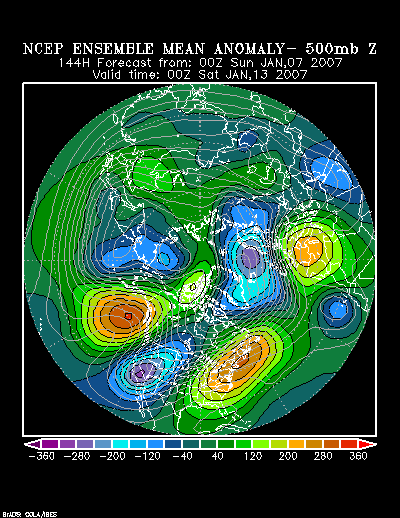
The warmest part of the January 8-15 period appears likely to occur in the closing 4 days of that timeframe. The latest forecast of the NCEP ensemble mean 500 mb anomalies is consistent with a pattern that has produced warmth of the magnitude noted above.
1/7 0z NCEP Ensemble Mean 500 mb Anomalies forecast for 144 hours:
That pattern is consistent with several warm ones that occurred in the January 5-20 timeframe since 1950.
Northern Hemisphere Composite 500 mb Anomalies:[b/]

[b]North American 500 mb Composite Anomalies:

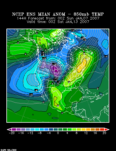
The NCEP Ensemble forecast for 850 mb Temperature Anomalies at 144 hours follows:
During those periods for which the above height anomalies were present, the highest temperature reached in select cities was:
January 14-18, 1952:
Atlanta: 70°
Boston: 53°
Burlington: 45°
New York City: 54°
Philadelphia: 58°
Richmond: 75°
Washington, DC: 74°
January 16-18, 1990:
Atlanta: 71°
Boston: 63°
Burlington: 52°
New York City: 66°
Philadelphia: 64°
Richmond: 72°
Washington, DC: 69°
January 12-14, 2005:
Atlanta: 68°
Boston: 63°
Burlington: 58°
New York City: 66°
Philadelphia: 66°
Richmond: 75°
Washington, DC: 71°
At this time, that kind of warmth should be seen as offering some insight into the potential magnitude of the 1/12-15 warm period at its warmest: 45° or better in Burlington, 50s in the northern Mid-Atlantic and southern New England, and 60° or above in the remainder of the Mid-Atlantic region, including Philadelphia. One day topping out at 50° in Burlington and 60° in New York City and Boston is a possibility. Atlanta should top out in the 60s.