 The posts in this forum are NOT official forecast and should not be used as such. They are just the opinion of the poster and may or may not be backed by sound meteorological data. They are NOT endorsed by any professional institution or

Then, the NCEP ensemble mean 500 mb anomalies for 12/25 0z were:

The latest NCEP ensemble mean 500 mb anomalies for 12/26 0z are:

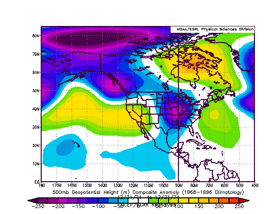
The 500 mb anomalies for 12/21/1974 were:
The 12/18-21/1974 period saw the following snowfall totals for select cities.
Chicago: 4.1"
Des Moines: 3.8"
Detroit: 6.4"
Indianapolis: 2.6"
Milwaukee: 7.5"
Windsor: 6.5" (16.5 cm)
At last word, the major features are somewhat farther to the south and east on the ensemble mean than they were on 12/12. Considering also the 12z ECMWF and GFS and the 18z GFS, I believe the highest potential for accumulating snow will involve an area across parts of Indiana, eastern Michigan, western Ohio, and parts of Ontario (including Windsor and London). In this area, I believe some locations could see several inches of snow (initially, 2"-4" seems reasonable with a few spots picking up a little more).
Eastern Ohio, western Pennsylvania, and southern Ontario, including snow-starved Toronto, should see at least a little snow as the storm heads away. There is a chance that Toronto could pick up several centimeters of snow.


