DISCLAIMER: The following post is NOT an official forecast and should not be used as such. It is just the opinion of the poster and may or may not be backed by sound meteorological data. It is NOT endorsed by any professional institution including storm2k.org. For Official Information please refer to the NHC and NWS products.
First off, let me just say that at this point I do not have a map I can use, but I do intend to find one relatively soon and at that point I'll put up a graphical representation. For now, let's just cut to the chase.
As the low currently headed through the Ohio Valley passes, there's cold air coming down the backside. Right now, it's in the low 40's with rain in Cincinnati (official reporting station in N KY), but still mid 40's at Lunken Field in Cincy proper, and 33 in Evansville, Indiana where they have snow falling right now.
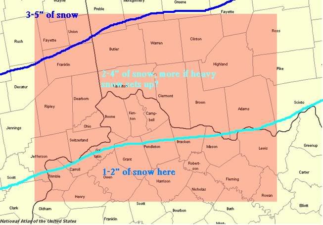
So, the cold air spills down and the rain currently in the Cincy area will switch to snow. A heavy snow band may set up which does have me worried. Right now, my call is as follows for Ohio, Indiana, and Kentucky:
In cities such as Louisville, Lexington, and Frankfort, KY, along with areas between these cities and Cincinnati, I expect 1-2".
Just north of that, the metro area of Cincinnati should see 2-4" with that heavy snow band setting up near there.
And for points north and east of that, I expect 3-5", again that heavy snow band may come into play.
Either way, Cincinnati looks to take a hit from a good snow maker. It all depends on that heavy snow band setting up, whether it does or not and, if it does, where.
Ohio Valley snow - Accumulation forecast
Moderator: S2k Moderators
Forum rules
 The posts in this forum are NOT official forecast and should not be used as such. They are just the opinion of the poster and may or may not be backed by sound meteorological data. They are NOT endorsed by any professional institution or STORM2K.

The posts in this forum are NOT official forecast and should not be used as such. They are just the opinion of the poster and may or may not be backed by sound meteorological data. They are NOT endorsed by any professional institution or STORM2K.
-
therock1811

- Category 5

- Posts: 5163
- Age: 40
- Joined: Thu May 15, 2003 2:15 pm
- Location: Kentucky
- Contact:
-
therock1811
- Category 5
- Posts: 5163
- Age: 40
- Joined: Thu May 15, 2003 2:15 pm
- Location: Kentucky
- Contact:
-
Gord_on_snow
- Tropical Storm

- Posts: 100
- Joined: Sun Jan 25, 2004 9:34 am
- Location: Columbus, OH


Who is online
Users browsing this forum: Brent and 48 guests