Early start to the Cape Verde season?

This is the general tropical discussion area. Anyone can take their shot at predicting a storms path.

Moderator: S2k Moderators

Forum rules

The posts in this forum are NOT official forecasts and should not be used as such. They are just the opinion of the poster and may or may not be backed by sound meteorological data. They are NOT endorsed by any professional institution or STORM2K. For official information, please refer to products from the National Hurricane Center and National Weather Service.

Help Support Storm2K
Message
Author
User avatar
Windspeed
Tropical Storm
Tropical Storm
Posts: 129
Joined: Thu Jun 10, 2004 11:38 am

Early start to the Cape Verde season?

#1 Postby Windspeed » Sat Jun 04, 2005 8:27 am

There is a very established wave exiting the continent of Africa at 1200 UTC. There even appears to be a decent mid-level rotation in the wave's axis. Though it is not unusual to have a strong wave exit this early in June, it is unusual how high in lattitude the 26ºC isotherm is in the eastern Atlantic for this time of year. If strong waves like this keep rolling off the west coast of Africa, fears of an early start to the 2005 Cape Verde season may be realized:

Image
0 likes   

Anonymous

#2 Postby Anonymous » Sat Jun 04, 2005 8:41 am

Matt, you and I talked about this a few days ago. Remember the depression that formed from a Cape Verde wave in June 2003? It may indeed occur. I'm waiting to see if Dr. Lyons mentions it on the tropical update.
0 likes   

User avatar
dhweather
S2K Supporter
S2K Supporter
Posts: 6199
Joined: Sat Aug 14, 2004 9:29 pm
Location: Heath, TX
Contact:

#3 Postby dhweather » Sat Jun 04, 2005 8:49 am

That's a healthy wave coming off the coast.
0 likes   

User avatar
TampaFl
S2K Supporter
S2K Supporter
Posts: 1904
Age: 67
Joined: Thu Sep 04, 2003 11:23 am
Location: Tampa, FL

#4 Postby TampaFl » Sat Jun 04, 2005 8:50 am

:eek: :eek: :eek:
0 likes   

Josephine96

#5 Postby Josephine96 » Sat Jun 04, 2005 8:53 am

Look at all the deep reds in it.. Looks like it could become very healthy if it holds together..

I also think we are all very antsy lol
0 likes   

Brent
S2K Supporter
S2K Supporter
Posts: 38117
Age: 37
Joined: Sun May 16, 2004 10:30 pm
Location: Tulsa Oklahoma
Contact:

#6 Postby Brent » Sat Jun 04, 2005 9:00 am

Geez...
0 likes   
#neversummer

Javlin
Category 5
Category 5
Posts: 1621
Age: 64
Joined: Fri Jul 09, 2004 7:58 pm
Location: ms gulf coast

#7 Postby Javlin » Sat Jun 04, 2005 9:15 am

Not quite yet I think guys.You have one ULL moving out to the NE and another approaching from the W.Then it is a little moisture out there as opposed to a couple of weeks ago just don't know if enough.
http://www.ssd.noaa.gov/PS/TROP/DATA/RT ... -loop.html

Off topic to this 10' rule in relation to tropical systems I need a memory refreshner Derek.
0 likes   

Scorpion

#8 Postby Scorpion » Sat Jun 04, 2005 9:44 am

It'll go poof in the next few hours with the shear and all. :grr:
0 likes   

krysof

#9 Postby krysof » Sat Jun 04, 2005 9:54 am

What you guys say about the wave if it was August?
0 likes   

Derek Ortt

#10 Postby Derek Ortt » Sat Jun 04, 2005 10:42 am

there's no 10 degree rule. You can get development bascially on the equator if there is enough environmental vorticity.

For the Atlantic, the monsoon trough off of Africa is usually near 8N at this time of year. Any CV June development will likely be between 8-11N
0 likes   

User avatar
HURAKAN
Professional-Met
Professional-Met
Posts: 46086
Age: 38
Joined: Thu May 20, 2004 4:34 pm
Location: Key West, FL
Contact:

#11 Postby HURAKAN » Sat Jun 04, 2005 10:52 am

Image

ANA IS A GOOD EXAMPLE OF WHERE STORM USUALLY FORM IN THE CENTRAL ATLANTIC THIS EARLY IN THE SEASON, BY THE WAY, IT'S VERY UNUSUAL TO SEE A TROPICAL STORM THIS EARLY IN THE CENTRAL ATLANTIC.
0 likes   

hurricanefreak1988
Category 3
Category 3
Posts: 869
Joined: Thu Jul 22, 2004 10:13 pm
Location: Fayetteville, NC
Contact:

#12 Postby hurricanefreak1988 » Sat Jun 04, 2005 12:31 pm

A Cape Verde storm being the season opener? Who woulda thought? That'll be interesting if it does indeed form.
0 likes   

cyclonaut

#13 Postby cyclonaut » Sat Jun 04, 2005 12:56 pm

I think a system east of the islands will be the 1st one of the year.
0 likes   

User avatar
gatorcane
S2K Supporter
S2K Supporter
Posts: 23693
Age: 47
Joined: Sun Mar 13, 2005 3:54 pm
Location: Boca Raton, FL

#14 Postby gatorcane » Sat Jun 04, 2005 1:39 pm

Looks very healthy but it will most likely fizzle out once it exits the coast completely....if it were August this would be another story
0 likes   

User avatar
Windspeed
Tropical Storm
Tropical Storm
Posts: 129
Joined: Thu Jun 10, 2004 11:38 am

#15 Postby Windspeed » Sat Jun 04, 2005 2:18 pm

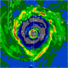
Keep in mind, I was not trying to imply that this particular wave will develop into anything signficant in the context of my original post. Only that I have concerns the Atlantic Basin will experience Cape Verde storms earlier than the average year based on the fact the monsoon trough off of Africa is currently producing strong tropical waves (such as the one at present) and the 26ºC isotherm is at a higher lattitude near the Cape Verde Islands than what is typically observed this early in <b>June</b>. Obviously, the SAL might be a player in this too. A moderate-to-strong SAL could keep early Cape Verde activity in check. Though at present, the SAL seems to be extending east-to-west north of the MDR right now. Therefore, as of right now I would not be surprised if we observe cyclogenesis somewhere SE, S, or SW of the Cape Verdes during the next 3-6 weeks. Even the development of <b>2 or 3 storms before August 1st</b> in the MDR east of the Lesser Antilles would not shock me with the present oceanic heat content that is already there. See the image below:


Image
0 likes   

Matt-hurricanewatcher

#16 Postby Matt-hurricanewatcher » Sat Jun 04, 2005 2:35 pm

Holy mother of god that is a nice looking wave. With banding futures to the southern Quad. Darn if that holds together wow.
0 likes   

storm4u
Category 2
Category 2
Posts: 651
Joined: Wed Aug 11, 2004 7:26 am
Location: agawam, ma
Contact:

#17 Postby storm4u » Sat Jun 04, 2005 2:47 pm

If it was 3 months later there would be a big smile on my face!! But its not so there not!!lol The time will come people!!
0 likes   

Anonymous

#18 Postby Anonymous » Sat Jun 04, 2005 2:50 pm

If they do form, and become Hurricanes east of the islands, we could even have a long tracked Cape Verde Hurricane in July.
0 likes   

User avatar
cycloneye
Admin
Admin
Posts: 146196
Age: 69
Joined: Thu Oct 10, 2002 10:54 am
Location: San Juan, Puerto Rico

#19 Postby cycloneye » Sat Jun 04, 2005 2:54 pm

~Floydbuster wrote:If they do form, and become Hurricanes east of the islands, we could even have a long tracked Cape Verde Hurricane in July.


Image

Early July longtracker hurricane Bertha in 1996.
0 likes   

User avatar
James
Category 5
Category 5
Posts: 1531
Joined: Tue Aug 24, 2004 10:29 am
Location: Gloucestershire, England
Contact:

#20 Postby James » Sat Jun 04, 2005 3:31 pm

It has faded a bit, but still has an impressive structure. I can't believe it's been a year since we were doing this last June.
0 likes   


Return to “Talkin' Tropics”

Who is online

Users browsing this forum: Google Adsense [Bot], IcyTundra, Shawee and 44 guests