

Moderator: S2k Moderators


Ntxw wrote:Speaks for itself. Might be the coolest summer since 2014.
https://images2.imgbox.com/d6/ba/hpt4rG7H_o.gif
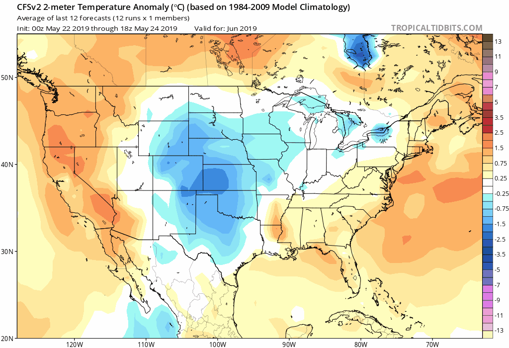
CFSv2- All of this rain the plains has been getting means wet soils. Keeping any heat waves at bay. Revenge of Winter.
https://images2.imgbox.com/e2/71/FgTFW43q_o.gif

Rgv20 wrote:Hopefully no repeat of this Heat Indices! Enjoy the Summer temperatures my fellow Texas members!
http://i68.tinypic.com/2qapdlx.png
ThunderSleetDreams wrote:Rgv20 wrote:Hopefully no repeat of this Heat Indices! Enjoy the Summer temperatures my fellow Texas members!
http://i68.tinypic.com/2qapdlx.png
You couldn’t pay me a crapload of money to live where you do. NOT. A. CHANCE. IN. HELL!


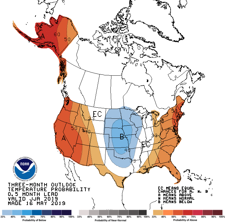
Ntxw wrote:daily SOI is well into negative territory. It has been so since about the last week of the month. Expect early June to be disturbed by rainfall. No sign yet of a significant heat dome.
South Texas Storms wrote:Ntxw wrote:daily SOI is well into negative territory. It has been so since about the last week of the month. Expect early June to be disturbed by rainfall. No sign yet of a significant heat dome.
Yeah next week is looking pretty wet. A surge of tropical moisture, currently the area of disturbed weather across Central America, will be pushing northward across the western Gulf. This is then forecast to interact with the next slow-moving southern stream disturbance helping to bring us several days of enhanced rain chances. Bring it on...the longer we can go without any major heat, the better off we'll be!


Ntxw wrote:The US (especially the middle of the country) has very wet soil content right now. It's going to be hard large scale to really get any heat waves going nationally. Even the desert southwest is not all that hot. The signs are there this should be a uniquely cool summer due to feedback effects. Summer, unlike winter, is a much easier thing to forecast trend wise. It comes down to simply two things, does it rain and is there feedback?
Phoenix, a good indicator of the Sonoran Ridge strength, for May is running -6F below normal!

gpsnowman wrote:Happy summer Storm2kers. It is here, the worst season of all but also one of the most fun. Vacations, baseball, kids out of school, and most importantly, no school zones. Only a few more weeks and the days will be shorter until winter. Hang in there folks.
gpsnowman wrote:The cell in Parker County looks like it could sweep through some of the metro soon.
Return to “USA & Caribbean Weather”
Users browsing this forum: No registered users and 61 guests

