WPAC: TEMBIN - Post-Tropical
Moderator: S2k Moderators
-
mrbagyo

- Category 5

- Posts: 3617
- Age: 32
- Joined: Thu Apr 12, 2012 9:18 am
- Location: 14.13N 120.98E
- Contact:
Re: WPAC: TEMBIN - (JMA) Severe Tropical Storm - (JTWC) Typhoon
0 likes
The posts in this forum are NOT official forecast and should not be used as such. They are just the opinion of the poster and may or may not be backed by sound meteorological data. They are NOT endorsed by any professional institution or storm2k.org. For official information, please refer to RSMC, NHC and NWS products.
-
Digital-TC-Chaser
Re: WPAC: TEMBIN - (JMA) Severe Tropical Storm - (JTWC) Typhoon
http://rammb.cira.colostate.edu/visit/v ... layer.html
Quite long but worth it.
Quite long but worth it.
0 likes

Re: WPAC: TEMBIN - (JMA) Severe Tropical Storm - (JTWC) Typhoon
33W TEMBIN 171224 0000 8.2N 114.3E WPAC 75 980
0 likes
Remember, all of my post aren't official. For official warnings and discussions, Please refer to your local NWS products...
NWS for the Western Pacific
https://www.weather.gov/gum/
NWS for the Western Pacific
https://www.weather.gov/gum/


-
mrbagyo
- Category 5
- Posts: 3617
- Age: 32
- Joined: Thu Apr 12, 2012 9:18 am
- Location: 14.13N 120.98E
- Contact:
Re: WPAC: TEMBIN - (JMA) Severe Tropical Storm - (JTWC) Typhoon

0 likes
The posts in this forum are NOT official forecast and should not be used as such. They are just the opinion of the poster and may or may not be backed by sound meteorological data. They are NOT endorsed by any professional institution or storm2k.org. For official information, please refer to RSMC, NHC and NWS products.
-
Digital-TC-Chaser
Re: WPAC: TEMBIN - (JMA) Severe Tropical Storm - (JTWC) Typhoon
FKPQ31 RJTD 240000
TC ADVISORY
DTG: 20171224/0000Z
TCAC: TOKYO
TC: TEMBIN
NR: 15
PSN: N0835 E11440
MOV: WNW 14KT
C: 980HPA
MAX WIND: 65KT
FCST PSN +6HR: 24/0600Z N0835 E11320
FCST MAX WIND +6HR: 70KT
FCST PSN +12HR: 24/1200Z N0820 E11200
FCST MAX WIND +12HR: 70KT
FCST PSN +18HR: 24/1800Z N0820 E11040
FCST MAX WIND +18HR: 65KT
FCST PSN +24HR: 25/0000Z N0825 E10920
FCST MAX WIND +24HR: 60KT
RMK: NIL
NXT MSG: 20171224/0600Z =
Should be listed as typhoon on the title.
0 likes
-
1900hurricane

- Category 5
- Posts: 6044
- Age: 33
- Joined: Fri Feb 06, 2015 12:04 pm
- Location: Houston, TX
- Contact:
Re: WPAC: Typhoon Tembin
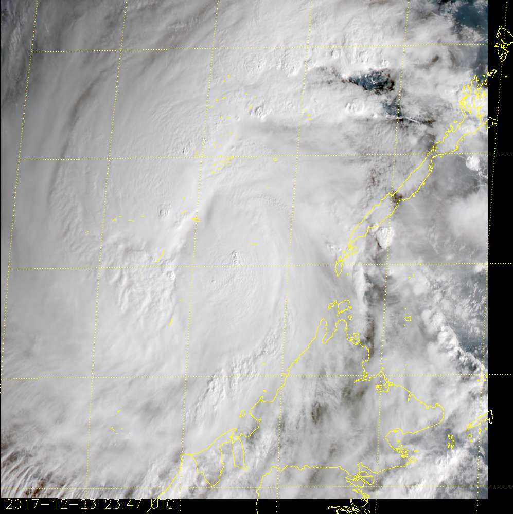
A nascent eye is appearing on visible imagery.

0 likes
Contract Meteorologist. TAMU & MSST. Fiercely authentic, one of a kind. We are all given free will, so choose a life meant to be lived. We are the Masters of our own Stories.
Opinions expressed are mine alone.
Follow me on Twitter at @1900hurricane : Read blogs at https://1900hurricane.wordpress.com/
Opinions expressed are mine alone.
Follow me on Twitter at @1900hurricane : Read blogs at https://1900hurricane.wordpress.com/
-
1900hurricane
- Category 5
- Posts: 6044
- Age: 33
- Joined: Fri Feb 06, 2015 12:04 pm
- Location: Houston, TX
- Contact:
Re: WPAC: Typhoon Tembin
Yeah, looks like JMA just upgraded at 00Z.

TY 1727 (Tembin)
Issued at 00:45 UTC, 24 December 2017
<Analysis at 00 UTC, 24 December>
Scale -
Intensity Strong
Center position N8°35' (8.6°)
E114°40' (114.7°)
Direction and speed of movement WNW 25 km/h (14 kt)
Central pressure 980 hPa
Maximum wind speed near center 35 m/s (65 kt)
Maximum wind gust speed 50 m/s (95 kt)
≥ 50 kt wind area ALL 60 km (30 NM)
≥ 30 kt wind area N 370 km (200 NM)
S 220 km (120 NM)
<Forecast for 12 UTC, 24 December>
Intensity Strong
Center position of probability circle N8°20' (8.3°)
E112°00' (112.0°)
Direction and speed of movement W 25 km/h (13 kt)
Central pressure 975 hPa
Maximum wind speed near center 35 m/s (70 kt)
Maximum wind gust speed 50 m/s (100 kt)
Radius of probability circle 70 km (40 NM)
Storm warning area ALL 170 km (90 NM)
<Forecast for 00 UTC, 25 December>
Intensity -
Center position of probability circle N8°25' (8.4°)
E109°20' (109.3°)
Direction and speed of movement W 25 km/h (13 kt)
Central pressure 985 hPa
Maximum wind speed near center 30 m/s (60 kt)
Maximum wind gust speed 45 m/s (85 kt)
Radius of probability circle 110 km (60 NM)
Storm warning area ALL 190 km (100 NM)
<Forecast for 00 UTC, 26 December>
Intensity -
Center position of probability circle N9°00' (9.0°)
E104°25' (104.4°)
Direction and speed of movement W 20 km/h (12 kt)
Central pressure 992 hPa
Maximum wind speed near center 23 m/s (45 kt)
Maximum wind gust speed 35 m/s (65 kt)
Radius of probability circle 200 km (110 NM)
<Forecast for 00 UTC, 27 December>
Intensity -
TD
Center position of probability circle N9°50' (9.8°)
E100°25' (100.4°)
Direction and speed of movement W 20 km/h (10 kt)
Central pressure 1004 hPa
Radius of probability circle 240 km (130 NM)
0 likes
Contract Meteorologist. TAMU & MSST. Fiercely authentic, one of a kind. We are all given free will, so choose a life meant to be lived. We are the Masters of our own Stories.
Opinions expressed are mine alone.
Follow me on Twitter at @1900hurricane : Read blogs at https://1900hurricane.wordpress.com/
Opinions expressed are mine alone.
Follow me on Twitter at @1900hurricane : Read blogs at https://1900hurricane.wordpress.com/
-
1900hurricane
- Category 5
- Posts: 6044
- Age: 33
- Joined: Fri Feb 06, 2015 12:04 pm
- Location: Houston, TX
- Contact:
Re: WPAC: Typhoon Tembin
Here's what I have for ACE and PDI so far:
Code: Select all
System:     TEMBIN (33W)
Date & Time        Vmax        ACE         PDI      Class
                   (kt)   Inst      Sum          Inst         Sum
------------------------------------------------------------------------
12/20/2017 18Z:  25,    0.0000,   0.0000,    0.000000,   0.000000,    XX
12/21/2017  0Z:  35,    0.1225,   0.1225,    0.042875,   0.042875,    XX
12/21/2017  6Z:  35,    0.1225,   0.2450,    0.042875,   0.085750,    XX
12/21/2017 12Z:  40,    0.1600,   0.4050,    0.064000,   0.149750,    XX
12/21/2017 18Z:  50,    0.2500,   0.6550,    0.125000,   0.274750,    XX
12/22/2017  0Z:  45,    0.2025,   0.8575,    0.091125,   0.365875,    XX
12/22/2017  6Z:  45,    0.2025,   1.0600,    0.091125,   0.457000,    XX
12/22/2017 12Z:  45,    0.2025,   1.2625,    0.091125,   0.548125,    XX
12/22/2017 18Z:  50,    0.2500,   1.5125,    0.125000,   0.673125,    XX
12/23/2017  0Z:  55,    0.3025,   1.8150,    0.166375,   0.839500,    XX
12/23/2017  6Z:  60,    0.3600,   2.1750,    0.216000,   1.055500,    XX
12/23/2017 12Z:  60,    0.3600,   2.5350,    0.216000,   1.271500,    XX
12/23/2017 18Z:  65,    0.4225,   2.9575,    0.274625,   1.546125,    XX
12/24/2017  0Z:  75,    0.5625,   3.5200,    0.421875,   1.968000,    XX
------------------------------------------------------------------------
0 likes
Contract Meteorologist. TAMU & MSST. Fiercely authentic, one of a kind. We are all given free will, so choose a life meant to be lived. We are the Masters of our own Stories.
Opinions expressed are mine alone.
Follow me on Twitter at @1900hurricane : Read blogs at https://1900hurricane.wordpress.com/
Opinions expressed are mine alone.
Follow me on Twitter at @1900hurricane : Read blogs at https://1900hurricane.wordpress.com/


-
Digital-TC-Chaser
Re: WPAC: TEMBIN - Typhoon
Unofficial Forecast Global and Basin Tropical Cyclone (TC) ACE from Operational Models
http://moe.met.fsu.edu/aceforecast/dnwpac.php
http://moe.met.fsu.edu/aceforecast/dnwpac.php
0 likes

-
doomhaMwx

- Category 5
- Posts: 2400
- Age: 25
- Joined: Tue Apr 18, 2017 4:01 am
- Location: Baguio/Benguet, Philippines
- Contact:
Re: WPAC: TEMBIN - Typhoon


The 11th Typhoon of 2017...
0 likes
Like my content? Consider giving a tip.

Re: WPAC: TEMBIN - Typhoon
Forecast to peak at 80 knots. I won’t be surprised if it gets stronger than that.
WDPN32 PGTW 240300
MSGID/GENADMIN/JOINT TYPHOON WRNCEN PEARL HARBOR HI//
SUBJ/PROGNOSTIC REASONING FOR TYPHOON 33W (TEMBIN) WARNING NR 14//
RMKS//
1. FOR METEOROLOGISTS.
2. 6 HOUR SUMMARY AND ANALYSIS.
TYPHOON (TY) 33W (TEMBIN), LOCATED APPROXIMATELY 476 NM
EAST-SOUTHEAST OF HO CHI MINH CITY, VIETNAM, HAS TRACKED WESTWARD AT
15 KNOTS OVER THE PAST SIX HOURS. ANIMATED MULTISPECTRAL SATELLITE
IMAGERY DEPICTS DEEP AND CONTINUOUS CONVECTION AROUND THE LOW LEVEL
CIRCULATION CENTER (LLCC) ASSOCIATED WITH TY 33W. THE INITIAL
LOCATION IS PLACED WITH HIGH CONFIDENCE BASED ON A 232251Z SSMIS 91
GHZ MICROWAVE IMAGE SHOWING A CLEAR MICROWAVE EYE AND STRONG
CONVECTIVE BANDING. UPPER-LEVEL CONDITIONS SHOW FAVORABLE TO MODERATE
(15 TO 20 KNOT) VERTICAL WIND SHEAR (VWS) ALONG WITH GOOD NEAR-RADIAL
OUTFLOW. THE INITIAL INTENSITY IS ASSESSED AT 75 KNOTS BASED ON
AGENCY DVORAK INTENSITY ESTIMATES RANGING FROM T4.0 (65 KNOTS) TO
T5.0 (90 KNOTS) AND A 231948Z SATCON ESTIMATE OF 71 KNOTS. TY 33W IS
TRACKING WESTWARD UNDER THE STEERING INFLUENCE OF THE SUBTROPICAL
RIDGE (STR) POSITIONED TO THE NORTH.
3. FORECAST REASONING.
A. THERE IS NO SIGNIFICANT CHANGE TO THE FORECAST PHILOSOPHY SINCE
THE PREVIOUS PROGNOSTIC REASONING MESSAGE.
B. TY 33W WILL TRACK WESTWARD UNDER THE STEERING INFLUENCE OF THE
AFOREMENTIONED STR THROUGH TAU 36. IN THE SHORT TERM, WARM SEA
SURFACE TEMPERATURES AND FAVORABLE OUTFLOW WILL ALLOW FOR A STEADY
INCREASE IN INTENSITY WITH A PEAK INTENSITY OF 80 KNOTS BY TAU 12.
AFTER TAU 12, TY TEMBIN WILL BEGIN TO WEAKEN DUE TO INCREASED VWS,
COOLER SEA SURFACE TEMPERATURES, AND EVENTUAL INTERACTION WITH LAND.
TY 33W WILL MAKE LANDFALL SHORTLY AFTER TAU 36 AS IT SKIRTS THE
SOUTHERN COAST OF VIETNAM. TY 33W WILL THEN RE-EMERGE OVER THE GULF
OF THAILAND. WITH THE EXCEPTION OF COAMPS-TC WHICH REMAINS TO THE
SOUTH, DYNAMIC MODEL GUIDANCE REMAINS IN GOOD AGREEMENT.
C. AFTER TAU 72, TY 33W IS EXPECTED TO TRACK WEST-NORTHWESTWARD AS
IT MOVES ALONG THE SOUTHWESTERN PERIPHERY OF THE STR TOWARD A
WEAKNESS ASSOCIATED WITH AN APPROACHING MID-LATITUDE SHORTWAVE
TROUGH. TY 33W SHOULD WEAKEN RAPIDLY DUE TO INTERACTION WITH LAND AND
INCREASING VERTICAL WIND SHEAR. AS A RESULT, TY 33W WILL DISSIPATE BY
TAU 96. OVERALL, DYNAMIC MODEL GUIDANCE REMAINS IN GOOD AGREEMENT,
THEREFORE, THERE IS HIGH CONFIDENCE IN THE JTWC TRACK FORECAST.//
NNNN
0 likes
Remember, all of my post aren't official. For official warnings and discussions, Please refer to your local NWS products...
NWS for the Western Pacific
https://www.weather.gov/gum/
NWS for the Western Pacific
https://www.weather.gov/gum/
-
doomhaMwx
- Category 5
- Posts: 2400
- Age: 25
- Joined: Tue Apr 18, 2017 4:01 am
- Location: Baguio/Benguet, Philippines
- Contact:
Re: WPAC: TEMBIN - Typhoon
Will start losing strength before making landfall over Southern Vietnam, but still anticipated to be at TS intensity by that time. Still, that's quite a relief.
0 likes
Like my content? Consider giving a tip.
Re: WPAC: TEMBIN - Typhoon
Imran_doomhaMwx wrote:Will start losing strength before making landfall over Southern Vietnam, but still anticipated to be at TS intensity by that time. Still, that's quite a relief.
Linda in 1997 hit this part of Vietnam as a TS. 3,000 were killed
0 likes
-
Digital-TC-Chaser
Re: WPAC: TEMBIN - Typhoon
UW-CIMSS Automated Satellite-Based
Advanced Dvorak Technique (ADT)
Version 8.2.1
Tropical Cyclone Intensity Estimation Algorithm
RSMC Initialized
Current Intensity Analysis
UW - CIMSS
ADVANCED DVORAK TECHNIQUE
ADT-Version 8.2.1
Tropical Cyclone Intensity Algorithm
----- Current Analysis -----
Date : 24 DEC 2017 Time : 064000 UTC
Lat : 8:04:33 N Lon : 113:08:17 E
CI# /Pressure/ Vmax
4.6 / 968.5mb/ 79.6kt
Final T# Adj T# Raw T#
4.2 4.3 4.3
Latitude bias adjustment to MSLP : +4.9mb
Center Temp : -66.4C Cloud Region Temp : -72.0C
Scene Type : EMBEDDED CENTER CLOUD REGION
Positioning Method : FORECAST INTERPOLATION
Ocean Basin : WEST PACIFIC
Dvorak CI > MSLP Conversion Used : PACIFIC
Tno/CI Rules : Constraint Limits : NO LIMIT
Weakening Flag : ON
Rapid Dissipation Flag : OFF
Satellite Name : HIM-8
Satellite Viewing Angle : 33.7 degrees

FKPQ31 RJTD 240600
TC ADVISORY
DTG: 20171224/0600Z
TCAC: TOKYO
TC: TEMBIN
NR: 16
PSN: N0810 E11320
MOV: WSW 14KT
C: 975HPA
MAX WIND: 70KT
FCST PSN +6HR: 24/1200Z N0810 E11200
FCST MAX WIND +6HR: 70KT
FCST PSN +12HR: 24/1800Z N0825 E11040
FCST MAX WIND +12HR: 70KT
FCST PSN +18HR: 25/0000Z N0830 E10920
FCST MAX WIND +18HR: 65KT
FCST PSN +24HR: 25/0600Z N0840 E10800
FCST MAX WIND +24HR: 60KT
RMK: NIL
NXT MSG: 20171224/1200Z =
33W TEMBIN 171224 0600 8.3N 113.2E WPAC 80 974
0 likes
-
1900hurricane
- Category 5
- Posts: 6044
- Age: 33
- Joined: Fri Feb 06, 2015 12:04 pm
- Location: Houston, TX
- Contact:
Re: WPAC: TEMBIN - Typhoon
Looks like Tembin may have ingested some dry air.

0 likes
Contract Meteorologist. TAMU & MSST. Fiercely authentic, one of a kind. We are all given free will, so choose a life meant to be lived. We are the Masters of our own Stories.
Opinions expressed are mine alone.
Follow me on Twitter at @1900hurricane : Read blogs at https://1900hurricane.wordpress.com/
Opinions expressed are mine alone.
Follow me on Twitter at @1900hurricane : Read blogs at https://1900hurricane.wordpress.com/
Re: WPAC: TEMBIN - Tropical Storm
wxman57 wrote:The central South China Sea is just a very hostile environment. The northeast monsoon is blowing at 30-35 kts all the way from China to the southern South China Sea. Once Tembin passes southern Palawan and enters the SCS, it should begin interacting with this strong NE monsoon. That may make it difficult for Tembin to reach typhoon strength.
Tembin defied everyone's expectations.
1 likes
Remember, all of my post aren't official. For official warnings and discussions, Please refer to your local NWS products...
NWS for the Western Pacific
https://www.weather.gov/gum/
NWS for the Western Pacific
https://www.weather.gov/gum/
Who is online
Users browsing this forum: No registered users and 3 guests