 I guess that track from typhoon2000 was justified after all... Are we expecting another wet weekend?
 WPAC : TROPICAL DEPRESSION 24W
Moderator: S2k Moderators
-
metenthusiast

- Category 1

- Posts: 271
- Age: 46
- Joined: Sun Oct 18, 2009 1:09 am
- Location: Manila, Phllippines
- Contact:
Re: WPAC : TROPICAL DEPRESSION 24W
Yaiks... I guess that track from typhoon2000 was justified after all... Are we expecting another wet weekend? 
I guess that track from typhoon2000 was justified after all... Are we expecting another wet weekend?
0 likes
-
oaba09
- S2K Supporter

- Posts: 1496
- Age: 37
- Joined: Thu Oct 01, 2009 10:02 am
- Location: Valenzuela, Philippines
- Contact:
Re: WPAC : TROPICAL DEPRESSION 24W
metenthusiast wrote:Yaiks...
Pretty much......although it's interesting because JTWC's track has it hitting southern luzon while pagasa's track has it hitting central to northern luzon......kinda confusing.....
0 likes
-
metenthusiast
- Category 1
- Posts: 271
- Age: 46
- Joined: Sun Oct 18, 2009 1:09 am
- Location: Manila, Phllippines
- Contact:
Re: WPAC : TROPICAL DEPRESSION 24W
oaba09 wrote:metenthusiast wrote:Yaiks...
Pretty much......although it's interesting because JTWC's track has it hitting southern luzon while pagasa's track has it hitting central to northern luzon......kinda confusing.....
Nah, maybe they're just considering different angles on the incoming data. I guess we just have to wait for future advisories.
0 likes
-
dhoeze
- Tropical Storm

- Posts: 130
- Age: 42
- Joined: Tue Oct 27, 2009 2:32 am
- Location: Manila, Philippines
Re: WPAC : TROPICAL DEPRESSION 24W
I am guessing because of the NorthEast Monsoon, track posted by the JTWC would be the closest.
0 likes
"Productivity is never an accident. It is always the result of a commitment to excellence, intelligent planning, and focused effort."
-
cycloneye

- Admin

- Posts: 139303
- Age: 67
- Joined: Thu Oct 10, 2002 10:54 am
- Location: San Juan, Puerto Rico
Re: WPAC : TROPICAL DEPRESSION 24W
Guess what,the WPAC doesnt want to be tranquil as there is a new disturbance down the road to worry about for our friends in the Marianas,Luzon and Okinawa.It has been labled as Invest 98W.
0 likes
Visit the Caribbean-Central America Weather Thread where you can find at first post web cams,radars
and observations from Caribbean basin members Click Here
and observations from Caribbean basin members Click Here
-
oaba09
- S2K Supporter
- Posts: 1496
- Age: 37
- Joined: Thu Oct 01, 2009 10:02 am
- Location: Valenzuela, Philippines
- Contact:
Re: WPAC : TROPICAL DEPRESSION 24W
cycloneye wrote:Guess what,the WPAC doesnt want to be tranquil as there is a new disturbance down the road to worry about for our friends in the Marianas,Luzon and Okinawa.It has been labled as Invest 98W.
LOL it never stops.....
0 likes
-
cycloneye
- Admin
- Posts: 139303
- Age: 67
- Joined: Thu Oct 10, 2002 10:54 am
- Location: San Juan, Puerto Rico
Re: WPAC : TROPICAL DEPRESSION 24W
00:00Z JTWC Final Warning
Only two warning issued by JTWC.
WTPN31 PGTW 030300
MSGID/GENADMIN/NAVMARFCSTCEN PEARL HARBOR HI/JTWC//
SUBJ/TROPICAL CYCLONE WARNING//
RMKS/
1. TROPICAL DEPRESSION 24W (TWENTYFOUR) WARNING NR 002
02 ACTIVE TROPICAL CYCLONES IN NORTHWESTPAC
MAX SUSTAINED WINDS BASED ON ONE-MINUTE AVERAGE
WIND RADII VALID OVER OPEN WATER ONLY
---
WARNING POSITION:
030000Z --- NEAR 14.1N 123.7E
MOVEMENT PAST SIX HOURS - 195 DEGREES AT 11 KTS
POSITION ACCURATE TO WITHIN 060 NM
POSITION BASED ON CENTER LOCATED BY SATELLITE
PRESENT WIND DISTRIBUTION:
MAX SUSTAINED WINDS - 025 KT, GUSTS 035 KT
WIND RADII VALID OVER OPEN WATER ONLY
DISSIPATING AS A SIGNIFICANT TROPICAL CYCLONE OVER WATER
REPEAT POSIT: 14.1N 123.7E
---
FORECASTS:
12 HRS, VALID AT:
031200Z --- 12.3N 122.6E
MAX SUSTAINED WINDS - 020 KT, GUSTS 030 KT
WIND RADII VALID OVER OPEN WATER ONLY
DISSIPATED AS A SIGNIFICANT TROPICAL CYCLONE OVER WATER
VECTOR TO 24 HR POSIT: 230 DEG/ 09 KTS
---
24 HRS, VALID AT:
040000Z --- 11.1N 121.2E
MAX SUSTAINED WINDS - 020 KT, GUSTS 030 KT
WIND RADII VALID OVER OPEN WATER ONLY
DISSIPATED AS A SIGNIFICANT TROPICAL CYCLONE OVER WATER
---
REMARKS:
030300Z POSITION NEAR 13.6N 123.4E.
TROPICAL DEPRESSION (TD) 24W (TWENTYFOUR), LOCATED APPROXIMATELY
160 NM EAST OF MANILA, PHILIPPINES, HAS TRACKED SOUTH-SOUTHWESTWARD
AT 11 KNOTS OVER THE PAST SIX HOURS. ANIMATED MULTISPECTRAL IMAGERY
SHOWS AN INCREASINGLY EXPOSED LOW LEVEL CIRCULATION CENTER (LLCC)
WITH VERY LITTLE TO NO CENTRAL CONVECTION. OVER THE PAST 12 HOURS,
THE DEEP CONVECTION HAS WANED AND THE LLCC HAS STEADILY TRACKED
SOUTHWARD WITH THE LOW- TO MID-LEVEL NORTHEASTERLY FLOW ASSOCIATED
WITH THE COLD SURGE COMING OFF THE ASIAN LAND MASS. STRONG WINDS AND
HIGH SEAS STILL EXIST WITH THE GRADIENT TO THE NORTHWEST OF THE
SYSTEM CENTER. TD 24W IS EXPECTED TO CONTINUE TRACKING SOUTH-
SOUTHWESTWARD THROUGH TAU 24 AND DISSIPATE AS A SIGNIFICANT TROPICAL
CYCLONE OVER THE NEXT 12 HOURS. DUE TO THE LACK OF CONVECTION AND
INCREASINGLY EXPOSED AND DISORGANIZED LLCC, THIS IS THE FINAL
WARNING ON THIS SYSTEM BY THE JOINT TYPHOON WARNING CENTER
(NAVMARFCSTCEN). THE SYSTEM WILL BE CLOSELY MONITORED FOR SIGNS OF
REGENERATION. MAXIMUM SIGNIFICANT WAVE HEIGHT AT 030000Z IS 12 FEET.
REFER TO TROPICAL STORM 23W (MIRINAE) WARNINGS (WTPN32 PGTW) FOR SIX-
HOURLY UPDATES.//
NNNN
0 likes
Visit the Caribbean-Central America Weather Thread where you can find at first post web cams,radars
and observations from Caribbean basin members Click Here
and observations from Caribbean basin members Click Here
-
metenthusiast
- Category 1
- Posts: 271
- Age: 46
- Joined: Sun Oct 18, 2009 1:09 am
- Location: Manila, Phllippines
- Contact:
Re: WPAC : TROPICAL DEPRESSION 24W
oaba09 wrote:cycloneye wrote:Guess what,the WPAC doesnt want to be tranquil as there is a new disturbance down the road to worry about for our friends in the Marianas,Luzon and Okinawa.It has been labled as Invest 98W.
LOL it never stops.....
We're blessed!... by tropical cyclones.
0 likes
-
metenthusiast
- Category 1
- Posts: 271
- Age: 46
- Joined: Sun Oct 18, 2009 1:09 am
- Location: Manila, Phllippines
- Contact:
Re: WPAC : TROPICAL DEPRESSION 24W
cycloneye wrote:Guess what,the WPAC doesnt want to be tranquil as there is a new disturbance down the road to worry about for our friends in the Marianas,Luzon and Okinawa.It has been labled as Invest 98W.
Is that the clump of clouds south of Guam? Do we have a new board for that?
0 likes
-
cycloneye
- Admin
- Posts: 139303
- Age: 67
- Joined: Thu Oct 10, 2002 10:54 am
- Location: San Juan, Puerto Rico
Re: WPAC : TROPICAL DEPRESSION 24W
metenthusiast wrote:cycloneye wrote:Guess what,the WPAC doesnt want to be tranquil as there is a new disturbance down the road to worry about for our friends in the Marianas,Luzon and Okinawa.It has been labled as Invest 98W.
Is that the clump of clouds south of Guam? Do we have a new board for that?
No,is located around 170E in the Marshall islands.invest 98W Anyone can create a new thread.
0 likes
Visit the Caribbean-Central America Weather Thread where you can find at first post web cams,radars
and observations from Caribbean basin members Click Here
and observations from Caribbean basin members Click Here


-
ozonepete
- Professional-Met

- Posts: 4743
- Joined: Mon Sep 07, 2009 3:23 pm
- Location: From Ozone Park, NYC / Now in Brooklyn, NY
Re: WPAC : TROPICAL DEPRESSION 24W
It's over. There's nothing left. No rain, no nuthin'. 24W is done.
Last edited by ozonepete on Mon Nov 02, 2009 10:16 pm, edited 1 time in total.
0 likes
-
ozonepete
- Professional-Met
- Posts: 4743
- Joined: Mon Sep 07, 2009 3:23 pm
- Location: From Ozone Park, NYC / Now in Brooklyn, NY
Re: WPAC : TROPICAL DEPRESSION 24W
neil40 wrote:ozonepete wrote:Not looking too good, and the expected daytime drop in convection as the cloud tops warm is just beginning...
Good Morning,
The "pattern" at the upper-right, is that a part of 24w?
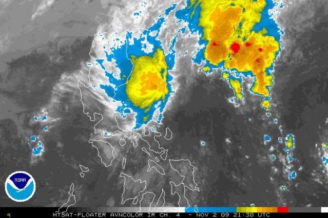
No. That's heavy rain and thunderstorms generated by the precursors of the NE monsoon. It's caused by warm humid tropical air riding up over the cool air that is moving in from the north on northeast winds. Some of this rain could migrate over the Philippines, but even if it doesn't, certainly more of this will develop as we get into the season, as you know.
0 likes
-
ozonepete
- Professional-Met
- Posts: 4743
- Joined: Mon Sep 07, 2009 3:23 pm
- Location: From Ozone Park, NYC / Now in Brooklyn, NY
Re: WPAC : TROPICAL DEPRESSION 24W
dhoeze wrote:Hi guys,
Any map I can see the cold surge of the Northeast Monsoon?
Thanks.
Sure. Look at this InfraRed satellite loop: http://www.ssd.noaa.gov/mtsat/wpac/loop-avn.html
Notice the whitish clouds rushig southward over the water between China and Japan towards the Philippines and also spilling westward towards Hainan and VietNam. That's very cool polar air moving over very warm water. As it does so it gets moistened by the warm moist ocean air and gets chilled and forms fog and low clouds. You can't see the cold air coming down over the land as easily, but if you watch China for instance, you can see it turning grey and whitish (signifies colder air) during the nighttime hours especially. Look at the color key at the bottom. Warmest (blacks) to the left, and coldest (reds) to the right.
0 likes

Re: WPAC : TROPICAL DEPRESSION 24W
ozonepete wrote:neil40 wrote:ozonepete wrote:Not looking too good, and the expected daytime drop in convection as the cloud tops warm is just beginning...
Good Morning,
The "pattern" at the upper-right, is that a part of 24w?
No. That's heavy rain and thunderstorms generated by the precursors of the NE monsoon. It's caused by warm humid tropical air riding up over the cool air that is moving in from the north on northeast winds. Some of this rain could migrate over the Philippines, but even if it doesn't, certainly more of this will develop as we get into the season, as you know.
Thanks!
So, the rain content of that upper-right pattern is more prominent than 24w at the lower-left?
0 likes
-
oaba09
- S2K Supporter
- Posts: 1496
- Age: 37
- Joined: Thu Oct 01, 2009 10:02 am
- Location: Valenzuela, Philippines
- Contact:
PAGASA:
Tropical Depression "TINO" has weakened into a Low Pressure Area (LPA).
Location of Center:
(as of 10:00 a.m.) 120 kms North Northeast of Casiguran, Aurora
Coordinates: 17.5°N, 122.6°E
All public storm warning signals elsewhere now lowered.
However, the Eastern section of Northern and Central Luzon will have occasional to frequent rains which may trigger flashfloods and landslides. br>
With this development and unless regeneration occurs, this is the final bulletin on this weather disturbance.
***********
This thing is done
0 likes
-
ozonepete
- Professional-Met
- Posts: 4743
- Joined: Mon Sep 07, 2009 3:23 pm
- Location: From Ozone Park, NYC / Now in Brooklyn, NY
Re: WPAC : TROPICAL DEPRESSION 24W
neil40 wrote:
Thanks!
So, the rain content of that upper-right pattern is more prominent than 24w at the lower-left?
Yes. The more oranges and reds the stronger the showers and thunderstorms.
0 likes
-
Aslkahuna

- Professional-Met
- Posts: 4550
- Joined: Thu Feb 06, 2003 5:00 pm
- Location: Tucson, AZ
- Contact:
Re: WPAC : TROPICAL DEPRESSION 24W
The following is based upon typhoon climatology and is not a forecast:
In reference to Invest 98W, it is extremely rare for a November typhoon to hit Okinawa-especially one that starts that far out. The Marianas, on the other hand, can get clobbered. The most intense typhoon ever on Guam was STY Karen in November 1962. As for Luzon, storms starting that far out usually have gained enough latitude in the Philippine Sea to recurve before reaching Luzon.
Steve
0 likes
Re:
oaba09 wrote:PAGASA:
Tropical Depression "TINO" has weakened into a Low Pressure Area (LPA).
Location of Center:
(as of 10:00 a.m.) 120 kms North Northeast of Casiguran, Aurora
Coordinates: 17.5°N, 122.6°E
All public storm warning signals elsewhere now lowered.
However, the Eastern section of Northern and Central Luzon will have occasional to frequent rains which may trigger flashfloods and landslides. br>
With this development and unless regeneration occurs, this is the final bulletin on this weather disturbance.
***********
This thing is done
Thank God!
Worry-free-sleep tonight for me.
0 likes
Who is online
Users browsing this forum: No registered users and 19 guests